google.com, pub-0288379932320714, DIRECT, f08c47fec0942fa0 GRAVIR LES MONTAGNES... EN PEINTURE: ALPS
Showing posts with label ALPS. Show all posts

Saturday, March 19, 2022

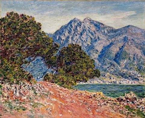
MONT AGEL PAINTED BY CLAUDE MONET


CLAUDE MONET (1840-1926) Mont Agel (1,151m - 3,776 ft) France - Monaco border  In Cap Martin près de Menton, Huile sur toile, 1884  65 x 82cm, Private Collection


CLAUDE MONET (1840-1926)
Mont Agel (1,151m - 3,776 ft)
France - Monaco border

In Cap Martin près de Menton, Huile sur toile, 1884  65 x 82cm, Private Collection 


About this painting
Another painting was done by Monet exactly  in the same place but at a different time of day. It has already been published in this blog. Colors and  general impression are totally different. One can compare the two paintings. this one is supposed to have been painted at 10 a.m, the other à 6 p.m. Monet, like the japanese painters ,and particularly Hokusai who painted the 36 views of Mount Fuji, reproduced the same artistic behavior by painting series of the same mountains, in the same place, at different hours of the day or different seasons. At Cap Martin and Mont Agel, Monet painted about ten of them.

 The mountain
Mont Agel (1,151m - 3,776 ft) is a summit of the Alps located in the South of France, overlooking part of the French Riviera, Monaco, Beausoleil, Roquebrune-Cap-Martin... exactly as shwon in the Monet's painting above !
It has held a historic strategic position since Antiquity and still houses military aerial detection installations today. Mount Agel is precisely located in the French commune of Peille, ( Provence-Alpes-Côte d'Azur region). It rises in the Prealps of Nice and constitutes the highest point of the Monegasque watershed. The highest point of the principality, of Monaco, on the slopes of this mountain, can be reached by the Chemin des Révoires. A massive summit, Mount Agel is visible from a great distance: from certain districts of Nice as well as from a large part of the French Riviera between Cannes, Antibes, Nice, Antibes, and the Principality of Monaco and likewise from the Italian Riviera to around Vintimiglia and Bordighiera.
The history of Mount Agel begins with the Celto-Ligurian tribes who occupied the site and some of whose members were involved in the boarding and looting of boats engaged in cabotage. They are submitted from 23 to 13 BC. BC by the Romans who restored the old coastal route passing through the slopes of Mount Agel to link Ventimiglia to Narbonne Gaul and forming part of the Via Aurelia.
From 1931, new elements of fortification were built within the framework of the Maginot line.
Mount Agel now houses a large work of artillery equipped with turrets, linked together by deeply buried galleries. During the fighting of June 1940, his shots participated in the defense of Menton and supported the outpost of Pont-Saint-Louis and the work of Cap-Martin.
Until 2012, the 943 Capitaine Auber air base of the French Air Force was located there.
Today, only radars remain, which continue their watch in automatic mode, the information being transmitted and used by the Detection and Control Center at 942 Lyon-Mont Verdun air base.
Mount Agel also shelters on its slopes, the Monte-Carlo Golf Club, a very selective club. A little to the east of the golf course is the transmitter center of Fontbonne. Until its recent redevelopment, there were various protohistoric constructions.
Close to Mount Agel and the golf course is also the summer residence of Princes of Monaco (Rocagel site).


The painter
The painter Oscar-Claude Monet better known as Claude Monet was a founder of French Impressionist painting, and the most consistent and prolific practitioner of the movement's philosophy of expressing one's perceptions before nature, especially as applied to plein-air landscape painting. The term "Impressionism" is derived from the title of his painting « Impression, soleil levant » (Impression, Sunrise), which was exhibited in 1874 in the first of the independent exhibitions mounted by Monet and his associates as an alternative to the Salon de Paris.
Monet's ambition of documenting the French countryside led him to adopt a method of painting the same scene many times in order to capture the changing of light and the passing of the seasons exactly like the japanese artist Hokusai (1760-1849) did with his 36 views of Mount Fuji.
Monet repeated this kinf of "exercise de stylee with his series on Les Petites Dalles. and Kolsass mountain.
Monet has been described as "the driving force behind Impressionism". Crucial to the art of the Impressionist painters was the understanding of the effects of light on the local colour of objects, and the effects of the juxtaposition of colours with each other. Monet's long career as a painter was spent in the pursuit of this aim.
In 1856, his chance meeting with Eugene Boudin, a painter of small beach scenes, opened his eyes to the possibility of plein-air painting. From that time, with a short interruption for military service, he dedicated himself to searching for new and improved methods of painterly expression. To this end, as a young man, he visited the Paris Salon and familiarised himself with the works of older painters, and made friends with other young artists.[54] The five years that he spent at Argenteuil, spending much time on the River Seine in a little floating studio, were formative in his study of the effects of light and reflections. He began to think in terms of colours and shapes rather than scenes and objects. He used bright colours in dabs and dashes and squiggles of paint. Having rejected the academic teachings of Gleyre's studio, he freed himself from theory, saying "I like to paint as a bird sings."
In 1877 a series of paintings at Gare St-Lazare had Monet looking at smoke and steam and the way that they affected colour and visibility, being sometimes opaque and sometimes translucent. He was to further use this study in the painting of the effects of mist and rain on the landscape. The study of the effects of atmosphere were to evolve into a number of series of paintings in which Monet repeatedly painted the same subject in different lights, at different hours of the day, and through the changes of weather and season. This process began in the 1880s and continued until the end of his life in 1926.
His first series exhibited as such was of Haystacks, painted from different points of view and at different times of the day. Fifteen of the paintings were exhibited at the Galerie Durand-Ruel in 1891. In 1892 he produced what is probably his best-known series, Twenty-six views of Rouen Cathedral. In these paintings Monet broke with painterly traditions by cropping the subject so that only a portion of the facade is seen on the canvas. The paintings do not focus on the grand Medieval building, but on the play of light and shade across its surface, transforming the solid masonry.
Other series include Peupliers, Matins sur la Seine, and the Nenuphars that were painted on his property at Giverny. Between 1883 and 1908, Monet traveled to the Mediterranean, where he painted landmarks, landscapes, and seascapes, including a series of paintings in Antibes (above) and Venice. In London he painted four series: the Houses of Parliament, London ; Charing Cross Bridge ; Waterloo Bridge, and Views of Westminster Bridge. Helen Gardner writes: "Monet, with a scientific precision, has given us an unparalleled and unexcelled record of the passing of time as seen in the movement of light over identical forms."
___________________________________________

2022 - Wandering Vertexes...
by Francis Rousseau
Sunday, March 6, 2022

DER NIESEN PAINTED BY MARCUS JACOBI

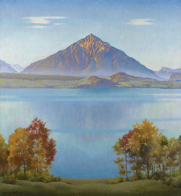
MARCUS JACOBI (1891-1969), Der Niesen (2, 362m - 7,749 ft), Switzerland  "In The Niesen, Lake Thun, Bernese Oberland, Switzerland," oil on canvas, 105 x 96cm. 1941, Courtesy John Mitchell Fine paintings, London

MARCUS JACOBI (1891-1969)
Der Niesen (2, 362m - 7,749ft
Switzerland

In The Niesen, Lake Thun, Bernese Oberland, Switzerland, oil on canvas, 105 x 96cm, 1941,
Courtesy John Mitchell Fine paintings, London 


The mountain
The Niesen (2, 362m - 7,749ft) is a mountain of the Bernese Alps in Switzerland. It overlooks Lake Thun, in the Bernese Oberland region, and forms the northern end of a ridge that stretches north from the Albristhorn and Mannliflue, separating the Simmental and Kandertal valleys. The literal translation of the German word "Niesen" is "sneeze", but the Niesen because of its shape, is often called The Swiss Pyramid. Administratively, the summit is shared between the municipalities of Reichenbach im Kandertal, to the south-east, and Wimmis, to the west and north. Both municipalities are in the canton of Bern. The summit of the mountain can be reached easily by using the Niesenbahn funicular from Mülenen (near Reichenbach). The construction of the funicular was completed in 1910. Alongside the path of the Niesenbahn is the longest stairway in the world with 11,674 steps. It is open only once a year to the public for a stair run.
The literal translation of the German word Niesen is sneeze. Because of its shape, the Niesen is often called the Swiss Pyramid. Since the 18th century, the Niesen was the subject of a number of paintings which will all be published in this blog, one by one. The Ferdinand Holder's paintings are the two first ones to have been published. The Niesen was also the subject of a number of paintings by Paul Klee, in which it was represented as a quasi-pyramid.

The painter
Born in Biel, Marcus Jacobi came from a family of piano manufacturers and went to study medicine in Bern before becoming a painter. In the 1920s he moved to Merligen on the northern shore of Lake Thun from where this summer panorama was painted. Floating between Ferdinand Hodler and Felix Vallotton, two of the giants of Swiss twentieth century painting, Jacobi’s landscape style fused elements of Realism and Symbolism. He became known for his views of the Niesen, the volcano-like peak which rises to well over 2,000 metres and is one of Switzerland’s most iconic mountains.

__________________________________________
2022 - Wandering Vertexes...
by Francis Rousseau

Thursday, October 21, 2021

MONTE CIVETTA PAINTED BY ELIJAH WALTON


ELIJAH WALTON (1832-1880), Monte Civetta (3,220 m - 10, 580 ft) Italy  In Dolomites - in Spring. Civetta from Forcella Staulanza (North East), 1875 oil on canvas, 38 x 183 cm
 
ELIJAH WALTON (1832-1880)
Monte Civetta (3,220 m - 10, 580 ft)
Italy

In Dolomites - in Spring. Civetta from Forcella Staulanza (North East), 1875 oil on canvas, 38 x 183 cm.


The mountain
Monte Civetta (3,220 m - 10, 580 ft) is a prominent and major mountain of the Dolomites, in the Province of Belluno in northern Italy. Its north-west face can be viewed from the Taibon Agordino valley, and is classed as one of the symbols of the Dolomites. The mountain is thought to have been first climbed by Simeone di Silvestro in 1855, which, if true, makes it the first major Dolomite peak to be climbed. The north-western face, with its 1,000-metre-high cliff, was first climbed in 1925 by Emil Solleder and Gustl Lettenbauer. It is historically considered the first "sixth grade" in six-tier scale of alpinistic difficulties proposed by Willo Welzenbach (corresponding to 5.9). Thirty years later UIAA used this as a basis for its grading system. The famed Svan mountain climber Mikhail Khergiani died in a climbing accident on Monte Civetta in 1969.

The artist
The British landscapist, Elijah Walton is best known for his landscapes of mountains in the Alps. Due to the poorness of his family, without the help of one or two friends he would have been unable to study art, for which his talent was soon exhibited. After passing some years at the art academy in Birmingham, he became at the age of eighteen a student at the Royal Academy Schools in London, where he had already exhibited a picture. There he worked assiduously, drawing from the antique and from life. Nearly ten years later an accidental circumstance revealed to a friend his capabilities in mountain landscape, and in 1860, immediately after his marriage, he went to Switzerland. Thence he proceeded to Egypt, where unhappily his wife died of dysentery near the second cataract. He remained in the east, spending some time in Syria and at Constantinople, till the spring of 1862, when he returned for a short time to London. But for the next five years he was much abroad, working either in the Alps or in Egypt. His sketching tours then became rarer and shorter, though he visited Greece, Norway, and the Alps. At first he resided at Staines, then removed to the neighbourhood of Bromsgrove, living most of the time at the Forelands, near that town. In 1872 his wife died, and the loss permanently affected his health. He died on 25 August 1880 at his residence Beacon Farm, Lickey near Bromsgrove in Worcestershire, leaving three sons. Walton's life was bound up in his art. He worked both in oils and in watercolours, but was more successful with the latter. Most thorough and conscientious in the study both of form and of colour, he delighted especially in mountain scenery and in atmospheric effects, such as an Alpine peak breaking through the mists, or a sunset on the Nile. Few men have equalled him in the truthful rendering of rock structure and mountain form. His pictures were much appreciated by lovers of nature; but as those of small size sold better than larger and more highly finished works, this fostered a tendency to mannerisms.

___________________________________________
2021 - Wandering Vertexes...
by Francis Rousseau

Monday, October 18, 2021

PIZ BALZET, PUNTA DE L'ALBIGNA, SPAZZACALDEIRA BY GIOVANNI GIACOMETTI

GIOVANNI GIACOMETTI (1868-1933), Piz Balzet (2, 869 m - 9,413 ft), Punta de l'Albigna (2,825 m - 9,268 ft), Spazzacaldeira (2,487 m- 8,159 ft) ,Switzerland  In  Albigna Valley, oil on canvas, 1932

GIOVANNI GIACOMETTI (1868-1933)
Piz Balzet (2, 869 m - 9,413 ft)
Punta de l'Albigna (2,825 m - 9,268 ft)
Spazzacaldeira (2,487 m- 8,159 ft)
Switzerland
 In  Albigna Valley, oil on canvas,  1932

The Mountains 

The Piz Balzet  (2, 869 m - 9,413 ft)  is a  tall granite mountain located in Bergell, Switzerland. Standing just on the eastern edge of the Albigna reservoir it is clearly visible when driving down from the Maloja-pass to the north and from the campsite at Vicosoprano. Seen from this (its western) side the Balzet is an imposing picture; very steep slabs fall off into the valley and several ridges make their way to the well defined summit. A different picture entirely is presented when the mountain is viewed from its southern side; from this side there are no steep drops to valley floors far below. Instead, it is 'merely' a summit in the ridge leading up to the Piz Bacun (3,244m).
The Punta da l'Albigna  (2,825 m - 9,268 ft) is an easily recognizable summit on the eastern side of the Albigna lake in the Bergell, an area in south-eastern Switzerland famous for its multitude of alpine rock climbs on excellent granite. Along with the Spazzacaldeira and the Piz Balzet, the Punta da l'Albigna ranks among the most popular climbing hotspots in the Albigna area. It hosts numerous routes from 4a to 5c and varying in length between 8 and 12 ropelengths. Most of the routes are bolted, though some rather sparingly
Spazzacaldeira (2,487 m- 8,159 ft) is the name of the ridge directly west of the Albigna reservoir, just to the north of the Al Gal. It offers a multitude of alpine-sport routes across its eastern face and the north-east ridge is a well known classic in the area. Because of the generally well bolted nature of the routes and the incredibly easy access via the nearby cable car station, Spazzacaldeira can attract a large number of climbers. Most of them will be aiming for the summit pinnacle, the famous Fiamma, a striking summit spire seen on many local postcards.

The painter
Giovanni Giacometti was a Swiss painter, the father of the famous painter and sculptor Alberto Giacometti, and of Diego Giacometti, the furniture designer as well as the father of the architect Bruno Giacometti ! In 1886, he studied painting at the School of Decorative Arts in Munich, where he met Cuno Amiet the following year. Both decide to pursue their studies in Paris, in October stood at the Académie Julian, where Giacometti remains until 1891.
In 1893, shortly after his return to Switzerland, to Bergell, he became friends with Giovanni Segantini, his eldest ten years, which has great influence on his work by opening it to the beauty of the mountain scenery and the rules of divisionism. After his sudden death in 1899, Giacometti met Ferdinand Hodler, who teaches him to create a rigorous and ornamental composition by appropriate use of shapes and colors.
He sees regularly Cuno Amiet, who after a year spent in Pont-Aven, shared his experience with him. In 1900 he exhibited in the Swiss Pavillon of the Universal Exhibition in Paris. From 1905, Giacometti works again in a great complicity with Amiet and begins to break free from the influence of Segantini. In 1906, held an exhibition of his work at Kunstlerhaus Zurich. In 1907 he went to Paris with Amiet to the Cézanne retrospective at the Salon d'Automne. They copy all the works of Van Gogh. In 1908, he exhibited with the French Fauves at the Richter Gallery in Dresden.
In 1909, the Tannhauser Gallery presents his works in Munich. He meets Alexi von Jawlensky, and in 1911 participates in the Berlin Secession. In 1912, Giacometti has a solo show at the Kunsthaus Zurich presents two works in the Sonderbund of Cologne. In 1918 after Hodler' s death, he began to be involved into the Swiss political world paying an important part as a committed artist, following int that way friend Amiet.

___________________________
2021 - Wandering Vertexes...
by Francis Rousseau


Wednesday, October 13, 2021

THE MONT BLANC & THE MER DE GLACE BY JOHN RUSKIN

JOHN RUSKIN (1819-1900), The Mont Blanc (4,808.13 m - 15,776.7 ft) France - Italy border  In Mer de Glace Chamonix, watercolor on paper, 1849, Ruskin Foundation


JOHN RUSKIN (1819-1900),
The Mont Blanc (4,808.13 m - 15,776.7 ft)
France - Italy border

In Mer de Glace Chamonix, watercolor on paper, 1849, Ruskin Foundation

The painter  
John Ruskin was the leading English art critic of the Victorian era, as well as an art patron, draughtsman, watercolourist, a prominent social thinker and philanthropist. He wrote on subjects as varied as geology, architecture, myth, ornithology, literature, education, botany and political economy. His writing styles and literary forms were equally varied. Ruskin also penned essays and treatises, poetry and lectures, travel guides and manuals, letters and even a fairy tale. The elaborate style that characterised his earliest writing on art was later superseded by a preference for plainer language designed to communicate his ideas more effectively. In all of his writing, he emphasised the connections between nature, art and society. He also made detailed sketches and paintings of rocks, plants, birds, landscapes, and architectural structures and ornamentation. He was hugely influential in the latter half of the 19th century, and up to the First World War. After a period of relative decline, his reputation has steadily improved since the 1960s with the publication of numerous academic studies of his work. Today, his ideas and concerns are widely recognised as having anticipated interest in environmentalism, sustainability and craft.
Ruskin first came to widespread attention with the first volume of Modern Painters (1843), an extended essay in defence of the work of J. M. W. Turner in which he argued that the principal role of the artist is "truth to nature". From the 1850s he championed the Pre-Raphaelites who were influenced by his ideas. His work increasingly focused on social and political issues. Unto This Last (1860, 1862) marked the shift in emphasis. In 1869, Ruskin became the first Slade Professor of Fine Art at the University of Oxford, where he established the Ruskin School of Drawing. In 1871, he began his monthly "letters to the workmen and labourers of Great Britain", published under the title Fors Clavigera (1871–1884). In the course of this complex and deeply personal work, he developed the principles underlying his ideal society. As a result, he founded the Guild of St George, an organisation that endures today.

The mountain
Mont Blanc (in French) or Monte Bianco (in Italian), both meaning "White Mountain", is the highest mountain in the Alps and the highest in Europe after the Caucasus peaks. It rises 4,808.73 m (15,777 ft) above sea level and is ranked 11th in the world in topographic prominence. The Mont Blanc is one of the Seven Summit, which includes the highest mountains of each of the seven continents. Summiting all of them is regarded as a mountaineering challenge, first achieved on April 30, 1985 by Richard Bass. The 7 highest summit, (which are obviously 8 with 2 in Europe !) are : Mount Everest (8,848m), Aconcagua (6,961m), Mt Denali or Mc Kinley (6,194m), Kilimandjaro (5,895m), Mt Elbrus (5,642m), Mount Vinson (4,892m) and Mount Kosciuszko (2,228m) in Australia.
The Glacier
The Mer de Glace  ( Sea of Ice) is an alpine valley glacier located on the northern slope of the Mont-Blanc massif, in the French department of Haute-Savoie. It is formed by the confluence of the Tacul glacier and the Leschaux glacier and flows into the Arve valley, on the territory of the municipality of Chamonix-Mont-Blanc, giving rise to the Arveyron. The glacier is seven kilometers long, its supply basin has a maximum length of twelve kilometers and an area of ​​40 km2, while its thickness reaches 300 meters.
In the seventeenth century, the glacier, which descends into the valley and threatens homes, is feared by the population, so that only its terminal tongue is known, under the name of Glacier des Bois. Then finished by a natural cave, it is the subject of numerous paintings. Its current name was given to it in 1741 by William Windham during the exploration he carried out with his British compatriot Richard Pococke. Two decades later, Horace-Bénédict de Saussure, the future instigator of the first ascent of Mont Blanc, made several observations of the glacier and asked Marc-Théodore Bourrit to promote it. It thus contributes to the development of alpine tourism and to the visit of numerous personalities of letters as well as of the aristocracy; scientists carried out experiments there in the 19th century. To shelter them, three increasingly large and comfortable shelters were successively built in Montenvers. At the beginning of the 20th century, the Montenvers railway, leaving from Chamonix, was created. In the middle of the century, an ice cave was pierced for the first time in the Mer de Glace. Due to the attraction's success, a cable car was put into service in 1961 to access it, then replaced by a cable car in 1988. Since 1973, an underground hydroelectric power station has been using the meltwater from the glacier.
Almost a million visitors go to Montenvers every year to contemplate the Mer de Glace. During peak periods, half of them visit the ice cave. Three museums are also located on the site. Skiing is possible from the Aiguille du Midi in winter. However, the retreat of the glacier, measured since 1860-1870, causes a loss of thickness of 120 meters in a century in its terminal part. It causes difficulties at the level of the ice cave, where more and more steps are necessary to reach the gondola, and requires considering its upstream movement, like the catchment of the hydroelectric power station in 2011.
_______________________________


2021 - Wandering Vertexes...
by Francis Rousseau

Sunday, October 10, 2021

MONT AGEL PAINTED BY CLAUDE MONET

CLAUDE MONET  (1840-1926) Mont Agel  (1,151m - 3,776 ft) France - Monaco border  In Cap Martin près de Menton, Huile sur toile, Museum of Fine Arts, Boston

CLAUDE MONET  (1840-1926)
Mont Agel  (1,151m - 3,776 ft)
France - Monaco border

In Cap Martin près de Menton, Huile sur toile, Museum of Fine Arts, Boston 


The mountain
Mont Agel (1,151m - 3,776 ft) is a summit of the Alps located in the South of France, overlooking part of the French Riviera, Monaco, Beausoleil, Roquebrune-Cap-Martin... exactly as shwon in the Monet's painting above !
It has held a historic strategic position since Antiquity and still houses military aerial detection installations today. Mount Agel is precisely located in the French commune of Peille, ( Provence-Alpes-Côte d'Azur region). It rises in the Prealps of Nice and constitutes the highest point of the Monegasque watershed. The highest point of the principality, of Monaco, on the slopes of this mountain, can be reached by the Chemin des Révoires. A massive summit, Mount Agel is visible from a great distance: from certain districts of Nice as well as from a large part of the French Riviera between Cannes, Antibes, Nice, Antibes, and the Principality of Monaco and likewise from the Italian Riviera to around Vintimiglia and Bordighiera.
The history of Mount Agel begins with the Celto-Ligurian tribes who occupied the site and some of whose members were involved in the boarding and looting of boats engaged in cabotage. They are submitted from 23 to 13 BC. BC by the Romans who restored the old coastal route passing through the slopes of Mount Agel to link Ventimiglia to Narbonne Gaul and forming part of the Via Aurelia.
From 1931, new elements of fortification were built within the framework of the Maginot line.
Mount Agel now houses a large work of artillery equipped with turrets, linked together by deeply buried galleries. During the fighting of June 1940, his shots participated in the defense of Menton and supported the outpost of Pont-Saint-Louis and the work of Cap-Martin.
Until 2012, the 943 Capitaine Auber air base of the French Air Force was located there.
Today, only radars remain, which continue their watch in automatic mode, the information being transmitted and used by the Detection and Control Center at 942 Lyon-Mont Verdun air base.
Mount Agel also shelters on its slopes, the Monte-Carlo Golf Club, a very selective club. A little to the east of the golf course is the transmitter center of Fontbonne. Until its recent redevelopment, there were various protohistoric constructions.
Close to Mount Agel and the golf course is also the summer residence of Princes of Monaco (Rocagel site).


The painter
The painter Oscar-Claude Monet better known as Claude Monet was a founder of French Impressionist painting, and the most consistent and prolific practitioner of the movement's philosophy of expressing one's perceptions before nature, especially as applied to plein-air landscape painting. The term "Impressionism" is derived from the title of his painting « Impression, soleil levant » (Impression, Sunrise), which was exhibited in 1874 in the first of the independent exhibitions mounted by Monet and his associates as an alternative to the Salon de Paris.
Monet's ambition of documenting the French countryside led him to adopt a method of painting the same scene many times in order to capture the changing of light and the passing of the seasons exactly like the japanese artist Hokusai (1760-1849) did with his 36 views of Mount Fuji.
Monet repeated this kinf of "exercise de stylee with his series on Les Petites Dalles. and Kolsass mountain.
Monet has been described as "the driving force behind Impressionism". Crucial to the art of the Impressionist painters was the understanding of the effects of light on the local colour of objects, and the effects of the juxtaposition of colours with each other. Monet's long career as a painter was spent in the pursuit of this aim.
In 1856, his chance meeting with Eugene Boudin, a painter of small beach scenes, opened his eyes to the possibility of plein-air painting. From that time, with a short interruption for military service, he dedicated himself to searching for new and improved methods of painterly expression. To this end, as a young man, he visited the Paris Salon and familiarised himself with the works of older painters, and made friends with other young artists.[54] The five years that he spent at Argenteuil, spending much time on the River Seine in a little floating studio, were formative in his study of the effects of light and reflections. He began to think in terms of colours and shapes rather than scenes and objects. He used bright colours in dabs and dashes and squiggles of paint. Having rejected the academic teachings of Gleyre's studio, he freed himself from theory, saying "I like to paint as a bird sings."
In 1877 a series of paintings at Gare St-Lazare had Monet looking at smoke and steam and the way that they affected colour and visibility, being sometimes opaque and sometimes translucent. He was to further use this study in the painting of the effects of mist and rain on the landscape. The study of the effects of atmosphere were to evolve into a number of series of paintings in which Monet repeatedly painted the same subject in different lights, at different hours of the day, and through the changes of weather and season. This process began in the 1880s and continued until the end of his life in 1926.
His first series exhibited as such was of Haystacks, painted from different points of view and at different times of the day. Fifteen of the paintings were exhibited at the Galerie Durand-Ruel in 1891. In 1892 he produced what is probably his best-known series, Twenty-six views of Rouen Cathedral. In these paintings Monet broke with painterly traditions by cropping the subject so that only a portion of the facade is seen on the canvas. The paintings do not focus on the grand Medieval building, but on the play of light and shade across its surface, transforming the solid masonry.
Other series include Peupliers, Matins sur la Seine, and the Nenuphars that were painted on his property at Giverny. Between 1883 and 1908, Monet traveled to the Mediterranean, where he painted landmarks, landscapes, and seascapes, including a series of paintings in Antibes (above) and Venice. In London he painted four series: the Houses of Parliament, London ; Charing Cross Bridge ; Waterloo Bridge, and Views of Westminster Bridge. Helen Gardner writes: "Monet, with a scientific precision, has given us an unparalleled and unexcelled record of the passing of time as seen in the movement of light over identical forms."
___________________________________________

2021 - Wandering Vertexes...
by Francis Rousseau


Wednesday, September 22, 2021

THE CERVIN / MATTERHORN PAINTED BY GABRIEL LOPPÉ

GABRIEL LOPPÉ (1825-1913) Le Cervin or Matterhorn (4,478m -14,691ft) Switzerland - Italy border  In "Le Mont Cervin par temps nuageux, l'après midi", étude, huile sur toile 29x 18, 5cm, 1884.

GABRIEL LOPPÉ (1825-1913)
Le Cervin or Matterhorn (4,478m -14,691ft)
Switzerland - Italy border

In "Le Mont Cervin par temps nuageux, l'après midi", étude, huile sur toile 29x 18, 5cm, 1884.

The mountain
The Mont Cervin (4,478m -14,691ft) also known as the Matterhorn is an alpine summit located on the Swiss-Italian border between the canton of Valais and the Aosta Valley in Switzerland. It has several other names: Cervino in Italian, Grand'Bèca in Arpitan, Matterhorn in German. The Cervin / Matterhorn is the most famous mountain in Switzerland, including the pyramidal shape that it offers from the village of Zermatt, in the German-speaking part of the canton of Valais.
Its four sides are joined about 400 meters below the summit in a summit pyramid, called "roof." Its summit is a broad ridge about two meters, on which stand actually two summits: one called "Swiss summit," the farther east, and the "Italian summit" slightly lower (4,476 meters), on the west side of the ridge. The two are separated by a notch in the hollow of which a cross was laid in September 1901.
Its north face is one of the three great north faces of the Alps with the Eiger and the Grandes Jorasses.
The most famous faces of the Matterhorn are the faces east and north, seen from Zermatt. The first
1, 000 meters high, has great risk of falling rocks, which makes it dangerous climb. The north face high of 1100 meters, is one of the most dangerous sides of the Alps, particularly because of the risks of landslides and storms. The south side, overlooking the Breuil (Valtournenche above) is high, it, 1 350 meters. This is the face that offers the most channels. And finally, the west face the highest with its 1400 meters, is the one that is the subject of fewer climbs attempts. Between the west side and the north side there is also the north-northwest side, which does not stretch to the summit but stopped Zmutt Nose, on the bridge of the same name. This is the most dangerous route for climbing the Matterhorn. There is also a south-facing southeast, deemed to be the most difficult of the south face route, which leads to the Pic Muzio, on Furggen Shoulder.
Due to its pyramidal form, the Matterhorn has four main ridges, through which pass most of climbing routes. The easiest ridge, that borrows the normal route, is the Hörnli ridge (Hörnligrat in German): it is between the faces east and north, facing the Zermatt valley. Further west lies the Zmutt ridge (Zmuttgrat), between the north and west sides. Between the western and southern sides is the Lion ridge (Liongrat), also known as Italian ridge, which passes through the Tyndall peak, summit of the southern part of the west side, at which begins the upper face. Finally, the south side is separated from the face is Furggen
Swiss normal route from the cabin of the Hörnli, located at 3260 meters. Since Zermatt is accessed by gondola Schwarzsee; there are 700 vertical meters to the hut and 1200 vertical meters to the summit.
Difficulty (Hörnli ridge): AD (fairly difficult), 3 climbing passage; fixed ropes were installed near the top for easy ascension.
The Italian normal route, taking his departure in Breuil, follows almost entirely the southwest ridge, called the Lion ridge. It was inaugurated by the guide valtournain Jean-Antoine Carrel 17 July 1865.
The climb from the Italian side includes three steps:
- du Breuil (2012 meters) at the shelter Duke of Abruzzi in Oriondé (2802 meters)
- the refuge Duca degli Abruzzi refuge to Jean-Antoine Carrel (3830 meters)
- Jean-Antoine Carrel refuge at the summit (4478 meters).
The ascent by Hörnli ridge, July 14, 1865, was considered the last of the great feats of mountaineering in the Alps. But this ascent error ended at the beginning of the descent, in the death of 4 of the 7 members of the roped Victorieuse.

The painter
Toussaint Gabriel Loppé was a French painter, photographer and mountaineer. He became the first foreigner to be made a member of the Alpine Club in London. His father was a captain in the French Engineers and Loppé's childhood was spent in many different towns in south-eastern France. Aged twenty-one Loppé climbed a small mountain in the Languedoc and found a group of painters sketching on the summit. He had found his calling and subsequently went off to Geneva where he met the reputed leading Swiss landscapist, Alexandre Calame (1810 -1864). Loppé took up mountaineering in Grindelwald in the 1850s and made friends easily with the many English climbers in France and Switzerland. Although he was frequently labelled as a pupil of Calame and his rival François Diday, Loppé was almost an entirely self-taught artist. He became the first painter to work at higher altitudes during climbing expeditions earning the right to be considered the founder of the peintres-alpinistes school, which became established in the Savoie at the turn of the nineteenth century.
Notable followers of Loppé include, Charles Henri Contencin (1875-1955) and Jacques Fourcy (1906-1990). Together with the first ascent of Mt Mallet in Chamonix’s Grandes Jorasses range, Loppé made over 40 ascents of Mont Blanc during his climbing career, which lasted until the late 1890s. He frequently made oil sketches from alpine summits, including a panorama of the view from the summit of Mont Blanc.
His paintings became celebrated for their atmosphere and spontaneity and he soon found himself taking part in many exhibitions in London and in Paris.
By 1896 Loppé had spent over fifty seasons climbing and painting in Chamonix. As the valley’s unrivalled ‘Court painter’ his work was in constant demand with the majority of his pictures going to English climbers and summer tourists.
In his later years, Loppé became fascinated with photography and was quite an innovator in this field too. His long exposure photograph of the Eiffel Tower struck by lightning, now in the Musée d'Orsay in Paris remains one of his iconic images.

___________________________________________

2021 - Wandering Vertexes...
by Francis Rousseau


Wednesday, August 11, 2021

DIE HOCHFEILER OR GRAN PILASTRO BY AUGUST STRINDBERG


-AUGUST STRINDBERG (1849-1912) The Hochfeiler or Gran Pilastro  (3,510 m -11,520 ft) Austria - Italy border In Alpine Landscape Austria, oil on canvas , Priva te collection

AUGUST STRINDBERG (1849-1912)
The Hochfeiler or Gran Pilastro (3,510 m -11,520 ft)
Austria - Italy border
 
In Alpine Landscape Austria, oil on canvas, Private collection

The artist
Johan August Strindberg known to be a famous  Swedish playwright was also  a novelist a poet, an essayist and a painter. Strindberg, something of a polymath, was also a telegrapher, theosophist, photographer and alchemist!  Painting and photography offered vehicles for his belief that chance played a crucial part in the creative process. Strindberg's paintings were unique for their time, and went beyond those of his contemporaries for their radical lack of adherence to visual reality. The 117 paintings that are acknowledged as his were mostly painted within the span of a few years, and are now seen by some as among the most original works of 19th-century art. Today, his best-known pieces are stormy, expressionist seascapes, selling at high prices in auction houses. Though Strindberg was friends with Edvard Munch and Paul Gauguin, and was thus familiar with modern trends, the spontaneous and subjective expressiveness of his landscapes and seascapes can be ascribed also to the fact that he painted only in periods of personal crisis. Anders Zorn also did a portrait.
Strindberg's interest in photography resulted, among other things, in a large number of arranged self-portraits in various environments, which now number among the best-known pictures of him. Strindberg also embarked on a series of camera-less images, using an experimental quasi-scientific approach. He produced a type of photogram that encouraged the development and growth of crystals on the photographic emulsion, sometimes exposed for lengthy periods to heat or cold in the open air or at night facing the stars. The suggestiveness of these, which he called Celestographs, provided an object for contemplation, and he noted: "Today, in these days of x-rays, the miracle was that neither a camera nor a lens was used. For me this means a great opportunity to demonstrate the real circumstances by means of my photographs made without a camera and lens, recording the firmament in early spring 1894."
His interest in the occult in the 1890s finds sympathy with the chance quality of these images, but for him they are also scientific. In 1895 Strindberg met Camille Flammarion and became a member of the Société astronomique de France. He gave some of his experimental astronomical photographs to the Society

The mountain
The Hochfeiler 3,510 m (11,520 ft) called Gran Pilastro in italian is a mountain, 3,510 metres high, and the highest peak in the Zillertal Alps on the border between Tyrol, Austria, and South Tyrol, Italy.

___________________________________________

2021 - Wandering Vertexes...
by Francis Rousseau

Wednesday, July 28, 2021

THE MONT BLANC PAINTED BY JEAN-ANTOINE LINCK


JEAN-ANTOINE LINCK (1766-1843)
The Mont Blanc (4,808.73 m -15,777 ft)
France-Italy border

In Vue du Mont blanc à partir du Col de Balme, Estampe, 50 x50cm, 
Musée Alpin de Chamonix-Mont-Blanc


About this picture
This print represents the Chamonix valley seen from the Col de Balme. This point of view allows the spectator to embrace the major part of the Mont-Blanc massif and the valley bottom by following the course of the Arve. Jean-Antoine Linck offers a relatively realistic panorama, sometimes exaggerating the bristling of summits and seracs. In the foreground, the artist has placed a few figures who seem to be tourists in awe of the landscape accompanied by a guide leaning against the border post with his two mules. Linck was trained in Geneva in his father's workshop in the context of the "Fabrique" which brings together watchmakers, jewelers and painters on enamel. It was in this dynamic artistic environment of the second half of the 18th century that the first engravers appeared who made the Chamonix valley known through their watercolor prints. A real industry of landscape engraving is then set up. Linck is one of the greatest representatives of this artistic movement linked to the rise of alpine tourism and a new craze for the landscape. He creates high-quality etched works, very popular with travelers, which he sells in his Geneva boutique. In his "Manual of the traveler in Switzerland" of 1818, Ebel moreover advises the latter in order to find the best artists. He quotes Linck in particular and specifies that this print was worth 18 pounds, a fairly large sum for the time. Despite everything, the print is reproducible and cheaper than a painting. It therefore lends itself perfectly to the request of visitors to take with them views of the regions visited.

The artist
Jean-Antoine Linck, is a swiss painter and draftsman who lived and worked at the end of the 18th century and beginning of 19th century, at the time nature and mountains were up to date in high society in Switzerland and France.He is the son of Jean-Conrad, an enameller and engraver from Geneva who initiates his apprenticeship. He was then trained by Carl Hackert with Wolfgang Adam Toepffer. In 1802, he opened his own studio in Geneva, in the district of Montbrillant. His works, depicting the surroundings of Geneva, Savoy, the Alps and the Mont Blanc, were inspired by those of the great master of that " genre" Johann Ludwig Aberli and were successful with Josephine de Beauharnais, the French Empress and Catherine II, the Russian Empress, meanwhile alpine tourism began to develop

The mountain
The Mont Blanc (4,808.73 m -15,777 ft) or Monte Bianco, both meaning "White Mountain", is the highest mountain in the Alps and the highest in Europe after the Caucasus peaks. It is ranked 11th in the world in topographic prominence. The Mont Blanc is one of the Seven Summit, which includes the highest mountains of each of the seven continents. Summiting all of them is regarded as a mountaineering challenge, first achieved on April 30, 1985 by Richard Bass. The 7 highest summits, (which are obviously 8 with 2 in Europe !) are :
Mount Everest (8,848m), Aconcagua (6,961m), Mt Denali or Mc Kinley (6,194m), Kilimandjaro (5,895m), Mt Elbrus (5,642m), Mount Vinson (4,892m) and Mount Kosciuszko (2,228m) in Australia.
The mountain lies in a range called the Graian Alps, between the regions of Aosta Valley, Italy, and Savoie and Haute-Savoie, France. The location of the summit is on the watershed line between the valleys of Ferret and Veny in Italy and the valleys of Montjoie, and Arve in France. The Mont Blanc massif is popular for mountaineering, hiking, skiing, and snowboarding.
The three towns and their communes which surround Mont Blanc are Courmayeur in Aosta Valley, Italy, and Saint-Gervais-les-Bains and Chamonix in Haute-Savoie, France. A cable car ascends and crosses the mountain range from Courmayeur to Chamonix, through the Col du Géant. Constructed beginning in 1957 and completed in 1965, the 11.6 km (7¼ mi) Mont Blanc Tunnel runs beneath the mountain between these two countries and is one of the major trans-Alpine transport routes.
Since the French Revolution, the issue of the ownership of the summit has been debated.
From 1416 to 1792, the entire mountain was within the Duchy of Savoy. In 1723 the Duke of Savoy, Victor Amadeus II, acquired the Kingdom of Sardinia. The resulting state of Sardinia was to become preeminent in the Italian unification.[ In September 1792, the French revolutionary Army of the Alps under Anne-Pierre de Montesquiou-Fézensac seized Savoy without much resistance and created a department of the Mont-Blanc. In a treaty of 15 May 1796, Victor Amadeus III of Sardinia was forced to cede Savoy and Nice to France. A Sardinian Atlas map of 1869 showing the summit lying two thirds in Italy and one third in France.
Although the Franco-Italian border was redefined in both 1947 and 1963, the commission made up of both Italians and French ignored the Mont Blanc issue. In the early 21st century, administration of the mountain is shared between the Italian town of Courmayeur and the French town of Saint-Gervais-les-Bains, although the larger part of the mountain lies within the commune of the latter.

_______________________________________


2021 - Wandering Vertexes...
by Francis Rousseau

Saturday, July 3, 2021

THE DENTS DU MIDI PAINTED BY JEAN-ANTOINE LINCK

JEAN-ANTOINE LINCK (1766 - 1843) Les Dents du Midi (3,114 m to 3,257 m -10,216 ft to10,685 ft) Switzerland  In Vue la Dent du Midi et du Château de Lanex prise près d'Aigle, Original coloured etching, 36 x 48 cm

JEAN-ANTOINE LINCK (1766 - 1843)
Les Dents du Midi (3,114 m to 3,257 m -10,216 ft to10,685 ft)
Switzerland

In Vue la Dent du Midi et du Château de Lanex prise près d'Aigle, Original coloured etching, 36 x 48 cm


The mountain
The Dents du Midi (Teeth of the south) (3,114 m to 3,257 m -10,216 ft to 10,685 ft) are a mountain range, 3 kilometers long, located in the Chablais Alps in the canton of Valais in Switzerland. Overlooking the valley of Illiez and Rhône Valley on south, they face the lake Salanfe, an artificial reservoir, and are part of the geological whole massif Giffre.
The name "Dents du Midi" is recent. The people formerly called them "Dents Tsallen". It was only towards the end of the19e century that the name "Dents du Midi" came officially.
Each « tooth » had several names over the centuries and according to its geological evolution.
- The "Cime de l'Est" (3,178 meters) called "Mont Novierre" before the mid-17th century, and "Mont Saint-Michel "after landslides in 1635 and 1636 and finally "Dent Noire" (until the 19th century).
- The "Dent Jaune" (3,186 m) was called the "Dent Rouge" until 1879.
- The "Doigt de Champéry" (in 1882) and then the Doigt Salanfe (in 1886) turned just into "Les Doigts" (Fingers) (3,205 m and 3210 m).
- The "Haute Cime" (3,257 m) also had many names : "Dent de l’Ouest" (until 1784) and then "Dent du Midi", "Dent de Tsallen" and "Dent de Challent."
- As for l’Eperon (3,114 m) (The Spur), it is assumed that there were two peaks but a landslide in the Middle Ages significantly changed its crest.
- The Forteresse (3,164 m) and the Cathedral (3,160 m) have not changed names.
The evolution of this massif continues nowadays. So on the morning of 30 October 2006, a volume of 1 million m3 of rock broke away from the edge of the Haute Cime and slid down the slope to an altitude of about 3,000 m. The event did not present danger to the nearby village of Val-d'Illiez but roads and trails were closed for security reasons. According to the cantonal geologist, the landslide was caused by the thawing of rocks, helped by warm summers of recent years.


The artist
Jean-Antoine Linck, is a swiss painter and draftsman who lived and worked at the end of the 18th century and beginning of 19th century, at the time nature and mountains were up to date in high society in Switzerland and France.He is the son of Jean-Conrad, an enameller and engraver from Geneva who initiates his apprenticeship. He was then trained by Carl Hackert with Wolfgang Adam Toepffer. In 1802, he opened his own studio in Geneva, in the district of Montbrillant. His works, depicting the surroundings of Geneva, Savoy, the Alps and the Mont Blanc, were inspired by those of the great master of that " genre" Johann Ludwig Aberli and were successful with Josephine de Beauharnais, the French Empress and Catherine II, the Russian Empress, meanwhile alpine tourism began to develop.

__________________________________
2021 - Wandering Vertexes...
by Francis Rousseau


Saturday, May 15, 2021

MONTE BIANCO PAINTED BY CESARE MAGGI


Cesare Maggi (1881–1962) The Mont Blanc (4,808.13 m - 15,776.7 ft) France - Italy border  In  A view of Mont Blanc from Entrèves, Oil on canvas ,70x100 cm,  Private collection
 
 CESARE MAGGI (1881-1962)
The Mont Blanc (4,808.13 m - 15,776.7 ft)
France - Italy border

In  A view of Monte Bianco from Entrèves, Oil on canvas, 70x100 cm,  Private collection 


The painter
The italian painter Cesare Maggi was born into a family of actors, Maggi embarked on classical studies at his father’s wish but also took up painting at a very early age His debut in Florence at the Esposizione Annuale della Società di Belle Arti di Firenze in 1898 was followed by a short trip to Paris to catch up with the latest developments.
The crucial turning point in Maggi’s art came in 1889 with the posthumous show of work by Giovanni Segantini held by the Milanese Society of Fine Arts, which prompted a definitive shift to landscape painting of a Divisionist character. After a short stay in the Engadin, he returned to Milan before finally settling in Turin. Commercial collaboration with Alberto Grubicy until 1913 enabled Maggi to establish himself quickly as one of the leading representatives of the second generation of Divisionist painters in Italy. He painted a repertoire of readily comprehensible mountain landscapes focusing primarily on aspects of the visual perception of the reflection of light and colour but lacking the deep spirituality of Segantini’s work. He took part in the major Italian and European exhibitions and the Venice Biennale devoted an entire room to his work at the Esposizione Internazionale d’Arte of Venice in 1912. After an interlude devoted to portrait painting in the same decade, the artist’s mature work focused on greater simplification of subject matter, mostly in landscapes.
Maggi obtained the chair in painting at the Albertina Academy, Turin, in 1936.


The mountain
Mont Blanc (in French) or Monte Bianco (in Italian), both meaning "White Mountain", is the highest mountain in the Alps and the highest in Europe after the Caucasus peaks. It rises 4,808.73 m (15,777 ft) above sea level and is ranked 11th in the world in topographic prominence. The Mont Blanc is one of the Seven Summit, which includes the highest mountains of each of the seven continents. Summiting all of them is regarded as a mountaineering challenge, first achieved on April 30, 1985 by Richard Bass. The 7 highest summit, (which are obviously 8 with 2 in Europe !) are : Mount Everest (8,848m), Aconcagua (6,961m), Mt Denali or Mc Kinley (6,194m), Kilimandjaro (5,895m), Mt Elbrus (5,642m), Mount Vinson (4,892m) and Mount Kosciuszko (2,228m) in Australia.
The mountain lies in a range called the Graian Alps, between the regions of Aosta Valley, Italy, and Savoie and Haute-Savoie, France. The location of the summit is on the watershed line between the valleys of Ferret and Veny in Italy and the valleys of Montjoie, and Arve in France. The Mont Blanc massif is popular for mountaineering, hiking, skiing, and snowboarding.
The three towns and their communes which surround Mont Blanc are Courmayeur in Aosta Valley, Italy, and Saint-Gervais-les-Bains and Chamonix in Haute-Savoie, France. A cable car ascends and crosses the mountain range from Courmayeur to Chamonix, through the Col du Géant. Constructed beginning in 1957 and completed in 1965, the 11.6 km (7¼ mi) Mont Blanc Tunnel runs beneath the mountain between these two countries and is one of the major trans-Alpine transport routes.
Since the French Revolution, the issue of the ownership of the summit has been debated.
From 1416 to 1792, the entire mountain was within the Duchy of Savoy. In 1723 the Duke of Savoy, Victor Amadeus II, acquired the Kingdom of Sardinia. The resulting state of Sardinia was to become preeminent in the Italian unification.[ In September 1792, the French revolutionary Army of the Alps under Anne-Pierre de Montesquiou-Fézensac seized Savoy without much resistance and created a department of the Mont-Blanc. In a treaty of 15 May 1796, Victor Amadeus III of Sardinia was forced to cede Savoy and Nice to France. In article 4 of this treaty it says: "The border between the Sardinian kingdom and the departments of the French Republic will be established on a line determined by the most advanced points on the Piedmont side, of the summits, peaks of mountains and other locations subsequently mentioned, as well as the intermediary peaks, knowing: starting from the point where the borders of Faucigny, the Duchy of Aoust and the Valais, to the extremity of the glaciers or Monts-Maudits: first the peaks or plateaus of the Alps, to the rising edge of the Col-Mayor". This act further states that the border should be visible from the town of Chamonix and Courmayeur. However, neither the peak of the Mont Blanc is visible from Courmayeur nor the peak of the Mont Blanc de Courmayeur is visible from Chamonix because part of the mountains lower down obscure them. A Sardinian Atlas map of 1869 showing the summit lying two thirds in Italy and one third in France.
After the Napoleonic Wars, the Congress of Vienna restored the King of Sardinia in Savoy, Nice and Piedmont, his traditional territories, overruling the 1796 Treaty of Paris. Forty-five years later, after the Second Italian War of Independence, it was replaced by a new legal act. This act was signed in Turin on 24 March 1860 by Napoleon III and Victor Emmanuel II of Savoy, and deals with the annexation of Savoy (following the French neutrality for the plebiscites held in Tuscany and Emilia-Romagna to join the Kingdom of Sardinia, against the Pope's will). A demarcation agreement, signed on 7 March 1861, defines the new border. With the formation of Italy, for the first time Mont Blanc is located on the border of France and Italy.
The 1860 act and attached maps are still legally valid for both the French and Italian governments. One of the prints from the 1823 Sarde Atlas positions the border exactly on the summit edge of the mountain (and measures it to be 4,804 m (15,761 ft) high). The convention of 7 March 1861 recognises this through an attached map, taking into consideration the limits of the massif, and drawing the border on the icecap of Mont Blanc, making it both French and Italian.Watershed analysis of modern topographic mapping not only places the main summit on the border, but also suggests that the border should follow a line northwards from the main summit towards Mont Maudit, leaving the southeast ridge to Mont Blanc de Courmayeur wholly within Italy.
Although the Franco-Italian border was redefined in both 1947 and 1963, the commission made up of both Italians and French ignored the Mont Blanc issue. In the early 21st century, administration of the mountain is shared between the Italian town of Courmayeur and the French town of Saint-Gervais-les-Bains, although the larger part of the mountain lies within the commune of the latter.
 
___________________________________________
2021- Wandering Vertexes...
by Francis Rousseau 


Wednesday, April 14, 2021

AIGUILLE NOIRE DE PEUTEREY PAINTED BY CHARLES-HENRI CONTENCIN

EUROPE,- 3000 - 4000 metres d'altitude, ,Italy, Aiguille Noire de Peuterey,Mont-Blanc,ALPS,EARTH,PEAKS,GLACIERS,CHARLES-HENRI CONTENCIN (1898-1955),

CHARLES-HENRI CONTENCIN (1898 - 1955)
Aiguille Noire de Peuterey (3,773 m - 12,379 ft)
Italy

 In The Aiguille Noire de Peuterey, Mont Blanc, France Huile sur toile 54x73, John Mitchell Gallery London


The mountain  

The Aiguille Noire de Peuterey (3,773 m - 12,379 ft) is a mountain of the Mont Blanc massif in Italy, forming part of the Peuterey ridge to the summit of Mont Blanc with its higher neighbour, the Aiguille Blanche de Peuterey. The best-known route on the mountain is the south ridge (TD), first climbed by Karl Brendelet and Hermann Schaller, on 26 and 27 August 1930; it remains one of the great classic rock routes in the massif. The first ascent of the complete Peuterey ridge including the Aiguille Noire de Peuterey (the Intégrale) was on 28–31 July 1934 by Adolf Göttner, Ludwig Schmaderer and Ferdinand Krobath. On 21 August 2010 23-year-old Chloé Graftiaux, a leading Belgian sport climber, fell to her death on the mountain.


The painter
Charles-Henri Contencin (1898-1955) is a French painter who painted many landscapes of mountains and high mountains of the great Alpine peaks (mainly Mont Blanc and Massif and the Écrins). His palette is very characteristic. He particularly used the effects of sunrise or sunset over snow or glaciers. Raised in the Bernese Oberland to the age of 10-12 years, it was a lifelong mountain lover. Good climber, he was a member of the French Alpine Club, where he made the connection with the Mountain Painters Society (SPM). He made the First World War in the infantry and he received the War Cross. He then worked in an architectural office and at the Compagnie des chemins de Fer du Nord before joining the french national railways company, the SNCF, where he was responsible for engineering structures.
In addition to his professional designs it is also author of posters and handbills for the railways under the pseudonym "Charles-Henri." He is best known for its mountain paintings and left an important work. After many years of contempt coming mainly from parisian critics and intelligentsia, Contencin is now recognized worldwide as one of the major mountain painters of the 20th century.

__________________________________________________
2021 -  Wandering Vertexes...
by Francis Rousseau

Wednesday, March 31, 2021

PIZ ROSEG PAINTED BY JOHANNES SCHÜTZ

JOHANNES SCHÜTZ (1886-1953) ,Piz Roseg (3,937 m -12,917 ft) Switzerland - Italy, In Piz Roseg, Sellagruppe,Fuorcla-Surlej, Graubunden, Switzerland, Italy, John Mitchell Gallery


JOHANNES SCHÜTZ (1886-1953)
Piz Roseg (3,937 m -12,917 ft)
Switzerland - Italy border

In Piz Roseg and the Sellagruppe as seen from Fuorcla-Surlej, Graubunden, Switzerland. oil on canvas, 82 x 62cm, 1934, Courtesy John Mitchell Gallery


The mountain

Piz Roseg (3,937 m -12,917 ft)  is a mountain of the Bernina Range, overlooking the Val Roseg in the Swiss canton of Graubünden.There are two summits on its main ridge:
- the south-east and higher summit (3,937 m)
- the north-west summit, known as the Schneekuppe (3,920 m). There is also a prominent top on the east-north-east ridge, called the Roseg Pitschen (3,868 m) (Italian border).
The first ascent of the mountain to the Schneekuppe was by F. T. Bircham with guides Peter Jenny and Alexander Fleury on 31 August 1863. The highest point of the mountain was reached two years later by A. W. Moore and Horace Walker with guide Jakob Anderegg on 28 June 1865.
Piz Roseg is separated from the neighbouring Piz Scerscen by the Porta da Roseg (3,522 m), also called the Güssfeldtsattel. The Swiss side of this col – a steep ice slope of up to 70° – was first climbed by Paul Güssfeldt, with guides Hans Grass, Peter Jenny and Caspar Capat on 13 September 1872. Grass and Capat had spent the previous day cutting steps up the first two-fifths of the route. The following day they added at least another 450 steps on the first ascent.
The 700-metre north-east face of Piz Roseg was first climbed by Christian Klucker and L. Norman-Neruda on 16 July 1890; the face – with a notable serac band halfway up – sports a number of difficult routes. Klucker, together with M. Barberia, also made the first traverse from the Italian side of the Porta da Roseg on 21 June 1898.


The artist
Schütz is a academic Swiss painter, born in the Netherlands. He comes from a family of artists. He is reknown for having painted the Swiss and Italian Alps mountains. No biographical details are avalaible about him, even if his works appears quite often in auctions.


___________________________________________
2021- Wandering Vertexes...
by Francis Rousseau

Saturday, March 27, 2021

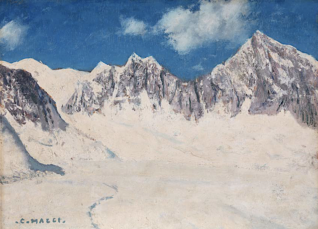
MONT-BLANC DU TACUL PAINTED BY CESARE MAGGI


Cesare Maggi (1881-1961),  Mont-Blanc du Tacul (4,248m -13,937 ft), France, Haute-Savoie,  Alpes, Alpes, Graian Alps Glacier du Géant, Chamonix, France, John Mitchell Gallery, London ,


CESARE MAGGI (1881-1962)
Mont Blanc du Tacul (4,248m -13,937 ft)
France ( Haute-Savoie)

 In Mont Blanc du Tacul seen from the Glacier du Géant, Chamonix, France. oil on panel, 27 x 37cm, courtesy John Mitchell Gallery, London 


The mountain
Mont Blanc du Tacul (4,248m - 13,937 ft) is a mountain in the Mont Blanc massif of the French Alps situated midway between the Aiguille du Midi and Mont Blanc. The Mont Blanc du Tacul looks like a large, snow-covered trapezoid. It is part of the peaks of the Alps over 4,000 meters, of which it is the twenty-fourth highest. To the north of the summit is the Aiguille du Midi, from which it is separated by the Col du Midi (3,532 m), to the south the Mont Maudit, from which it is separated by the Col Maudit (4,035 m), at the is the Aiguilles du Diable then the Glacier du Géant and to the west the Aiguille de Saussure (3,839 m) then the Bossons glacier which rises to its summit. It has a secondary summit, the eastern summit (4,247 m), which is the exit from the Gervasutti pillar. The official first ascent of Mont Blanc du Tacul was by a guideless party comprising Charles Hudson, Edward John Stevenson, Christopher and James Grenville Smith, E. S. Kennedy, Charles Ainslie and G. C. Joad on 8 August 1855. However, Courmayeur guides may have already ascended the peak during their attempts in 1854 and 1855 to force a way up Mont Blanc from the Italian side.

The painter
The italian painter Cesare Maggi was born into a family of actors, Maggi embarked on classical studies at his father’s wish but also took up painting at a very early age His debut in Florence at the Esposizione Annuale della Società di Belle Arti di Firenze in 1898 was followed by a short trip to Paris to catch up with the latest developments.
The crucial turning point in Maggi’s art came in 1889 with the posthumous show of work by Giovanni Segantini held by the Milanese Society of Fine Arts, which prompted a definitive shift to landscape painting of a Divisionist character. After a short stay in the Engadin, he returned to Milan before finally settling in Turin. Commercial collaboration with Alberto Grubicy until 1913 enabled Maggi to establish himself quickly as one of the leading representatives of the second generation of Divisionist painters in Italy. He painted a repertoire of readily comprehensible mountain landscapes focusing primarily on aspects of the visual perception of the reflection of light and colour but lacking the deep spirituality of Segantini’s work. He took part in the major Italian and European exhibitions and the Venice Biennale devoted an entire room to his work at the Esposizione Internazionale d’Arte of Venice in 1912. After an interlude devoted to portrait painting in the same decade, the artist’s mature work focused on greater simplification of subject matter, mostly in landscapes.
Maggi obtained the chair in painting at the Albertina Academy, Turin, in 1936.


___________________________________________
2021- Wandering Vertexes...
by Francis Rousseau

Saturday, December 12, 2020

LA DENT DU GÉANT PAINTED BY MARCEL WIBAULT


https://wanderingvertexes.blogspot.com/2020/12/la-dent-du-geant-painted-by-marcel.html


MARCEL WIBAULT (1904-1998)
La dent du Géant (4,013 m -13,166 ft)
France - Italy


The mountain
The Dent du Géant (4,013 m -13,166 ft) (« Giant's tooth") is a mountain in the Mont Blanc massif in France and Italy. The Dent du Géant remained unclimbed during the golden age of alpinism, and was a much-coveted peak in the 1870s, repelling many parties who attempted it mostly from the Rochefort ridge. In 1880 the strong team of Albert F. Mummery and Alexander Burgener tried to force a passage via the south-west face but were repelled by a band of slabs, causing Mummery to exclaim 'Absolutely inaccessible by fair means!'
The mountain has two summits, (27m-88 ft) apart and separated by a small col :
- Pointe Sella (4,009 m), first ascent via the south-west face by Jean Joseph Maquignaz with son Baptiste Maquignaz and nephew, Daniel Maquignaz on 28 July 1882.
- Pointe Graham (4,013 m), first ascent by W. W. Graham with guides Auguste Cupelin and Alphonse Payot on 20 August 1882.


The artist
Marcel Wibault is a french painter known especially for his numerous paintings of mountains representing Mont-Blanc, Chamonix, the great peaks of the Alps and their "chalets". He made his débuts in art by ketching soldiers of the 60th Infantry Regiment of Besançon. Later he discovered, as a Member of the French Alpine Club, the Alps and its grandiose landscapes. At the start of the 1930s, he settled in Chamonix-Mont-Blanc and discovered, in these troubled times, the departments of Savoie and Haute-Savoie. Encouraged by his wife, Marcel Wibault painted the mountain and its surroundings. Living in Chamonix, he travels the surroundings with his painting equipment. He could produce works in one sitting. Commissioned by the Museum of Natural History and the city of Geneva in Switzerland, as a true knowledgeable geologist, he painted numerous rocks. In the 1960s, he also testified, through his painting, of the construction of the Mont-Blanc Tunnel. Marcel Wibault received many commissions from art lovers and was able to live in part from his art. He was also a teacher for his son Lionel Wibault who, too, is a painter. In his Chamonix chalet, Alpenrose, he made some of his furniture and sculpted many characters. 


Tuesday, November 17, 2020

THE WETTERHORN PAINTED BY ALEXANDRE CALAME

https://wanderingvertexes.blogspot.com/2020/11/the-wetterhorn-painted-by-alexandre.html


ALEXANDRE CALAME (1810-1864)
The Wetterhorn (3,692m-12,113ft)
Switzerland

In "In het Berner Oberland" (1847) Oil on canvas, 78 x 100 cm , Amsterdam Museum


The Mountain
The Wetterhorn (3,692m-12,113ft) in the Bernese Alps, towers above the village of Grindelwald. Formerly known as Hasle Jungfrau, it is one of three summits of a mountain named Wetterhorn sensu lato, or the "Wetterhцrner", the highest summit of which is the Mittelhorn (3,704 m) and the most distant the Rosenhorn (3,689 m). The Mittelhorn and Rosenhorn are mostly hidden from view from Grindelwald. The Grosse Scheidegg Pass crosses the col to the north, between the Wetterhorn and the Schwarzhorn.
Climbing
The Wetterhorn summit was first reached on August 31, 1844, by the Grindelwald guides Hans Jaun and Melchior Bannholzer, three days after they had co-guided a large party organized by the geologist Edouard Desor to the first ascent of the Rosenhorn. The Mittelhorn was first summitted on 9 July 1845 by the same guides, this time accompanied by a third guide, Kaspar Abplanalp, and by Stanhope Templeman Speer. The son of a Scottish physician, Speer lived in Interlaken, Switzerland.
A September 1854 ascent by a party including Alfred Wills is much celebrated in Great Britain. Apparently believing to be the first ascendant, Wills' description of this trip in his book "Wanderings Among the High Alps" (published in 1856) helped make mountaineering fashionable in Britain and ushered in the systematic exploration of the Alps by British mountaineers, the so-called golden age of alpinism.  Despite several well-documented earlier ascents and the fact that he was guided to the top, even in his obituary in 1912 he was considered to be "certainly the first who can be said with any confidence to have stood upon the real highest peak of the Wetterhorn proper" (i.e. the 3,692 m summit).  In a subsequent corrigendum, the editors admitted two earlier ascents, but considered his still "the first completely successful" one.
In 1866, Lucy Walker was the first documented female ascendant of the peak.
The 24-year-old English mountaineer William Penhall and his Meiringen guide Andreas Maurer were killed by an avalanche high up on the Wetterhorn on 3 August 1882.
The famed guide and Grindelwald native Christian Almer climbed the mountain many times in his life, including on his first of many trips with Meta Brevoort and her nephew W. A. B. Coolidge in 1868. His last ascent was in 1898 at the age of 70 together with his wife to celebrate their golden anniversary on top.  Winston Churchill is also supposed  to have climbed the Wetterhorn in 1894.

The painter
Alexandre Calame was a Swiss painter. He was the son of a skillful marble worker in Vevey. His father lost the family fortune, and Alexandre Calame was forced to work in a bank at the age of 15. When his father fell from a building and then died, the young Calame provided for his mother.
In his spare time he began to practice drawing small views of Switzerland. In 1829 he met his patron, the banker Diodati, who made it possible for him to study under landscape painter François Diday. After a few months he decided to devote himself fully to art.
In 1835, he began exhibiting his Swiss-Alps and forest paintings in Paris and Berlin. He became quite well known, especially in Germany, although Calame was more a drawer than an illustrator. He is associated with the Dusseldorf school of painting. In 1842 he went to Paris and displayed his works Mont Blanc, the Jungfrau, the Brienzersee, the Monte Rosa and Mont Cervin. He taught in Geneva, where Adolf Mosengel was one of his pupils.
He went to Italy in 1844 and brought back from Rome and Naples countless paintings, among them one of the ruins of Paestum (in the city museum in Leipzig). He showed that he was capable of understanding Italian nature; but the Alps remained his speciality.
The glaciers, emerald-green, white foaming mountain water, which split the trees during the storm, and the whipped clouds, the multi-colored rocks, half masked from fog, in the rays of the gleaming sun, are those things, which he knew to be true to nature.
One of his most ingenious works is the representation of the four seasons and times of the day in four landscapes, a spring morning in the south, a summer midday in the Nordic flatlands, an Autumn evening, and a winter night on a mountain. He became popular with these large works, and his popularity grew with smaller pieces and lithographies, namely 18 studies of Lauterbrunnen and Meiringen and the 24 sheets of Alpine passes. These were widespread in France, England, and Germany and are still today used to teach this style of painting.
He died in Menton, France in 1864. An exhibition featuring more than thirty of Calame's paintings was held at the Sterling and Francine Clark Art Institute in Williamstown, Massachusetts in 2006.

______________________________
2020 - Wandering Vertexes...
by Francis Rousseau