google.com, pub-0288379932320714, DIRECT, f08c47fec0942fa0 GRAVIR LES MONTAGNES... EN PEINTURE: INSELBERG
Showing posts with label INSELBERG. Show all posts

Tuesday, March 12, 2024

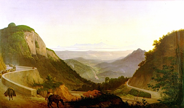
PICO DE MARIA COMPRIDA PEINT PAR AGOSTINHO JOSE DA MOTA

AGOSTINHO JOSE DA MOTA (1824-1878) Pico de Maria Comprida (1926 me Brésil   In Paisagem do Rio de Janeiro, huile sur toile, 130 x 79cm

AGOSTINHO JOSE DA MOTA (1824-1878)
Pico de Maria Comprida (1,926 m)
Brésil

 In Paisagem do Rio de Janeiro, huile sur toile, 130 x 79cm

 
La montagne

Le Pico da Maria Comprida (1,926m) est connu parmi les grimpeurs brésiliens pour abriter la voie d'escalade Maria Nebulosa , qui fut également la première voie du pays avec plus de 1000 mètres de longueur. Avec la nouvelle zone de protection, les habitants de la région et les alpinistes prévoient d'explorer ces attractions de manière durable et de promouvoir ainsi l'écotourisme et le tourisme rural dans la région.

Le peintre
Agostinho José da Mota était peintre, dessinateur et professeur brésilien. Ainsi, en 1837, il s'inscrit à l'Académie Impériale des Beaux-Arts. Il fut un brillant élève et, pour ses mérites et ses compétences démontrés, il reçut le prix d'un voyage en Europe en 1850. De retour au Brésil, en 1856, il est l'un des fondateurs de la Société de propagation des beaux-arts de Rio de Janeiro. Deux ans plus tard, il peint les portraits du couple impérial - Dom Pedro II (1825 - 1891) et Dona Teresa Cristina (1822 - 1889). La majeure partie de la production artistique d'Agostinho de Motta est constituée de paysages et de natures mortes. Sa représentation du paysage brésilien est parmi les meilleures qui impriment les valeurs et les normes de l'Académie Impériale des Beaux-Arts (AIBA), dans laquelle il a étudié et a ensuite été professeur, tant dans la formation de l'idée d'image nationale que comme dans la formation de l’image de l’empire. Agostinho Mota l'a fait pour ses œuvres artistiques, comme le portrait du couple impérial et les archives de la scène de l'époque.Les paysages d'Agostinho Motta sont les œuvres les plus célèbres de l'artiste. Ils se distinguent par la précision topographique, par le registre exact des dimensions des scénarios et par la compétence avec laquelle ils capturent les transpositions entre les différentes couleurs qui constituent ses extérieurs travaillés. Les scénarios choisis par l'artiste démontrent la dimension marquée de l'identité nationale qu'Agostinho Mota entendait représenter dans ses peintures, comme le Paysage de Rio de Janeiro, ci dessus influencé par les canons de l'AIBA.

 ________________________________________

2011-2024 - Gravir les montagnes en peinture
Un blog de Francis Rousseau  


Saturday, July 23, 2022

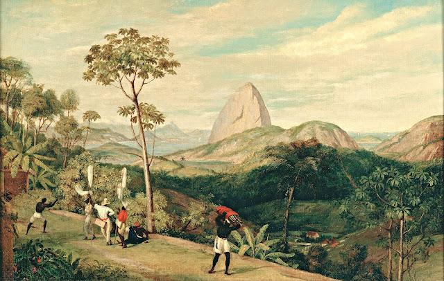
PAO DE AÇUCAR PAINTED BY CHARLES LANDEER


CHARLES LANDEER (1799-1879) Pao de Açucar / Sugarloaf Mountain / (396 m - 1299 ft) Brazil  In  "View of Sugarloaf Mountain from the Silvestre Road 1827, oil on canvas,  61,5x91 cm, Pinacoteca do Estado de São Paulo, Brazil

CHARLES LANDEER (1799-1879)
Pao de Açucar / Sugarloaf Mountain / (396 m - 1299 ft)
Brazil

In View of Sugarloaf Mountain from the Silvestre Road 1827, oil on canvas, 61,5 x 91 cm,
Pinacoteca do Estado de São Paulo, Brazil


The painter
Charles Landseer (RA) was an English painter, mostly of historical subjects. He was born the second son of the engraver John Landseer, and the elder brother of the animal painter, Sir Edwin Landseer. He trained under his father, and the painter Benjamin Robert Haydon. He was awarded the silver palette of the Royal Society of Arts for a drawing of Laocoon in 1815, and in 1816 he entered the Royal Academy Schools where he was taught by Henry Fuseli. In 1823 he accompanied Sir Charles Stuart de Rothesay on a diplomatic mission to Portugal and Brazil. Many of the drawings he made on the journey were shown at the British Institution in 1828. He became an associate in of the Royal Academy in 1837, and a full academician in 1845. In 1851, he was appointed Keeper of the Royal Academy, a post requiring him to teach in the "Antique School". He remained in the position until 1873.  Most of his pictures were of subjects from British history, or from literature. He paid close attention to the historical accuracy of the accessories and details in his paintings. His works included The Meeting of Charles I. and his Adherents before the Battle of Edgehill, Clarissa Harlowe in the Prison Room of the Sheriff's Office (1833, now in the collection of the Tate Gallery), The Pillaging of a Jew's House in the Reign of Richard I (1839, Tate Gallery) and The Temptation of Andrew Marvel (1841). While under Haydon's instruction he also made a series of detailed anatomical drawings.  He died in London on 22 July 1879, leaving  quite generously 10,000 guineas to the Royal Academy to fund scholarships.

The mountain
Sugarloaf Mountain (396 m - 1299 ft), Pao de Açucar in Portuguese, Pain de Sucre in French, is a isolated peak (Inselberg) situated in Rio de Janeiro, Brazil, at the mouth of Guanabara Bay on a peninsula that sticks out into the Atlantic Ocean. Rising above the harbor, its name is said to refer to its resemblance to the traditional shape of concentrated refined loaf sugar. It is known worldwide for its cableway and panoramic views of the city. The name "Sugarloaf" was coined in the 16th century by the Portuguese during the heyday of sugar cane trade in Brazil. According to historian Vieira Fazenda, blocks of sugar were placed in conical molds made of clay to be transported on ships. The shape given by these molds was similar to the peak, hence the name.
Climbing routes:
1907 – The Brazilian engineer Augusto Ferreira Ramos had the idea of linking the hills through a path in the air.
1910 – The same engineer founded the Society of Sugar Loaf and the same year the works were started. The project was commissioned in Germany and built by Brazilian workers. All parts were taken by climbing mountains or lift by steel cables.
1912 – Opening of the tram. First lift of Brazil. The first cable cars were made of coated wood and were used for 60 years.
1972 – The current template trolley was put into operation. This increased the carrying capacity by almost ten times.
2009 – Inauguration of the next generation of cable cars that had already been purchased and are on display at the base of Red Beach.
Visitors can watch rock climbers on Sugarloaf and the other two mountains in the area: Morro da Babilônia (Babylon Mountain), and Morro da Urca (Urca's Mountain). Together, they form one of the largest urban climbing areas in the world, with more than 270 routes, between 1 and 10 pitches long.

Tuesday, May 31, 2022

ULURU / AYERS ROCKS PHOTOGRAPHED IN 1894 BY WALTER BALDWIN SPENCER


WALTER BALDWIN SPENCER (1860-1929) Uluru /Ayers Rock (863 m -2,831 ft) Australia (Northern Territory)   In  Uluru, Ayers Rock, central Australia, 1894,  Glass plate negative 80 mm x 106 mm, Museums Victoria

WALTER BALDWIN SPENCER (1860-1929)
Uluru /Ayers Rock (863 m -2,831 ft)
Australia (Northern Territory)


In Uluru, Ayers Rock, central Australia, 1894, Glass plate negative 80 mm x 106 mm, 
Museums Victoria


The artist
Sir Walter Baldwin Spencer commonly referred to as Baldwin Spencer, was a British-Australian evolutionary biologist, anthropologist and ethnologist. He is known for his fieldwork with Aboriginal peoples in Central Australia, contributions to the study of ethnography, and academic collaborations with Frank Gillen. Spencer introduced the study of zoology at the University of Melbourne and held the title of Emeritus Professor until his death in 1929.In 1894 a new field was opened up for Spencer when he joined the W.A. Horn scientific expedition which left Adelaide in May 1894 to explore Australia. Spencer paid two more visits to the centre of Australia, one in 1923 with Dr Leonard Keith Ward, the government geologist of South Australia, and the other in 1926. These visits enabled Spencer to revise his earlier researches and consider on the spot various opposing theories that had been brought forward. His The Arunta: a Study of a Stone Age People (1927), revisits and reaffirms his earlier conclusions; Gillen's name as joint author appeared on the title-page though he had died 15 years before. Wanderings in Wild Australia, published a year later and slightly more popular in form, completes the list of his books. A list of his other published writings will be found in Spencer's Last Journey (1931). Spencer went to London in 1927 to see these books through the press. Ten years before he had said that he realised he was not getting younger and must regard his field work as finished. In February 1929, however, in his sixty-ninth year, he travelled in a cargo boat to Magallanes and then went in a little schooner to Ushuaia at the south of Tierra del Fuego. 


The mountain 
Uluru (863m -2,831 ft) also known as Ayers Rock (in honour of the then Chief Secretary of South AustraliaSir Henry Ayers) is a large sandstone rock formation in the southern part of the Northern Territory in central Australia.   Officially  the rock is gazetted as "Uluru / Ayers Rock". 
It lies 335 km (208 mi) south west of the nearest large town, Alice Springs, 450 km (280 mi) by road.
Kata Tjuta and Uluru are the two major features of the Uluṟu-Kata Tjuṯa National Park. Uluru is sacred to the Pitjantjatjara Anangu, the Aboriginal people of the area. The area around the formation is home to an abundance of springs, waterholes, rock caves, and ancient paintings.  Both Uluru and the nearby Kata Tjuta formation have great cultural significance for the Aṉangu people, the traditional inhabitants of the area, who lead walking tours to inform visitors about the local flora and fauna, bush food and the Aboriginal dreamtime stories of the area.
Uluru is notable for appearing to change colour at different times of the day and year, most notably when it glows red at dawn and sunset.
Uluru is listed as a UNESCO World Heritage Site.
Uluru is an inselberg, literally "island mountain"An inselberg is a prominent isolated residual knob or hill that rises abruptly from and is surrounded by extensive and relatively flat erosion lowlands in a hot, dry region.  Uluru is also often referred to as a monolith, although this is a somewhat ambiguous term that is generally avoided by geologists. The remarkable feature of Uluru is its homogeneity and lack of jointing and parting at bedding surfaces, leading to the lack of development of scree slopes and soil. These characteristics led to its survival, while the surrounding rocks were eroded. For the purpose of mapping and describing the geological history of the area, geologists refer to the rock strata making up Uluru as the Mutitjulu Arkose, and it is one of many sedimentary formations filling the Amadeus Basin.
According to the Aṉangu, traditional landowners of Uluru: 
The world was once a featureless place. None of the places we know existed until creator beings, in the forms of people, plants and animals, traveled widely across the land. Then, in a process of creation and destruction, they formed the landscape as we know it today. Aṉangu land is still inhabited by the spirits of dozens of these ancestral creator beings which are referred to as Tjukuritja or Waparitja.
There are a number of differing accounts given, by outsiders, of Aboriginal ancestral stories for the origins of Uluru and its many cracks and fissures. One such account, taken from Robert Layton's (1989) Uluru: An Aboriginal history of Ayers Rock, reads as follows:
Uluru was built up during the creation period by two boys who played in the mud after rain. When they had finished their game they travelled south to Wiputa ... Fighting together, the two boys made their way to the table topped Mount Conner, on top of which their bodies are preserved as boulders. 
Two other accounts are given in Norbert Brockman's (1997) Encyclopedia of Sacred Places.
The first tells of serpent beings who waged many wars around Uluru, scarring the rock. The second tells of two tribes of ancestral spirits who were invited to a feast, but were distracted by the beautiful Sleepy Lizard Women and did not show up. In response, the angry hosts sang evil into a mud sculpture that came to life as the dingo. There followed a great battle, which ended in the deaths of the leaders of both tribes. The earth itself rose up in grief at the bloodshed, becoming Uluru.
The Commonwealth Department of Environment's webpage advises:
Many...Tjukurpa such as Kalaya (Emu), Liru (poisonous snake), Lungkata (blue tongue lizard), Luunpa (kingfisher) and Tjintir-tjintirpa (willie wagtail) travel through Uluṟu-Kata Tjuṯa National Park. Other Tjukurpa affect only one specific area.
Kuniya, the woma python, lived in the rocks at Uluru where she fought the Liru, the poisonous snake.
It is sometimes reported that those who take rocks from the formation will be cursed and suffer misfortune. There have been many instances where people who removed such rocks attempted to mail them back to various agencies in an attempt to remove the perceived curse.

__________________________________________
2022 - Wandering Vertexes...
by Francis Rousseau

Sunday, March 8, 2020

MOUNT TABOR BY CATHERINE TOBIN


CATHERINE TOBIN (1855-1903)
Mount Tabor (575 m -1,886 ft)
Israel (Galilee)
In  Mont Tabor, engraving, Israel British Library
 
The mountain
Mount Tabor (575 m - 1,886 ft), (not to be confused with Mount Thabor int he French Alps) is located in Lower Galilee, Israel, at the eastern end of the Jezreel Valley, 11 miles (18 km) west of the Sea of Galilee. Mount Tabor is a Inselberg : an isolated hill or small mountain rising abruptly from gently sloping or level surrounding land, and is not volcanic.
In the Hebrew Bible (Joshua, Judges), Mount Tabor is the site of the Battle of Mount Tabor between the Israelite army under the leadership of Barak and the army of the Canaanite king of Hazor, Jabin, commanded by Sisera.
In Christian tradition, Mount Tabor is the site of the Transfiguration of Jesus.
Mount Tabor is shaped almost like half a sphere, suddenly rising from rather flat surroundings and dominating the town in the plain below, Kfar Tavor. At the top of the mountain are two Christian monasteries, one Greek Orthodox on the northeast side and one Roman Catholic on the southeast side. The Catholic church at the top is easily visible from afar.
At the base it is almost fully surrounded by the Arab villages of Daburiyya, Shibli, and Umm al-Ghanam. Mount Tabor is located off Highway 65, and its summit is accessible by road via Shibli. A hiking tracks starts from the Bedouin village Shibli and is about five kilometers long. It is part of the Israel National Trail.

The artist
Catherine Tobin (died 1903) was a Victorian era author and artist who travelled with her husband and wrote books around the experiences as well as translator for a book on the area. She married Thomas Tobin on 12 September 1835 and with whom she had one son.  However Tobin and her husband shared an interest in travel and antiquities and spent considerable time in the middle and near east. She wrote a number of books due to this interest and travel as well as translating another. At home in Cork, Tobin was a patron of the South Infirmary Victoria University Hospitalfor many years.
George Kelleher has suggested that while Thomas Tobin was an 'antiquarian and curio collector in the spirit of the Victorian age', his wife Catherine, 'was a far more considerable cultural figure'. Her work has served as the basis for a number of studies about the regions.

_____________________________

2020 - Wandering Vertexes...
by Francis Rousseau

Wednesday, February 19, 2020

ULURU / AYERS ROCK (2) PAINTED BY PETER TAYLOR TJUTJATJA


PETER TAYLOR TJUTJATJA (1940-2014)
Uluru /Ayers Rock (863m -2,831 ft)
Australia (Northern Territory) 

In Uluru, Watercolor on Archer Paper, 56 x 37 cm,  Central arborigenal Art, Australia

The mountain 
 Uluru (863m - 2,831 ft) also known as Ayers Rock (in honour of the then Chief Secretary of South Australia, Sir Henry Ayers) is a large sandstone rock formation in the southern part of the Northern Territory in central Australia.
Officially the rock is gazetted as "Uluru / Ayers Rock"
It lies 335 km (208 mi) south west of the nearest large town, Alice Springs, 450 km (280 mi) by road.
Kata Tjuta and Uluru are the two major features of the Uluṟu-Kata Tjuṯa National Park. Uluru is sacred to the Pitjantjatjara Anangu, the Aboriginal people of the area. The area around the formation is home to an abundance of springs, waterholes, rock caves, and ancient paintings. Both Uluru and the nearby Kata Tjuta formation have great cultural significance for the Aṉangu people, the traditional inhabitants of the area, who lead walking tours to inform visitors about the local flora and fauna, bush food and the Aboriginal dreamtime stories of the area.
Uluru is notable for appearing to change colour at different times of the day and year, most notably when it glows red at dawn and sunset.
Uluru is listed as a UNESCO World Heritage Site.
More about Uluru

The painter
The painter Peter Taylor Tjutjatja was born at Oodnadatta, south-east of Alice Springs, in the Simpson Desert. As a small boy he travelled with his father often by camel or horse, to Horseshoe Bend Station, where his father worked as a station-hand. From there they travelled north working from station to station until they came to Hermannsburg, a Western Arrernte community in the MacDonnell Ranges, west of Alice Springs.
Hermannsburg in central Australia is the homeland of Albert Namatjira - the most famous Aboriginal painter of all time. Peter, as a small boy living in Hermannsburg was influenced by Albert Namatjira's central desert landscapes. While attending school in Adelaide, Peter showed an interest in drawing and his skills were further developed by his art teacher Trevor Clare.
More about the painter 

_________________________________________

2020 - Wandering Vertexes...
by Francis Rousseau

Wednesday, January 1, 2020

MOUNT TABOR BY BARONESS HELGA VON CRAMM


BARONESS HELGA VON CRAMM (1840-1919)
Mount Tabor (575 m -1,886 ft)
Israel (Galilee)

In Happy New Year from Mont Tabor, New year chromolithographic card.

The mountain
Mount Tabor (575 m - 1,886 ft), (not to be confused with Mount Thabor int he French Alps ) is located in Lower Galilee, Israel, at the eastern end of the Jezreel Valley, 11 miles (18 km) west of the Sea of Galilee. Mount Tabor is a Inselberg : an isolated hill or small mountain rising abruptly from gently sloping or level surrounding land, and is not volcanic.
In the Hebrew Bible (Joshua, Judges), Mount Tabor is the site of the Battle of Mount Tabor between the Israelite army under the leadership of Barak and the army of the Canaanite king of Hazor, Jabin, commanded by Sisera.
In Christian tradition, Mount Tabor is the site of the Transfiguration of Jesus.
Mount Tabor is shaped almost like half a sphere, suddenly rising from rather flat surroundings and dominating the town in the plain below, Kfar Tavor. At the top of the mountain are two Christian monasteries, one Greek Orthodox on the northeast side and one Roman Catholic on the southeast side. The Catholic church at the top is easily visible from afar.
At the base it is almost fully surrounded by the Arab villages of Daburiyya, Shibli, and Umm al-Ghanam. Mount Tabor is located off Highway 65, and its summit is accessible by road via Shibli. A hiking tracks starts from the Bedouin village Shibli and is about five kilometers long. It is part of the Israel National Trail.

The artist
Baroness Helga von Cramm was a German and Swiss water-colourist and graphic artist. She made her quite famous with her in chromolithograh Christmas cards. Helga von Cramm lived in Britain, Switzerland (St. Moritz), Germany and Italy, and Florence.
Helga was the eldest child of Wolf Frederick Adolf Freiherr von Cramm-Burchard Helga's father, having been brought up in the Court at Brunswick, educated at the court of knights, served in the Brunswick Cuirassiers , was an equerry and an hereditary Chamberlain and Lord of the Kings Bedchamber (that of William VIII of Braunschweig). Later he retired to his estate at Rhode. Her brother Aschwin Thedel Adelbert Freiherr v. Sierstorpff-Cramm, is one of the four great-grandfathers of Queen Beatrix of the Netherlands, now Princess Beatrix, and mother of the present king, Willem-Alexander. Helga was thus a great-great aunt of the former Dutch Queen.
In the United Kingdom, from 1877, she exhibited at the : Society of Women Artists, Royal Scottish Academy, Royal Institute of Painters in Water Colours, Dudley Gallery, Fine Art Society, Glasgow Institute,Grosvenor Gallery, Royal Hibernian Academy of Arts ,Royal Society of British Artists and at a few other places...

_______________________________
2020 - Wandering Vertexes...
by Francis Rousseau


Thursday, December 5, 2019

MOUNT TABOR PAINTED BY ANSELM KIEFFER


ANSELM KIEFER (bn.1945)
Mount Tabor (575 m -1,886 ft)
Israel (Galilee)

In Mount Tabor, 2009) Oil, emulsion, acrylic, and shellac on canvas. 149 cmx 149 cm 
Courtesy  Gagosian Gallery

The mountain
Mount Tabor (575 m - 1,886 ft), (not to be confused with Mount Thabor int he French Alps ) is located in Lower Galilee, Israel, at the eastern end of the Jezreel Valley, 11 miles (18 km) west of the Sea of Galilee. Mount Tabor is a Inselberg : an isolated hill or small mountain rising abruptly from gently sloping or level surrounding land, and is not volcanic.
In the Hebrew Bible (Joshua, Judges), Mount Tabor is the site of the Battle of Mount Tabor between the Israelite army under the leadership of Barak and the army of the Canaanite king of Hazor, Jabin, commanded by Sisera.
In Christian tradition, Mount Tabor is the site of the Transfiguration of Jesus.
Mount Tabor is shaped almost like half a sphere, suddenly rising from rather flat surroundings and dominating the town in the plain below, Kfar Tavor. At the top of the mountain are two Christian monasteries, one Greek Orthodox on the northeast side and one Roman Catholic on the southeast side. The Catholic church at the top is easily visible from afar.
At the base it is almost fully surrounded by the Arab villages of Daburiyya, Shibli, and Umm al-Ghanam. Mount Tabor is located off Highway 65, and its summit is accessible by road via Shibli. A hiking tracks starts from the Bedouin village Shibli and is about five kilometers long. It is part of the Israel National Trail.

The painter 
Anselm Kiefer (born 8 March 1945) is a German painter and sculptor. He studied with Joseph Beuys and Peter Dreher during the 1970s. His works incorporate materials such as straw, ash, clay, lead, and shellac. The poems of Paul Celan have played a role in developing Kiefer's themes of German history and the horror of the Holocaust, as have the spiritual concepts of Kabbalah.
In his entire body of work, Kiefer argues with the past and addresses taboo and controversial issues from recent history. Themes from Nazi rule are particularly reflected in his work; for instance, the painting "Margarethe" (oil and straw on canvas) was inspired by Paul Celan's well-known poem "Todesfuge" ("Death Fugue").
His works are characterised by an unflinching willingness to confront his culture's dark past, and unrealised potential, in works that are often done on a large, confrontational scale well suited to the subjects. It is also characteristic of his work to find signatures and/or names of people of historical importance, legendary figures or historical places. All of these are encoded sigils through which Kiefer seeks to process the past; this has resulted in his work being linked with the movements New Symbolism and Neo–Expressionism.
Kiefer has lived and worked in France since 1992. Since 2008, he has lived and worked primarily in Paris and in Alcácer do Sal, Portugal.
 In 2018, he was awarded Austrian citizenship.

___________________________________________
2019 - Wandering Vertexes...
by Francis Rousseau

Wednesday, October 16, 2019

MOUNT TABOR BY JACOB PEETERS


JACOB PEETERS (1637-1695)
Mount Tabor (575 m -1,886 ft)
Israel (Galilee)

In Den bergh Thabor in Palestynen, 1692, engraving from World Atlas

The mountain 
Mount Tabor  (575 m - 1,886 ft), (not to be confused with Mount Thabor int he French Alps ) is located in Lower Galilee, Israel, at the eastern end of the Jezreel Valley, 11 miles (18 km) west of the Sea of Galilee.  Mount Tabor is a Inselberg : an isolated hill or small mountain rising abruptly from gently sloping or level surrounding land, and is not volcanic.
In the Hebrew Bible (Joshua, Judges), Mount Tabor is the site of the Battle of Mount Tabor between the Israelite army under the leadership of Barak and the army of the Canaanite king of Hazor, Jabin, commanded by Sisera.
In Christian tradition, Mount Tabor is the site of the Transfiguration of Jesus.
Mount Tabor is shaped almost like half a sphere, suddenly rising from rather flat surroundings and dominating  the town in the plain below, Kfar Tavor. At the top of the mountain are two Christian monasteries, one Greek Orthodox on the northeast side and one Roman Catholic on the southeast side. The Catholic church at the top is easily visible from afar.
At the base it is almost fully surrounded by the Arab villages of Daburiyya, Shibli, and Umm al-Ghanam. Mount Tabor is located off Highway 65, and its summit is accessible by road via Shibli. A hiking tracks starts from the Bedouin village Shibli and is about five kilometers long. It is part of the Israel National Trail.

The artist
Flemish engraver and book-seller, Jacob Peeters (1637-1695) was descended from a family of artists. He kept a shop in Antwerp, where he “sold every kind of prints and engravings, small and larger geographical maps, drawn in ink, coloured, as well as of a larger size...”
Peeters is known mainly for his “World Atlas”, published in 1692.
The album forms part of a series of dithyrambic publications, which exalted the brilliant victories of the Venetians on the Ottomans. Similar books were published by the Accademia Cosmografica degli Argonauti, which had been founded by Vincenzo Coronelli.
The plates of the edition were based on drawings by Jacob Peeters' brother, Johannes or Jan Peeters (1625-1677), who made several views of cities, later etched by Merian. Johannes was a pupil of their older brother, Bonaventura Peeters, also a very well-known painter who specialized in seascapes.
Most of the plates were etched by Gaspar Bouttats (1640-1695), a well-known books merchant and engraving master. The description of each city and subject is given at the beginning of the edition, while each copy of the work includes a different number of plates. There are plates showing locations, cities and ports at Montenegro, Albania, Croatia, the Ionian and Aegean seas, Central Greece (the Peloponnese, Attica and Thessaly), Asia Minor, Syria, Cyprus, the Holy Land, Turkey, Yemen, Irak, Armenia, the Caspian Sea and other places all the way to Iran and India...

_______________________________
2019 - Wandering Vertexes...
by Francis Rousseau

Thursday, August 22, 2019

MOUNT TABOR BY CORNELIUS DE BRUYN


CORNELIUS DE BRUYN (1652-1726)
Mount Tabor  (575 m -1,886 ft)
Israel  (Galilee)

 In Montagne de Thabor, Voyages au levant, 1714


The mountain 
Mount Tabor  (575 m - 1,886 ft), (not to be confused with Mount Thabor int he French Alps ) is located in Lower Galilee, Israel, at the eastern end of the Jezreel Valley, 11 miles (18 km) west of the Sea of Galilee.  Mount Tabor is a Inselberg : an isolated hill or small mountain rising abruptly from gently sloping or level surrounding land, and is not volcanic.
In the Hebrew Bible (Joshua, Judges), Mount Tabor is the site of the Battle of Mount Tabor between the Israelite army under the leadership of Barak and the army of the Canaanite king of Hazor, Jabin, commanded by Sisera.
In Christian tradition, Mount Tabor is the site of the Transfiguration of Jesus.
Mount Tabor is shaped almost like half a sphere, suddenly rising from rather flat surroundings and dominating  the town in the plain below, Kfar Tavor. At the top of the mountain are two Christian monasteries, one Greek Orthodox on the northeast side and one Roman Catholic on the southeast side. The Catholic church at the top is easily visible from afar.
At the base it is almost fully surrounded by the Arab villages of Daburiyya, Shibli, and Umm al-Ghanam. Mount Tabor is located off Highway 65, and its summit is accessible by road via Shibli. A hiking tracks starts from the Bedouin village Shibli and is about five kilometers long. It is part of the Israel National Trail.

The artist
Cornelius de Bruyn, (also called Cornelis de Bruijn) was a Dutch artist and traveler. He made two large tours and published illustrated books with his observations of people, buildings, plants and animals.
During his first tour, he visited Rome. He travelled in Egypt and climbed to the top of a pyramid where he left his signature. De Bruijn made secret drawings of Jerusalem, then part of the Ottoman Empire. His drawings of Palmyra are copies. De Bruijn reached Cyprus and stayed among the Dutch merchants in Smyrna and Constantinople.
From 1684 he worked in Venice with the painter Johann Carl Loth, returning in 1693 to The Hague, where he sold his souvenirs. In 1698 he published his book with drawings, which was a success and was translated in several languages. Two examples have colored illustrations, the first color prints in history. Among his drawings were the first pictures of the interior of the Great Pyramid and Jerusalem that became known in Europe.
In 1701 he headed for Archangelsk. During his second tour he visited the Samoyeds in northern Russia. In Moscow he became acquainted with emperor Peter the Great: de Bruijn painted his nieces, and the paintings were sent to possible candidates for marriage.
In late April 1703, De Brujin left Moscow along with the party of an Armenian merchants from Isfahan whose name he recorded as Jacob Daviedof.  De Bruijin and the Armenians sailed down the Moscow River, the Oka and the Volga, eventually reaching Astrakhan. Thanks to de Bruijn's short stopover in Nizhny Novgorod during the Easter holidays, we now have his description of that major center of the Russian Volga trade as it existed in 1703, with its Kremlin, stone churches, and a lively bar (kabak) scene.
Leaving the borders of the Russian state, de Brujin arrived to Persia, where he made drawings of towns like Isfahan and Persepolis (1704–1705). He continued to Java and returned to Persia, Russia, and ultimately the Netherlands.
His drawings of Persepolis, a city destroyed by Alexander the Great, caused a sensation. The mayor of Amsterdam Nicolaes Witsen and a member of the Royal Society probably asked him to draw the city famous for its 40 columns. For a century, they were the best prints available to western scholars. De Bruijn was accused of plagiarism and his second book, Reizen over Moskovie was not such a success. From Amsterdam he fled to Vianen.
De Bruijn died in Utrecht. It is not known when and where he was buried.
De Bruijn, who had read every Greek and Latin source he had been able to obtain, displays a convincing knowledge of subjects, at times going into the humorous. In Persia, he obtained a copy of Firdausi's Shahnamê, which he summarized and made accessible to the west.
___________________________________________
2019 - Wandering Vertexes...
by Francis Rousseau 

Saturday, July 13, 2019

MOUNT DISCOVERY (2) BY EDWARD ADRIAN WILSON


EDWARD ADRIAN WILSON (1872-912)
Mount Discovery (2, 681m - 8,796 ft)
Antarctica

In The Last Sight of Mount Discovery, watercolour on paper (12.1 x 20.6cm.), 1904, Private owner 

About this painting
"And so that night [19 February 1904], running swiftly through the water with a howling gale behind, we saw the last of the McMurdo Sound. It was a fine scene, for although the wind blew with great force, the sky was comparatively clear. Away to the south-west behind the ragged storm clouds could be seen the deep red of the setting sun, against which there stood in sharp outline the dark forms of the western mountains and the familiar cone of Mount Discovery. On our right in a gloomy threatening sky rose the lofty snow-clad slopes of Erebus and the high domed summit of Cape Bird. For the last time we gazed at all these well-known landmarks with feelings that were not far removed from sadness...'
(R.F. Scott, The Voyage of the 'Discovery', London: 1907, II, pp.274-5).

The mountain
Mount Discovery (2, 681m - 8,796 ft) is a conspicuous, isolated stratovolcano, lying at the head of McMurdo Sound and east of Koettlitz Glacier, overlooking the NW portion of the Ross Ice Shelf. It forms the center of a three-armed mass of which Brown Peninsula is one extension to the north; Minna Bluff is a second to the east; the third is Mount Morning to the west. It was discovered by the Discovery British National Antarctic Expedition (1901-1904) and named for their expedition ship Discovery.

The artist
Edward Adrian Wilson, nicknamed "Uncle Bill" was an English physician, polar explorer, natural historian, painter and ornithologist. Wilson took part in two British expeditions to Antarctica, the Discovery Expedition (1901-1904) and the tragic Terra Nova Expedition (1907-1912), both under the leadership of Scott.
Dr. Edward A. Wilson is widely regarded as one of the finest artists ever to have worked in the Antarctic. Sailing with Captain Scott aboard 'Discovery' (1901-1904), he became the last in a long tradition of 'exploration artists' from an age when pencil and water-colour were the main methods of producing accurate scientific records of new lands and animal species. He combined scientific, topographical and landscape techniques to produce accurate and beautiful images of the last unknown continent. Such was the strength of his work that it also helped to found the tradition of modern wildlife painting. In particular Wilson captured the essence of the flight and motion of Southern Ocean sea-birds on paper.
Returning with Captain Scott aboard 'Terra Nova' (1910-1913) as Chief of Scientific Staff, he continued to record the continent and its wildlife with extraordinary deftness. Chosen to accompany Captain Scott to the South Pole, his last drawings are from one of the most famous epic journeys in exploration history. Along with his scientific work, Wilson's pencil recorded the finding of Roald Amundsen's tent at the South Pole by Captain Scott. Wilson died, along with the other members of the British Pole Party, during the return journey, in March 1912. The drawings and paintings were created at considerable personal cost in the freezing conditions in which Wilson worked. He often suffered severely from the cold whilst sketching and also from snow-blindness, or sunburn of the eye. They provide a remarkable testament to one of the great figures of the heroic age of Antarctic exploration. The book has been produced as a companion volume to 'Edward Wilson's Nature Notebooks' by two of Wilson's great nephews, to mark the centenary of his death.

2019 - Wandering Vertexes...
Un blog de Francis Rousseau


Thursday, February 21, 2019

PAO DA AÇUCAR BY AGOSTINHO JOSE DA MOTA


AGOSTINHO JOSE DA MOTA (1824-1878)
 Pao de Açucar  / Sugarloaf mountain  (396 m - 1,299 ft)
Brazil

In  Vista da Gambo no Rio de Janeiro,1852, oil on canvas 

The mountain
Pao de Açucar  (396 m - 1299ft), Sugarloaf Mountain in english, Pain de Sucre in French,  is a isolated peak (Inselberg) situated in Rio de Janeiro, Brazil, at the mouth of Guanabara Bay on a peninsula that sticks out into the Atlantic Ocean. Rising above the harbor, its name is said to refer to its resemblance to the traditional shape of concentrated refined loaf sugar. It is known worldwide for its cableway and panoramic views of the city. The name "Sugarloaf" was coined in the 16th century by the Portuguese during the heyday of sugar cane trade in Brazil. According to historian Vieira Fazenda, blocks of sugar were placed in conical molds made of clay to be transported on ships. The shape given by these molds was similar to the peak, hence the name.

The painter 
Agostinho José da Mota was a painter, draftsman and Brazilian professor. Thus, in 1837, enrolled in the Imperial Academy of Fine Arts. He was a brilliant student and for the merits and competence demonstrated, received the prize for a trip to Europe, in 1850. Returning to Brazil, in 1856, he is one of the founders of the Society Propagating Fine Arts of Rio de Janeiro. Two years later, he  painted the portraits of the imperial couple - Dom Pedro II (1825 - 1891) and Dona Teresa Cristina (1822 - 1889).
Most of Agostinho de Motta's artistic production consists of landscapes and still lifes. His representation of the Brazilian landscape is among the best that prints the values and standards of the Imperial Academy of Fine Arts (AIBA), in which he studied and later was professor, both in the formation of the idea of a national image, as well as in the formation of the image of the empire. Agostinho Mota did this for his artistic works, such as the portrait of the imperial couple and the records of the scene of the time.
The landscapes of Agostinho Motta are the most famous works of the artist. They stand out for the topographical precision, for the exact register of the dimensions of the scenarios and for the competence with which it captures the transpositions between the various colors that constitute its worked exteriors. The scenarios chosen by the artist demonstrate the marked dimension of the national identity that Agostinho Motta intended to portray in his paintings, as the Landscape of Rio de Janeiro, 1857, influenced by the canons of AIBA.
___________________________________________
2019 - Wandering Vertexes...
by Francis Rousseau 

Friday, September 7, 2018

MOUNT DISCOVERY BY EDWARD ADRIAN WILSON

http://wanderingvertexes.blogspot.com


EDWARD ADRIAN WILSON (1872-912)
Mount Discovery  (2, 681m - 8,796 ft)
Antarctica

 In Mount Discovery, 1904, watercolour on paper, Royal Geographical Society, London.

About this watercolour
 This is the first representation ever made of Mount Discovery by those which have discovered it and named it. In the distance, one can seen the pale shape of Mount Erebus. From 1901 to 1904, Wilson acted as Junior Surgeon, Zoologist and expedition artist, setting off with the expedition on 6 August 1901. They reached Antarctica in January 1902. On 2 November 1902, Wilson, Scott and Ernest Shackleton set off on a journey that, at the time, was the southern-most trek achieved by any explorer. The party had dogs but they were not experienced in using them and the food brought for the dogs had gone bad. With many of the dogs dead, they turned back on 31 December 1902 having reached latitude 82°17'S. They had travelled 300 miles farther south than anyone before them and were only 480 miles from the Pole. Shackleton was deteriorating rapidly, coughing blood and suffering fainting spells and unable to help pull the sledge. Scott and Wilson, themselves suffering, struggled to get the party home. It was a close call but 93 days after setting off, having covered 960 miles, they reached the Discovery and safety in February 1903. The following month, Shackleton, having suffered particularly badly from scurvy and exhaustion, was sent home early by Scott on the relief ship, Morning. On his return, Shackleton asked Wilson to join his Nimrod expedition to Antarctica in 1907, but partly out of loyalty to Scott, he declined.

The mountain 
Mount Discovery  (2, 681m - 8,796 ft) is a conspicuous, isolated stratovolcano, lying at the head of McMurdo Sound and east of Koettlitz Glacier, overlooking the NW portion of the Ross Ice Shelf. It forms the center of a three-armed mass of which Brown Peninsula is one extension to the north; Minna Bluff is a second to the east; the third is Mount Morning to the west.  It was discovered by the Discovery British National Antarctic Expedition (1901-1904) and named for their expedition ship Discovery.

The artist
Edward Adrian Wilson,  nicknamed "Uncle Bill" was an English physician, polar explorer, natural historian, painter and ornithologist. Wilson took part in two British expeditions to Antarctica, the Discovery Expedition (1901-1904)  and the tragic Terra Nova Expedition (1907-1912), both under the leadership of Scott.
Dr. Edward A. Wilson  is widely regarded as one of the finest artists ever to have worked in the Antarctic. Sailing with Captain Scott aboard 'Discovery' (1901-1904), he became the last in a long tradition of 'exploration artists' from an age when pencil and water-colour were the main methods of producing accurate scientific records of new lands and animal species. He combined scientific, topographical and landscape techniques to produce accurate and beautiful images of the last unknown continent. Such was the strength of his work that it also helped to found the tradition of modern wildlife painting. In particular Wilson captured the essence of the flight and motion of Southern Ocean sea-birds on paper.
Returning with Captain Scott aboard 'Terra Nova' (1910-1913) as Chief of Scientific Staff, he continued to record the continent and its wildlife with extraordinary deftness. Chosen to accompany Captain Scott to the South Pole, his last drawings are from one of the most famous epic journeys in exploration history. Along with his scientific work, Wilson's pencil recorded the finding of Roald Amundsen's tent at the South Pole by Captain Scott. Wilson died, along with the other members of the British Pole Party, during the return journey, in March 1912. The drawings and paintings were created at considerable personal cost in the freezing conditions in which Wilson worked. He often suffered severely from the cold whilst sketching and also from snow-blindness, or sunburn of the eye. They provide a remarkable testament to one of the great figures of the heroic age of Antarctic exploration. The book has been produced as a companion volume to 'Edward Wilson's Nature Notebooks' by two of Wilson's great nephews, to mark the centenary of his death.

2018 - Wandering Vertexes...
Un blog de Francis Rousseau

Sunday, June 10, 2018

ULURU / AYERS ROCK BY DANNY EASTWOOD


DANNY EASTWOOD (bn. 1943) 
Uluru /Ayers Rock  (863m -2,831 ft)
 Australia  (Northern Territory)

The mountain 
Uluru (863m -2,831 ft) also known as Ayers Rock (in honour of the then Chief Secretary of South AustraliaSir Henry Ayers) is a large sandstone rock formation in the southern part of the Northern Territory in central Australia.   Officially  the rock is gazetted as "Uluru / Ayers Rock". 
It lies 335 km (208 mi) south west of the nearest large town, Alice Springs, 450 km (280 mi) by road.
Kata Tjuta and Uluru are the two major features of the Uluṟu-Kata Tjuṯa National Park. Uluru is sacred to the Pitjantjatjara Anangu, the Aboriginal people of the area. The area around the formation is home to an abundance of springs, waterholes, rock caves, and ancient paintings.  Both Uluru and the nearby Kata Tjuta formation have great cultural significance for the Aṉangu people, the traditional inhabitants of the area, who lead walking tours to inform visitors about the local flora and fauna, bush food and the Aboriginal dreamtime stories of the area.
Uluru is notable for appearing to change colour at different times of the day and year, most notably when it glows red at dawn and sunset.
Uluru is listed as a UNESCO World Heritage Site.
Uluru is an inselberg, literally "island mountain"An inselberg is a prominent isolated residual knob or hill that rises abruptly from and is surrounded by extensive and relatively flat erosion lowlands in a hot, dry region.  Uluru is also often referred to as a monolith, although this is a somewhat ambiguous term that is generally avoided by geologists. The remarkable feature of Uluru is its homogeneity and lack of jointing and parting at bedding surfaces, leading to the lack of development of scree slopes and soil. These characteristics led to its survival, while the surrounding rocks were eroded. For the purpose of mapping and describing the geological history of the area, geologists refer to the rock strata making up Uluru as the Mutitjulu Arkose, and it is one of many sedimentary formations filling the Amadeus Basin.
According to the Aṉangu, traditional landowners of Uluru: 
The world was once a featureless place. None of the places we know existed until creator beings, in the forms of people, plants and animals, traveled widely across the land. Then, in a process of creation and destruction, they formed the landscape as we know it today. Aṉangu land is still inhabited by the spirits of dozens of these ancestral creator beings which are referred to as Tjukuritja or Waparitja.
There are a number of differing accounts given, by outsiders, of Aboriginal ancestral stories for the origins of Uluru and its many cracks and fissures. One such account, taken from Robert Layton's (1989) Uluru: An Aboriginal history of Ayers Rock, reads as follows:
Uluru was built up during the creation period by two boys who played in the mud after rain. When they had finished their game they travelled south to Wiputa ... Fighting together, the two boys made their way to the table topped Mount Conner, on top of which their bodies are preserved as boulders. 
Two other accounts are given in Norbert Brockman's (1997) Encyclopedia of Sacred Places.
The first tells of serpent beings who waged many wars around Uluru, scarring the rock. The second tells of two tribes of ancestral spirits who were invited to a feast, but were distracted by the beautiful Sleepy Lizard Women and did not show up. In response, the angry hosts sang evil into a mud sculpture that came to life as the dingo. There followed a great battle, which ended in the deaths of the leaders of both tribes. The earth itself rose up in grief at the bloodshed, becoming Uluru.
The Commonwealth Department of Environment's webpage advises:
Many...Tjukurpa such as Kalaya (Emu), Liru (poisonous snake), Lungkata (blue tongue lizard), Luunpa (kingfisher) and Tjintir-tjintirpa (willie wagtail) travel through Uluṟu-Kata Tjuṯa National Park. Other Tjukurpa affect only one specific area.
Kuniya, the woma python, lived in the rocks at Uluru where she fought the Liru, the poisonous snake.
It is sometimes reported that those who take rocks from the formation will be cursed and suffer misfortune. There have been many instances where people who removed such rocks attempted to mail them back to various agencies in an attempt to remove the perceived curse.

The artist 
Danny Eastwood is a descendant of the Ngemba Tribe of Western NSW on his mothers side. Danny was born in Sydney and lived in the Eora Tribal area until he was thirteen. He now lives in the Dahrug Tribal area of Western Sydney.  Danny was NSW Aboriginal Artist of the year in 1992 & in 1993 won the National Aboriginal Artist of the year award. He has been commissioned by local councils in Sydney to create murals which can be seen in Southern Sydney and Parramatta. 
A cartoonist for the Koori male, Danny also teaches visual art in schools and prisons throughout N.S.W  Danny's totem is the Galah bird 'Gillawarna'. 
Danny's art can be found in major collections such as the Australian Maritime Museum, Sydney and Heritage Centre in Parramatta. 
Danny won the Parliament of New South Wales Indigenous Art Prize 2008 with his entry 'My Reconciliation', a pen, ink and watercolour work on paper, depicting a scene from the back lane he grew up in as a small boy in inner Sydney. There were many families of all colours that mixed together as friends and neighbours.


Friday, March 30, 2018

MOUNT CONNER BY ALBERT NAMATJIRA


ALBERT NAMATJIRA (1902-1959) 
Mount Conner  (859 m - 2,818 ft)
Australia  (Northern Territory)

In Mount Connor, watercolor on paper, 1950

The mountain 
Mount Conner (859 m - 2,818 ft) also known as Attila and Artilla, and occasionally found as Mount Connor, is an Australian mountain located in the southwest corner of the Northern Territory, 75 kilometres (47 mi) southeast of Lake Amadeus at the border of the vast Curtin Springs cattle station in Pitjantjatjara country.
Mount Conner is a flat-topped and horseshoe-shaped inselberg/mesa, part of the same vast rocky substrate thought to be beneath Uluru/Ayers Rock and Kata Tjuta/Olgas. It can easily be confused with Uluru, since it can be seen from the road to Uluru and Kata Tjuta, when approaching from Alice Springs. It was named Mount Conner by William Gosse in 1873 after South Australian politician M. L. Conner.
Attila is close to the site of Kungkarangkalpa, the Seven Sisters Dreaming.
The summit of Mt Conner, along with the summits of low domes in the Kata Tjuta complex and summit levels of Uluru, is an erosional remnant of a Cretaceous geomorphic surface. It is considered to a classic example of an inselberg created by erosion of surrounding strata.

The  painter 
Albert Namatjira  born Elea Namatjira, was a Western Arrernte-speaking Aboriginal artist from the MacDonnell Ranges in Central Australia. As a pioneer of contemporary Indigenous Australian art, he was the most famous Indigenous Australian of his generation.
Born and raised at the Hermannsburg Lutheran Mission outside Alice Springs, Namatjira showed interest in art from an early age, but it was not until 1934 (aged 32), under the tutelage of Rex Battarbee, that he began to paint seriously. Namatjira's richly detailed, Western art-influenced watercolours of the outback departed significantly from the abstract designs and symbols of traditional Aboriginal art, and inspired the Hermannsburg School of painting. He became a household name in Australia—indeed, reproductions of his works hung in many homes throughout the nation—and he was publicly regarded as a model Aborigine who had succeeded in mainstream society.
Although not the first Aboriginal artist to work in a European style, Albert Namatjira is certainly the most famous. Ghost gums with luminous white trunks, palm-filled gorges and red mountain ranges turning purple at dusk are the hallmarks of the Hermannsburg school. Hermannsburg Mission was established by Lutheran missionaries in 1877 on the banks of the Finke River, west of Mparntwe (Alice Springs). Namatjira learnt watercolour technique from the artist, Rex Battarbee.
Initially thought of as having succumbed to European pictorial idioms – and for that reason, to ideas of European privilege over the land – Namatjira’s landscapes have since been re-evaluated as coded expressions on traditional sites and sacred knowledge. Ownership of country is hereditary, but detailed knowledge of what it ‘contains’ is learnt in successive stages through ceremony, song, anecdote and contact. Namatjira’s father’s country lay towards Mount Sonder and Glen Helen Gorge, in the MacDonnell Ranges, and his mother’s country was in the region of Palm Valley in Central Australia. In Namatjira’s paintings, the totemic connections to his country are so indelible that, for example, Palm Valley the place and Palm Valley, c.1940s, the painting seem to intersect, detailing Namatjira’s artistic, cultural and proprietorial claim on the land.
 One of his first landscapes from 1936, Central Australian Landscape, shows a land of rolling green hills. Another early work, Ajantzi Waterhole (1937), shows a close up view of a small waterhole, with Namatjira capturing the reflection in the water. The landscape becomes one of contrasting colours, a device that is often used by Western painters, with red hills and green trees in Red Bluff (1938). Central Australian Gorge (1940) shows detailed rendering of rocks and reflections in the water. In Flowering Shrubs Namatjira contrasts the blossoming flowers in the foreground with the more barren desert and cliffs in the background. Namatjira's love of trees was often described so that his paintings of trees were more portraits than landscapes, which is shown in the portrait of the often depicted ghost gum in Ghost Gum Glen Helen (c.1945-49). Namatjira's skills at colouring trees can be clearly seen in this portrait. Namatjira was fully aware of his own talent, as was shown when he was describing another landscape painter to William Dargie: "He does not know how to make the side of a tree which is in the light look the same colour as the side of the tree in shadow...I know how to do better."
Namatjira's skills kept increasing with experience as is shown in the highly photographic quality of Mt Hermannsburg (1957), painted only two years before he died.
 In 1957, Namatjira became the first Aboriginal person to be granted conditional Australian citizenship. This entitled him to limited social freedoms and to live in Mparntwe, although he was prohibited from purchasing land. His relations, including his children, were not permitted the same privileges.
After an incident in 1958 that didn’t directly involve the artist, Namatjira was charged with supplying alcohol to members of the Aboriginal community – at the time, it was illegal for all Aboriginal people, except Namatjira, to possess and consume alcohol. Namatjira was sentenced to six months labour at Papunya and this, exacerbated by the authorities’ refusal to allow him to purchase the land of his ancestors, caused him profound despair. He served only two months, and died shortly after.
The more recent, dramatic success of the nearby Papunya Tula movement must be read against the history of its predecessor, the Hermannsburg school, which has endured for over half a century. In 2002, the centenary of Namatjira’s birth was celebrated with a major retrospective at the National Gallery of Australia, Canberra.
Friday, February 24, 2017

MOUNT DISCOVERY PAINTED BY DAVID ROSENTHAL


 DAVID ROSENTHAL (bn. 1953)
Mount Discovery  (2, 681m - 8,796 ft)
Antarctica 

1.  Mount Discovery in Summer
2. Mount Discovery at Sunset 
3. Mount Discovery in Twilight 

The mountain 
Mount Discovery  (2, 681m - 8,796 ft) is a conspicuous, isolated stratovolcano, lying at the head of McMurdo Sound and east of Koettlitz Glacier, overlooking the NW portion of the Ross Ice Shelf. It forms the center of a three-armed mass of which Brown Peninsula is one extension to the north; Minna Bluff is a second to the east; the third is Mount Morning to the west.  It was discovered by the British National Antarctic Expedition (1901-1904) and named for their expedition ship Discovery.

The artist 
David Rosenthal is known as an Antarctic Painter, Painter of Ice, Arctic Artist, Alaskan Artist and an Extreme Artist. He has been lured to cold climates regularly to record snow, ice, and landscapes. Davids paintings of glaciers and icebergs are astoundingly realistic and at the same ethereal at the same time. However his work also includes much more than ice, icebergs and glaciers... Cordova, Alaska is the place David Rosenthal calls home. As an artist and art teacher David has taught and continues to teach many students in Alaska. While teaching art in Alaska, David has instructed students and artist in many programs including the Alaska Artists in the Schools Program, Prince William Sound Community College and University of Alaska Fairbanks Summer Sessions. Alaskan artist David Rosenthal makes it a priority to travel around Alaska as much as possible to continue to capture the incredible beauty in his artwork of Alaska.
Having spent over sixty months on the Ice, including four austral winters and six austral summers, David became an Antarctic artist and has created art images from a large variety of places in every season. David has completed paintings of the antarctic landscape from all across Antarctica. Time in Antarctica included travel as a participant in the National Science Foundation Antarctic Artists and Writers Program during a summer and a winter at McMurdo Station as well as most of a winter at Palmer Station. David has also worked for the NSF contractor for two winters and four summers in various job capacities as a way to spend time and become familiar with the landscape.
Rosenthal's work also includes many water colors, oil paintings, sketches and small studies. The paintings seem to magically reflect the intensity of nature's colors and the atmospheric phenomena that David witnesses. David really is a master of Extreme Art!
Source:
David Rosenthal website  
 
_______________________________
2017 - Wandering Vertexes...
by Francis Rousseau

Tuesday, January 24, 2017

KATA TJUTA / MOUNT OLGA BY NASA EARTH OBSERVATORY


NASA EARTH OBSERVATORY  (since 1999)
INTERNATIONAL SPACE STATION  
Kata Tjuta / Mount Olga  (1,069 m - 3,507 ft)
Australia (Northern Territory )

Photographed from space in 2010

The mountain 
Kata Tjuta / Mount Olga  (1,069 m - 3,507 ft) is a located in the Northern Territory of Australia,  in the Uluru-Kata Tjuta National Park which hosts some of the world’s most spectacular examples of inselbergs (isolated mountains). The most famous of these inselbergs is Uluru /Ayers Rock. An equally massive inselberg located approximately 30 kilometers (20 miles) to the northwest is known as Kata Tjuta. Like Uluru, this is a sacred site to the native Anangu or Aboriginal people. An English-born explorer named the highest peak Mount Olga, with the entire grouping of rocks informally known as “the Olgas.” Mount Olga has a peak elevation making it 206 meters (676 feet) higher than Uluru/Ayers Rock.
In this astronaut photograph, afternoon sunlight highlights the rounded summits of Kata Tjuta against the surrounding sandy plains. Sand dunes are visible at image lower left, while in other areas (image bottom and image right) sediments washed from the rocks have been anchored by a variety of grasses and bushes adapted to the arid climate. Green vegetation in the ephemeral stream channels that drain Kata Tjuta (image top center) provides colorful contrast with the red rocks and surrounding soils. Large gaps in the rocks (highlighted by shadows) are thought to be fractures that have been enlarged due to erosion.
Kata Tjuta is comprised of gently dipping Mount Currie Conglomerate, a sedimentary rock that includes rounded fragments of other rock types (here, primarily granite with less abundant basalt and rhyolite in a coarse sandy matrix). Geologists interpret the Mount Currie Conglomerate as a remnant of a large fan of material rapidly eroded from mountains uplifted approximately 550 million years ago. Subsequent burial under younger sediments consolidated the eroded materials to form the conglomerate exposed at the surface today.
Source: 

The photographer 
Astronaut photograph ISS023-E-29806 was acquired on April 30, 2010, with a Nikon D3 digital camera fitted with an 800 mm lens, and is provided by the ISS Crew Earth Observations experiment and Image Science & Analysis Laboratory, Johnson Space Center.  The image was taken by the Expedition 23 crew. 
The International Space Station Program supports the laboratory as part of the ISS National Lab to help astronauts take pictures of Earth that will be of the greatest value to scientists and the public, and to make those images freely available on the Internet. 

Thursday, December 15, 2016

MONADNOCK MOUNTAIN PAINTED BY ROCKWELL KENT


ROCKWELL KENT (1882-1971)
Monadnock  mountain  (965m - 3, 125ft) 
United States of America (New Hampshire) 

In Mount Monadnock- afternoon, oil on canvas    

The mountain 
Mount Monadnock (965m - 3, 125ft) or Grand Monadnock is a mountain in the New England state of New Hampshire. It is the most prominent mountain peak in southern New Hampshire and is the highest point in Cheshire County, New Hampshire. It has long been known as one of the most frequently climbed mountains in the world. The word "monadnock" is an Abenaki-derived word used to describe a mountain. Loosely translated it means "mountain that stands alone", although the exact meaning of the word (what kind of mountain) is uncertain. The term was adopted by early settlers of southern New Hampshire and later by American geologists as an alternative term for an Inselberg or isolated mountain. Mount Monadnock is often called Grand Monadnock, to differentiate it from other Vermont and New Hampshire peaks with "Monadnock" in their names. Its official name on federal maps is "Monadnock Mountain".
Both Ralph Waldo Emerson and Henry David Thoreau visited the mountain and wrote fondly of it. Emerson was a frequent visitor, and made the mountain the subject of "Monadnoc", one of his most famous poems. Thoreau visited the mountain four times between 1844 and 1860 and spent a great deal of time observing and cataloging natural phenomena. He is regarded as having written one of the first serious naturalist inventories of the mountain. A bog near the summit of Mount Monadnock and a rocky lookout off the Cliff Walk trail are named after him; another lookout is named after Emerson.
Mount Monadnock is nearly 1,000 feet (300 m) higher than any other mountain peak within 30 miles (48 km) and rises 2,000 feet (610 m) above the surrounding landscape. Mount Monadnock, 62 miles (100 km) northwest of Boston and 38 miles (61 km) southwest of Concord, is located within the towns of Jaffrey and Dublin, New Hampshire.
Monadnock's bare, isolated, and rocky summit provides expansive views. A number of hiking trails ascend the mountain, including the 110-mile (180 km) Metacomet-Monadnock Trail and the 50-mile (80 km) Monadnock-Sunapee Greenway.
The earliest recorded ascent of Mount Monadnock took place in 1725 by Captain Samuel Willard and fourteen rangers under his command who camped at the top and used the summit as a lookout while patrolling for Native Americans. Before the practice came to be frowned upon, many early hikers carved their names in the summit; the earliest such engraving reads "S. Dakin, 1801" and is attributed to a local town clerk. Notable "power hiking" records associated with the mountain include that of Garry Harrington, who hiked to the summit 16 times in a 24-hour period, and Larry Davis, who claimed to have hiked to the summit daily for 2,850 consecutive days (7.8 years).
Monadnock is often claimed to be the second-most frequently climbed mountain in the world, after Mount Fuji in Japan. Monadnock is climbed by 125,000 hikers yearly, while Mount Fuji sees 200,000-300,000 hikers yearly.  However, according to UNESCO, neither mountain comes close in climbing popularity to Tai Shan in China, with more than 2 million visitors a year.

The painter
Rockwell Kent, artist, author, and political activist, had a long  and varied career. During his lifetime, he worked as an architectural draftsman, illustrator, printmaker, painter, lobsterman, ship's carpenter, and dairy farmer. Born in Tarrytown Heights, New York, he lived in Maine, Newfoundland, Alaska, Greenland, and the Adirondacks and explored the waters around Tierra del Fuego in a small boat. Kent's paintings, lithographs, and woodcuts often portrayed the bleak and rugged aspects of nature; a reflection of his life in harsh climates.His experience as a carpenter and builder and his familiarity with tools served him well when he took up the graphic process. His blocks were marvels of beautiful cutting, every line deliberate and under perfect control. The tones and lines in his lithography were solidly built up, subtle, and full of color. He usually made preliminary studies- old-mater style- for composition or detail before starting on a print. Nothing was vague or accidental about his work; his expression was clear and deliberate. Neither misty tonalities nor suggestiveness were to his taste. He was a highly objectified art - clean, athletic, sometimes almost austere and cold. He either recorded adventures concretely, or dealt in ideas. His studio was a model of the efficient workshop: neat, orderly, with everything in its place. His handwriting, the fruit of his architectural training, was beautiful and precise.
When Kent died of a heart attack in 1971, The New York Times described him as "... a thoughtful, troublesome, profoundly independent, odd and kind man who made an imperishable contribution to the art of bookmaking in the United States."  Richer, more accurate accounts of the scope of the artist's influential career as a painter and writer have since superseded this cursory summing-up of an American life. Retrospectives of the artist's paintings and drawings have been mounted, most recently by The Rooms in St. John's, Newfoundland, where the exhibition Pointed North: Rockwell Kent in Newfoundland and Labrador was curated by Caroline Stone in the summer of 2014. Other recent exhibitions include the Richard F. Brush Art Gallery and Owen D. Young Library at St. Lawrence University (Canton, New York) in the autumn of 2012; the Farnsworth Art Museum (Rockland, Maine) during the spring through autumn of 2012; the Bennington Museum in Vermont during the summer of 2012; and the Philadelphia Museum of Art in the spring through summer of 2012. An exhibition marking the centennial of Kent's time in Winona, Minnesota, took place there in 2013. Among the many notes of increasing awareness of Kent's contributions to American culture is the reproduction of one of Kent's pen-and-ink drawings from Moby Dick on a U.S. postage stamp, part of the 2001 commemorative panel celebrating such American illustrators as Maxfield Parrish, Frederic Remington, and Norman Rockwell.
Noted American and Canadian writers in recent years have found much gold to mine in Kent's improbable personal and public life. The year he spent in Newfoundland, for example, is fictionally (and very loosely) recalled by Canadian writer Michael Winter in The Big Why, his 2004 Winterset Award-winning novel. And certain qualities of the protagonist of Russell Banks's 2008 novel The Reserve are inspired by aspects of Kent's complex personality. Kent's work also figures in Steve Martin's 2010 novel An Object of Beauty and is the subject of a chapter in Douglas Brinkley's 2011 history The Quiet World: Saving Alaska's Wilderness Kingdom: 1879–1960.
The Archives of American Art is the repository for Kent's voluminous correspondence.

Saturday, December 10, 2016

THE SUGAR LOAF PAINTED BY EDUARD HILDEBRANDT


EDUARD HILDEBRANDT (1818-1868) 
The Sugarloaf or Pao de Açucar (396 m - 1,299ft)
Brazil

In  A Glória, Rio de Janeiro, 1846, oil on canvas 

The mountain 
The Sugarloaf Mountain (396 m - 1,299ft) or Pao de Açucar in Portuguese, or Pain de Sucre in French, is a isolated peak situated in Rio de Janeiro, Brazil, at the mouth of Guanabara Bay on a peninsula that sticks out into the Atlantic Ocean. Rising above the harbor, its name is said to refer to its resemblance to the traditional shape of concentrated refined loaf sugar. It is known worldwide for its cableway and panoramic views of the city. The name "Sugarloaf" was coined in the 16th century by the Portuguese during the heyday of sugar cane trade in Brazil. According to historian Vieira Fazenda, blocks of sugar were placed in conical molds made of clay to be transported on ships. The shape given by these molds was similar to the peak, hence the name.
Climbing routes:
1907 – The Brazilian engineer Augusto Ferreira Ramos had the idea of linking the hills through a path in the air.
1910 – The same engineer founded the Society of Sugar Loaf and the same year the works were started. The project was commissioned in Germany and built by Brazilian workers. All parts were taken by climbing mountains or lift by steel cables.
1912 – Opening of the tram. First lift of Brazil. The first cable cars were made of coated wood and were used for 60 years.
1972 – The current template trolley was put into operation. This increased the carrying capacity by almost ten times.
2009 – Inauguration of the next generation of cable cars that had already been purchased and are on display at the base of Red Beach.
Visitors can watch rock climbers on Sugarloaf and the other two mountains in the area: Morro da Babilônia (Babylon Mountain), and Morro da Urca (Urca's Mountain). Together, they form one of the largest urban climbing areas in the world, with more than 270 routes, between 1 and 10 pitches long.
Source :
Sugarloaf Official Website

The painter
Eduard Hildebrandt was a German landscape painter.  He was not twenty when he moved to Berlin, where his teacher was Wilhelm Krause, a painter of sea pieces. In 1842, he went to Paris, entered the atelier of the famous painter Isabey and became the companion of Lepoittevin. In a short time he sent home pictures which might have been taken for copies from these artists. Gradually he mastered the mysteries of touch and the secrets of effect in which the French  excelled.
After 1843 Hildebrandt, under the influence of Humboldt, extended his travels, and in 1864-1865 he went round the world. Whilst his experience became enlarged his powers of concentration broke down. He lost the taste for detail in seeking for scenic breadth. He gradually produced less oil paintings but more water colours, many of them represented by chromolithography. Fantasies in red, yellow and opal, sunset, sunrise and moonshine, distances of hundreds of miles like those of the Andes and the Himalaya, narrow streets in the bazaars of Cairo or Suez, panoramas as seen from mast-heads, wide cities like Bombay or Pekin, narrow strips of desert with measure-less expanses of sky all alike display his quality of bravura.