google.com, pub-0288379932320714, DIRECT, f08c47fec0942fa0 GRAVIR LES MONTAGNES... EN PEINTURE: Search results for Vintage postcards
Showing posts sorted by date for query Vintage postcards. Sort by relevance Show all posts

Thursday, August 25, 2022

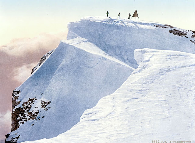
THE TITLIS IN VINTAGE POSTCARDS 1890

VINTAGE POSCARDS Titlis (3,238 m -10,623ft) Switzerland  In " Titlis Spitze, Unterwald - La Suisse en Couleur " postcard, 1890, The Library of Congress Photographs Division, Washington DC

VINTAGE POSCARDS
Titlis (3,238 m -10,623ft)
Switzerland

In " Titlis Spitze, Unterwald - La Suisse en Couleur " postcard, 1890,
The Library of Congress Photographs Division, Washington DC


The mountain
Titlis  (3,238 m - 10,623 ft) is a mountain of the Uri Alps, located on the border between the cantons of Obwalden and Bern. It is the highest summit of the range north of the Susten Pass, between the Bernese Oberland and Central Switzerland. It is mainly accessed from Engelberg (OW) on the north side and is famous as the site of the world's first rotating cable car.  The cable car system connects Engelberg (996 m (3,268 ft)) to the summit of Klein Titlis (3,028 m (9,934 ft)) through the three stages of Gerschnialp (1,262 m (4,140 ft)), Trübsee (1,796 m (5,892 ft)) and Stand (2,428 m (7,966 ft)), although somewhat recently, a newer, direct route was created that bypassed Gerachnialp, going directly to Trübsee.
The last part of cable car leads above the glacier. At Klein Titlis, it is possible to visit an illuminated glacier cave from an entrance within the cable-car station, which also includes shops and restaurants. The Titlis Cliff Walk, the highest elevation suspension bridge in Europe, opened in December 2012, giving views across the Alps. Many people use Titlis as a cheaper and easier option than Jungfraujoch.
In earlier times, Titlis was known under the names Wendenstock or Nollen. The Reissend Nollen and the Wendenstöcke are the nearest western neighbours to the mountain, slightly lower than Titlis, but with sharp rugged peaks. In a document of 1435 the mountain is called Tuttelsberg(Tutilos mountain), referencing to a man named Tutilos, who was probably a local farmer. The name, from Tutilos Berg, became Titlisberg and later Titlis.
The first ascent of Titlis was probably made in the year 1739. It was done by Ignaz Hess, J. E. Waser and two other men from Engelberg.  The first written evidence of an ascent is found in the Engelberger Dokumente. They mention a party of four men that reached the summit in 1744.
 On 21 January 1904 the first ski ascent of Titlis was made by Joseph Kuster and Willi Amrhein. In March 1967 the cable car to Klein Titlis (3,032 m) was inaugurated. In December 2012, the Titlis Cliff Walk opened to commemorate the 110th anniversary of the Engelberg-Gerschnialp cableway.


Vintage postcards
Postcards were colorized as soon as they appeared on the market at the end of 19th century ; the photos were then repainted by hand by women with very fine brushes, then a varnish was applied to fix these colors which were always very contrasting... and sometimes very far from reality!
Postcards became popular at the turn of the 20th century, especially for sending short messages to friends and relatives. They were collected right from the start, and are still sought after today by collectors of pop culture, photography, advertising, wartime memorabilia, local history, and many other categories. Postcards were an international craze, published all over the world. The Detroit Publishing Co. and Teich & Co. were two of the major publishers in the U.S, and sometimes individuals printed their own postcards as well. Yvon were the most famous in France. Many individual or anonymous publishers did exist around the world and especially in Africa and Asia (Japan, Thailand, Nepal, China, Java) between 1920 and 1955. These photographer were mostly local notables, soldiers, official guides belonging to the colonial armies (british french, belgium...) who sometimes had rather sophisticated equipment and readily produced colored photograms or explorers, navigators, climbers (Vittorio Sella and the Archiduke of Abruzzi future king of Italy remains the most famous of them).
There are many types of collectible vintage postcards.
Hold-to-light postcards were made with tissue paper surrounded by two pieces of regular paper, so light would shine through. Fold-out postcards, popular in the 1950s, had multiple postcards attached in a long strip. Real photograph postcards (RPPCs) are photographs with a postcard backing.
Novelty postcards were made using wood, aluminum, copper, and cork. Silk postcards–often embroidered over a printed image–were wrapped around cardboard and sent in see-through glassine paper envelopes; they were especially popular during World War I.
In the 1930s and 1940s, postcards were printed on brightly colored paper designed to look like linen.
Most vintage postcard collectors focus on themes, like Christmas, Halloween, portraits of movie stars, European royalty and U.S. presidents, wartime imagery, and photos of natural disasters or natural wonders. Not to mention cards featuring colorful pictures by famous artists like Alphonse Mucha, Harrison Fisher, Ellen Clapsaddle, and Frances Brundage.

__________________________________________
2022 - Wandering Vertexes...
by Francis Rousseau


Monday, February 21, 2022

THE TORRENTHORN IN VINTAGE POSTCARDS 1890


VINTAGE POSTCARDS The Torrenthorn (2,997 m - 9,832 ft) Switzerland (Valais)  In La Suisse en couleurs : Le village de Leukerbad et le Torrenthorn, Valais,  Carte postale 1890


VINTAGE POSTCARDS
The Torrenthorn (2,997 m - 9,832 ft)
Switzerland (Valais)


In  "La Suisse en couleurs : Le village de Leukerbad et le Torrenthorn, Valais", Carte postale 1890


The mountain
The Torrenthorn (2,997 m - 9,832 ft) is a summit of t he Bernese Alps, in Switzerland, located in the canton of Valais,  It is located southwest of the Majinghorn. Its western slope is part of the Loèche-les-Bains ski area, of which it overlooks the village, located to the west. The Bernese Alps are a mountain range of the Alps, located in western Switzerland.  Although the name suggests that they are located in the Berner Oberland region of the canton of Bern, portions of the Bernese Alps are in the adjacent cantons of Valais, Fribourg and Vaud, the latter being usually named Fribourg Alpsand Vaud Alps respectively. The highest mountain in the range, the Finsteraarhorn, is also the highest point in the canton of Bern. The Rhône valley separates them from the Chablais Alps in the west and from the Pennine Alps in the south; the upper Rhône valley separates them from the Lepontine Alps to the southeast; the Grimsel Pass and the Aare valley separates them from the Uri Alps in the east, and from the Emmental Alps in the north; their northwestern edge is not well defined, describing a line roughly from Lake Geneva to Lake Thun. The Bernese Alps are drained by the river Aare and its tributary the Saane in the north, the Rhône in the south, and the Reuss in the east.


Vintage postcards
Postcards were colorized as soon as they appeared on the market  at the end of 19th century ; the photos were then repainted by hand by women with very fine brushes, then a varnish was applied to fix these colors which were always very contrasting... and sometimes very far from reality!
Postcards became popular at the turn of the 20th century, especially for sending short messages to friends and relatives. They were collected right from the start, and are still sought after today by collectors of pop culture, photography, advertising, wartime memorabilia, local history, and many other categories. Postcards were an international craze, published all over the world. The Detroit Publishing Co. and Teich & Co. were two of the major publishers in the U.S, and sometimes individuals printed their own postcards as well. Yvon were the most famous in France. Many individual or anonymous publishers did exist around the world and especially in Africa and Asia (Japan, Thailand, Nepal, China, Java) between 1920 and 1955. These photographer were mostly local notables, soldiers, official guides belonging to the colonial armies (british french, belgium...) who sometimes had rather sophisticated equipment and readily produced colored photograms or explorers, navigators, climbers (Vittorio Sella and the Archiduke of Abruzzi future king of Italy remains the most famous of them).
There are many types of collectible vintage postcards.
Hold-to-light postcards were made with tissue paper surrounded by two pieces of regular paper, so light would shine through. Fold-out postcards, popular in the 1950s, had multiple postcards attached in a long strip. Real photograph postcards (RPPCs) are photographs with a postcard backing.
Novelty postcards were made using wood, aluminum, copper, and cork. Silk postcards–often embroidered over a printed image–were wrapped around cardboard and sent in see-through glassine paper envelopes; they were especially popular during World War I.
In the 1930s and 1940s, postcards were printed on brightly colored paper designed to look like linen.
Most vintage postcard collectors focus on themes, like Christmas, Halloween, portraits of movie stars, European royalty and U.S. presidents, wartime imagery, and photos of natural disasters or natural wonders. Not to mention cards featuring colorful pictures by famous artists like Alphonse Mucha, Harrison Fisher, Ellen Clapsaddle, and Frances Brundage.

__________________________________________ 


2022 - Wandering Vertexes...
by Francis Rousseau


Wednesday, January 23, 2019

MOUNT SIR DONALD IN VINTAGE POSTCARD 1902


VINTAGE POSTCARDS 
Mount Sir Donald  (3, 284 m - 10,774  ft)
Canada

 In Mount Sir Donald,  © Detroit Photographic Co..., 1902

The mountain 
Mount Sir Donald  (3, 284 m - 10,774  ft) is a peak in the Selkirk Mountains range near the Rogers Pass area of British Columbia, Canada. It was originally named Syndicate Peak in honor of the group who arranged the finances for the completion of the Canadian Pacific Railway, but was later renamed after Donald Smith, 1st Baron Strathcona and Mount Royal, head of the syndicate.
The  good rock quality of Mount Sir Donald and  its classic Matterhorn shape make it popular for alpine rock climbers, and the Northwest Arete route is included in the popular book 50 Classic Climbs of North America. There are no truly easy routes to its summit although some of the routes are not technically difficult. Even before its inclusion as one of the 50 classic climbs of North America the peak was a very popular objective indeed, especially the Northwest Ridge. It is worth noting that the peak seems to create its own weather at times as it towers above the surrounding peaks, and the lichen on the rock is very slippery when wet. The recorded routes on all sides range in rating from class 4 to 5.8+.
The first ascent was made in 1890 by two Swiss alpinist, Emil Huber and Carl Sulzer and porter Harry Cooper. As of the 1910s, an average of three or four ascents per year were being made.

Vintage postcards
Postcards became popular at the turn of the 20th century, especially for sending short messages to friends and relatives. They were collected right from the start, and are still sought after today by collectors of pop culture, photography, advertising, wartime memorabilia, local history, and many other categories. Postcards were an international craze, published all over the world. The Detroit Publishing Co. and Teich & Co. were two of the major publishers in the U.S, and sometimes individuals printed their own postcards as well. Yvon were the most famous in France. Many individual or anonymous publishers did exist around the world and especially in Africa and  Asia (Japan, Thailand, Nepal, China, Java) between 1920 and 1955. These photographer were mostly local notables, soldiers, official guides belonging to the colonial armies (british french, belgium...) who sometimes had rather sophisticated equipment and readily produced colored photograms or explorers, navigators, climbers (Vittorio Sella and the Archiduke of Abruzzi future king of Italy remains the most famous of them).
There are many types of collectible vintage postcards.
Hold-to-light postcards were made with tissue paper surrounded by two pieces of regular paper, so light would shine through. Fold-out postcards, popular in the 1950s, had multiple postcards attached in a long strip. Real photograph postcards (RPPCs) are photographs with a postcard backing.
Novelty postcards were made using wood, aluminum, copper, and cork. Silk postcards–often embroidered over a printed image–were wrapped around cardboard and sent in see-through glassine paper envelopes; they were especially popular during World War I.
In the 1930s and 1940s, postcards were printed on brightly colored paper designed to look like linen.


Most vintage postcard collectors focus on themes, like Christmas, Halloween, portraits of movie stars, European royalty and U.S. presidents, wartime imagery, and photos of natural disasters or natural wonders. Not to mention cards featuring colorful pictures by famous artists like Alphonse Mucha, Harrison Fisher, Ellen Clapsaddle, and Frances Brundage.
_______________________________

2019 - Wandering Vertexes...
by Francis Rousseau 

Thursday, October 18, 2018

MUHABURA VOLCANO IN VINTAGE POSTCARD 1930


VINTAGE POSTCARDS 1930 
Mount Muhabura  (4,127 m - 13,540 ft) 
Rwanda - Uganda border 

`The mountain 
Mount Muhabura  ( 4,127 m - 13,540 ft)  also known as Mount Muhavura, is an extinct volcano in the Virunga Mountains on the border between Rwanda and Uganda. Muhabura is the third highest of the eight major mountains of the mountain range, which is a part of the Albertine Rift, the western branch of the East African Rift. Muhabura is partly in the Volcanoes National Park, Rwanda and partly in the Mgahinga Gorilla National Park, Uganda. The name Muhabura means "The Guide" in the local language, Kinyarwanda. It can be seen from many parts of Uganda and Rwanda because of its slope.


2018 - Wandering Vertexes...
by Francis Rousseau 

Sunday, May 27, 2018

MOUNT KENYA IN VINTAGE POSTCARDS 1940


VINTAGE POSTCARDS 1940 
Mount Kenya (5,199 m -17,057 ft) 
Kenya 

 In  Mount Kenya, The Commonwealth institute London, Anonymous painter, 1940, Posstcard 

The mountain 
Mount Kenya  (5,199 m -17,057 ft)  is the highest mountain in Kenya and the second-highest in Africa, after Kilimanjaro.   The origin of the name Kenya is not clear, but perhaps linked to the Kikuyu, Embu and Kamba words Kirinyaga, Kirenyaa and Kiinyaa which mean "God's resting place" in all three languages.  Mount Kenya is located in central Kenya, about 16.5 kilometres (10.3 mi) south of the equator, around 150 kilometres (93 mi) north-northeast of the capital Nairobi. Mount Kenya is the source of the name of the Republic of Kenya.
Mount Kenya is a stratovolcano created approximately 3 million years after the opening of the East African rift.   Before glaciation, it was 7,000 m (23,000 ft) high. It was covered by an ice cap for thousands of years. This has resulted in very eroded slopes and numerous valleys radiating from the centre.  There are currently 11 small glaciers and 8 peaks of which the highest are : Batian (5,199 m -  (17,057 ft), Nelion (5,188 m - 17,021 ft)) and Point Lenana (4,985 m - 16,355 ft).   The forested slopes are an important source of water for much of Kenya.

There are several vegetation bands from the base to the summit. The lower slopes are covered by different types of forest. Many alpine species are endemic to Mount Kenya, such as the giant lobelias and senecios and a local subspecies of rock hyrax. An area of 715 km2 (276 sq mi) around the centre of the mountain was designated a National Park and listed as a UNESCO World Heritage Site in 1997.  The park receives over 16,000 visitors per year.
The main ethnic groups living around Mount Kenya are Kikuyu, Ameru, Embu and Maasai.
The first three are closely related. They all see the mountain as an important aspect of their cultures.  The most famous Maasai  are semi-nomadic people, who use the land to the north of the mountain to graze their cattle. They believe that their ancestors came down from the mountain at the beginning of time.  The Maasai name for Mount Kenya is Ol Donyo Keri, which means 'mountain of stripes', referring to the dark shades as observed from the surrounding plains.  At least one Maasai prayer refers to Mount Kenya: " God bless our children, let them be like the olive tree of Morintat, let them grow and expand, let them be like Ngong Hills like Mt. Kenya, like Mt. Kilimanjaro and multiply in number. "
All these cultures arrived in the Mount Kenya area in the last several hundred years.

Friday, April 13, 2018

EL MISTI IN VINTAGE POSTCARD 1920


VINTAGE POSTCARDS 1920 
El Misti or Guagua Putina (5,822m -19,101ft)
Peru 

The mountain 
El Misti (5,822m -19,101ft) also known as Guagua Putina, is a stratovolcano located in southern Peru near the city of Arequipa. With its seasonally snow-capped, symmetrical cone, Misti lies between mount Chachani (6,075m - 19,931ft) and Pichu Pichu volcano (5,669 m -18,599 ft).
El Misti  is located at 3,415m above the sea level on the Altiplano and the elevation of the cone is approximatively 2,400m  above the Altiplano base. El Misti has three concentric craters. In the inner crater fumarole activity can often be seen. The symmetric conical shape of El Misti is typical of a stratovolcano, a type of volcano characterized by alternating layers of lava and debris from explosive eruptions, such as ash and pyroclastic flows. Stratovolcanoes are usually located on the continental crust above a subducting tectonic plate. The magma feeding the stratovolcanoes of the Andes Mountains, including El Misti, is associated with ongoing subduction of the Nazca Plate beneath the South American Plate. Its most recent relatively minor eruption was in 1985, 198 years after its previous documented eruption. Near the inner crater six Inca mummies and rare Inca artifacts were found in 1998 during a month-long excavation directed by archaeologists Johan Reinhard and Jose Antonio Chavez. These findings are currently stored at the Museo de Santuarios Andinos in Arequipa.
The city center of Arequipa, Peru, lies only 17 kilometers (11 miles) away from the summit of El Misti; the gray urban area is bordered by green agricultural fields. With almost 1 million residents in 2009, it is the second largest city in Peru in terms of population. Much of the building stone for Arequipa, known locally as sillar, is quarried from nearby pyroclastic flow deposits that are white. Arequipa is known as the “White City” because of the prevalence of this building material. The Chili River extends northeastwards from the city center and flows through a canyon between El Misti volcano and Nevado Chachani to the north. Nevado Chachani is a volcanic complex that may have erupted during the Holocene Epoch (from about 10,000 years ago to the present), but no historical eruptions have been observed there.

Vintage postcards
Postcards became popular at the turn of the 20th century, especially for sending short messages to friends and relatives. They were collected right from the start, and are still sought after today by collectors of pop culture, photography, advertising, wartime memorabilia, local history, and many other categories. Postcards were an international craze, published all over the world. The Detroit Publishing Co. and Teich & Co. were two of the major publishers in the U.S, and sometimes individuals printed their own postcards as well. Yvon were the most famous in France. Many individual or anonymous publishers did exist around the world and especially in Africa and  Asia (Japan, Thailand, Nepal, China, Java) between 1920 and 1955. These photographer were mostly local notables, soldiers, official guides belonging to the colonial armies (british french, belgium...) who sometimes had rather sophisticated equipment and readily produced colored photograms or explorers, navigators, climbers (Vittorio Sella and the Archiduke of Abruzzi future king of Italy remains the most famous of them).
There are many types of collectible vintage postcards.
Hold-to-light postcards were made with tissue paper surrounded by two pieces of regular paper, so light would shine through. Fold-out postcards, popular in the 1950s, had multiple postcards attached in a long strip. Real photograph postcards (RPPCs) are photographs with a postcard backing.
Novelty postcards were made using wood, aluminum, copper, and cork. Silk postcards–often embroidered over a printed image–were wrapped around cardboard and sent in see-through glassine paper envelopes; they were especially popular during World War I.
In the 1930s and 1940s, postcards were printed on brightly colored paper designed to look like linen.
Most vintage postcard collectors focus on themes, like Christmas, Halloween, portraits of movie stars, European royalty and U.S. presidents, wartime imagery, and photos of natural disasters or natural wonders. Not to mention cards featuring colorful pictures by famous artists like Alphonse Mucha, Harrison Fisher, Ellen Clapsaddle, and Frances Brundage.

Tuesday, March 6, 2018

MOUNT PILATUS / TOMLISHORN IN VINTAGE POSTCARD 1890


VINTAGE POSTCARD 1890
 Mount Pilatus or Tomlishorn (2,128 m - 6,982 ft)
Switzerland

 In La gare de Lucerne et le Mont Pilatus au clair de lune, La Suisse en Couleur,  1890, 
 Photochrom color print, The Library of Congress, Wahington D.C.

The mountain 
Mount Pilatus overlooking Lucerne in central Switzerland. It is composed of several summits of which the highest is named Tomlishorn.(2,128 m - 6,982 ft).  Another summit named Esel (2,119 m) lies just over the railway station. Jurisdiction over the massif is divided between the cantons of ObwaldenNidwalden, and Lucerne. The main peaks are right on the border between Obwalden and Nidwalden.
A few different local legends about the origin of the name exist. One claims that Mount Pilatus was named so because Pontius Pilate was buried there; a similar legend is told of Monte Vettore in Italy. Another is that the mountain looks like the belly of a large man, Pilate, lying on his back and was thus named for him. The name may also be derived from "pileatus," meaning "cloud-topped."
A medieval legend had dragons with healing powers living on the mountain. A chronicle from 1619 reads: 'as I was contemplating the serene sky by night, I saw a very bright dragon with flapping wings go from a cave in a great rock in the mount called Pilatus toward another cave, known as Flue, on the opposite side of the lake'. 
Nowadays, dragon has been replaced by fortified radar (part of the Swiss FLORAKO system) and weather stations on the Oberhaupt summit, not open to the public view and used all year round.
The top can be reached with the Pilatus railway, the world's steepest cogwheel railway, from Alpnachstad, operating from May to November (depending on snow conditions), and the whole year with the aerial panorama gondolas and aerial cableways from Kriens. Both summits of Tomlishorn and Esel can be reached with a trail. Mount Pilatus has the longest summer toboggan track in Switzerland (0.88 miles or 1,350 m) and the biggest suspension rope park in Central Switzerland.
During the summer, the "Golden Round Trip" — a popular route for tourists — involves taking a boat from Lucerne across Lake Lucerne to Alpnachstad, going up on the cogwheel railway, coming down on the aerial cableways and panorama gondolas, and taking a bus back to Lucerne.
Numbered amongst those who have reached its summit are Conrad GessnerTheodore RooseveltArthur Schopenhauer (1804), Queen Victoria and Julia Ward Howe (1867).

The photos 
The Library of Congress' Photochrom prints collection contains almost 6,000 views of Europe and the Middle East and 500 views of North America. Published primarily from the 1890s to 1910s, these prints were created by the Photoglob Company in Zürich, Switzerland, and the Detroit Publishing Company in Michigan. The richly colored images look like photographs but are actually ink-based photolithographs, usually 6.5 x 9 inches.
Like postcards, the photochroms feature subjects that appeal to travelers, including landscapes, architecture, street scenes, and daily life and culture. The prints were sold as souvenirs and often collected in albums or framed for display.
The Library of Congress Prints and Photographs Division assembled this collection from two sources that provided prints in mint condition. In 1985, the prints of Europe and the Middle East were purchased from the Galerie Muriset in Switzerland. In 2004, Howard L. Gottlieb generously donated the North American views. Additional photochroms can be found in the collections listed in the Related Resources section.

Monday, December 25, 2017

MOUNT SHASTA IN VINTAGE POSTCARD 1966


VINTAGE POSTCARD 1966
Mount Shasta (4,322 m - 14,179 ft)
United Sates of America  (California)

The mountain 
Mount Shasta (4,322 m- 14,179 ft) named after a tribe of native american the Shasta, is also called "Uytaahkoo" (in Karuk) or "White Mountain". It  is a potentially active volcano (last known eruption in 1786) at the southern end of the Cascade Range in Siskiyou CountyCalifornia. Mount Shasta  is the most voluminous stratovolcano in the Cascade Volcanic ArcThe mountain and its surrounding area are managed by the U.S. Forest Service as part of the Shasta-Trinity National Forest. Mount Shasta was declared a National Natural Landmark in December 1976.
In his Picturesque California in 1888, John Muir  described Mount Shasta and its area  "The Shasta region is still a fresh unspoiled wilderness, accessible and available for travelers of every kind and degree. Would it not be a fine thing to set it apart like the Yellowstone and Yosemite as a National Park for the welfare and benefit of all mankind, preserving its fountains and forests and all its glad life in primeval beauty?"
At the time of Euro-American contact in the 1820s, the Native American tribes who lived within view of Mount Shasta included: the ShastaOkwanuchuModocAchomawiAtsugewiKarukKlamathWintu, and Yana tribes. 
The historic eruption of Mount Shasta in 1786 may have been observed by the french explorer Lapérouse. Although perhaps first seen by Spanish explorers, the first reliably reported land sighting of Mount Shasta by a European or American was by Peter Skene Ogden (a leader of a Hudson's Bay Company trapping brigade) in 1826. In 1827, the name "Sasty" or "Sastise" was given to nearby Mount McLoughlin by Ogden. The name was transferred to present-day Mount Shasta in 1841, partly as a result of work by the United States Exploring Expedition.
The lore of some of the Klamath Tribes in the area held that Mount Shasta is inhabited by the Spirit of the Above-World, , who descended from heaven to the mountain's summit at the request of a Klamath chief. Skell fought with Spirit of the Below-World, Llao, who resided at Mount Mazama by throwing hot rocks and lava, probably representing the volcanic eruptions at both mountains.
 A group of Native Americans from the McCloud River area practice rituals on the mountain.
Mount Shasta has also been a focus for non-Native American legends, centered on a hidden city of advanced beings from the lost continent of Lemuria. The legend grew from an offhand mention of Lemuria in the 1880s, to a description of a hidden Lemurian village in 1925. In 1931, Wisar Spenle Cerve wrote Lemuria: the lost continent of the Pacific, published by the Rosicrucians, about the hidden Lemurians of Mount Shasta that cemented the legend in many readers' minds.
In August 1987, believers in the spiritual significance of the Harmonic Convergence described Mount Shasta as one of a small number of global "power centers". Mount Shasta remains a focus of "New Age" attention.
Mount Shasta is connected to nearby Shastina, and they dominate the northern California landscape. 
The mountain consists of four overlapping volcanic cones that have built a complex shape, including the main summit and the prominent satellite cone of 12,330 ft (3,760 m) Shastina, which has a visibly conical form. If Shastina were a separate mountain, it would rank as the fourth-highest peak of the Cascade Range (after Mount Rainier, Rainier's Liberty Cap, and Mount Shasta itself).
Mount Shasta's surface is relatively free of deep glacial erosion except, paradoxically, for its south side where Sargents Ridge runs parallel to the U-shaped Avalanche Gulch. This is the largest glacial valley on the volcano, although it does not presently have a glacier in it. There are seven named glaciers on Mount Shasta, with the four largest (WhitneyBolamHotlum, and Wintun) radiating down from high on the main summit cone to below 10,000 ft (3,000 m) primarily on the north and east sides. The Whitney Glacier is the longest, and the Hotlum is the most voluminous glacier in the state of California. Three of the smaller named glaciers occupy cirques near and above 11,000 ft (3,400 m) on the south and southeast sides, including the WatkinsKonwakiton, and Mud Creek glaciers.

Vintage postcards
Postcards became popular at the turn of the 20th century, especially for sending short messages to friends and relatives. They were collected right from the start, and are still sought after today by collectors of pop culture, photography, advertising, wartime memorabilia, local history, and many other categories. Postcards were an international craze, published all over the world. The Detroit Publishing Co. and Teich & Co. were two of the major publishers in the U.S, and sometimes individuals printed their own postcards as well. Yvon were the most famous in France. Many individual or anonymous publishers did exist around the world and especially in Africa and  Asia (Japan, Thailand, Nepal, China, Java) between 1920 and 1955. These photographer were mostly local notables, soldiers, official guides belonging to the colonial armies (british french, belgium...) who sometimes had rather sophisticated equipment and readily produced colored photograms or explorers, navigators, climbers (Vittorio Sella and the Archiduke of Abruzzi future king of Italy remains the most famous of them).
There are many types of collectible vintage postcards.
Hold-to-light postcards were made with tissue paper surrounded by two pieces of regular paper, so light would shine through. Fold-out postcards, popular in the 1950s, had multiple postcards attached in a long strip. Real photograph postcards (RPPCs) are photographs with a postcard backing.
Novelty postcards were made using wood, aluminum, copper, and cork. Silk postcards–often embroidered over a printed image–were wrapped around cardboard and sent in see-through glassine paper envelopes; they were especially popular during World War I.
In the 1930s and 1940s, postcards were printed on brightly colored paper designed to look like linen.

Most vintage postcard collectors focus on themes, like Christmas, Halloween, portraits of movie stars, European royalty and U.S. presidents, wartime imagery, and photos of natural disasters or natural wonders. Not to mention cards featuring colorful pictures by famous artists like Alphonse Mucha, Harrison Fisher, Ellen Clapsaddle, and Frances Brundage.

Sunday, December 17, 2017

MOUNT SAN ANTONIO / MOUNT BALDY IN VINTAGE POSTCARD 1925


VINTAGE POSTCARD 1925
Mount Sain Antonio- Mount Baldy (3, 068 m - 10, 064 ft) 
United States of America (California) 

The mountain
Mount San Antonio (3, 068 m - 10, 064 ft)  colloquially referred to as Mount Baldy or "Old Badly " is the highest peak of the San Gabriel Mountains, and the highest point in Los Angeles County, California. The peak is within the San Gabriel Mountains National Monument and Angeles National Forest. Mount San Antonio's sometimes snow-capped peaks are visible on clear days and dominate the view of the Los Angeles Basin skyline.
The mountain was named by a local rancher after Saint Anthony of Padua. When American settlers arrived and surveyed the land, "Baldy", a reference to the bare fell-field of Baldy Bowl that dominates the south face visible from Los Angeles, became the predominant name, and it has stuck. Nonetheless, "Mount San Antonio" is the official name according to the GNIS, and is still used by a number of institutions .
The peak is pyramid shaped, with a steep south face (Baldy Bowl) and a shallower north face. The summit is accessible via a number of connecting ridges along hiking trails from the north, east, south and southwest. The summit has two peaks: the main peak, elevation 10,064 feet (3,068 m), and a sub-peak, West Baldy, at 9,988 feet (3,044 m). The main peak marks the boundary between San Bernardino County and Los Angeles County. The mountain is in the Angeles National Forest.
Mount San Antonio lies in the front range of the San Gabriel Mountains, one of the Transverse Ranges of Southern California, formed around the San Andreas Fault system. The Transverse Ranges were formed because of a dog-leg bend in the San Andreas, which is a transform fault. The bend makes it difficult for the two plates to move smoothly past one another, and mountains were raised as a result.

Vintage postcards
Postcards became popular at the turn of the 20th century, especially for sending short messages to friends and relatives. They were collected right from the start, and are still sought after today by collectors of pop culture, photography, advertising, wartime memorabilia, local history, and many other categories. Postcards were an international craze, published all over the world. The Detroit Publishing Co. and Teich & Co. were two of the major publishers in the U.S, and sometimes individuals printed their own postcards as well. Yvon were the most famous in France. Many individual or anonymous publishers did exist around the world and especially in Africa and  Asia (Japan, Thailand, Nepal, China, Java) between 1920 and 1955. These photographer were mostly local notables, soldiers, official guides belonging to the colonial armies (british french, belgium...) who sometimes had rather sophisticated equipment and readily produced colored photograms or explorers, navigators, climbers (Vittorio Sella and the Archiduke of Abruzzi future king of Italy remains the most famous of them).
There are many types of collectible vintage postcards.
Hold-to-light postcards were made with tissue paper surrounded by two pieces of regular paper, so light would shine through. Fold-out postcards, popular in the 1950s, had multiple postcards attached in a long strip. Real photograph postcards (RPPCs) are photographs with a postcard backing.
Novelty postcards were made using wood, aluminum, copper, and cork. Silk postcards–often embroidered over a printed image–were wrapped around cardboard and sent in see-through glassine paper envelopes; they were especially popular during World War I.
In the 1930s and 1940s, postcards were printed on brightly colored paper designed to look like linen.
Most vintage postcard collectors focus on themes, like Christmas, Halloween, portraits of movie stars, European royalty and U.S. presidents, wartime imagery, and photos of natural disasters or natural wonders. Not to mention cards featuring colorful pictures by famous artists like Alphonse Mucha, Harrison Fisher, Ellen Clapsaddle, and Frances Brundage.


Sunday, August 6, 2017

NEVADO ILLIMANI IN VINTAGE POSTCARD 1949


VINTAGE POSTCARD 1949
Nevado Illimani or El Illimani (6,438 m - 21,122ft) 
Bolivia

The mountain 
Nevado Illimani is the highest mountain in the Cordillera Real (part of the Cordillera Oriental, a subrange of the Andes) of western Bolivia. It lies near the cities of El Alto and La Paz at the eastern edge of the Altiplano. It is the second highest peak in Bolivia, after Nevado Sajama, and the eighteenth highest peak in South America.  The snow line lies at about 4,570 metres (15,000 ft) above sea level, and glaciers are found on the northern face at 4,983 m (16,350 ft). The mountain has four main peaks; the highest is the south summit, Nevado Illimani, which is a popular ascent for mountain climbers. Geologically, Illimani is composed primarily of granodiorite, intruded during the Cenozoic era into the sedimentary rock, which forms the bulk of the Cordillera Real.
The mountain has been the subject of many local songs, most importantly "Illimani", with the following refrain: "Illimani, Illimani, centinela tu eres de La Paz! Illimani, Illimani, patrimonio eres de Bolivia!" ("Illimani, Illimani, you are the sentinel of La Paz! Illimani, Illimani, you are Bolivia's heritage!")
Illimani was first attempted in 1877 by the French explorators Charles Wiener, J. de Grumkow, and J. C. Ocampo. They failed to reach the main summit, but did reach a southeastern subsummit, on 19 May 1877, Wiener named it the "Pic de Paris", and left a French flag on top of it.  In 1898, British climber William Martin Conway and two Swiss guides, A. Maquignaz and L. Pellissier, made the first recorded ascent of the peak, again from the southeast. (They found a piece of Aymara rope at over 6,000 m (20,000 ft), so an earlier ascent cannot be completely discounted.)
The current standard route on the mountain climbs the west ridge of the main summit. It was first climbed in 1940, by the Germans R. Boetcher, F. Fritz, and W. Kühn, and is graded French PD+/AD-. This route usually requires four days, the summit being reached in the morning of the third day.
In July 2010 German climber Florian Hill and long-time Bolivian resident Robert Rauch climbed a new route on the 'South Face', completing most of the 1700m of ascent in 21 hours. Deliver Me (WI 6 and M6+) appears to climb the gable-end of the South West Ridge, a very steep wall threatened by large broken seracs.
Illimani was the site where Eastern Air Lines Flight 980 crashed on January 1, 1985.

Vintage postcards 
- More informations about Vintage Postcards 

Sunday, July 16, 2017

MOUNT CAMEROON IN VINTAGE POSTCARD 1889


VINTAGE POSTCARD 1889
Mount Cameroon (4, 040 m - 13,250 ft) 
Cameroon 

In Kamerun Victoria am Kamerunberg, 1889, hand painted german postcard, 

The mountain 
Mount Cameroon (4, 040 m - 13,250 ft) is an active volcano in Cameroon near the Gulf of Guinea (Africa). Mount Cameroon is also known as Cameroon Mountain or Fako (the name of the higher of its two peaks) or by its native name Mongo ma Ndemi ("Mountain of Greatness"). It is the highest point in sub-Saharan western and central Africa,  the fourth most prominent peak in Africa and the 31st most prominent in the world. It rises from the coast through tropical rainforest to a bare summit which is cold, windy, and occasionally dusted with snow. 
The mountain is part of the area of volcanic activity known as the Cameroon Volcanic Line, which also includes Lake Nyos. More than 100 small cinder cones, often fissure-controlled parallel to the long axis of the massive 1,400-cubic-kilometre (336 cu mi) volcano, occur on the flanks and surrounding lowlands. A large satellitic peak, Etinde (also known as Little Mount Cameroon), is located on the southern flank near the coast. 
Mount Cameroon has the most frequent eruptions of any West African volcano. 
The first written account of volcanic activity could be the one from the Carthaginian Hanno the Navigator, who might have observed the mountain in the 5th century BC. Moderate explosive and effusive eruptions have occurred throughout history from both summit and flank vents. A 1922 eruption on the southwestern flank produced a lava flow that reached the Atlantic coast, and a lava flow from a 1999 south-flank eruption stopped only 200 m (660 ft) from the sea, cutting the coastal highway.  The most recent eruption occurred on February 3, 2012.
English explorer Mary Kingsley, was one of the first Europeans to scale the mountain in 1897.
The peak is frequently ascended by hikers. The annual Mount Cameroon Race of Hope scales the peak in around 4½ hours. Sarah Etonge, who has won the race seven times and is also a tour operator, has become known as queen of the mountain.

Saturday, July 15, 2017

MAYON VOLCANO IN 3 VINTAGE POSTCARDS 1890, 1899, 1928


VINTAGE POSTCARDS (1899-1928)
Mayon volcano (2,463m- 8,061ft)
Philippines (Luzon)

1. In Mayon in 1899, Private collection  
2.  In Evocation of The Mayon 1814 eruption,  hand painted postcard, circa 1880-1900, P.C.
3. In Mayon eruption, July 21, 1928, Philippines Army Archives

The mountain 
Mayon volcano (2,463 m- 8,061 ft) also called Bulkan Mayon or Bulkang Mayon or Mount Mayon or Mayon is an active stratovolcano in the province of Albay in Bicol Region, on the island of Luzon in the Philippines. Renowned as the "perfect cone" because of its symmetric conical shape, the volcano and its surrounding landscape was declared a national park on July 20, 1938, the first in the nation. It was reclassified a Natural Park and renamed Mayon Volcano Natural Park in the year 2000. Local folklore refers to the volcano being named after the legendary princess-heroine Daragang Magayon (Beautiful Lady).
Mayon volcano is the most active volcano in the Philippines, erupting over 49 times in the past 400 years. 
-  In February 1616 , the first record of a major eruption was witnessed  by Dutch explorer Joris van Spilbergen who recorded it on his log in his circumnavigation trip around the world.
- July 20, 1766.: the first eruption for which an extended account exists was the six-day event.
- February 1, 1814 (VEI=4).  The most destructive eruption of Mayon; Lava flowed but less than the 1766 eruption. The volcano belched dark ash and eventually bombarded the town of Cagsawa with tephra that buried it. (see photo 2 above)
- From July 6, 1881 until approximately August 1882, Mayon underwent a strong (VEI=3) eruption. Samuel Kneeland, a naturalist, professor and geologist, personally observed the volcanic activity on Christmas Day, 1881, about five months after the start of the activity:
« At the date of my visit, the volcano had poured out, for five months continuously, a stream of lava on the Legaspi side from the very summit. The viscid mass bubbled quietly but grandly, and overran the border of the crater, descending several hundred feet in a glowing wave, like red-hot iron. »
- Mayon's longest uninterrupted eruption occurred on June 23, 1897 (VEI=4), which lasted for seven days of raining fire. Lava once again flowed down to civilization. Eleven kilometers (7 miles) eastward, the village of Bacacay was buried 15 m (49 ft) beneath the lava. In Libon 100 people were killed by steam and falling debris or hot rocks.
- No casualties were recorded from the 1984 eruption after more than 73,000 people were evacuated from the danger zones as recommended by PHIVOLCS scientists.[12] But in 1993, pyroclastic flows killed 75 people, mainly farmers, during the eruption.
- Mayon's 48th modern-era eruption was on July 13, 2006, followed by quiet effusion of lava that started on July 14, 2006. Nearly 40,000 people were evacuated from the 8-kilometre (5.0 mi) danger zone on the southeast flank of the volcano.
- On August 10, 2008, a small summit explosion ejected ash 200 metres (660 ft) above the summit, which drifted east-northeast. In the weeks prior to the eruption, a visible glow increased within the crater and increased seismicity.
- 2009–2010 eruption several explosion and eruption from July 10, 2009 to January 13, 2010.  
- On May 7, 2013, at 8 a.m. (PST), the volcano produced a surprise phreatic eruption lasting 73 seconds. Ash, steam and rock were produced during this eruption. Ash clouds reached 500 meters above the volcano's summit and drifted west southwest. The event killed five climbers, of whom three were German, one was a Spaniard living in Germany, and one was a Filipino tour guide. Seven others were reported injured. The bodies of the hikers were soon located by the authorities.
- On August 12, 2014, a new 30m-50m high lava dome appeared in the summit crater. This event was preceded by inflations of the volcano (measured by precise leveling, tilt data, and GPS), and increases in sulphur dioxide gas emissions.

Vintage postcards
Postcards became popular at the turn of the 20th century, especially for sending short messages to friends and relatives. They were collected right from the start, and are still sought after today by collectors of pop culture, photography, advertising, wartime memorabilia, local history, and many other categories. Postcards were an international craze, published all over the world. The Detroit Publishing Co. and Teich & Co. were two of the major publishers in the U.S, and sometimes individuals printed their own postcards as well. Yvon were the most famous in France. Many individual or anonymous publishers did exist around the world and especially in Africa and  Asia (Japan, Thailand, Nepal, China, Java) between 1920 and 1955. These photographer were mostly local notables, soldiers, official guides belonging to the colonial armies (british french, belgium...) who sometimes had rather sophisticated equipment and readily produced colored photograms or explorers, navigators, climbers (Vittorio Sella and the Archiduke of Abruzzi future king of Italy remains the most famous of them).
There are many types of collectible vintage postcards.
Hold-to-light postcards were made with tissue paper surrounded by two pieces of regular paper, so light would shine through. Fold-out postcards, popular in the 1950s, had multiple postcards attached in a long strip. Real photograph postcards (RPPCs) are photographs with a postcard backing.
Novelty postcards were made using wood, aluminum, copper, and cork. Silk postcards–often embroidered over a printed image–were wrapped around cardboard and sent in see-through glassine paper envelopes; they were especially popular during World War I.
In the 1930s and 1940s, postcards were printed on brightly colored paper designed to look like linen.
Most vintage postcard collectors focus on themes, like Christmas, Halloween, portraits of movie stars, European royalty and U.S. presidents, wartime imagery, and photos of natural disasters or natural wonders. Not to mention cards featuring colorful pictures by famous artists like Alphonse Mucha, Harrison Fisher, Ellen Clapsaddle, and Frances Brundage.
- More Vintage postcards 

Thursday, July 13, 2017

MOUNT RUSHMORE IN VINTAGE POSTCARDS 1945


VINTAGE POSTCARDS  1945
Mount Rushmore (1,745 m - 5,725 feet)
United States of America (South Dakota)

1. In Greetings from Mount Rushmore, colored postcard, 1945  
2.  In Mount Rushmore (Six Grandfathers) before it was carved, 1905 


The Mountain 
Mount Rushmore (1,745 m - 5,725 feet)  originally know by the Sioux Dakota as The Six Grandftahers is a batholith in the Black Hills in Keystone, South Dakota, United States. The mountain was renamed after Charles E. Rushmore, a prominent New York lawyer, during an expedition in 1885. The memorial is carved on the northwest margin of the Black Elk Peak granite batholith, so the geologic formations of the heart of the Black Hills region are also evident at Mount Rushmore. The batholith magma intruded into the pre-existing mica schist rocks during the Proterozoic, 1.6 billion years ago. Coarse grained pegmatite dikes are associated with the granite intrusion of Black Elk Peak and are visibly lighter in color, thus explaining the light-colored streaks on the foreheads of the presidents.
Sculptor Gutzon Borglum created the sculpture's design and oversaw the project's execution from 1927-1941 with the help of his son, Lincoln Borglum. Mount Rushmore features 60-foot (18 m) sculptures of the heads of four United States presidents: George Washington (1732–1799), Thomas Jefferson (1743–1826), Theodore Roosevelt (1858–1919), and Abraham Lincoln (1809–1865).
The United States seized the area from the Lakota tribe after the Great Sioux War of 1876. The Treaty of Fort Laramie from 1868 had previously granted the Black Hills to the Lakota in perpetuity. Members of the American Indian Movement led an occupation of the monument in 1971, naming it "Mount Crazy Horse". Among the participants were young activists, grandparents, children and Lakota holy man John Fire Lame Deer, who planted a prayer staff atop the mountain. Lame Deer said the staff formed a symbolic shroud over the presidents' faces "which shall remain dirty until the treaties concerning the Black Hills are fulfilled."
In 2004, the first Native American superintendent of the park, Gerard Baker, was appointed. Baker has stated that he will open up more "avenues of interpretation", and that the four presidents are "only one avenue and only one focus."
The Crazy Horse Memorial is being constructed elsewhere in the Black Hills to commemorate the famous Native American leader as a response to Mount Rushmore. It is said to be larger than Mount Rushmore and has the support of Lakota chiefs; the Crazy Horse Memorial Foundation has rejected offers of federal funds. However, this memorial is likewise the subject of controversy, even within the Native American community.

Monday, June 12, 2017

THE GRAND CANYON OF COLORADO IN VINTAGE POSTCARD 1950


VINTAGE POSTCARD 1950
The Grand Canyon of Colorado  (1,857m -  6,093ft)
United States of America (Arizona)

 In Grand-Canyon, View from the South Rim, postcard 1950, The Detroit Publishing Co.  

The canyon 
The Grand Canyon (1,857m -  6,093ft deep) also called in Hopi Ongtupqa, in Yavapai Wi:kaʼi:la, in Navajo Tsékooh Hatsoh and in Spanish  Gran Caсуn is a steep-sided canyon carved by the Colorado River in the U.S. state of Arizona in North America. It is contained within and managed by Grand Canyon National Park, the Kaibab National Forest, Grand Canyon-Parashant National Monument, the Hualapai Tribal Nation, the Havasupai people and the Navajo Nation. President Theodore Roosevelt was a major proponent of preservation of the Grand Canyon area, and visited it on numerous occasions to hunt and enjoy the scenery.
The Grand Canyon is 277 miles (446 km) long, up to 18 miles (29 km) wide. Nearly two billion years of Earth's geological history have been exposed as the Colorado River and its tributaries cut their channels through layer after layer of rock while the Colorado Plateau was uplifted. While some aspects about the history of incision of the canyon are debated by geologists, several recent studies support the hypothesis that the Colorado River established its course through the area about 5 to 6 million years ago. Since that time, the Colorado River has driven the down-cutting of the tributaries and retreat of the cliffs, simultaneously deepening and widening the canyon.
For thousands of years, the area has been continuously inhabited by Native Americans, who built settlements within the canyon and its many caves. The Pueblo people considered the Grand Canyon a holy site, and made pilgrimages to it. 
The first European known to have viewed the Grand Canyon was Garcia Lopez de Cбrdenas from Spain, who arrived in 1540. 
The Grand Canyon area has some of the cleanest air in the United States. However at times the air quality can be considerably affected by events such as forest fires and dust storms in the Southwest.
There are approximately 1,737 known species of vascular plants, 167 species of fungi, 64 species of moss and 195 species of lichen found in Grand Canyon National Park. 90 mammal species are found along the Colorado River corridor, of which 18 are rodents and 22 are bats.   

Vintage postcards
Postcards became popular at the turn of the 20th century, especially for sending short messages to friends and relatives. They were collected right from the start, and are still sought after today by collectors of pop culture, photography, advertising, wartime memorabilia, local history, and many other categories.
Postcards were an international craze, published all over the world. The Detroit Publishing Co. and Teich & Co. were two of the major publishers in the U.S, and sometimes individuals printed their own postcards as well. Yvon were the most famous in France. Many individual or anonymous publishers did exist around the world and especially in Africa and  Asia (Japan, Thailand, Nepal, China, Java) between 1920 and 1955. These photographer were mostly local notables, soldiers, official guides belonging to the colonial armies (british french, belgium...) who sometimes had rather sophisticated equipment and readily produced colored photograms or explorers, navigators, climbers (Vittorio Sella and the Archiduke of Abruzzi future king of Italy remains the most famous of them).
There are many types of collectible vintage postcards.
Hold-to-light postcards were made with tissue paper surrounded by two pieces of regular paper, so light would shine through. Fold-out postcards, popular in the 1950s, had multiple postcards attached in a long strip. Real photograph postcards (RPPCs) are photographs with a postcard backing.
Novelty postcards were made using wood, aluminum, copper, and cork. Silk postcards–often embroidered over a printed image–were wrapped around cardboard and sent in see-through glassine paper envelopes; they were especially popular during World War I.
In the 1930s and 1940s, postcards were printed on brightly colored paper designed to look like linen.
Most vintage postcard collectors focus on themes, like Christmas, Halloween, portraits of movie stars, European royalty and U.S. presidents, wartime imagery, and photos of natural disasters or natural wonders. Not to mention cards featuring colorful pictures by famous artists like Alphonse Mucha, Harrison Fisher, Ellen Clapsaddle, and Frances Brundage.
For vintage postcards, subject matter, condition, and rarity, plus general desirability and demand, determine value.


Monday, June 5, 2017

VINICUNCA - MONTANA DE SIETE COLORES IN VINTAGE POSTCARDS 1930-1940


VINTAGE  POSTCARDS 1930- 1940
Vinicunca or Montaña de Siete Colores  (5,200m- 17, 100ft)  
 Peru (Cuzco)

1. In Vinicunca at noon, 1940, Vintage Peruvian postcard 
2. In Vinicunca at dawn, covered with snow, 1930, Vintage American postcard

The mountain 
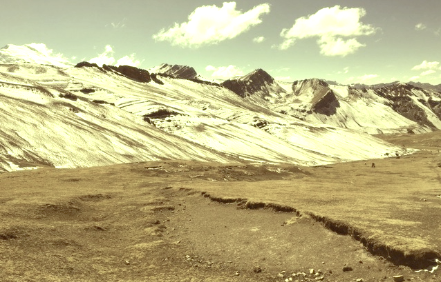
Vinicunca (5,200m- 17, 100ft)  also called Montaña de Siete Colores (The Mountain of Seven Colors) or Montaña de Colores  (Mountain of colors), sometimes known as Rainbow mountains, is a mountain in Peru, located in the Andes of Peru, in the . The Mountain of Seven Colors is a spectacular place, as if it were taken from another planet. It is found in the mountain range of Vilcanota and its striking natural coloration is due to the presence of sedimentary stones and minerals thanks to the erosion of wind and water. Ocres, reds, whites, yellows, greens and purples form a chromatic range that make Vinicunca a unique place in the world.
According to what some people of the area, this part of the mountain range was covered by glaciers for millennia. It seems that the disappearance of perpetual snow since the 1920's, made this colorful show. One of the peculiarities of this mountain for tourists (and they actually are too many!) who arrive there at dawn, is to discover Vinicunca covered with frost and entirely white (second photo above), without any of the colors that the brochures had promised! Then, as the sun warms up the atmosphere, the frost melts and reveals a land of multiple colors, a true rainbow mountain. One can imagine the reaction of the Incas to this phenomenon and why they immediately declared it sacred mountain.
There are two others Rainbow mountains or so called Colored Mountains on planet Earth : one in Canada, one in China.

Vintage postcards
Postcards became popular at the turn of the 20th century, especially for sending short messages to friends and relatives. They were collected right from the start, and are still sought after today by collectors of pop culture, photography, advertising, wartime memorabilia, local history, and many other categories. Postcards were an international craze, published all over the world. The Detroit Publishing Co. and Teich & Co. were two of the major publishers in the U.S, and sometimes individuals printed their own postcards as well. Yvon were the most famous in France. Many individual or anonymous publishers did exist around the world and especially in Africa and  Asia (Japan, Thailand, Nepal, China, Java) between 1920 and 1955. These photographer were mostly local notables, soldiers, official guides belonging to the colonial armies (british french, belgium...) who sometimes had rather sophisticated equipment and readily produced colored photograms or explorers, navigators, climbers (Vittorio Sella and the Archiduke of Abruzzi future king of Italy remains the most famous of them).
There are many types of collectible vintage postcards.
Hold-to-light postcards were made with tissue paper surrounded by two pieces of regular paper, so light would shine through. Fold-out postcards, popular in the 1950s, had multiple postcards attached in a long strip. Real photograph postcards (RPPCs) are photographs with a postcard backing.
Novelty postcards were made using wood, aluminum, copper, and cork. Silk postcards–often embroidered over a printed image–were wrapped around cardboard and sent in see-through glassine paper envelopes; they were especially popular during World War I.
In the 1930s and 1940s, postcards were printed on brightly colored paper designed to look like linen.
Most vintage postcard collectors focus on themes, like Christmas, Halloween, portraits of movie stars, European royalty and U.S. presidents, wartime imagery, and photos of natural disasters or natural wonders. Not to mention cards featuring colorful pictures by famous artists like Alphonse Mucha, Harrison Fisher, Ellen Clapsaddle, and Frances Brundage.

Friday, March 3, 2017

THE SASSOLUNGO IN VINTAGE POSTCARD 1930


VINTAGE POSTCARDS
The Sassolungo (3, 181m - 10,436 ft)
  Italy 

 Photo by Fotografia Ghedina, Cortina d'Ampezzo. Circa 1930's.

The Mountain
The Sassolungo (3, 181m - 10,436 ft) which means literally "Long Stone", also known as Langkofel in German is a summit of the Alps, in the Dolomites (Trentino-Alto Adige). The Sassolungo is a complex mountain with high slopes and many secondary summits : Sasso Levante or Punta Grohmann (3,126 m -10,256 ft) ;  Punta delle Cinque Dita or Fünffingerspitze (2,998 m - 9,8360 ft) ; Sasso Piatto  or Plattkofel (2,958 m - 9,7080 ft) and Campanile Comici.
Climbing
- 1869 - First climb by Paul Grohmann, Franz Innerkofler and Peter Salcher
- 1890 - First ascent of the Punta delle Cinque Dita by Robert Hans Schmitt and Johann Santner
- 1936 - North face by Gino Soldá and Augusto Bertoldi
- 1940 - North Pillar by E. Esposito and G. Butta
- 1940 - Ascension of Campanile Comici by Emilio Comici and Severino Casara
- 1959 - South Face of Torre Innerkofler by Dietrich Hasse and Sepp Schrott

Vintage postcards
Postcards became popular at the turn of the 20th century, especially for sending short messages to friends and relatives. They were collected right from the start, and are still sought after today by collectors of pop culture, photography, advertising, wartime memorabilia, local history, and many other categories.
Postcards were an international craze, published all over the world. The Detroit Publishing Co. and Teich & Co. were two of the major publishers in the U.S, and sometimes individuals printed their own postcards as well. Yvon were the most famous in France. Many individual or anonymous publishers did exist around the world and especially in Africa and  Asia (Japan, Thailand, Nepal, China, Java) between 1920 and 1955. These photographer were mostly local notables, soldiers, official guides belonging to the colonial armies (british french, belgium...) who sometimes had rather sophisticated equipment and readily produced colored photograms or explorers, navigators, climbers (Vittorio Sella and the Archiduke of Abruzzi future king of Italy remains the most famous of them).
There are many types of collectible vintage postcards.
Hold-to-light postcards were made with tissue paper surrounded by two pieces of regular paper, so light would shine through. Fold-out postcards, popular in the 1950s, had multiple postcards attached in a long strip. Real photograph postcards (RPPCs) are photographs with a postcard backing.
Novelty postcards were made using wood, aluminum, copper, and cork. Silk postcards–often embroidered over a printed image–were wrapped around cardboard and sent in see-through glassine paper envelopes; they were especially popular during World War I.
In the 1930s and 1940s, postcards were printed on brightly colored paper designed to look like linen.
Most vintage postcard collectors focus on themes, like Christmas, Halloween, portraits of movie stars, European royalty and U.S. presidents, wartime imagery, and photos of natural disasters or natural wonders. Not to mention cards featuring colorful pictures by famous artists like Alphonse Mucha, Harrison Fisher, Ellen Clapsaddle, and Frances Brundage.


Wednesday, January 25, 2017

CASTLE MOUNTAIN IN VINTAGE POSTCARD 1947


VINTAGE POSTCARD  1947
Castle Mountain or  Mount Eisenhower   (2,766m - 9,075ft)
Canada

 In Castle Mountain in Banff National Park, 1947, Hand-tinted photograph  


The mountain 
Castle Mountain (2,766m - 9,075ft) also named Mount Eisenhower between 1946 and 1979, is a mountain located within Banff National Park in the Canadian Rockies, approximately halfway between Banff and Lake Louise. It is the easternmost mountain of the Main Ranges in the Bow Valley and sits astride the Castle Mountain Fault which has thrust older sedimentary and metamorphic rocks forming the upper part of the mountain over the younger rocks forming its base. The mountain's castellated, or castle-like, appearance is a result of erosive processes acting at different rates on the peak's alternating layers of softer shale and harder limestone, dolomite and quartzite.
The mountain was named in 1858 by James Hector for its castle-like appearance. From 1946 to 1979 it was known as Mount Eisenhower in honour of the World War II general Dwight D. Eisenhower. Public pressure caused its original name to be restored, but a pinnacle on the southeastern side of the mountain was named Eisenhower Tower. Located nearby are the remains of Silver City, a 19th-century mining settlement, and the Castle Mountain Internment Camp in which persons deemed enemy aliens and suspected enemy sympathizers were confined during World War I.
While looking nearly inaccesible from the Trans-Canada Highway, the peak can be ascended from the backside on the northeastern slopes. The trail to Rockbound Lake leads hikers around the eastern side. The massif contains several high points including Helena Ridge (2,862 m - 9,390 ft), Stuart Knob (2,850 m - 9,350 ft) and Television Peak (2,970 m - 9,744 ft), the latter being named for the TV repeater located on top. Technicians use a helicopter rather than hiking the long ascent to the top.
James Hector, who accompanied the Palliser Expedition, encountered Castle Mountain in August 1858 while leading a side expedition to find the headwaters of the Bow River. He noted that it "...looks exactly like a gigantic castle" and named it Castle Mountain.  He also made the first recorded ascent of its slopes, but is not believed to have reached its summit.
The first climber to reach the top of Castle Mountain was Arthur P. Coleman, a professor at the University of Toronto, in 1884. Lawrence Grassi and P. Cerutti, both from Canmore, were the first to climb Eisenhower Tower in 1926.
In 1881, Joe Healy received some ore in trade from a First Nations person which was discovered to contain a relatively high silver content. The following year he settled at Castle Mountain as a prospector. News of Healy's ore soon spread; others began to arrive and the settlement of Silver City, situated near Castle Mountain, quickly developed. It was already thriving when the Canadian Pacific transcontinental railroad was built through the area in 1884.  Over three thousand people lived there at its height, but it was almost entirely abandoned in 1885 because the mines failed to yield a significant profit.
Situated nearby is Castle Mountain Internment Camp, a First World War internment camp where Ukrainian immigrants to Canada were confined. Life in the camps was often described as 'grim'; with its isolated location far from the roads of the time, the Castle Mountain camp was an ideal place to confine 'enemy aliens' and 'suspected enemy sympathisers'. The forced labour of these men helped build much of the infrastructure of Banff National Park. Internees were held at the Cave & Basin site during the winter months.
Construction began in 1910 at Castle Junction on a highway connecting British Columbia to Calgary that would, upon its completion in the early 1920s, make Castle Mountain more accessible to climbers, hikers and other tourists.


Vintage postcards
Postcards became popular at the turn of the 20th century, especially for sending short messages to friends and relatives. They were collected right from the start, and are still sought after today by collectors of pop culture, photography, advertising, wartime memorabilia, local history, and many other categories.
Postcards were an international craze, published all over the world. The Detroit Publishing Co. and Teich & Co. were two of the major publishers in the U.S, and sometimes individuals printed their own postcards as well. Yvon were the most famous in France. Many individual or anonymous publishers did exist around the world and especially in Africa and  Asia (Japan, Thailand, Nepal, China, Java) between 1920 and 1955. These photographer were mostly local notables, soldiers, official guides belonging to the colonial armies (british french, belgium...) who sometimes had rather sophisticated equipment and readily produced colored photograms or explorers, navigators, climbers (Vittorio Sella and the Archiduke of Abruzzi future king of Italy remains the most famous of them).
There are many types of collectible vintage postcards.
Hold-to-light postcards were made with tissue paper surrounded by two pieces of regular paper, so light would shine through. Fold-out postcards, popular in the 1950s, had multiple postcards attached in a long strip. Real photograph postcards (RPPCs) are photographs with a postcard backing.
Novelty postcards were made using wood, aluminum, copper, and cork. Silk postcards–often embroidered over a printed image–were wrapped around cardboard and sent in see-through glassine paper envelopes; they were especially popular during World War I.
In the 1930s and 1940s, postcards were printed on brightly colored paper designed to look like linen.
Most vintage postcard collectors focus on themes, like Christmas, Halloween, portraits of movie stars, European royalty and U.S. presidents, wartime imagery, and photos of natural disasters or natural wonders. Not to mention cards featuring colorful pictures by famous artists like Alphonse Mucha, Harrison Fisher, Ellen Clapsaddle, and Frances Brundage.

Sunday, January 22, 2017

MOUNT DAMAVAND IN VINTAGE POSTCARD, 1951


VINTAGE POSTCARD, 1951
Mount Damavand (5, 610m -18,410ft) 
Iran

 ©wanderingvertexescollection


The mountain 
Mount Damāvand  (5, 610m -18,410ft), in Persian  دماوند‎‎ , a potentially active volcano, is a stratovolcano which is the highest peak in Iran and the Middle East as well as the highest volcano in Asia (the Kunlun Volcanic Group in Tibet has a higher elevation than Damāvand, but are not considered to be volcanic mountains). It has a special place in Persian mythology and folklore.The origins and meaning of the word "Damavand" is unclear, yet some prominent researchers have speculated that it probably means "The mountain from which smoke and ash arises", alluding to the volcanic nature of the mountain. 
This peak is located in the middle of the Alborz range, adjacent to Varārū, Sesang, Gol-e Zard, and Mīānrūd. The mountain is located near the southern coast of the Caspian Sea, in Amol County, Mazandaran Province, 66 kilometres (41 miles) northeast of the city of Tehran. Mount Damāvand is the 12th most prominent peak in the world, and the second most prominent in Asia after Mount Everest. It is the highest volcanic mountain in Asia, and part of the Volcanic Seven Summits mountaineering challenge.
Damavand is a significant mountain in Persian mythology. It is the symbol of Iranian resistance against despotism and foreign rule in Persian poetry and literature. In Zoroastrian texts and mythology, the three-headed dragon Aži Dahāka was chained within Mount Damāvand, there to remain until the end of the world. In a later version of the same legend, the tyrant Zahhāk was also chained in a cave somewhere in Mount Damāvand after being defeated by Kāveh and Fereydūn. Persian poet Ferdowsi depicts this event in his masterpiece, the Shahnameh, in which the mountain is said to hold magical powers. Damāvand has also been named in the Iranian legend of Arash (as recounted by Bal'ami) as the location from which the hero shot his magical arrow to mark the border of Iran, during the border dispute between Iran and Turan. The famous poem Damāvand by Mohammad Taqī Bahār is also one fine example of the mountain's significance in Persian literature.
Mount Damavand is depicted on the reverse of the Iranian 10,000 rials banknote.
An anthropologist of Mazandaran Cultural Heritage and Tourism Department, Touba Osanlou, has said that a proposal has been put forward by a group of Iranian mountaineers to register the highest peak in the Middle East, Mount Damavand as a national heritage site. Mazandaran Cultural Heritage and Tourism Department has accepted the proposal, the Persian daily Jam-e Jam reported. 
Climbing routes 
The best major settlement for mountain climbers is the new Iranian Mountain Federation Camp in the village of Polour, located on the south of the mountain. There are at least 16 known routes to the summit, with varying levels of difficulty. Some of them are very dangerous and require rock 
climbing.

Vintage postcards
Postcards became popular at the turn of the 20th century, especially for sending short messages to friends and relatives. They were collected right from the start, and are still sought after today by collectors of pop culture, photography, advertising, wartime memorabilia, local history, and many other categories.
Postcards were an international craze, published all over the world. The Detroit Publishing Co. and Teich & Co. were two of the major publishers in the U.S, and sometimes individuals printed their own postcards as well. Yvon were the most famous in France. Many individual or anonymous publishers did exist around the world and especially in Africa and  Asia (Japan, Thailand, Nepal, China, Java) between 1920 and 1955. These photographer were mostly local notables, soldiers, official guides belonging to the colonial armies (british french, belgium...) who sometimes had rather sophisticated equipment and readily produced colored photograms or explorers, navigators, climbers (Vittorio Sella and the Archiduke of Abruzzi future king of Italy remains the most famous of them).
There are many types of collectible vintage postcards.
Hold-to-light postcards were made with tissue paper surrounded by two pieces of regular paper, so light would shine through. Fold-out postcards, popular in the 1950s, had multiple postcards attached in a long strip. Real photograph postcards (RPPCs) are photographs with a postcard backing.
Novelty postcards were made using wood, aluminum, copper, and cork. Silk postcards–often embroidered over a printed image–were wrapped around cardboard and sent in see-through glassine paper envelopes; they were especially popular during World War I.
In the 1930s and 1940s, postcards were printed on brightly colored paper designed to look like linen.
Most vintage postcard collectors focus on themes, like Christmas, Halloween, portraits of movie stars, European royalty and U.S. presidents, wartime imagery, and photos of natural disasters or natural wonders. Not to mention cards featuring colorful pictures by famous artists like Alphonse Mucha, Harrison Fisher, Ellen Clapsaddle, and Frances Brundage.