google.com, pub-0288379932320714, DIRECT, f08c47fec0942fa0 GRAVIR LES MONTAGNES... EN PEINTURE: 3000 - 4000 meters
Showing posts with label 3000 - 4000 meters. Show all posts

Thursday, June 30, 2022

PICO DEL TEIDE SKETCHED BY ALEXANDER VON HUMBOLDT


ALEXANDER VON HUMBOLDT (1769-1859), Pico del Teide (3, 718 m -12, 198 ft) Tenerife - Canari Islands - Spain   In  "Intérieur du Cratère du Pic de Teneriffe " Dessin, Alexander von Humboldt


ALEXANDER VON HUMBOLDT (1769-1859)
Pico del Teide (3, 718 m -12, 198 ft)
Tenerife - Canari Islands - Spain

 In  "Intérieur du Cratère du Pic de Teneriffe " Dessin, Alexander von Humboldt


The mountain
Pico del Teide (3,718m - 12,198 ft) (« Teide Peak") is a volcano on Tenerife in the Canary Islands, Spain. Before the 1495 Spanish colonization of Tenerife, the native Guanches called the volcano Echeyde, which in their legends referred to a powerful figure leaving the volcano, which could turn into hell. El Pico del Teide is the modern Spanish name.
Its summit is the highest point in Spain and the highest point above sea level in the islands of the Atlantic. If measured from its base on the ocean floor, it is at 7,500 m-24,600 ft the third highest volcano on a volcanic ocean island in the world after Mauna Kea and Mauna Loa in Hawaii. Its elevation makes Tenerife the tenth highest island in the world. It remains active: its most recent eruption occurred in 1909 from the El Chinyero vent on the northwestern Santiago rift.
Historical volcanic activity on the island is associated with vents on the Santiago or northwest rift (Boca Cangrejo in 1492, Montañas Negras in 1706, Narices del Teide or Chahorra in 1798 and El Chinyero in 1909) and the Cordillera Dorsal or northeast rift (Fasnia in 1704, Siete Fuentes and Arafo in 1705). The 1706 Montañas Negras eruption destroyed the town and principal port of Garachico, as well as several smaller villages.
In 1492, Christopher Columbus reported seeing "a great fire in the Orotava Valley" as he sailed past Tenerife on his voyage to discover the New World. This was interpreted as indicating that he had witnessed an eruption there. Radiometric dating of possible lavas indicates that in 1492 no eruption occurred in the Orotava Valley, but one did occur from the Boca Cangrejo vent.
The last summit eruption from Teide occurred about the year 850 CE, and this eruption produced the "Lavas Negras" that cover much of the flanks of the volcano.
About 150,000 years ago, a much larger explosive eruption occurred, probably of Volcanic Explosivity Index 5.
The United Nations Committee for Disaster Mitigation designated Teide a Decade Volcano because of its history of destructive eruptions and its proximity to several large towns, of which the closest are Garachico, Icod de los Vinos and Puerto de la Cruz. Teide, Pico Viejo and Montaсa Blanca form the Central Volcanic Complex of Tenerife.
In a publication of 1626, Sir Edmund Scory, who probably stayed on the island in the first decades of the 17th century, gives a description of Teide, in which he notes the suitable paths to the top and the effects the considerable height causes to the travellers, indicating that the volcano had been accessed via different routes before the 17th century. In 1715 the English traveler J. Edens and his party made the ascent and reported their observations in the journal of the Royal Society in London.
After the Enlightenment, most of the expeditions that went to East Africa and the Pacific had Teide as one of the most rewarding targets. The expedition of Lord George Macartney, George Staunton and John Barrow in 1792 almost ended in tragedy, as a major snowstorm and rain swept over them and they failed to reach the peak of Teide, just barely getting past Montaña Blanca.
During an expedition to Kilimanjaro, the German adventurer Hans Heinrich Joseph Meyer visited Teide in 1894 to observe ice conditions on the volcano. He described the two mountains as "two kings, one rising in the ocean and the other in the desert and steppes"
The volcano and its surroundings comprise Teide National Park, which has an area of 18,900 hectares (47,000 acres) and was named a World Heritage Site by UNESCO on June 28, 2007. Teide is the most visited natural wonder of Spain, the most visited national park in Spain and Europe and – by 2015 – the eighth most visited in the world, with some 3 million visitors yearly. A major international astronomical observatory is located on the slopes of the mountain.

The cartographer
Friedrich Wilhelm Heinrich Alexander von Humboldt was a Prussian geographer, naturalist, explorer, and influential proponent of Romantic philosophy and science. He was the younger brother of the Prussian minister, philosopher, and linguist Wilhelm von Humboldt (1767–1835). Humboldt's quantitative work on botanical geography laid the foundation for the field of biogeography. Humboldt's advocacy of long-term systematic geophysical measurement laid the foundation for modern geomagnetic and meteorological monitoring.
Between 1799 and 1804, Humboldt travelled extensively in Latin America, exploring and describing it for the first time from a modern scientific point of view. His description of the journey was written up and published in an enormous set of volumes over 21 years. Humboldt was one of the first people to propose that the lands bordering the Atlantic Ocean were once joined (South America and Africa in particular). Humboldt resurrected the use of the word cosmos from the ancient Greek and assigned it to his multi-volume treatise, Kosmos, in which he sought to unify diverse branches of scientific knowledge and culture. This important work also motivated a holistic perception of the universe as one interacting entity.
On their way back to Europe from Mexico on their way to the United States, Humboldt and his fellow scientist Aimé Bonpland stopped in Cuba for a While. After their first stay in Cuba of three months they returned the mainland at Cartagena de Indias (now in Colombia), a major center of trade in northern South America. Ascending the swollen stream of the Magdalena River to Honda and arrived in Bogotá on July 6, 1801 where they met Spanish botanist José Celestino Mutis, the head of the Royal Botanical Expedition to New Granada, staying there until September 8, 1801. Mutis was generous with his time and gave Humboldt access to the huge pictorial record he had compiled since 1783. Humboldt had hopes of connecting with the French sailing expedition of Baudin, now finally underway, so Bonpland and Humboldt hurried to Ecuador. They crossed the frozen ridges of the Cordillera Real, they reached Quito on 6 January 1802, after a tedious and difficult journey.
Their stay in Ecuador was marked by the ascent of Pichincha and their climb of Chimborazo, where Humboldt and his party reached an altitude of 19,286 feet (5,878 m). This was a world record at the time, but a thousand feet short of the summit. Humboldt's journey concluded with an expedition to the sources of the Amazon en route for Lima, Peru.
At Callao, the main port for Peru, Humboldt observed the transit of Mercury. On 9 November and studied the fertilizing properties of guano, rich in nitrogen, the subsequent introduction of which into Europe was due mainly to his writings.

___________________________________________
2022 - Wandering Vertexes...
by Francis Rousseau

Saturday, June 18, 2022

SUMMIT OF FUJIYAMA / 富士山 BY HIROSHI YOSHIDA / 吉田 博


HIROSHI YOSHIDA / 吉田 博 (1876-1950) Fujiyama / 富士山 (3, 776 m -12,389 ft) Japan  In Ten Views of Fuji- Summit of Fuji Series- woodblock Print


HIROSHI YOSHIDA / 吉田 博 (1876-1950)
Fujiyama / 富士山 (3, 776 m -12,389 ft)
Japan

In Ten Views of Fuji- Summit of Fuji Series- woodblock Print

 
The painter
Hiroshi Yoshida  / 吉田 博 (  (not to be confused with Toshi Yoshida) was born in 1876. He began his artistic training with his adoptive father in Kurume, Fukuoka prefecture. Around the age of twenty, he left Kurume to study with Soritsu Tamura in Kyoto, subsequently moving to Tokyo and the tutelage of Shotaro Koyama. Yoshida studied Western-style painting, winning many exhibition prizes and making several trips to the United States, Europe and North Africa selling his watercolors and oil paintings. In 1902, he played a leading role in the organization of the Meiji Fine Arts Society into the Pacific Painting Association. His work was featured in the exhibitions of the state-sponsored Bunten and Teiten. While highly successful as an oil painter and watercolor artist, Yoshida turned to printmaking upon learning of the Western world’s infatuation with ukiyo-e.
Following the Great Kanto Earthquake of 1923, Yoshida embarked on a tour of the United States and Europe, painting and selling his work. When he returned to Japan in 1925, he started his own workshop, specializing in landscapes inspired both by his native country and his travels abroad. Yoshida often worked through the entire process himself: designing the print, carving his own blocks, and printing his work. His career was temporarily interrupted by his sojourn as a war correspondent in Manchuria during the Pacific War. Although he designed his last print in 1946, Yoshida continued to paint with oils and watercolors up until his death in 1950.
Yoshida was widely traveled and knowledgeable of Western aesthetics, yet maintained an allegiance to traditional Japanese techniques and traditions. Attracted by the calmer moments of nature, his prints breathe coolness, invite meditation, and set a soft, peaceful mood. All of his lifetime prints are signed “Hiroshi Yoshida” in pencil and marked with a jizuri (self-printed) seal outside of the margin. Within the image, most prints are signed “Yoshida” with brush and ink beside a red “Hiroshi” seal.


The mountain
The legendary Mount Fuji or Fujiyama (富士山) i  located on Honshu Island and is the highest mountain peak in Japan at 3,776.24 m (12,389 ft). Several names are attributed to it: "Fuji-san", "Fujiyama" or, redundantly, "Mt. Fujiyama". Usually Japanese speakers refer to the mountain as "Fuji-san". The other Japanese names for Mount Fuji, have become obsolete or poetic like: Fuji-no-Yama (ふじの山 - The Mountain of Fuji), Fuji-no-Takane (ふじの高嶺- The High Peak of Fuji), Fuyō-hō (芙蓉峰 - The Lotus Peak), and Fugaku (富岳/富嶽), created by combining the first character of 富士, Fuji, and 岳, mountain.
Mount Fuji is an active stratovolcano that last erupted in 1707–08. Mount Fuji lies about 100 kilometres (60 mi) south-west of Tokyo, and can be seen from there on a clear day.
Mount Fuji's exceptionally symmetrical cone, which is snow-capped several months a year, is a well-known symbol of Japan and it is frequently depicted in art and photographs, as well as visited by sightseers and climbers. Mount Fuji is one of Japan's Three Holy Mountains (三霊山) along with Mount Tate and Mount Haku. It is also a Special Place of Scenic Beauty and one of Japan's Historic Sites.
It was added to the World Heritage List as a Cultural Site on June 22, 2013. As per UNESCO, Mount Fuji has “inspired artists and poets and been the object of pilgrimage for centuries”. UNESCO recognizes 25 sites of cultural interest within the Mt. Fuji locality. These 25 locations include the mountain itself, Fujisan Hongū Sengen Shrine and six other Sengen shrines, two lodging houses, Lake Yamanaka, Lake Kawaguchi, the eight Oshino Hakkai hot springs, two lava tree molds, the remains of the Fuji-kō cult in the Hitoana cave, Shiraito Falls, and Miho no Matsubara pine tree grove; while on the low alps of Mount Fuji lies the Taisekiji temple complex, where the central base headquarters of Nichiren Shoshu Buddhism is located.

_______________________________

2022 - Wandering Vertexes...
by Francis Rousseau

Sunday, May 1, 2022

MOUNT HAKU / 白山 BY HIROSHIGE II / 二代目 歌川広重

HIROSHIGE II (1826 - 1869) Mount Haku /白山, (2,702.2 m -8,865 ft Japan ( Honshu)   In Mount Haku, Kaga Province,  Woodblock Print,  1862- in Sixty-eight Views of the Various Provinces, 1862


HIROSHIGE II  /  二代目 歌川広重 (1826 - 1869)
Mount Haku /白山, (2,702.2 m -8,865 ft
Japan ( Honshu)

 In Mount Haku, Kaga Province,  Woodblock Print,  1862- in Sixty-eight Views of the Various Provinces, 1862

The mountain
Mount Haku /白山 (2,702.2 m -8,865 ft), meaning"White Mountain", or Mount Hakusan (commonly referred to as simply Hakusan), is a dormant stratovolcano in Japan. It is located on the borders of Gifu and Ishikawa, on the island of Honshu. Mount Haku is thought  to have first been active 300,000 to 400,000 years ago, with the most recent eruption occurring in 1659. Along with Mount Tate and Mount Fuji, it is one of Japan's "Three Holy Mountains". The mountain's tallest peak, Gozenga-mine (御前峰), is the one that gives the mountain its height of 2,702 m (8,865 ft). Along with Ken-ga-mine (剣ヶ峰), which is 2,677 m (8,783 ft), and Ōnanji-mine (大汝峰), which is 2,648 m (8,688 ft), the three peaks are considered "Mount Haku's Three Peaks" (白山三峰 Hakusan San-mine). Mount Bessan and Mount Sannomine are sometimes included and called "Mount Haku's Five Peaks" (白山五峰). Because it is very prominent and clearly visible from the nearby coast, even after the surrounding mountains have lost their snow, Mount Haku still appears white, which is one explanation for the mountain's name, which means "white mountain." It is also the westernmost mountain in Japan that is over 2,000 m (6,562 ft) in height. Taichō, a mountain Shugendo monk, first climbed Mount Hakusan in 717. For hundreds of years, people have come to Haku for prayers (白山信仰). A branch shrine of Shirayama Hime Shrine, which served as the supreme shrine for Kaga Province, is on the mountain. The Shirayama Hime Shrine is the main shrine (総本社) of approximately 2,000 Hakusan shrines (白山神社) in Japan. In 1980 an area of 48,000 ha was designated a UNESCO Man and the Biosphere Reserve. Mount Haku was designated as a quasi-national park in 1955. It became a national park in 1962 and was renamed Hakusan National Park. Because the central part of the mountain has much precipitous terrain, there are very few roads and, as a result, little human intrusion into the area. Also limiting human intrusion is the designation of the park as a Wildlife Protection Area, covering over 38,061 ha. The park stretches beyond the mountain's borders into Toyama Prefecture.


The artist
Hiroshige II (二代目 歌川広重) 1826 – 17 September 1869) was a Japanese designer of ukiyo-e art. He inherited the name Hiroshige II following the death in 1858 of his master Utagawa Hiroshige (歌川 広重), whose daughter he married. In 1865 he moved from Edo to Yokohama after dissolving his marriage and began using the name Kisai Risshō (喜斎立祥). His work so resembles that of his master that scholars have often confused them.
Born Suzuki Chinpei (鈴木鎮平) in 1826, it is said that he was born to a fireman, as was his master Utagawa Hiroshige (歌川 広重), to whom he became apprenticed under the name Shigenobu at an unknown age. His earliest known work is the illustrations for a book called Twenty-four Paragons of Japan and China from 1849. Hiroshige II produced a large number of commissioned work in the 1850s in the style of the elder Hiroshige, and often signed his work Ichiryūsai mon ("student of Ichiryūsai", another art name of Hiroshige I's), and from c. 1853 to 1858 simply as Ichiryūsai. In 1858, he married Hiroshige I's daughter Otatsu after the master's death and inherited the Hiroshige name, as well as the names Ichiryūsai and Ryūsai.
Utagawa Hiroshige (歌川 広重) took on few students; Hiroshige II was the most successful of these. His works have often been confounded with those of his master, which they resemble closely in style, subject, and signature. Early Western scholars did not even recognize him as a separate artist. Another pupil of the first Hiroshige, Shigemasa, later married the master's daughter, Otatsu, and also began using the name Hiroshige; this artist now is known as Hiroshige III.


__________________________________________

2022 - Wandering Vertexes...
by Francis Rousseau

Sunday, April 17, 2022

GULA MONS (ON VENUS) BY NASA MAGELLAN MISSION


NASA MAGELLAN MISSION (1989-1994) Gula Mons (3000m/3km -9,843ft/1.9mi) Planet Venus (Solar system /The Milky Way Galaxy)

NASA MAGELLAN MISSION (1989-1994)
Gula Mons (3000m/3km -9,843ft/1.9mi)
Planet Venus (Solar system /The Milky Way Galaxy)


The mountain
Gula Mons (3000m/3km -9,843ft/1.9mi high and 276km diameter), named after the Mesopotamian Goddess of Healing, is a shield volcano on planet Venus in western Eistla Regio, located south of Sedna Planitia, west of Bereghinya Planitia and east of Guinervere Planitia, at 21,9° N et 359,1° E.
Its main feature is a NE-SW-oriented rift-like fracture set connecting two summit calderas. There is also a structure which links the northern caldera and ridge system to Idem Kuva corona located NW of Gula Mons. Radially spreading lava flows which have digitate and broad sheet-like forms extend from the summit, including radar-dark flows which overlay several older lava deposits. Radial and circumferential fractures are present on the flanks.

The image capturer
Gula Mons is displayed in this computer-simulated view of the surface of Venus. The viewpoint is located 110 kilometers (68 miles) southwest of Gula Mons at the same elevation as the summit, 3 kilometers (1.9 miles) above Eistla Regio. Lava flows extend for hundreds of kilometers across the fractured plains. The view is to the northeast with Gula Mons appearing at the center of the image. Gula Mons, a 3 kilometer (1.9 mile) high volcano, is located at approximately 22 degrees north latitude, 359 degrees east longitude in western Eistla Regio. Magellan synthetic aperture radar data is combined with radar altimetry to produce a three-dimensional map of the surface. Rays cast in a computer intersect the surface to create a three-dimensional perspective view. Simulated color and a digital elevation map developed by the U.S. Geological Survey are used to enhance small-scale structure. The simulated hues are based on color images recorded by the Soviet Venera 13 and 14 spacecraft. The image was produced by the JPL Multimission Image Processing Laboratory and is a single frame from a video released at the March 5, 1991, JPL news conference.  
- More about NASA Magellan Mission 

 
___________________________________________
2022 - Wandering Vertexes...
by Francis Rousseau

Saturday, April 9, 2022

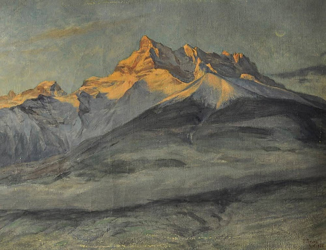
DENTS DU MIDI PAINTED BY FREDERIC ROUGE


FREDERIC ROUGE (1867-1950) The Dents du Midi  (3,114 m to 3,257 m -10,216 ft to10,685 ft)  Switzerland   In Les Les-Dents du Midi en hiver, 1906, Huile sur toile, Fondation Frédéric Rouge

FREDERIC ROUGE (1867-1950)
The Dents du Midi  (3,114 m to 3,257 m -10,216 ft to10,685 ft) 
Switzerland

 In Les Les-Dents du Midi en hiver, 1906, Huile sur toile, Fondation Frédéric Rouge


The painter
Frederic Rouge was born in Aigle (Switzerland), on 27 April 1867. His parents owned a small shoe factory. After school, he attended the Fine Arts College in Basel for a year, coming first of his class at the end of the course. Then, after a while studying with the history painter Vigier, he came back home to live with his parents. To perfect his technique, the artist spent three consecutive winters at the Julian Academy in Paris "where Professor Boulanger, exacting and irascible, was hard to please". In 1903, Frederic Rouge settled in Ollon, not far from Aigle, in a pleasant house called "The Cedars". Today Ollon is still a large village surrounded by orchards and vineyards bathed in sunshine, its dense forests teeming with wildlife, and where the Alpine scenery reigns supreme.
He wholeheartedly loved this region which provided him with so many subjects of inspiration, and whose every season, scene and mood he rendered so faithfully.
Frederic Rouge was suffering from paralysis when he died on 13 February 1950. All his life he had remained unassuming, an honest man and a great artist, true to his ideals, a citizen devoted to the cause of liberty - perhaps not the best way to make one's fortune, even for a painter of talent !

The mountains
The Dents du Midi (Teeth of the south) (3,114 m to 3,257 m -10,216 ft to10,685 ft) are mountain range, 3 kilometers long, located in the Chablais Alps in the canton of Valais in Switzerland. Overlooking the valley of Illiez and Rhône Valley on south, they face the lake Salanfe, an artificial reservoir, and are part of the geological whole massif Giffre.
The name "Dents du Midi" is recent. The people formerly called them "Dents Tsallen". It was only towards the end of the19e century that the name "Dents du Midi" came officially.
Each « tooth » had several names over the centuries and according to its geological evolution.
- The "Cime de l'Est" (3,178 meters) called "Mont Novierre" before the mid-17th century, and "Mont Saint-Michel "after landslides in 1635 and 1636 and finally "Dent Noire" (until the 19th century).
- The "Dent Jaune" (3,186 m) was called the "Dent Rouge" until 1879.
- The "Doigt de Champéry" (in 1882) and then the Doigt Salanfe (in 1886) turned just into "Les Doigts" (Fingers) (3,205 m and 3210 m).
- The "Haute Cime" (3,257 m) also had many names : "Dent de L’ouest" (until 1784)an then "Dent du Midi", "Dent de Tsallen" and "Dent de Challent."
- As for l’Eperon (3,114 m) (The Spur), it is assumed that there were two peaks but a landslide in the Middle Ages significantly changed its crest.
- The Forteresse (3,164 m) and the Cathedral (3,160 m) have not changed names.
The evolution of this massif continues nowadays. So on the morning of 30 October 2006, a volume of 1 million m3 of rock broke away from the edge of the Haute Cime and slid down the slope to an altitude of about 3000 m. The event did not present danger to the nearby village of Val-d'Illiez but roads and trails were closed for security reasons. According to the cantonal geologist, the landslide was caused by the thawing of rocks, helped by warm summers of recent years. 

____________________________________
2022 - Wandering Vertexes...
by Francis Rousseau


Monday, January 17, 2022

FUJIYAMA BY KIYOSHI SAITO

KIYOSHI SAITO / 斎藤 清 (1907-1997) Fujiyama / 富士山 (3, 776 m -12,389 ft) Japan  In Mt. Fuji in Sunset Glow, 1986, woodcut , 45.2 x 61.5 cm, Private collection

KIYOSHI SAITO / 斎藤 清 (1907-1997)
Fujiyama / 富士山 (3, 776 m -12,389 ft)
Japan

In Mt. Fuji in Sunset Glow, 1986, woodcut , 45.2 x 61.5 cm, Private collection

The painter
Kiyoshi Saitō (斎藤 清) born in Aizubange, Fukushima) was a sōsaku-hanga artist in 20th-century Japan. In 1938, he issued his first prints in his now famous "Winter in Aizu" series. Saitō was one of the first Japanese printmaking artists to have won at the São Paulo Biennale in 1951. Saitō's early works depict villages populated with local Japanese with a high degree of realism and three-dimensionality. His more mature works merge modern elements with Japanese tradition. His prints feature architecture and plant life flattened in two-dimensionality.  He spent time in Paris, and did a series there. Kiyoshi Saito’s woodblock prints titled “Autumn” are considered extremely rare and valuable.


The mountain

The legendary Mount Fuji or Fujiyama (富士山) is located on Honshu Island and is the highest mountain peak in Japan at 3,776.24 m (12,389 ft). Several names are attributed to it: "Fuji-san", "Fujiyama" or, redundantly, "Mt. Fujiyama". Usually Japanese speakers refer to the mountain as "Fuji-san". The other Japanese names for Mount Fuji, have become obsolete or poetic like: Fuji-no-Yama (ふじの山 - The Mountain of Fuji), Fuji-no-Takane (ふじの高嶺- The High Peak of Fuji), Fuyō-hō (芙蓉峰 - The Lotus Peak), and Fugaku (富岳/富嶽), created by combining the first character of 富士, Fuji, and 岳, mountain.
Mount Fuji is an active stratovolcano that last erupted in 1707–08. Mount Fuji lies about 100 kilometres (60 mi) south-west of Tokyo, and can be seen from there on a clear day.
Mount Fuji's exceptionally symmetrical cone, which is snow-capped several months a year, is a well-known symbol of Japan and it is frequently depicted in art and photographs, as well as visited by sightseers and climbers.
Mount Fuji is one of Japan's Three Holy Mountains (三霊山) along with Mount Tate and Mount Haku. It is also a Special Place of Scenic Beauty and one of Japan's Historic Sites.
It was added to the World Heritage List as a Cultural Site on June 22, 2013. As per UNESCO, Mount Fuji has “inspired artists and poets and been the object of pilgrimage for centuries”. UNESCO recognizes 25 sites of cultural interest within the Mt. Fuji locality. These 25 locations include the mountain itself, Fujisan Hongū Sengen Shrine and six other Sengen shrines, two lodging houses, Lake Yamanaka, Lake Kawaguchi, the eight Oshino Hakkai hot springs, two lava tree molds, the remains of the Fuji-kō cult in the Hitoana cave, Shiraito Falls, and Miho no Matsubara pine tree grove; while on the low alps of Mount Fuji lies the Taisekiji temple complex, where the central base headquarters of Nichiren Shoshu Buddhism is located.

______________________________

2022 - Wandering Vertexes...
by Francis Rousseau

Thursday, October 21, 2021

MONTE CIVETTA PAINTED BY ELIJAH WALTON


ELIJAH WALTON (1832-1880), Monte Civetta (3,220 m - 10, 580 ft) Italy  In Dolomites - in Spring. Civetta from Forcella Staulanza (North East), 1875 oil on canvas, 38 x 183 cm
 
ELIJAH WALTON (1832-1880)
Monte Civetta (3,220 m - 10, 580 ft)
Italy

In Dolomites - in Spring. Civetta from Forcella Staulanza (North East), 1875 oil on canvas, 38 x 183 cm.


The mountain
Monte Civetta (3,220 m - 10, 580 ft) is a prominent and major mountain of the Dolomites, in the Province of Belluno in northern Italy. Its north-west face can be viewed from the Taibon Agordino valley, and is classed as one of the symbols of the Dolomites. The mountain is thought to have been first climbed by Simeone di Silvestro in 1855, which, if true, makes it the first major Dolomite peak to be climbed. The north-western face, with its 1,000-metre-high cliff, was first climbed in 1925 by Emil Solleder and Gustl Lettenbauer. It is historically considered the first "sixth grade" in six-tier scale of alpinistic difficulties proposed by Willo Welzenbach (corresponding to 5.9). Thirty years later UIAA used this as a basis for its grading system. The famed Svan mountain climber Mikhail Khergiani died in a climbing accident on Monte Civetta in 1969.

The artist
The British landscapist, Elijah Walton is best known for his landscapes of mountains in the Alps. Due to the poorness of his family, without the help of one or two friends he would have been unable to study art, for which his talent was soon exhibited. After passing some years at the art academy in Birmingham, he became at the age of eighteen a student at the Royal Academy Schools in London, where he had already exhibited a picture. There he worked assiduously, drawing from the antique and from life. Nearly ten years later an accidental circumstance revealed to a friend his capabilities in mountain landscape, and in 1860, immediately after his marriage, he went to Switzerland. Thence he proceeded to Egypt, where unhappily his wife died of dysentery near the second cataract. He remained in the east, spending some time in Syria and at Constantinople, till the spring of 1862, when he returned for a short time to London. But for the next five years he was much abroad, working either in the Alps or in Egypt. His sketching tours then became rarer and shorter, though he visited Greece, Norway, and the Alps. At first he resided at Staines, then removed to the neighbourhood of Bromsgrove, living most of the time at the Forelands, near that town. In 1872 his wife died, and the loss permanently affected his health. He died on 25 August 1880 at his residence Beacon Farm, Lickey near Bromsgrove in Worcestershire, leaving three sons. Walton's life was bound up in his art. He worked both in oils and in watercolours, but was more successful with the latter. Most thorough and conscientious in the study both of form and of colour, he delighted especially in mountain scenery and in atmospheric effects, such as an Alpine peak breaking through the mists, or a sunset on the Nile. Few men have equalled him in the truthful rendering of rock structure and mountain form. His pictures were much appreciated by lovers of nature; but as those of small size sold better than larger and more highly finished works, this fostered a tendency to mannerisms.

___________________________________________
2021 - Wandering Vertexes...
by Francis Rousseau

Friday, October 8, 2021

FUJIYAMA / 富士山 BY TSUCHIYA KOITSU /土屋光逸


Tsuchiya Koitsu / 土屋光逸 (1870-1949) Fujiyama / 富士山 (3, 776 m -12,389 ft) Japan  In Fuji from Lake Motosu, woodblock pirnt, 1934

TSUCHIYA KOITSU / 土屋光逸 (1870-1949)
Fujiyama / 富士山 (3, 776 m -12,389 ft)
Japan

In Fuji from Lake Motosu, woodblock print, 1934


The artist

Tsuchiya Koitsu (土屋光逸) was an important artist in the Shin-hanga movement. He trained under the ukiyo-e master Kobayashi Kiyochika for 19 years, and initially focused on works depicting scenes from the First Sino-Japanese War. In 1931, at the age of 60, he began work for Shōzaburō Watanabe and his art publishing establishment which also published the work of artists like Kawase Hasui and Yoshida Hiroshi. His later work incorporated light effects to increase the emotional impact of his art.
Born on September 23, 1870, in Hamamatsu, Shizuoka, Japan. His birth name was either Koichi or Sahei. He moved to Tokyo at age 15. He first had an apprenticeship for the woodblock carver Matsuzaki, but soon became a student of ukiyo-e master Kiyochika Kobayashi. He worked for Kiyochika for 19 years and lived in his house.
He initially published prints made during the First Sino-Japanese War, before developing his skill with dramatic light effects, learned from Kiyochika. Koitsu published through the Watanabe publishing house after Watanabe and Koitsu met at an exhibition commemorating the 17th anniversary of Kiyochika's death. He also produced prints for publishers Doi Sadaichi, Kawaguchi, Baba Nobuhiko, Tanaka Shobido, and Takemura.

The mountain
This is the legendary Mount Fuji or Fujiyama (富士山).
It is located on Honshu Island and is the highest mountain peak in Japan at 3,776.24 m (12,389 ft). Several names are attributed to it: "Fuji-san", "Fujiyama" or, redundantly, "Mt. Fujiyama". Usually Japanese speakers refer to the mountain as "Fuji-san". The other Japanese names for Mount Fuji, have become obsolete or poetic like: Fuji-no-Yama (ふじの山 - The Mountain of Fuji), Fuji-no-Takane (ふじの高嶺- The High Peak of Fuji), Fuyō-hō (芙蓉峰 - The Lotus Peak), and Fugaku (富岳/富嶽), created by combining the first character of 富士, Fuji, and 岳, mountain.
Mount Fuji is an active stratovolcano that last erupted in 1707–08. Mount Fuji lies about 100 kilometres (60 mi) south-west of Tokyo, and can be seen from there on a clear day.
Mount Fuji's exceptionally symmetrical cone, which is snow-capped several months a year, is a well-known symbol of Japan and it is frequently depicted in art and photographs, as well as visited by sightseers and climbers.
Mount Fuji is one of Japan's Three Holy Mountains (三霊山) along with Mount Tate and Mount Haku. It is also a Special Place of Scenic Beauty and one of Japan's Historic Sites.
It was added to the World Heritage List as a Cultural Site on June 22, 2013. As per UNESCO, Mount Fuji has “inspired artists and poets and been the object of pilgrimage for centuries”. UNESCO recognizes 25 sites of cultural interest within the Mt. Fuji locality. These 25 locations include the mountain itself, Fujisan Hongū Sengen Shrine and six other Sengen shrines, two lodging houses, Lake Yamanaka, Lake Kawaguchi, the eight Oshino Hakkai hot springs, two lava tree molds, the remains of the Fuji-kō cult in the Hitoana cave, Shiraito Falls, and Miho no Matsubara pine tree grove; while on the low alps of Mount Fuji lies the Taisekiji temple complex, where the central base headquarters of Nichiren Shoshu Buddhism is located.
______________________________

2021 - Wandering Vertexes...
by Francis Rousseau

Thursday, September 16, 2021

THE EIGER SKETCHED BY JOHN SINGER SARGENT

JOHN SINGER SARGENT (1856-1925) The Eiger (3,970 m -13,020 ft) Switzerland  In Eiger from Mürren (from “Splendid Mountain Watercolours” Sketchbook), 40.6 x 27.6 cm, Watercolor and graphite, The MET (Gift of Mrs. Francis Ormond, 1950. Public Domain.

JOHN SINGER SARGENT (1856-1925)
The Eiger (3,970 m -13,020 ft)
Switzerland


In Eiger from Mürren (from Splendid Mountain Watercolours Sketchbook),
Watercolor and graphite, 40.6 x 27.6 cm,
The MET (Gift of Mrs. Francis Ormond, 1950. Public Domain.


The painter
John Singer Sargent was an American artist who created roughly 900 oil paintings and more than 2,000 watercolors, as well as countless sketches and charcoal drawings. His oeuvre documents worldwide travel, from Venice to the Tyrol, Switzerland, Corfu, the Middle East, Montana, Maine, and Florida.
He was trained in Paris prior to moving to London. Sargent enjoyed international acclaim as a portrait painter, but in later life he expressed ambivalence about the restrictions of formal portrait work, and devoted much of his energy to mural painting and working en plein air. He lived most of his life in Europe. Each destination offered pictorial stimulation and treasure. Even at his leisure, in escaping the pressures of the portrait studio, he painted with restless intensity, often painting from morning until night. His hundreds of watercolors of Venice are especially notable, many done from the perspective of a gondola. His colors were sometimes extremely vivid and as one reviewer noted, "Everything is given with the intensity of a dream." In the Middle East and North Africa Sargent painted Bedouins, goatherds, and fisherman. In the last decade of his life, he produced many watercolors in Maine, Florida, and in the American West, of fauna, flora, and native peoples.
With his watercolors, Sargent was able to indulge his earliest artistic inclinations for nature, architecture, exotic peoples, and noble mountain landscapes. And it is in some of his late works where one senses Sargent painting most purely for himself. His watercolors were executed with a joyful fluidness. His first major solo exhibit of watercolor works was at the Carfax Gallery in London in 1905. In 1909, he exhibited eighty-six watercolors in New York City, eighty-three of which were bought by the Brooklyn Museum. Evan Charteris wrote in 1927: 'To live with Sargent's water-colours is to live with sunshine captured and held, with the luster of a bright and legible world, 'the refluent shade' and 'the Ambient ardours of the noon.'
Although not generally accorded the critical respect given Winslow Homer, perhaps America's greatest watercolorist, scholarship has revealed that Sargent was fluent in the entire range of opaque and transparent watercolor technique, including the methods used by Homer.


The mountain
The Eiger (3,970m- 13,020 ft) is located in the Bernese Alps, overlooking Grindelwald and Lauterbrunnen in the Bernese Oberland, just north of the main watershed and border with Valais. It is the easternmost peak of a ridge crest that extends across the Mönch to the Jungfrau at (4,158 m-13,642 ft), constituting one of the most emblematic sights of the Swiss Alps. While the northern side of the mountain rises more than 3,000m -10,000 ft above the two valleys of Grindelwald and Lauterbrunnen, the southern side faces the large glaciers of the Jungfrau-Aletsch area, the most glaciated region in the Alps. The most notable feature of the Eiger is its 1,800-metre-high - 5,900 ft north face of rock and ice, named Eigerwand or Nordwand, which is the biggest north face in the Alps. This huge face towers over the resort of Kleine Scheidegg at its base, on the homonymous pass connecting the two valleys.
The first ascent of the Eiger was made by Swiss guides Christian Almer and Peter Bohren and Irishman Charles Barrington, who climbed the west flank on August 11, 1858.
The north face, considered amongst the most challenging and dangerous ascents, was first climbed in 1938 by an Austrian-German expedition with Anderl Heckmair, Ludwig Vцrg, Heinrich Harrer and Fritz Kasparek. The Eiger has been highly-publicized for the many tragedies involving climbing expeditions.
In 1973 : first all female ascent of the face by Wanda Rutkiewicz, Danuta Gellner-Wach and Stefania Egierszdorff. All Polish.
In June 2006, François Bon and Antoine Montant make the first speedflying descent of the Eiger
Since 1935, at least sixty-four climbers have died attempting the north face, earning it the German nickname Mordwand, literally "murder(ous) wall"—a pun on its correct title of Nordwand (North Wall).
Although the summit of the Eiger can be reached by experienced climbers only, a railway tunnel runs inside the mountain, and two internal stations provide easy access to viewing-windows carved into the rock face. They are both part of the Jungfrau Railway line, running from Kleine Scheidegg to the Jungfraujoch, between the Mцnch and the Jungfrau, at the highest railway station in Europe. The two stations within the Eiger are Eigerwand (behind the north face) and Eismeer (behind the south face), at around 3,000 metres.
The Eiger is mentioned in records dating back to the 13th century, but there is no clear indication of how exactly the peak gained its name. The three mountains of the ridge are commonly referred to as the Virgin (German: Jungfrau – translates to "virgin" or "maiden"), the Monk (Mцnch), and the Ogre (Eiger; the standard German word for ogre is Oger). The name has been linked to the Latin term acer, meaning "sharp" or "pointed", but more commonly to the German eigen, meaning "own".

___________________________________________

2021 - Wandering Vertexes...
by Francis Rousseau


Wednesday, August 11, 2021

DIE HOCHFEILER OR GRAN PILASTRO BY AUGUST STRINDBERG


-AUGUST STRINDBERG (1849-1912) The Hochfeiler or Gran Pilastro  (3,510 m -11,520 ft) Austria - Italy border In Alpine Landscape Austria, oil on canvas , Priva te collection

AUGUST STRINDBERG (1849-1912)
The Hochfeiler or Gran Pilastro (3,510 m -11,520 ft)
Austria - Italy border
 
In Alpine Landscape Austria, oil on canvas, Private collection

The artist
Johan August Strindberg known to be a famous  Swedish playwright was also  a novelist a poet, an essayist and a painter. Strindberg, something of a polymath, was also a telegrapher, theosophist, photographer and alchemist!  Painting and photography offered vehicles for his belief that chance played a crucial part in the creative process. Strindberg's paintings were unique for their time, and went beyond those of his contemporaries for their radical lack of adherence to visual reality. The 117 paintings that are acknowledged as his were mostly painted within the span of a few years, and are now seen by some as among the most original works of 19th-century art. Today, his best-known pieces are stormy, expressionist seascapes, selling at high prices in auction houses. Though Strindberg was friends with Edvard Munch and Paul Gauguin, and was thus familiar with modern trends, the spontaneous and subjective expressiveness of his landscapes and seascapes can be ascribed also to the fact that he painted only in periods of personal crisis. Anders Zorn also did a portrait.
Strindberg's interest in photography resulted, among other things, in a large number of arranged self-portraits in various environments, which now number among the best-known pictures of him. Strindberg also embarked on a series of camera-less images, using an experimental quasi-scientific approach. He produced a type of photogram that encouraged the development and growth of crystals on the photographic emulsion, sometimes exposed for lengthy periods to heat or cold in the open air or at night facing the stars. The suggestiveness of these, which he called Celestographs, provided an object for contemplation, and he noted: "Today, in these days of x-rays, the miracle was that neither a camera nor a lens was used. For me this means a great opportunity to demonstrate the real circumstances by means of my photographs made without a camera and lens, recording the firmament in early spring 1894."
His interest in the occult in the 1890s finds sympathy with the chance quality of these images, but for him they are also scientific. In 1895 Strindberg met Camille Flammarion and became a member of the Société astronomique de France. He gave some of his experimental astronomical photographs to the Society

The mountain
The Hochfeiler 3,510 m (11,520 ft) called Gran Pilastro in italian is a mountain, 3,510 metres high, and the highest peak in the Zillertal Alps on the border between Tyrol, Austria, and South Tyrol, Italy.

___________________________________________

2021 - Wandering Vertexes...
by Francis Rousseau

Wednesday, July 28, 2021

THE MONT BLANC PAINTED BY JEAN-ANTOINE LINCK


JEAN-ANTOINE LINCK (1766-1843)
The Mont Blanc (4,808.73 m -15,777 ft)
France-Italy border

In Vue du Mont blanc à partir du Col de Balme, Estampe, 50 x50cm, 
Musée Alpin de Chamonix-Mont-Blanc


About this picture
This print represents the Chamonix valley seen from the Col de Balme. This point of view allows the spectator to embrace the major part of the Mont-Blanc massif and the valley bottom by following the course of the Arve. Jean-Antoine Linck offers a relatively realistic panorama, sometimes exaggerating the bristling of summits and seracs. In the foreground, the artist has placed a few figures who seem to be tourists in awe of the landscape accompanied by a guide leaning against the border post with his two mules. Linck was trained in Geneva in his father's workshop in the context of the "Fabrique" which brings together watchmakers, jewelers and painters on enamel. It was in this dynamic artistic environment of the second half of the 18th century that the first engravers appeared who made the Chamonix valley known through their watercolor prints. A real industry of landscape engraving is then set up. Linck is one of the greatest representatives of this artistic movement linked to the rise of alpine tourism and a new craze for the landscape. He creates high-quality etched works, very popular with travelers, which he sells in his Geneva boutique. In his "Manual of the traveler in Switzerland" of 1818, Ebel moreover advises the latter in order to find the best artists. He quotes Linck in particular and specifies that this print was worth 18 pounds, a fairly large sum for the time. Despite everything, the print is reproducible and cheaper than a painting. It therefore lends itself perfectly to the request of visitors to take with them views of the regions visited.

The artist
Jean-Antoine Linck, is a swiss painter and draftsman who lived and worked at the end of the 18th century and beginning of 19th century, at the time nature and mountains were up to date in high society in Switzerland and France.He is the son of Jean-Conrad, an enameller and engraver from Geneva who initiates his apprenticeship. He was then trained by Carl Hackert with Wolfgang Adam Toepffer. In 1802, he opened his own studio in Geneva, in the district of Montbrillant. His works, depicting the surroundings of Geneva, Savoy, the Alps and the Mont Blanc, were inspired by those of the great master of that " genre" Johann Ludwig Aberli and were successful with Josephine de Beauharnais, the French Empress and Catherine II, the Russian Empress, meanwhile alpine tourism began to develop

The mountain
The Mont Blanc (4,808.73 m -15,777 ft) or Monte Bianco, both meaning "White Mountain", is the highest mountain in the Alps and the highest in Europe after the Caucasus peaks. It is ranked 11th in the world in topographic prominence. The Mont Blanc is one of the Seven Summit, which includes the highest mountains of each of the seven continents. Summiting all of them is regarded as a mountaineering challenge, first achieved on April 30, 1985 by Richard Bass. The 7 highest summits, (which are obviously 8 with 2 in Europe !) are :
Mount Everest (8,848m), Aconcagua (6,961m), Mt Denali or Mc Kinley (6,194m), Kilimandjaro (5,895m), Mt Elbrus (5,642m), Mount Vinson (4,892m) and Mount Kosciuszko (2,228m) in Australia.
The mountain lies in a range called the Graian Alps, between the regions of Aosta Valley, Italy, and Savoie and Haute-Savoie, France. The location of the summit is on the watershed line between the valleys of Ferret and Veny in Italy and the valleys of Montjoie, and Arve in France. The Mont Blanc massif is popular for mountaineering, hiking, skiing, and snowboarding.
The three towns and their communes which surround Mont Blanc are Courmayeur in Aosta Valley, Italy, and Saint-Gervais-les-Bains and Chamonix in Haute-Savoie, France. A cable car ascends and crosses the mountain range from Courmayeur to Chamonix, through the Col du Géant. Constructed beginning in 1957 and completed in 1965, the 11.6 km (7¼ mi) Mont Blanc Tunnel runs beneath the mountain between these two countries and is one of the major trans-Alpine transport routes.
Since the French Revolution, the issue of the ownership of the summit has been debated.
From 1416 to 1792, the entire mountain was within the Duchy of Savoy. In 1723 the Duke of Savoy, Victor Amadeus II, acquired the Kingdom of Sardinia. The resulting state of Sardinia was to become preeminent in the Italian unification.[ In September 1792, the French revolutionary Army of the Alps under Anne-Pierre de Montesquiou-Fézensac seized Savoy without much resistance and created a department of the Mont-Blanc. In a treaty of 15 May 1796, Victor Amadeus III of Sardinia was forced to cede Savoy and Nice to France. A Sardinian Atlas map of 1869 showing the summit lying two thirds in Italy and one third in France.
Although the Franco-Italian border was redefined in both 1947 and 1963, the commission made up of both Italians and French ignored the Mont Blanc issue. In the early 21st century, administration of the mountain is shared between the Italian town of Courmayeur and the French town of Saint-Gervais-les-Bains, although the larger part of the mountain lies within the commune of the latter.

_______________________________________


2021 - Wandering Vertexes...
by Francis Rousseau

Saturday, July 3, 2021

THE DENTS DU MIDI PAINTED BY JEAN-ANTOINE LINCK

JEAN-ANTOINE LINCK (1766 - 1843) Les Dents du Midi (3,114 m to 3,257 m -10,216 ft to10,685 ft) Switzerland  In Vue la Dent du Midi et du Château de Lanex prise près d'Aigle, Original coloured etching, 36 x 48 cm

JEAN-ANTOINE LINCK (1766 - 1843)
Les Dents du Midi (3,114 m to 3,257 m -10,216 ft to10,685 ft)
Switzerland

In Vue la Dent du Midi et du Château de Lanex prise près d'Aigle, Original coloured etching, 36 x 48 cm


The mountain
The Dents du Midi (Teeth of the south) (3,114 m to 3,257 m -10,216 ft to 10,685 ft) are a mountain range, 3 kilometers long, located in the Chablais Alps in the canton of Valais in Switzerland. Overlooking the valley of Illiez and Rhône Valley on south, they face the lake Salanfe, an artificial reservoir, and are part of the geological whole massif Giffre.
The name "Dents du Midi" is recent. The people formerly called them "Dents Tsallen". It was only towards the end of the19e century that the name "Dents du Midi" came officially.
Each « tooth » had several names over the centuries and according to its geological evolution.
- The "Cime de l'Est" (3,178 meters) called "Mont Novierre" before the mid-17th century, and "Mont Saint-Michel "after landslides in 1635 and 1636 and finally "Dent Noire" (until the 19th century).
- The "Dent Jaune" (3,186 m) was called the "Dent Rouge" until 1879.
- The "Doigt de Champéry" (in 1882) and then the Doigt Salanfe (in 1886) turned just into "Les Doigts" (Fingers) (3,205 m and 3210 m).
- The "Haute Cime" (3,257 m) also had many names : "Dent de l’Ouest" (until 1784) and then "Dent du Midi", "Dent de Tsallen" and "Dent de Challent."
- As for l’Eperon (3,114 m) (The Spur), it is assumed that there were two peaks but a landslide in the Middle Ages significantly changed its crest.
- The Forteresse (3,164 m) and the Cathedral (3,160 m) have not changed names.
The evolution of this massif continues nowadays. So on the morning of 30 October 2006, a volume of 1 million m3 of rock broke away from the edge of the Haute Cime and slid down the slope to an altitude of about 3,000 m. The event did not present danger to the nearby village of Val-d'Illiez but roads and trails were closed for security reasons. According to the cantonal geologist, the landslide was caused by the thawing of rocks, helped by warm summers of recent years.


The artist
Jean-Antoine Linck, is a swiss painter and draftsman who lived and worked at the end of the 18th century and beginning of 19th century, at the time nature and mountains were up to date in high society in Switzerland and France.He is the son of Jean-Conrad, an enameller and engraver from Geneva who initiates his apprenticeship. He was then trained by Carl Hackert with Wolfgang Adam Toepffer. In 1802, he opened his own studio in Geneva, in the district of Montbrillant. His works, depicting the surroundings of Geneva, Savoy, the Alps and the Mont Blanc, were inspired by those of the great master of that " genre" Johann Ludwig Aberli and were successful with Josephine de Beauharnais, the French Empress and Catherine II, the Russian Empress, meanwhile alpine tourism began to develop.

__________________________________
2021 - Wandering Vertexes...
by Francis Rousseau


Wednesday, June 23, 2021

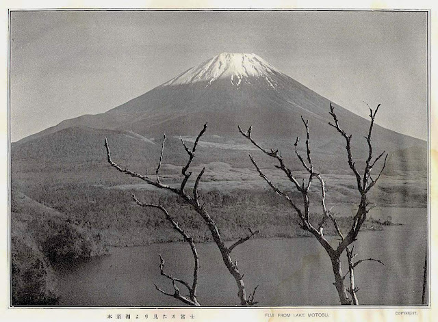
FUJIYAMA / 富士山 PHOTOGRAPHED BY HERBERT PONTING

HERBERT PONTING (1870-1935), FujiYama / 富士山 (3,776 m - 12,389 ft) Japan  In Fujisan from Lake Motosu, 1905 June-1st,  postcard, private collection

HERBERT PONTING (1870-1935),
FujiYama / 富士山 (3,776 m - 12,389 ft)
Japan

In Fuji from Lake Motosu, 1905 June-1st, postcard, private collection


The photographer
Herbert George Ponting, FRGS is best known as the expedition photographer and cinematographer for Robert Falcon Scott's Terra Nova Expedition to the Ross Sea and South Pole (1910–1913). In this role, he captured some of the most enduring images of the Heroic Age of Antarctic Exploration.
As a member of the shore party in early 1911, Ponting helped set up the Terra Nova Expedition's Antarctic winter camp at Cape Evans, Ross Island. The camp included a tiny photographic darkroom. Although the expedition came more than 20 years after the invention of photographic film, Ponting preferred high-quality images taken on glass plates.
Ponting was one of the first men to use a portable movie camera in Antarctica. The primitive device, called a cinematograph, could take short video sequences. Ponting also brought some autochrome plates to Antarctica and took some of the first known color still photographs there.
The catastrophic end of "Scott's Last Expedition" also affected Ponting's later life and career. When the Terra Nova had sailed south in 1910, it had left massive debts behind. It was expected that Scott would return from the South Pole as a celebrity and that he could use moving images from his expedition in a one-man show. Ponting's cinematograph sequences, pieced out with magic lantern slides, were to have been a key element in the expedition's financial payback.
In 2009, SPRI and publisher Salto Ulbeek platinum-printed and published a selection of the Collection. In addition, one of Ponting's photographic darkrooms was reconstructed in the collections of the Ferrymead Heritage Park in Christchurch, New Zealand.

The mountain
Mount Fuji or Fujiyama (富士山) is located on Honshu Island and is the highest mountain peak in Japan at 3,776.24 m (12,389 ft). Several names are attributed to it: "Fuji-san", "Fujiyama" or, redundantly, "Mt. Fujiyama". Usually Japanese speakers refer to the mountain as "Fuji-san". The other Japanese names for Mount Fuji, have become obsolete or poetic like: Fuji-no-Yama (ふじの山 - The Mountain of Fuji), Fuji-no-Takane (The High Peak of Fuji), Fuyō-hō (The Lotus Peak), and Fugaku , created by combining the first character of 富士, Fuji, and 岳, mountain.
Mount Fuji is an active stratovolcano that last erupted in 1707–08. Mount Fuji lies about 100 kilometres (60 mi) south-west of Tokyo, and can be seen from there on a clear day.
Mount Fuji's exceptionally symmetrical cone, which is snow-capped several months a year, is a well-known symbol of Japan and it is frequently depicted in art and photographs, as well as visited by sightseers and climbers.
Mount Fuji is one of Japan's Three Holy Mountains along with Mount Tate and Mount Haku. It is also a Special Place of Scenic Beauty and one of Japan's Historic Sites.
It was added to the World Heritage List as a Cultural Site on June 22, 2013. As per UNESCO, Mount Fuji has “inspired artists and poets and been the object of pilgrimage for centuries”. UNESCO recognizes 25 sites of cultural interest within the Mt. Fuji locality. These 25 locations include the mountain itself, Fujisan Hongū Sengen Shrine and six other Sengen shrines, two lodging houses, Lake Yamanaka, Lake Kawaguchi, the eight Oshino Hakkai hot springs, two lava tree molds, the remains of the Fuji-kō cult in the Hitoana cave, Shiraito Falls, and Miho no Matsubara pine tree grove; while on the low alps of Mount Fuji lies the Taisekiji temple complex, where the central base headquarters of Nichiren Shoshu Buddhism is located....

___________________________________________


2021 - Wandering Vertexes...
by Francis Rousseau

Wednesday, April 7, 2021

FUJIYAMA / 富士山 BY SHIRO KASAMATSU / 笠松 紫浪


SHIRO  KASAMATSU, 笠松 紫浪, biography,  FujiYama,  富士山,  Japan, Fuji from Yoshida Yamanashi, 1958,  Woodblock Print

SHIRO  KASAMATSU / 笠松 紫浪) (1898-1991)
FujiYama / 富士山 (3,776 m - 12,389 ft)
Japan


In Fuji from Yoshida Yamanashi, 1958,  Woodblock Print Ink and color on paper, Private collection

 
The artist
Shiro Kasamatsu (笠松 紫浪) was a Japanese engraver and print maker trained in the Shin-Hanga and Sōsaku-Hanga styles of woodblock printing. Kasamatsu was born in Tokyo in 1898 and apprenticed at the age of 13 to Kaburagi Kiyokata (1878-1973), a traditional master of Bijin-ga, pictures of beautiful women. Kasamatsu however took an interest in landscape and was given the pseudonym Shiro by his teacher, which he used as a signature mark in his prints.  Kasamatsu made woodblock prints for the publisher Shōzaburō Watanabe from 1919.  Almost all the woodblocks were destroyed in a fire in Watanabe's print shop following the Great Kanto Earthquake of 1923. Around 50 prints were published by Watanabe by the late 1940s. Kasamatsu began to partner with Unsodo in Kyoto from the 1950s and produced nearly 102 prints by 1960. He also began to print and publish on his own in the Sōsaku-Hanga style. He produced nearly 80 Sōsaku-Hanga prints between 1955 and 1965.


The mountain

Mount Fuji or Fujiyama (富士山) is located on Honshu Island and is the highest mountain peak in Japan at 3,776.24 m (12,389 ft). Several names are attributed to it: "Fuji-san", "Fujiyama" or, redundantly, "Mt. Fujiyama". Usually Japanese speakers refer to the mountain as "Fuji-san". The other Japanese names for Mount Fuji, have become obsolete or poetic like: Fuji-no-Yama (ふじの山 - The Mountain of Fuji), Fuji-no-Takane (The High Peak of Fuji), Fuyō-hō (The Lotus Peak), and Fugaku , created by combining the first character of 富士, Fuji, and 岳, mountain.
Mount Fuji is an active stratovolcano that last erupted in 1707–08. Mount Fuji lies about 100 kilometres (60 mi) south-west of Tokyo, and can be seen from there on a clear day.
Mount Fuji's exceptionally symmetrical cone, which is snow-capped several months a year, is a well-known symbol of Japan and it is frequently depicted in art and photographs, as well as visited by sightseers and climbers.
Mount Fuji is one of Japan's Three Holy Mountains along with Mount Tate and Mount Haku. It is also a Special Place of Scenic Beauty and one of Japan's Historic Sites.
It was added to the World Heritage List as a Cultural Site on June 22, 2013. As per UNESCO, Mount Fuji has “inspired artists and poets and been the object of pilgrimage for centuries”. UNESCO recognizes 25 sites of cultural interest within the Mt. Fuji locality. These 25 locations include the mountain itself, Fujisan Hongū Sengen Shrine and six other Sengen shrines, two lodging houses, Lake Yamanaka, Lake Kawaguchi, the eight Oshino Hakkai hot springs, two lava tree molds, the remains of the Fuji-kō cult in the Hitoana cave, Shiraito Falls, and Miho no Matsubara pine tree grove; while on the low alps of Mount Fuji lies the Taisekiji temple complex, where the central base headquarters of Nichiren Shoshu Buddhism is located....

___________________________________________
2021 - Wandering Vertexes...
by Francis Rousseau

Wednesday, March 31, 2021

PIZ ROSEG PAINTED BY JOHANNES SCHÜTZ

JOHANNES SCHÜTZ (1886-1953) ,Piz Roseg (3,937 m -12,917 ft) Switzerland - Italy, In Piz Roseg, Sellagruppe,Fuorcla-Surlej, Graubunden, Switzerland, Italy, John Mitchell Gallery


JOHANNES SCHÜTZ (1886-1953)
Piz Roseg (3,937 m -12,917 ft)
Switzerland - Italy border

In Piz Roseg and the Sellagruppe as seen from Fuorcla-Surlej, Graubunden, Switzerland. oil on canvas, 82 x 62cm, 1934, Courtesy John Mitchell Gallery


The mountain

Piz Roseg (3,937 m -12,917 ft)  is a mountain of the Bernina Range, overlooking the Val Roseg in the Swiss canton of Graubünden.There are two summits on its main ridge:
- the south-east and higher summit (3,937 m)
- the north-west summit, known as the Schneekuppe (3,920 m). There is also a prominent top on the east-north-east ridge, called the Roseg Pitschen (3,868 m) (Italian border).
The first ascent of the mountain to the Schneekuppe was by F. T. Bircham with guides Peter Jenny and Alexander Fleury on 31 August 1863. The highest point of the mountain was reached two years later by A. W. Moore and Horace Walker with guide Jakob Anderegg on 28 June 1865.
Piz Roseg is separated from the neighbouring Piz Scerscen by the Porta da Roseg (3,522 m), also called the Güssfeldtsattel. The Swiss side of this col – a steep ice slope of up to 70° – was first climbed by Paul Güssfeldt, with guides Hans Grass, Peter Jenny and Caspar Capat on 13 September 1872. Grass and Capat had spent the previous day cutting steps up the first two-fifths of the route. The following day they added at least another 450 steps on the first ascent.
The 700-metre north-east face of Piz Roseg was first climbed by Christian Klucker and L. Norman-Neruda on 16 July 1890; the face – with a notable serac band halfway up – sports a number of difficult routes. Klucker, together with M. Barberia, also made the first traverse from the Italian side of the Porta da Roseg on 21 June 1898.


The artist
Schütz is a academic Swiss painter, born in the Netherlands. He comes from a family of artists. He is reknown for having painted the Swiss and Italian Alps mountains. No biographical details are avalaible about him, even if his works appears quite often in auctions.


___________________________________________
2021- Wandering Vertexes...
by Francis Rousseau


Wednesday, February 17, 2021

MOUNT EREBUS BY EDWARD ADRIAN WILSON


https://wanderingvertexes.blogspot.com/2021/02/mount-erebus-by-edward-adrian-wilson.html

EDWARD ADRIAN WILSON (1872-1912)
Mount Erebus (3, 794 m - 12, 448ft)
Antarctica (Ross Island)


In Mount Erebus, 1906, watercolour, Royal Geographical Society Museum, London


The mountain
Mount Erebus (3, 794 m - 12, 448ft), not to be confused with Mount Elbrus is the second-highest volcano in Antarctica (after Mount Sidley) and the southernmost active volcano on Earth. It is the sixth highest ultra mountain on an island, located on Ross Island, which is also home to three inactive volcanoes: Mount Terror, Mount Bird, and Mount Terra Nova.
The volcano has been active since c. 1.3 million years ago and is the site of the Mount Erebus Volcano Observatory run by the New Mexico Institute of Mining and Technology.
Mount Erebus was discovered on January 27, 1841 (and observed to be in eruption) by polar explorer Sir James Clark Ross who named it and its companion, Mount Terror, after his ships, Erebus and Terror (which were later used by Sir John Franklin on his disastrous Arctic expedition). Erebus is a dark region in Hades in Greek mythology. Present with Ross on the Erebus was the young Joseph Hooker, future president of the Royal Society and close friend of Charles Darwin. Erebus was an Ancient Greek primordial deity of darkness, the son of Chaos.
Mount Erebus is classified as a polygenetic stratovolcano. The bottom half of the volcano is a shield and the top half is a stratocone. The composition of the current eruptive products of Erebus is anorthoclase-porphyritic tephritic phonolite and phonolite, which are the bulk of exposed lava flow on the volcano. Erebus is the world's only presently erupting phonolite volcano.
Researchers spent more than three months during the 2007–08 field season installing an unusually dense array of seismometers around Mount Erebus to listen to waves of energy generated by small, controlled blasts from explosives they buried along its flanks and perimeter and to record scattered seismic signals generated by lava lake eruptions and local ice quakes. By studying the refracted and scattered seismic waves, the scientists produced an image of the uppermost (top few km) of the volcano to understand the geometry of its "plumbing" and how the magma rises to the lava lake. These results demonstrated a complex upper-volcano conduit system with appreciable upper-volcano magma storage to the northwest of the lava lake at depths hundreds of meters below the surface.


The artist
Edward Adrian Wilson, nicknamed "Uncle Bill" was an English physician, polar explorer, natural historian, painter and ornithologist. Wilson took part in two British expeditions to Antarctica, the Discovery Expedition (1901-1904) and the tragic Terra Nova Expedition (1907-1912), both under the leadership of Scott.
Dr. Edward A. Wilson is widely regarded as one of the finest artists ever to have worked in the Antarctic. Sailing with Captain Scott aboard 'Discovery' (1901-1904), he became the last in a long tradition of 'exploration artists' from an age when pencil and water-colour were the main methods of producing accurate scientific records of new lands and animal species. He combined scientific, topographical and landscape techniques to produce accurate and beautiful images of the last unknown continent. Such was the strength of his work that it also helped to found the tradition of modern wildlife painting. In particular Wilson captured the essence of the flight and motion of Southern Ocean sea-birds on paper.
Returning with Captain Scott aboard 'Terra Nova' (1910-1913) as Chief of Scientific Staff, he continued to record the continent and its wildlife with extraordinary deftness. Chosen to accompany Captain Scott to the South Pole, his last drawings are from one of the most famous epic journeys in exploration history. Along with his scientific work, Wilson's pencil recorded the finding of Roald Amundsen's tent at the South Pole by Captain Scott. Wilson died, along with the other members of the British Pole Party, during the return journey, in March 1912. The drawings and paintings were created at considerable personal cost in the freezing conditions in which Wilson worked. He often suffered severely from the cold whilst sketching and also from snow-blindness, or sunburn of the eye. They provide a remarkable testament to one of the great figures of the heroic age of Antarctic exploration. The book has been produced as a companion volume to 'Edward Wilson's Nature Notebooks' by two of Wilson's great nephews, to mark the centenary of his death.


_______________________________
2021 - Wandering Vertexes..
Un blog de Francis Rousseau

Wednesday, February 3, 2021

FUJIYAMA / 富士山 (n°13) BY KATSUSHIKA HOKUSAÏ


KATSUSHIKA HOKUSAÏ (1760-1849)
Fujiyama / 富士山 (3,776.24 m -12,389 ft)
Japan

In Fujiyama from the Village of Sekiya at Sumida river,
n °13 from the series 36 Views of Mt. Fuji, 1830-32,
Edo Tokyo Museum, Japan


About the 36 Views of Mt Fuji

Thirty-six Views of Mount Fuji (富嶽三十六景 Fugaku Sanjūrokkei) is a series of landscape prints created by the Japanese ukiyo-e artist Hokusai (1760?1849). The series depicts Mount Fuji from different locations and in various seasons and weather conditions. The original thirty-six prints were so popular that Hokusai expanded the series by ten.
The earliest impressions appear faded when compared to the versions usually seen, but are closer to Hokusai's original conception. The original prints have a deliberately uneven blue sky, which increases the sky's brightness and gives movement to the clouds. The peak is brought forward with a halo of Prussian blue. Subsequent prints have a strong, even blue tone and the printer added a new block, overprinting the white clouds on the horizon with light blue. Later prints also typically employ a strong benigara (Bengal red) pigment, which lent the painting its common name of Red Fuji. The green block colour was recut, lowering the meeting point between forest and mountain slope.

The artist
Katsushika Hokusai (葛飾 北斎) was a Japanese artist, ukiyo-e painter and printmaker of the Edo period. He was influenced by such painters as Sesshu, and other styles of Chinese painting. Born in Edo (now Tokyo), Hokusai is best known as author of the woodblock print series Thirty-six Views of Mount Fuji (富嶽三十六景 c. 1831) which includes the internationally recognized print, The Great Wave off Kanagawa, created during the 1820s.
Hokusai created the "Thirty-Six Views of Mt Fuji " both as a response to a domestic travel boom and as part of a personal obsession with Mount Fuji. In this series, Mt Fuji is painted on different meteorological conditions, in different hours of the days, in different seasons and from different places.

The mountain
This is the legendary Mount Fuji or Fujiyama (富士山).
It is located on Honshu Island and is the highest mountain peak in Japan at 3,776.24 m (12,389 ft). Several names are attributed to it: "Fuji-san", "Fujiyama" or, redundantly, "Mt. Fujiyama". Usually Japanese speakers refer to the mountain as "Fuji-san". The other Japanese names for Mount Fuji, have become obsolete or poetic like: Fuji-no-Yama (ふじの山 - The Mountain of Fuji), Fuji-no-Takane (ふじの高嶺- The High Peak of Fuji), Fuyō-hō (芙蓉峰 - The Lotus Peak), and Fugaku (富岳/富嶽), created by combining the first character of 富士, Fuji, and 岳, mountain.
Mount Fuji is an active stratovolcano that last erupted in 1707–08. Mount Fuji lies about 100 kilometres (60 mi) south-west of Tokyo, and can be seen from there on a clear day.
Mount Fuji's exceptionally symmetrical cone, which is snow-capped several months a year, is a well-known symbol of Japan and it is frequently depicted in art and photographs, as well as visited by sightseers and climbers.
Mount Fuji is one of Japan's Three Holy Mountains (三霊山) along with Mount Tate and Mount Haku. It is also a Special Place of Scenic Beauty and one of Japan's Historic Sites.
It was added to the World Heritage List as a Cultural Site on June 22, 2013. As per UNESCO, Mount Fuji has “inspired artists and poets and been the object of pilgrimage for centuries”. UNESCO recognizes 25 sites of cultural interest within the Mt. Fuji locality. These 25 locations include the mountain itself, Fujisan Hongū Sengen Shrine and six other Sengen shrines, two lodging houses, Lake Yamanaka, Lake Kawaguchi, the eight Oshino Hakkai hot springs, two lava tree molds, the remains of the Fuji-kō cult in the Hitoana cave, Shiraito Falls, and Miho no Matsubara pine tree grove; while on the low alps of Mount Fuji lies the Taisekiji temple complex, where the central base headquarters of Nichiren Shoshu Buddhism is located.


______________________________

2021 - Wandering Vertexes...
by Francis Rousseau


Saturday, December 12, 2020

LA DENT DU GÉANT PAINTED BY MARCEL WIBAULT


https://wanderingvertexes.blogspot.com/2020/12/la-dent-du-geant-painted-by-marcel.html


MARCEL WIBAULT (1904-1998)
La dent du Géant (4,013 m -13,166 ft)
France - Italy


The mountain
The Dent du Géant (4,013 m -13,166 ft) (« Giant's tooth") is a mountain in the Mont Blanc massif in France and Italy. The Dent du Géant remained unclimbed during the golden age of alpinism, and was a much-coveted peak in the 1870s, repelling many parties who attempted it mostly from the Rochefort ridge. In 1880 the strong team of Albert F. Mummery and Alexander Burgener tried to force a passage via the south-west face but were repelled by a band of slabs, causing Mummery to exclaim 'Absolutely inaccessible by fair means!'
The mountain has two summits, (27m-88 ft) apart and separated by a small col :
- Pointe Sella (4,009 m), first ascent via the south-west face by Jean Joseph Maquignaz with son Baptiste Maquignaz and nephew, Daniel Maquignaz on 28 July 1882.
- Pointe Graham (4,013 m), first ascent by W. W. Graham with guides Auguste Cupelin and Alphonse Payot on 20 August 1882.


The artist
Marcel Wibault is a french painter known especially for his numerous paintings of mountains representing Mont-Blanc, Chamonix, the great peaks of the Alps and their "chalets". He made his débuts in art by ketching soldiers of the 60th Infantry Regiment of Besançon. Later he discovered, as a Member of the French Alpine Club, the Alps and its grandiose landscapes. At the start of the 1930s, he settled in Chamonix-Mont-Blanc and discovered, in these troubled times, the departments of Savoie and Haute-Savoie. Encouraged by his wife, Marcel Wibault painted the mountain and its surroundings. Living in Chamonix, he travels the surroundings with his painting equipment. He could produce works in one sitting. Commissioned by the Museum of Natural History and the city of Geneva in Switzerland, as a true knowledgeable geologist, he painted numerous rocks. In the 1960s, he also testified, through his painting, of the construction of the Mont-Blanc Tunnel. Marcel Wibault received many commissions from art lovers and was able to live in part from his art. He was also a teacher for his son Lionel Wibault who, too, is a painter. In his Chamonix chalet, Alpenrose, he made some of his furniture and sculpted many characters. 


Tuesday, November 17, 2020

THE WETTERHORN PAINTED BY ALEXANDRE CALAME

https://wanderingvertexes.blogspot.com/2020/11/the-wetterhorn-painted-by-alexandre.html


ALEXANDRE CALAME (1810-1864)
The Wetterhorn (3,692m-12,113ft)
Switzerland

In "In het Berner Oberland" (1847) Oil on canvas, 78 x 100 cm , Amsterdam Museum


The Mountain
The Wetterhorn (3,692m-12,113ft) in the Bernese Alps, towers above the village of Grindelwald. Formerly known as Hasle Jungfrau, it is one of three summits of a mountain named Wetterhorn sensu lato, or the "Wetterhцrner", the highest summit of which is the Mittelhorn (3,704 m) and the most distant the Rosenhorn (3,689 m). The Mittelhorn and Rosenhorn are mostly hidden from view from Grindelwald. The Grosse Scheidegg Pass crosses the col to the north, between the Wetterhorn and the Schwarzhorn.
Climbing
The Wetterhorn summit was first reached on August 31, 1844, by the Grindelwald guides Hans Jaun and Melchior Bannholzer, three days after they had co-guided a large party organized by the geologist Edouard Desor to the first ascent of the Rosenhorn. The Mittelhorn was first summitted on 9 July 1845 by the same guides, this time accompanied by a third guide, Kaspar Abplanalp, and by Stanhope Templeman Speer. The son of a Scottish physician, Speer lived in Interlaken, Switzerland.
A September 1854 ascent by a party including Alfred Wills is much celebrated in Great Britain. Apparently believing to be the first ascendant, Wills' description of this trip in his book "Wanderings Among the High Alps" (published in 1856) helped make mountaineering fashionable in Britain and ushered in the systematic exploration of the Alps by British mountaineers, the so-called golden age of alpinism.  Despite several well-documented earlier ascents and the fact that he was guided to the top, even in his obituary in 1912 he was considered to be "certainly the first who can be said with any confidence to have stood upon the real highest peak of the Wetterhorn proper" (i.e. the 3,692 m summit).  In a subsequent corrigendum, the editors admitted two earlier ascents, but considered his still "the first completely successful" one.
In 1866, Lucy Walker was the first documented female ascendant of the peak.
The 24-year-old English mountaineer William Penhall and his Meiringen guide Andreas Maurer were killed by an avalanche high up on the Wetterhorn on 3 August 1882.
The famed guide and Grindelwald native Christian Almer climbed the mountain many times in his life, including on his first of many trips with Meta Brevoort and her nephew W. A. B. Coolidge in 1868. His last ascent was in 1898 at the age of 70 together with his wife to celebrate their golden anniversary on top.  Winston Churchill is also supposed  to have climbed the Wetterhorn in 1894.

The painter
Alexandre Calame was a Swiss painter. He was the son of a skillful marble worker in Vevey. His father lost the family fortune, and Alexandre Calame was forced to work in a bank at the age of 15. When his father fell from a building and then died, the young Calame provided for his mother.
In his spare time he began to practice drawing small views of Switzerland. In 1829 he met his patron, the banker Diodati, who made it possible for him to study under landscape painter François Diday. After a few months he decided to devote himself fully to art.
In 1835, he began exhibiting his Swiss-Alps and forest paintings in Paris and Berlin. He became quite well known, especially in Germany, although Calame was more a drawer than an illustrator. He is associated with the Dusseldorf school of painting. In 1842 he went to Paris and displayed his works Mont Blanc, the Jungfrau, the Brienzersee, the Monte Rosa and Mont Cervin. He taught in Geneva, where Adolf Mosengel was one of his pupils.
He went to Italy in 1844 and brought back from Rome and Naples countless paintings, among them one of the ruins of Paestum (in the city museum in Leipzig). He showed that he was capable of understanding Italian nature; but the Alps remained his speciality.
The glaciers, emerald-green, white foaming mountain water, which split the trees during the storm, and the whipped clouds, the multi-colored rocks, half masked from fog, in the rays of the gleaming sun, are those things, which he knew to be true to nature.
One of his most ingenious works is the representation of the four seasons and times of the day in four landscapes, a spring morning in the south, a summer midday in the Nordic flatlands, an Autumn evening, and a winter night on a mountain. He became popular with these large works, and his popularity grew with smaller pieces and lithographies, namely 18 studies of Lauterbrunnen and Meiringen and the 24 sheets of Alpine passes. These were widespread in France, England, and Germany and are still today used to teach this style of painting.
He died in Menton, France in 1864. An exhibition featuring more than thirty of Calame's paintings was held at the Sterling and Francine Clark Art Institute in Williamstown, Massachusetts in 2006.

______________________________
2020 - Wandering Vertexes...
by Francis Rousseau