google.com, pub-0288379932320714, DIRECT, f08c47fec0942fa0 GRAVIR LES MONTAGNES... EN PEINTURE: - AFRICA
Showing posts with label - AFRICA. Show all posts

Monday, February 28, 2022

SWARTBERG MOUNTAINS SKETCHED BY DOUGLAS TREASURE


DOUGLAS TREASURE (1917-1995) The Swartberg mountains (2,325 m - 7,628 ft) South Africa (Western Cape)   In Huis Rivier Near Calitzdorp, Cape, watercolour


DOUGLAS TREASURE (1917-1995)
The Swartberg mountains (2,325 m - 7,628 ft)
South Africa (Western Cape)

 In Huis Rivier Near Calitzdorp, Cape, watercolour 


The mountains
The Swartberg mountains (2,325 m - 7,628 ft) (black mountain in Afrikaans) are a mountain range in the Western Cape province of South Africa. It is composed of two main mountain chains running roughly east–west along the northern edge of the semi-arid Little Karoo. To the north of the range lies the other large semi-arid area in South Africa, the Great Karoo. Most of the Swartberg Mountains are above 2000 m high, making them the tallest mountains in the Western Cape. It is also one of the longest, spanning some 230 km from south of Laingsburg in the west to between Willowmore and Uniondale in the east. Geologically, these mountains are part of the Cape Fold Belt. Much of the Swartberg is part of a UNESCO World Heritage Site.

The painter
Douglas Treasure obtained his formal training at the Port Elisabeth School of Art. A commercial art career included extensive experience as a illustrator, designer, visualiser and finally art director of a major company. During this time his love of watercolour landscape painting flourished, and in 1973 he retired from advertising in order to become a full-time professional painter. Douglas Treasure is the only South African represented in best selling British Author Ron Ransom's new book, Watercolour Impressionists. His works are represented in private collections in England, America, Italy, Switzerland, Germany, Australia and Argentina.

_______________________________

2022 - Wandering Vertexes...
by Francis Rousseau

Thursday, January 20, 2022

CATHEDRAL PEAK PAINTED BY JACOBUS HENDRIK PIERNEEF


JACOBUS HENDRIK PIERNEEF (1886-1957)
Cathedral Peak (3,004 m - 9,856 ft)
South Africa (Natal)

The mountain
Cathedral Peak is a mountain in KwaZulu-Natal, South Africa. It is a 3,004 m (9,856 ft) high free standing mountain in the Drakensberg. The mountain is also known as Mponjwana (Little Horn) by the local Amangwanepeople. Cathedral Peak is part of the Cathedral Ridge which is at right angles to the main range. Other peaks in the spur are the Twins, also known as the Triplets, (2,899 m or 9,510 feet), the Bell (2,930 m or 9,800 feet), the Outer (3,006 m or 9,860 feet) and Inner (3,005 m or 9,858 feet) Horns, the Chessmen (2,987 m or 9,800 feet) and Mitre Peak (3,023 m or 9,919 feet).
Cathedral Peak was first climbed by D.W. Basset-Smith and R.G. Kingdon in 1917, via the gully.


The painter
Jacobus Hendrik (Henk) Pierneef (usually referred to as Pierneef) was a South African landscape artist, generally considered to be one of the best of the old South African masters. His distinctive style is widely recognized and his work was greatly influenced by the South African landscape.
Most of his landscapes were of the South African highveld, which provided a lifelong source of inspiration for him. Pierneef's style was to reduce and simplify the landscape to geometric structures, using flat planes, lines and colour to present the harmony and order in nature. This resulted in formalised, ordered and often-monumental view of the South African landscape, uninhabited and with dramatic light and colour.
Pierneef's work can be seen worldwide in many private, corporate and public collections, including the Africana Museum, Durban Art Gallery, Johannesburg Art Gallery, King George VI Art Gallery, Pierneef Museum and the Pretoria Art Gallery.

___________________________

2022 - Wandering Vertexes...
by Francis Rousseau

Saturday, December 25, 2021

MOUNT SINAÏ/ JABAL MUSA IMAGINED BY FRA ANGELICO


FRA ANGELICO (1395-1455) Mount Sinaï / Jabal Musa (2,285 m - 7,496ft) Egypt  In Fuga in egitto, 1450, toile 38,5x37cm, Museo di San Marco, Firenze,


FRA ANGELICO (1395-1455)
Mount Sinaï / Jabal Musa (2,285 m - 7,496ft)
Egypt

In Fuga in egitto, 1450, toile 38,5x37cm, Museo di San Marco, Firenze, 


The painter
Fra Angelico (born Guido di Pietro) was an Italian painter of the Early Renaissance, described by Vasari in his Lives of the Artists as having "a rare and perfect talent".  He earned his reputation primarily for the series of frescoes he made for his own friary, San Marco, in Florence. He was known to contemporaries as Fra Giovanni da Fiesole (Brother John of Fiesole) and Fra Giovanni Angelico (Angelic Brother John). In modern Italian he is called Beato Angelico (Blessed Angelic One);  the common English name Fra Angelico means the "Angelic friar".
In 1982, Pope John Paul II proclaimed his beatification in recognition of the holiness of his life, thereby making the title of "Blessed" official.  Fiesole is sometimes misinterpreted as being part of his formal name, but it was merely the name of the town where he took his vows as a Dominican friar,  and was used by contemporaries to separate him from others who were also known as Fra Giovanni. He is listed in the Roman Martyrology as Beatus Ioannes Faesulanus, cognomento Angelicus—"Blessed Giovanni of Fiesole, surnamed 'the Angelic' ".
Vasari wrote of Fra Angelico that "it is impossible to bestow too much praise on this holy father, who was so humble and modest in all that he did and said and whose pictures were painted with such facility and piety."
 
The mountain 
Mount Sinaï (2,285 m - 7,496ft) or Jabal Mūsā or Gabal Mūsā (in arab  : "Moses' Mountain" or "Mount Moses"), also known as Mount Horeb or Jebel Musa (a similarly named mountain in Morocco), is a mountain in the Sinai Peninsula of Egypt that is a possible location of the biblical Mount Sinaï. 
The latter is mentioned many times in the Book of Exodus (and other books of the Bible) and in the Quran. According to Jewish, Christian, and Islamic tradition, the biblical Mount Sinai was the place where Moses received the Ten Commandments (depicted in the Jean-Léon Gérôme painting above).
Mount Sinai is a moderately high mountain near the city of Saint Katherine in the Sinai region. It is next to Mount Katherine (2,629m - 8,625 ft), the highest peak in Egypt. 
Mount Sinai's rocks were formed in the late stage of the Arabian-Nubian Shield's (ANS) evolution. Mount Sinai displays a ring complex that consists of alkaline granites intruded into diverse rock types, including volcanics. The granites range in composition from syenogranite to alkali feldspar granite. The volcanic rocks are alkaline to peralkaline and they are represented by subaerial flows and eruptions and subvolcanic porphyry. Generally, the nature of the exposed rocks in Mount Sinai indicates that they originated from differing depths.
There are two principal routes to the summit. The longer and shallower route, Siket El Bashait, takes about 2.5 hours on foot, though camels can be used. The steeper, more direct route (Siket Sayidna Musa) is up the 3,750 "steps of penitence" in the ravine behind the monastery.
The summit of the mountain has a mosque that is still used by Muslims. It also has a Greek Orthodox chapel, constructed in 1934 on the ruins of a 16th-century church, that is not open to the public. The chapel encloses the rock which is considered to be the source for the biblical Tablets of Stone. At the summit also is "Moses' cave", where Moses was said to have waited to receive the Ten Commandments.
___________________________________________

2021 - Wandering Vertexes...
by Francis Rousseau

Thursday, December 16, 2021

DJEBEL AÏSSA BY FREDERIC GADMER / AUTOCHROME LUMIÈRE


FREDERIC GADMER (1878-1954) Djebel Aïssa  (2,236 m  -7,336 ft) Algeria  In Djebel Aïssa, Aïn Sefra, Algérie; Autochrome de Frédéric Gadmer,  1929,

FREDERIC GADMER (1878-1954)
Djebel Aïssa  (2,236 m  -7,336 ft)
Algeria

In Djebel Aïssa, Aïn Sefra, Algérie; Autochrome de Frédéric Gadmer,  1929

The mountain
Mount Issa or Djebel Aïssa (جبل عيسى‎) is a mountain in western Algeria, thus the 4th highest in Algeria. It is part of the Ksour Range of the Saharan Atlas, within the larger Atlas Mountain System. Mount Issa is located in the Naâma Province and is one of the main summits of the mountains of the Saharan Atlas. The Djebel Aissa National Park is a protected area within the area of the mountain since 2003.

The photographer
Frédéric Georges Gadmer was born in 1878 in France into a Protestant family; his father, Leon, son of Swiss émigré, was confectioner. Before World War II, he follows his family in Paris and works as a photographer for the house Vitry, located Quai de la Rapée. As an heliogravure company, it performs work for the sciences and the arts, travel and education. In 1898 Gadmer completed his military service as a secretary to the staff then recalled in 1914 at the time of mobilization. In 1915, he joined the newly created  "Photographic Section of the Army" and carried pictures on the front, in the Dardanelles, with General Gouraud, then in Cameroon. In 1919, at age 41, he was hired as a photographer by Albert Khan for his project called "Archives of the Planet". He finds there his comrades of  "the film and photographic section of the army" Paul Castelnau and Fernand Cuville. Soon as he arrived, he made reports in Syria, Lebanon, Turkey and Palestine. It was the first to make a color portrait of Mustafa Kemal, leader of the Young Turks. In 1921, he returned to the Levant with Jean Brunhes, the scientific director of the Archives of the Planet. The same year, he attended General Gouraud, appointed High Commissioner in Syria. Operator and prolific photographer, specializing in distant lands and landscapes, it covers Iraq, Persia, Afghanistan, Algeria and Tunisia. In 1930, he accompanied Father Francis Aupiais in Dahomey. He also works in Europe. In 1931, at the request of Marechal Lyautey, he photographies the Colonial Exhibition. It is one of the last person to leave the "Archives of the Planet" threatened by the Albert Kahn's bankruptcy in 1932. He then worked at the famous french newspaper L'Illustration and carries postcards for Yvon. He died in Paris, unmarried, in 1954.

About the  "Autochrome Lumière" Photos
The autochrome is a photographic reproduction of process colors patented December 17, 1903 by Auguste and Louis Lumière french brothers. This is the first industrial technique of photography colors, it produces positive images on glass plates. It was used between 1907 and 1932 approximately an particularly in many pictures of the World War I. A important number of photographs of mountains and landscapes around the world was made with this technique, particularly in the for  the Project "The archives of the planet" by Albert Kahn.
_______________________________

2021 - Wandering Vertexes...
by Francis Rousseau

Tuesday, December 7, 2021

DJEBEL BOUKORNINE (2) PAINTED BY ALBERT MARQUET


ALBERT MARQUET (1875–1947) Jebel Boukornine (546 m -1791 ft) Tunisia  In Sidi Bou Saïd-palmier, oil on canvas, private collection

ALBERT MARQUET (1875–1947)
DJebel Boukornine (546 m -1791 ft)
Tunisia

In Sidi Bou Saïd-palmier, oil on canvas, private collection


The mountain
DJebel Boukornine (جبل بوقرنين‎), also spelled Jebel Bou Kornine or Mount Bou Kornine, is a 576-meter mountain in northern Tunisia, overlooking the Gulf of Tunis and Hammam Lif city.
It consists of folded and faulted outcrops of Jurassic limestone. Its name "bou kornine" comes from Tunisian Arabic meaning "the one with two horns", originally from the punic language as "ba'al kornine", meaning "lord with two horns". It owes its name to the two highlights of altitude 576 and 493 meters at the top. During the times of ancient Carthage, the mountain was considered sacred and religious rituals were conducted there.
The massif is part of Boukornine National Park, covering area of 1939 ha and protecting many species of plants and animals. The mountain slopes are covered Aleppo pine and cedar. Djebel Ressas about 30 km to the southwest is a taller peak at 795 m.

The painter
Albert Marquet  was a French painter, associated with the Fauvist movement. He initially became one of the Fauve painters and a lifelong friend of Henri Matisse. In 1890 Marquet moved to Paris to attend the Ecole des Arts Décoratifs, where he met Henri Matisse. They were roommates for a time, and they influenced each other's work. Marquet began studies in 1892 at the École des Beaux-Arts de Paris under Gustave Moreau, the famous symbolist artist. In 1905 he exhibited at the Salon d'Automne. Dismayed by the intense coloration in these paintings, critics reacted by naming the artists the "Fauves", i.e. the wild beasts. Although Marquet painted with the fauves for years, he used less bright and violent colours than the others, and emphasized less intense tones made by mixing complementaries, thus always as colors and never as grays.
From 1907 to his death, Marquet alternated between working in his studio in Paris (a city he painted a lot of times) and many parts of the European coast and in North Africa. He was most involved with Algeria and Algiers and Tunisia. He remained also impressed particularly with Naples and Venice where he painted the sea and boats, accenting the light over water. During his voyages to Germany and Sweden he painted the subjects he usually preferred: river and sea views, ports and ships, but also cityscapes.
Matisse said : "When I look at Hokusai, I think of Marquet—and vice versa ... I don't mean imitation of Hokusai, I mean similarity with him". 


__________________________________
2021 - Wandering Vertexes...
by Francis Rousseau

Wednesday, November 10, 2021

MOUNT SINAÏ -JABAL MUSA PAINTED BY GIOTTO

GIOTTO (1266-1337) Mount Sinaï or Jabal Musa (2,285 m - 7,496ft) Egypt  In The flight into Egypt, fresco, Basilica inferiore di Assisi, 1308-1

GIOTTO (1266-1337)
Mount Sinaï or Jabal Musa (2,285 m - 7,496ft)
Egypt

In The flight into Egypt, fresco, Basilica inferiore di Assisi, 1308-10


About this work
The right transept of the Lower Basilica of Assisi has numerous frescoes by important fourteenth-century authors. On the large barrel vault there are the Stories of Christ's Childhood and the Crucifixion with Franciscan Saints by Giotto and collaborators, dated 1308-1311. The image depicts the scene of the Flight into Egypt already apunted by Giotto few years before in the interior frescoes of the Scrovegni Chapel in Padua, also known as the Arena Chapel. Inetrestirng to have a look at the differencies.

The mountain
Mount Sinaï (2,285 m - 7,496ft) or Jabal Mūsā or Gabal Mūsā (in arab : "Moses' Mountain" or "Mount Moses"), also known as Mount Horeb or Jebel Musa (a similarly named mountain in Morocco), is a mountain in the Sinai Peninsula of Egypt that is a possible location of the biblical Mount Sinaï.
The latter is mentioned many times in the Book of Exodus (and other books of the Bible) and in the Quran. According to Jewish, Christian, and Islamic tradition, the biblical Mount Sinai was the place where Moses received the Ten Commandments (depicted in the Jean-Léon Gérôme painting above).
Mount Sinai is a moderately high mountain near the city of Saint Katherine in the Sinai region. It is next to Mount Katherine (2,629m - 8,625 ft), the highest peak in Egypt.
Mount Sinai's rocks were formed in the late stage of the Arabian-Nubian Shield's (ANS) evolution. Mount Sinai displays a ring complex that consists of alkaline granites intruded into diverse rock types, including volcanics. The granites range in composition from syenogranite to alkali feldspar granite. The volcanic rocks are alkaline to peralkaline and they are represented by subaerial flows and eruptions and subvolcanic porphyry. Generally, the nature of the exposed rocks in Mount Sinai indicates that they originated from differing depths.
There are two principal routes to the summit. The longer and shallower route, Siket El Bashait, takes about 2.5 hours on foot, though camels can be used. The steeper, more direct route (Siket Sayidna Musa) is up the 3,750 "steps of penitence" in the ravine behind the monastery.
The summit of the mountain has a mosque that is still used by Muslims. It also has a Greek Orthodox chapel, constructed in 1934 on the ruins of a 16th-century church, that is not open to the public. The chapel encloses the rock which is considered to be the source for the biblical Tablets of Stone. At the summit also is "Moses' cave", where Moses was said to have waited to receive the Ten Commandments.

The painter
Giotto di Bondone known mononymously as Giotto was an Italian painter and architect from Florence during the Late Middle Ages. He worked during the "Gothic or Proto-Renaissance" period.
Giotto's contemporary, the banker and chronicler Giovanni Villani, wrote that Giotto was "the most sovereign master of painting in his time, who drew all his figures and their postures according to nature" and of his publicly recognized "talent and excellence".
In his Lives of the Most Excellent Painters, Sculptors, and Architects, Giorgio Vasari described Giotto as making a decisive break with the prevalent Byzantine style and as initiating "the great art of painting as we know it today, introducing the technique of drawing accurately from life, which had been neglected for more than two hundred years".
That Giotto painted the Arena Chapel and that he was chosen by the Commune of Florence in 1334 to design the new campanile (bell tower) of the Florence Cathedral are among the few certainties about his life. Almost every other aspect of it is subject to controversy: his birth date, his birth place, his appearance, his apprenticeship, the order in which he created his works, whether or not he painted the famous frescoes in the Upper Basilica of Saint Francis in Assisi and his burial place.

_______________________________

2021 - Wandering Vertexes...
by Francis Rousseau

Wednesday, September 8, 2021

MOUNT KILIMANDJARO PAINTED BY PILLY TURNER

PILLY TURNER (active 1955-1970)
 Kilimandjaro (5,885m - 19,340ft)n 
Tanzania,  In Kilimandjaro from Tanzania's Lake Chala, oil on canvas, 1961, Private Collection

PILLY TURNER (active 1955-1970)

Kilimandjaro (5,885m - 19,340ft)

Tanzania

In Kilimandjaro from Tanzania's Lake Chala, oil on canvas, 1961, Private Collection 


The mountain

Mount Kilimanjaro (5,885m - 19, 340ft) is a dormant volcano in Tanzania composed of three volcanic cones, "Kibo", "Mawenzi", and "Shira. The Kilimandjaro is the highest mountain in Africa. The first recorded ascent to the summit was by Hans Meyer and Ludwig Purtscheller in 1889.
The mountain is part of the Kilimanjaro National Park and is a major climbing destination. The mountain has been the subject of many scientific studies because of its shrinking glaciers, especially since 200.
The origin of the name "Kilimanjaro" is not precisely known, but a number of theories exist. European explorers had adopted the name by 1860 and reported that "Kilimanjaro" was the mountain's Kiswahili name. The 1907 edition of The Nuttall Encyclopædia also records the name of the mountain as "Kilima-Njaro", as well as the title of the watercolor above. Johann Ludwig Krapf wrote in 1860 that Swahilis along the coast called the mountain Kilimanjaro. Although he did not support his claim, he claimed that "Kilimanjaro" meant either "mountain of greatness" or "mountain of caravans". Under the latter meaning, "Kilima" meant "mountain" and "Jaro" possibly meant "caravans". Jim Thompson claimed in 1885, although he also did not support his claim, that the term Kilima-Njaro "has generally been understood to mean" the Mountain (Kilima) of Greatness (Njaro). Though not improbably it may mean the "White" mountain. "Njaro" is an ancient Kiswahili word for "shining". Others have assumed that "Kilima" is Kiswahili for "mountain".
In the 1880s, the mountain became a part of German East Africa and was called "Kilima-Ndscharo" in German following the Kiswahili name components.
On 6 October 1889, Hans Meyer reached the highest summit on the crater ridge of Kibo. He named it "Kaiser-Wilhelm-Spitze" ("Kaiser Wilhelm peak").
That name apparently was used until Tanzania was formed in 1964, when the summit was renamed "Uhuru", meaning "Freedom Peak" in Kiswahili.The mountain Mount Kilimanjaro (5,885m - 19, 340ft) is a dormant volcano in Tanzania composed of three volcanic cones, "Kibo", "Mawenzi", and "Shira. The Kilimandjaro is the highest mountain in Africa. The first recorded ascent to the summit was by Hans Meyer and Ludwig Purtscheller in 1889.
The mountain is part of the Kilimanjaro National Park and is a major climbing destination. The mountain has been the subject of many scientific studies because of its shrinking glaciers, especially since 2000....


The artist

Pilly Turner is a kenyan watercolourist, active during the 1955-1970 's. The watercolor she painted are always very realistic, and with exemples of wild life animals and animals of the country. There are no other information available about this artist and only a few amount of paintings on the art market (more than 10).


___________________________________________


2021 - Wandering Vertexes...

by Francis Rousseau 


Saturday, June 5, 2021

ADRAR SAGRO PAINTED BY PAUL-JEAN FLANDRIN

PAUL-JEAN FLANDRIN (1811-1902) Adrar Sagro  (2,712m - 8,897ft) Morocco    In   "Les Gorges de l'Atlas, " 1843, oil on canvas, 1843, Private collection


PAUL-JEAN FLANDRIN (1811-1902)
Adrar Sagro  (2,712m - 8,897ft)
Morocco 

 In   "Les Gorges de l'Atlas, " 1843, oil on canvas, 1843, Private collection


The mountain
Adrar Saghro or Jebel Saghro (2,712m - 8,897ft) is a mountain in southern Morocco, located east of Ouarzazate, 70 km south of the central High Atlas, dominating the Drâa valleys to the west and south, and that of Dades to the north. It constitutes the eastern part of the Anti-Atlas. Jebel Saghro is the driest area of the Anti-Atlas range. Unlike the areas located further west, it does not benefit from a high enough air humidity due to the remoteness of the Atlantic Ocean. Annual precipitation does not exceed 100 mm in the south and 300 mm on the summits. Jebel Saghro is oriented along a southwest / northeast axis, and extends towards Jebel Ougnat east of Wadi Alnif and the Tizi n'Boujou pass. It borders the Dades valley and the High Atlas to the north and links the Drâa valley to the south. Lunar landscape of plateaus, peaks, canyons crossed by wadis, forests, all dominated by basalt peaks. Oleanders, junipers, mountain flowers ... occupy the valley bottoms. The north-south crossings are made by three passes crossed by difficult and very spectacular tracks: the Tazazert pass (2,283 m), the Kouaouch pass (2,592 m), and the Tagmout pass (1,919 m). The highest point of the mountain is Amalou n Mansour (2,712 m) which is located to the south-east of the village of Iknioun.
Charles de Foucauld, still only in search of adventure, is one of the first Western travelers to have described his crossing of Jebel Saghro (Reconnaissance au Maroc published in 1888 in Paris). It completes its description with a topographic survey. Jebel Saghro was also later the setting for fierce fighting linked to the progression of the French army within the framework of the protectorate, the battle of Bougafer (February-March 1933), in which the French troops allied to those of the Sultan of Morocco faced an impressive and heroic resistance from the Aït Atta tribes led by Sheikh Assou Oubasslam. It is in this massif that the famous captain Henry de Bournazel, one of the protagonists of this war, was killed in the fight against the Berbers, while assaulting the rocky dome.

 
The painter
Paul-Jean Flandrin is a French painter, younger brother of the painters Auguste Flandrin and Hippolyte Flandrin. he first received advice from the landscape and animal painter Antoine Duclaux, as well as from the sculptor Jean-François Legendre-Héral, before joining the École des beaux-arts de Lyon, then that of Paris and the workshop by Jean-Auguste-Dominique Ingres.
He failed twice in the Prix de Rome competition but nevertheless joined at his own expense his brother Hippolyte in Italy. They stayed in Rome for four years, during which Paul specialized in landscape painting. He carried out studies from nature which he used to undertake historical compositions which he presented at the Parisian Salons. He also regularly collaborates on the landscapes of his older brother's paintings. Flandrin continued until late in the nineteenth century this tradition of classical landscape of which he was one of the best representatives, alongside Édouard Bertin or his father-in-law Alexandre Desgoffe. He combines this with a sense of line and ideal inherited from the lessons of his master Ingres. Charles Baudelaire thus accuses him of wanting to “Ingriser” (painted like Ingres) the landscape, a criticism that will long be associated with it. 

______________________

2021 - Wandering Vertexes...
by Francis Rousseau

Wednesday, April 28, 2021

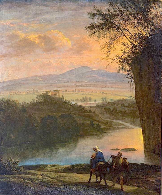
MOUNT SINAI / JABAL MUSA PAINTED BY JAN ASSELIJN

Jan Asselijn (c.1610 – October 1, 1652) Mount Sinaï / Jabal Musa (2,285 m - 7,496ft) Egypt In Flight into Egypt, c. 1640, oil on canvas, Rijksmuseum, Amsterdam


Jan Asselijn (c.1610 – October 1, 1652)
Mount Sinaï / Jabal Musa (2,285 m - 7,496ft)
Egypt

In Flight into Egypt, c. 1640, oil on canvas, Rijksmuseum, Amsterdam

 
About the painting 
Flight into Egypt used to be a very popular subject. Hundreds of canvas were painted on this subject between the 14th and 19th centuries, showing Mary with the baby on a donkey, led by Joseph, borrowing older iconography from the rare Byzantine journey to Bethlehem. Nevertheless, Joseph sometimes holds the child on his shoulders. Prior to about 1525, it was generally part of a larger cycle, whether it was the Nativity, the Life of Christ, or the Life of the Virgin. The background of these scenes generally (until the Council of Trent tightened up on such additions to the Scriptures) included a number of apocryphal miracles and provided an opportunity for the emerging genre of landscape painting.  The mountain deputed is supposed to be Mount Sinaï,  each painter giving his own vision of the sacred mountain or taking inspiration from what had already been painted in the past. The painted mountain  has generally very little to do with what Mount Sinaï really is.

The mountain
Mount Sinaï (2,285 m - 7,496 ft) or Jabal Mūsā or Gabal Mūsā (in arab : "Moses' Mountain" or "Mount Moses"), also known as Mount Horeb or Jebel Musa (a similarly named mountain in Morocco), is a mountain in the Sinai Peninsula of Egypt that is a possible location of the biblical Mount Sinai. The latter is mentioned many times in the Book of Exodus (and other books of the Bible) and the Quran. According to Jewish, Christian, and Islamic tradition, the biblical Mount Sinai was the place where Moses received the Ten Commandments.
Mount Sinai is a moderately high mountain near the city of Saint Katherine in the Sinai region.
It is next to Mount Katherine (2,629 m - 8,625 ft), the highest peak in Egypt.
Mount Sinai's rocks were formed in the late stage of the Arabian-Nubian Shield's (ANS) evolution. Mount Sinai displays a ring complex that consists of alkaline granites intruded into diverse rock types, including volcanics. The granites range in composition from syenogranite to alkali feldspar granite. The volcanic rocks are alkaline to peralkaline and they are represented by subaerial flows and eruptions and subvolcanic porphyry. Generally, the nature of the exposed rocks in Mount Sinai indicates that they originated from differing depths.
There are two principal routes to the summit. The longer and shallower route, Siket El Bashait, takes about 2.5 hours on foot, though camels can be used. The steeper, more direct route (Siket Sayidna Musa) is up the 3,750 "steps of penitence" in the ravine behind the monastery.
The summit of the mountain has a mosque that is still used by Muslims. It also has a Greek Orthodox chapel, constructed in 1934 on the ruins of a 16th-century church, that is not open to the public. The chapel encloses the rock which is considered to be the source for the biblical Tablets of Stone. At the summit also is "Moses' cave", where Moses was said to have waited to receive the Ten Commandments.

The painter
Asselijn was born at Dieppe from a French Huguenot family as Jean Asselin. He received instruction from Esaias van de Velde (1587–1630), and distinguished himself particularly in landscape and animal painting, though his historical works and battle pieces are also admired. He traveled in France and Italy, and modeled his style after Bamboccio (Pieter van Laer), also a member of the Bentvueghels. Nicolaes de Helt Stockade and Asselijn married two sisters in Lyons in 1645, both daughters of Houwaart Koorman of Antwerp. According to Houbraken, he heard this story from Abraham Genoels, who in turn heard it from Laurens Frank, an artist who was staying in the Koorman household with Artus Quellinus in Lyons at the time. Their marriages brought both Asselijn and Helt-Stockade back to the Netherlands after their travels. Asselijn had a withered hand and was small of stature, which gave him the nickname in France of petit Jean Hollandois, and which gave him the nickname Krabbetje (little claw) in the Bentvueghels. He seems to have befriended Rembrandt. In the etching that Rembrandt made of him, Asselijn appears in some states to be standing before an easel. His hands are not shown. Frederick de Moucheron, another Italianate landscape painter, was his pupil. He was one of the first Dutch painters who introduced a fresh and clear manner of painting landscapes in the style of Claude Lorrain, and his example was speedily followed byer artists. Asselijn's pictures were in high estimation at Amsterdam, and several of them are in the museums of that city. Twenty-four, painted in Italy, were engraved. One of his paintings, The Threatened Swan, which portrays a swan aggressively defending its nest, became a symbol of Dutch national resistance, although it is unknown if Asselijn intended it to be so.  The painting has been dated to the 1640s. It is considered to be Asselijn's most famous work  and was the Rijksmuseum's first acquisition.

__________________________________________
2021 - Wandering Vertexes...
by Francis Rousseau


Sunday, April 18, 2021

THE MOUNT STANLEY BY VITTORIO SELLA


VITTORIO SELLA (1859-1943)
Margherita Peak / Mont Stanley (5,109 m-16,763 ft)
Congo - Uganda border

In Mt Stanley from the Esward Peak of Mt Baker - Photographed in 1906 during the Duke of Abruzzi expedition


The Mountain
Mount Stanley (5,109 m -16,762 ft) is located in the Rwenzori range and is the highest mountain of both the Democratic Republic of the Congo and Uganda, and the third highest in Africa, after Mount Kilimanjaro (5,895 m -19,340ft) and Mount Kenya (5,199 m - 17,057ft). The peak and several other surrounding peaks are high enough to support glaciers. Mount Stanley is named for the journalist and explorer, Sir Henry Morton Stanley. It is part of the Rwenzori Mountains National Park, a UNESCO world Heritage Site.
Mt. Stanley consists of two twin summits and several lower peaks which are :
Margherita Peak (5,109m - 16,763ft), Alexandra Peak (5,091m - 16,703ft), Albert Peak (5,087m - 16,690ft), Savoia Peak (4,977m - 16,330ft), Ellena Peak (4,968m -16,300ft), Elizabeth Peak (4,929m - 16,170 ft), Phillip Peak (4,920m - 16,140ft), Moebius Peak (4,916m - 16,130 ft) and Great Tooth (4,603m - 15,100ft).
Mt. Stanley was first climbed in 1906 by the Prince Luigi Amedeo di Savoia , Duke of the Abruzzi, (1873-1933), J. Petigax, C. Ollier, and J. Brocherel. He is known as well for his Arctic explorations and for his mountaineering expeditions, particularly to Mount Saint Elias (Alaska–Yukon) and K2 (Pakistan–China). Margherita Peak is named after Queen Margherita of Italy the prince's cousin.
The Rwenzori Mountains National Park is considered a model for integration of cultural values into the Protected Area Management framework as an innovative approach to resource management, the first of its kind in Africa. As a result the local communities have embraced collaborative resource management initiatives. Given its significance as one of the biodiversity hotspots in the Albertine Rift, various local and international NGOs have supported the management and conservation of the property. A General Management Plan guides management operations on-site. Key challenges to address include illegal felling of trees, snow recession due to global warming, human population pressure adjacent to the property and management of waste generated through tourism operations. UWA is addressing the above threats through resource protection, community conservation education, research and ranger-based monitoring, ecotourism and transboundary initiatives with the DRC. The long-term maintenance of the integrity of the property will be achieved through sustainable financing, ecological monitoring, continued collaboration with key stakeholders andregional cooperation.

The photographer
Vittorio Sella is a mountain italian climber and photographer who took his passion for mountains from his uncle, Quintino Sella, founder of the Italian Alpine Club. He accomplished many remarkable climbs in the Alps, the first wintering in the Matterhorn and Mount Rose (1882) and the first winter crossing of Mont Blanc (1888).
He took part in various expeditions outside Italy:
- Three in the Caucasus in 1889, 1890 and 1896 where a summit still bears his name;
- The ascent of Mount Saint Elias in Alaska in 1897
- Sikkim and Nepal in 1899
- Possibly climb Mount Stanley in Uganda in 1906 during an expedition to the Rwenzori
- Recognition at K2 and Mustagh Tower in 1909
- In Morocco in 1925.
During expeditions in Alaska, Uganda and Karakoram (K2-Chogolisa), he accompanied the Duke of Abruzzi, Prince Luigi Amedeo di Savoia.
Sella continues the practice of climbing into his old age, completing his final attempt in the Matterhorn at the age of 76; a climb he had to interrupt the rise following an accident in which one of his guides injured. He died in his hometown during World War II. His photographic collection is now managed by the Sella Foundation.
His photos mountain are still considered today to be among the finest ever made.
Jim Curran believes that "Sella remains probably the greatest photographer of the mountain. His name is synonymous with technical perfection and aesthetic refinement. "
The quality of the pictures of Vittorio Sella is partly explained by the use of a view camera 30 × 40 cm, despite the difficulty of the transportation of such a device, both heavy and fragile in places inaccessible; to be able to transport it safely, he had to make special pieces that can be stored in saddle bags. His photographs have been widely distributed, either through the press or in the galleries, and were unanimously celebrated; Ansel Adams, who was able to admire thirty-one in an exhibition that was organized at Sella American Sierra Club, said they inspired him "a religious kind of sense of wonder." Many of his pictures were taken in the mountains for the very first time in the History, which give them a much artistic, historical but also scientific value ; for example, one could measure the decline in the Rwenzori glaciers in Central Africa.

___________________________________________
2021 - Wandering Vertexes...
by Francis Rousseau

Sunday, February 21, 2021

CHENOUA PAINTED BY MARIUS DE BUZON

https://wanderingvertexes.blogspot.com/2021/02/chenoua-painted-by-marius-de-buzon.html

MARIUS DE BUZON (1879-1958)
Chenoua (905 m- 2969 ft)
Algeria

In La Côte d'Alger aux Environs de Tipiza, oil on canvas, 1951, Private collection


The mountain
The Chenoua (905 m- 2969ft) in Berber: Adrar n Cenwa) is a mountain located in the region of Tipaza, in the north of Algeria. The massif of Mount Chenoua is, in the west, the highest point of the hills of the Algiers Sahel. It is surrounded to the east by Wadi Nador, Tipaza river and to the west by Wadi El Hachem, Cherchell river. By joining the sea, the Chenoua forms an alternation of cliffs and beaches, visible from the panoramic road that runs along the Mediterranean. The Chenoua corniche, which stretches as far as Cherchell (Caesarea), is home to small picturesque beaches. Cape Chenoua or Ras el Amouch offers a view of the bay and a walk in the caves of the cliff. Marble is taken from the Chenoua quarries. The novels by Albert Camus : "La mort heureuse"  and "Noces " are partly set in  the Chenoua.

The painter
Marius de Buzon is a French painter of the school of Algiers of Spanish ancestry, descendant of Francisco de Goya. In 1939, the well known french journalist and writer Max-Pol Fouchet said about him in Algeria : "The praise of M. de Buzon seems to me useless to do. We know the serious and powerful art of this painter, but he also knows how to release on his canvases a Corotian tenderness before such a French landscape. He moves only more." While according to Victor Barrucand, "he highlighted the essential lines of the landscapes, sculpting large swathes of the Kabyles valleys " .
He is knighted by the Legion of Honor.
He is considered, and quoted, as the "cantor of Kabylie" and one of the founders of the School of Algiers (following Maxime Noiré, and with Léon Carré, Léon Cauvy, Paul Jouve). He also paints landscapes and types of the region of Bougie, the Mzab (where he is one of the first painters to enter, after Étienne Dinet, with Maurice Bouviolle, Touggourt where he regularly stays after 1945 (L'Heure Blonde, 1950), Témacine (1953), and Sidi Bou Saïd, or Spain and Morocco, Casablanca, Rabat or Fez.
His works are highly sought after by collectors as representing scenes of Kabyle life, landscapes, pastoral scenes; "He substitutes for the notion of ethnic identification, that infinitely more poetic allegory " wrote Élisabeth Cazenave, while in 1930 Pierre Angel : "Marius de Buzon continued on these African shores the ancient dreams of the pagan mysticism. "
Marius de Buzon died at the end of November 1958 in Algiers; his son Jean and grandson Jean-Frédéric were murdered in 1962 while trying to move and save the workshop of their father and grandfather.

___________________________________________

2021 - Wandering Vertexes...
by Francis Rousseau


Wednesday, January 27, 2021

THE SWARTBERG PAINTED BY TINUS DE JONGH

https://wanderingvertexes.blogspot.com/2021/01/the-swartberg-painted-by-tinus-de-jongh.html

 
TINUS DE JONGH (1855-1942)
The Swartberg (2,325m-7,628 ft)
South Africa (Western Cape)

In Meiringspoort, oil on canvas, 1935, Private collection


The mountains and pass
The Swartberg mountains (2,325m-7,628 ft), meaning black mountain in Afrikaans, are a mountain range in the Western Cape province of South Africa. It is composed of two main mountain chains running roughly east–west along the northern edge of the semi-arid Little Karoo. To the north of the range lies the other large semi-arid area in South Africa, the Great Karoo. Most of the Swartberg Mountains are above 2000 m high, making them the tallest mountains in the Western Cape. It is also one of the longest, spanning some 230 km from south of Laingsburg in the west to between Willowmore and Uniondale in the east. Geologically, these mountains are part of the Cape Fold Belt.
Meiringspoort (750m-2,460 ft) is a pass trough the Swartberg range of mountains, Until the first pass was cut, these mountains were virtually insurmountable, The pass was cut in 1858 and the route completed in only 223 working days, comprising one of the era's most extraordinary feats of engineering. It was also a huge economic step for the interior of the Cape Colony. For example, by 1870, an eighth of the country's wool exports passed through the Meiringspoort.
The Meiringspoort provides paved road transit through the Swartberg range, using the route largely carved by a river. The poort connects the town of De Rust in the south, with the town of Klaarstroom in the north. It also offers a spectacular drive through incredible rock formations, (as depicted in the painting above) and is the setting for an annual half marathon that ends in the town of De Rust. Modern additions mean several different passes now cut different routes through the range.


The artist
Martinus Johannes "Tinus" de Jongh was one of South Africa's most popular painters.
Self-taught, he began his career as a decorator in the Netherlands where he was born, and then pursued painting full-time. He achieved some note when the Stedelijk Museum in Amsterdam purchased one of his early pictures. He arrived in South Africa in 1921, practicing a sober style within the Dutch tradition, typified there by Still Life with Birds and Hare. The light and landscape of South Africa soon caused him to abandon his muted palette in favour of more saturated colours (as seen above). His formulaic approach to painting Cape landscapes with gabled farmhouses created such a demand that he abandoned his considered brushwork in favour of a broader palette knife technique. His etchings sold in the hundreds through his dealer Louis Woolf. 

_______________________________

2021 - Wandering Vertexes...
by Francis Rousseau

Monday, December 28, 2020

HIGH ATLAS PAINTED BY JACQUES MAJORELLE

https://wanderingvertexes.blogspot.com/2020/12/high-atlas-painted-by-jacques-majorelle.html


JACQUES MAJORELLE (1886-1962)
High Atlas (4,167 m - 2.589 mi - 13,678 ft)
Morocco  
 
In La kasbah d'Ammeniter et la Vallée d'Ounila, Oil on canvas, 1925,  Private collection


The mountain
High Atlas, also called the Grand Atlas is a mountain range in central Morocco, North Africa, the highest part of the Atlas Mountains. The High Atlas rises in the west at the Atlantic Ocean and stretches in an eastern direction to the Moroccan-Algerian border. At the Atlantic and to the southwest the range drops abruptly and makes an impressive transition to the coast and the Anti-Atlas range. To the north, in the direction of Marrakech, the range descends less abruptly. The range includes Jbel Toubkal, which at 4,167 m (2.589 mi; 13,671 ft) is the highest in the range and lies in Toubkal National Park. The range serves as a weather system barrier in Morocco running east–west and separating the Sahara from the Mediterranean and continental zones to the north and west. In the higher elevations of the massif, snow falls regularly, allowing winter sports. Snow lasts well into last spring in the High Atlas, mostly on the northern faces of the range. On the Western High Atlas, there is Oukaïmeden, one of three main ski stations in Morocco.
The High Atlas forms the basins for a multiplicity of river systems. The majority of the year-round rivers flow to the north, providing the basis for the settlements there. A number of wadis and seasonal rivers terminate in the deserts to the south and plateaux to the east of the mountains. The High-Atlas Mountains are inhabited by Berbers, who live from agriculture and pastoralism in the valleys. In the steppe zone of the High-Atlas, where precipitations are low, the locals created a smart technique in managing the low precipitations and the weak soil. They turn the rather semi-arid lands into fertile valleys called locally by Agdal (garden in Berber). This technique has intrigued many Western agriculturalists, in which they were impressed by the high efficiency of this agricultural system. Many scientists, particularly French scientists, make yearly expeditions to observe the community and their living system.
 
The painter  
Jacques Majorelle son of the celebrated Art Nouveau furniture designer Louis Majorelle, was a French painter. He studied at the École des Beaux-Arts in Nancy in 1901 and later at the Académie Julian in Paris with Schommer and Royer. Majorelle became a noted Orientalist painter, but is most remembered for constructing the villa and gardens that now carry his name, Les Jardins Majorelle in Marrakech.
In around 1917 he travelled to Morocco to recover from heart problems and after short period spent in Casablanca, he visited Marrakech, where he fell in love with the vibrant colours and quality of light he found there. Initially, he used Marrakech as a base for trips to Spain, Italy and other parts of North Africa, including Egypt. Eventually, however, he settled in Marrakech permanently.
He drew inspiration for his paintings from his trips and from Marrakesch itself. His paintings include many street scenes, souks and kasbahs as well as portraits of local inhabitants. He opened a handicrafts workshop in Marrakech and also designed posters to promote travel to Morocco.  His work was profoundly affected by his voyages around the Mediterannean and North Africa. He introduced a more coloured vision, bathed in light where the drawing disappears and the image emerges from large spots of colour laid flat. It seemed as if he had discoved the sun in these countries. His style exhibited more freedom and spontaneity.
In 1919, he married Andrée Longueville and the pair lived in an apartment near the Jemâa el-Fna Square (then at the palace of Pasha Ben Daoud). In 1923, Jacques Majorelle bought a four acre plot, situated on the border of a palm grove in Marrakech and in 1931, he commissioned the architect, Paul Sinoir, to design a Cubist villa for him. He gradually purchased additional land, extending his holding by almost 10 acres. In the grounds around the residence, Majorelle began planting a luxuriant garden which would become known as the Jardins Majorelle or Majorelle Garden. He continued to work on the garden for almost forty years. The garden is often said to be the his finest work.  Majorelle developed a special shade of the colour blue, which was inspired by the blue tiles prevalent in southern Morocco. This colour was used extensively in Majorelle's house and garden, and now carries his name; Majorelle Blue.
The garden proved costly to run and in 1947, Majorelle opened the garden to the public with an admission fee designed to defray the cost of maintenance.  He sold the house and land in the 1950s, after which it fell into disrepair.
Majorelle was sent to France for medical treatment in 1962 following a car accident, and died in Paris, later that year of complications from his injuries. He is buried in Nancy, the place of his birth.
During his lifetime, many of Majorelle's paintings were sold to private buyers and remain in private collections. Some of his early works can be found in Museums around his birthplace such as the Musée de l'Ecole de Nancy. Examples of his later work can be seen in the Mamounia Hotel, Marrakesch, the French Consulate of Marrakech and in the Villa at the Majorelle Gardens. 
 
__________________________________________

2020 - Wandering Vertexes...
by Francis Rousseau


Thursday, December 24, 2020

MOUNT SINAÏ PAINTED BY JEAN-LÉON GERÔME


https://wanderingvertexes.blogspot.com/2020/12/mount-sinai-painted-by-jean-leon-gerome.html

JEAN-LÉON GERÔME (1824-1904)
Mount Sinaï / Jabal Musa (2,285 m - 7,496ft)
Egypt

In La fuite en Egypte , oil and tempera on panel, 1897, Musée Georges Garret, Vesoul (France)


About the painting
Jean Leon Gérome painted Mount Sinai on several occasions and often for its historical religious content as on the canvas above or in his Moses at Mount Sinai. Each time the painter added details of miraculous appearances! Here, it is an white angel who guides in a halo of light Mary and Joseph on the way of the Flight into Egypt. The description of Mount Sinai (on the bacjground) and its surroundings, seen from above (from the point of view of the Angel) adds an additional element to the strangeness of this painting.


The painter
Jean-Léon Gérôme was a French painter and sculptor in the style now known as academicism. The range of his oeuvre included historical painting, Greek mythology, Orientalism, portraits, and other subjects, bringing the academic painting tradition to an artistic climax. He is considered one of the most important painters from this academic period. He was also a teacher with a long list of students.
In 1856, he visited Egypt for the first time. Gérômes recurrent itinerary followed the classic grand tour of most occidental visitors to the Orient; up the nile to Cairo, across to Fayoum, then further up the Nile to Abu Simbel, then back to Cairo, across the Sinai Peninsula through Sinai and up the Wadi el-Araba to the Holy land, Jerusalem and finally Damascus. This would herald the start of many orientalist paintings depicting Arab religion, genre scenes and North African landscapes. In an autobiographical essay of 1878, Gérôme described how important oil sketches made on the spot were for him: "even when worn out after long marched under the bright sun, as soon as our camping spot was reached I got down to work with concentration. But Oh! How many things were left behind of which I carried only the memory away! And I prefer three touches of colour on a piece of canvas to the most vivid memory, but one had to continue on with some regret.
He did not only gather themes, artefacts and costumes for his oriental scenes, but also made oil studies from nature for their backgrounds. Several of these quick sketches are filled with details that exceed his wished for three touches of colour.
Gérôme's reputation was greatly enhanced at the Salon of 1857 by a collection of works of a more popular kind : The Duel ; After the Masked Ball (Musée Condé, Chantilly); Egyptian Recruits crossing the Desert; Memnon and Sesostris and Camels Watering.

The mountain
Mount Sinaï (2,285 m - 7,496 ft) or Jabal Mūsā or Gabal Mūsā (in arab : "Moses' Mountain" or "Mount Moses"), also known as Mount Horeb or Jebel Musa (a similarly named mountain in Morocco), is a mountain in the Sinai Peninsula of Egypt that is a possible location of the biblical Mount Sinai. The latter is mentioned many times in the Book of Exodus (and other books of the Bible) and the Quran. According to Jewish, Christian, and Islamic tradition, the biblical Mount Sinai was the place where Moses received the Ten Commandments.
Mount Sinai is a moderately high mountain near the city of Saint Katherine in the Sinai region.
It is next to Mount Katherine (2,629 m - 8,625 ft), the highest peak in Egypt.
Mount Sinai's rocks were formed in the late stage of the Arabian-Nubian Shield's (ANS) evolution. Mount Sinai displays a ring complex that consists of alkaline granites intruded into diverse rock types, including volcanics. The granites range in composition from syenogranite to alkali feldspar granite. The volcanic rocks are alkaline to peralkaline and they are represented by subaerial flows and eruptions and subvolcanic porphyry. Generally, the nature of the exposed rocks in Mount Sinai indicates that they originated from differing depths.
There are two principal routes to the summit. The longer and shallower route, Siket El Bashait, takes about 2.5 hours on foot, though camels can be used. The steeper, more direct route (Siket Sayidna Musa) is up the 3,750 "steps of penitence" in the ravine behind the monastery.
The summit of the mountain has a mosque that is still used by Muslims. It also has a Greek Orthodox chapel, constructed in 1934 on the ruins of a 16th-century church, that is not open to the public. The chapel encloses the rock which is considered to be the source for the biblical Tablets of Stone. At the summit also is "Moses' cave", where Moses was said to have waited to receive the Ten Commandments.

__________________________________________


2020 - Wandering Vertexes...
by Francis Rousseau


Sunday, December 20, 2020

KLOOF CORNER/TABLE MOUNTAIN PAINTED BY NITA SPILHAUS


https://wanderingvertexes.blogspot.com/2020/12/kloof-cornertable-mountain-painted-by.html

NITA SPILHAUS (1878-1967)
Kloof Corner in Table mountain / Hoerikwaggo (1,085 m - 3,558 ft) 
South Africa


In Klooof Corner, oil on canvas, 1920, Private collection

The mountain
Kloof Corner follows a prominent ridge the forms the right skyline of Table Mountain (1,085 m - 3,558 ft)   when viewed from the north – the iconic and best-known view of Table Mountain. The ridge terminates about 150 meters below the summit at the foot of sheer cliffs, from where you latch onto the India Venster route to gain the summit via a lengthy traverse to the back of the Table. As far as Table Mountain hiking goes, Kloof Corner is one of the more challenging routes. The route contains 3 chains to assist hikers up tricky rock bands; these should not be underestimated. A variation exists along the middle section, known as Kloof Corner Pinnacle and strictly adhering to the crest of the ridge to rejoin the original line further up. Great to do if you have time and want more scrambling and adventure.  A unique feature of the route is that it offers views towards the north (over the city) and the west (Camps Bay / Atlantic coast) at the same time at several points along the way. The ridge, known as Kloof Corner Ridge (a route name consisting of 3 nouns!) forms the great northwestern corner of the mountain, where the north and west sides meet. It’s one of the most conspicuous features on Table Mountain.
Table Mountain (1,085 m - 3,558 ft)  also called Hoerikwaggo is a flat-topped mountain forming a prominent landmark overlooking the city of Cape Town in South Africa and forming part of the Table Mountain National Park. The main feature of Table Mountain is the level plateau approximately 3 kilometres (2 mi) from side to side, edged by impressive cliffs. The plateau, flanked by Devil's Peak to the east and by Lion's Head to the west, forms a dramatic backdrop to Cape Town. This broad sweep of mountainous heights, together with Signal Hill, forms the natural amphitheatre of the City Bowl and Table Bay harbour. The highest point on Table Mountain is towards the eastern end of the plateau and is marked by Maclear's Beacon, a stone cairn built in 1865 by Sir Thomas Maclear for trigonometrical survey. It is 1,086 metres (3,563 ft) above sea level, about 19 metres (62 ft) higher than the cable station at the western end of the plateau.

 The painter
Nita Spilhaus born Pauline Augusta Wilhelmina Spilhaus was a Portuguese-born South African painter, working in oil, watercolour and pastel. She is best known for her landscapes, paintings and etchings of trees, her portrayals of the Cape mountains, and depictions of the Malay Quarter.
Nita was raised by her grandfather in Lübeck, and her first training in drawing and etching took place at the Lübeck School of Art, then in Munich, where she attended a private art school run by Friedrich Fehr, the Dachau art colony just outside Munich under Adolf Hölzel, and copper engraving under Heinrich Wolff.
She moved to South Africa in 1907 because of the death of her grandfather in 1906, joining her brother Karl, and the family of her uncle Arnold Wilhelm Spilhaus.
She joined the 'South African Society of Artists' soon after her arrival. The Cape Times acknowledged her talent as a graphic artist by publishing a modest booklet of 12 etchings portraying scenes in and around Cape Town.
Working from a studio in Keerom Street in Cape Town she gradually became a leading member of Cape Town's art community. When Hugo Naudé visited Munich in 1913 she took over his art classes in Worcester.
Her oil paintings were Impressionist in style, her landscapes rich in atmosphere, while her flower studies are notable for their vivid colours. She had a particular affinity with trees and her striking images of the Stone Pines around Cape Town are a recurring theme in her work.

___________________________________________

2020 - Wandering Vertexes...
by Francis Rousseau

Friday, July 10, 2020

ELEPHANT CASTLE PAINTED BY JACOBUS HENDRIK PIERNEEF


JACOBUS HENDRIK PIERNEEF (1886-1957)
Elephant Castle (400m-1,300ft) 
South Africa  

 In Elephant Castle, Selati Rivier, Phalaborwa, 1945, oil on canvas 60,5x 76cm, Private collection


The rock formation
Elephant Castle (400m-1,300ft) is part of The Lebombo Mountains, also called Lubombo Mountains are an 800 km-long (500 mi), narrow range of mountains in Southern Africa. The name of the mountains is derived from the Zulu word ubombo meaning "big nose".
They stretch from Hluhluwe in KwaZulu-Natal in the south to Punda Maria in the Limpopo Province in South Africa in the north. Parts of the mountain range are also found in Mozambique and Eswatini.
Geologically, the range is considered a monocline; part of a rifted volcanic margin. The Lebombo monocline was aligned with the Explora Escarpment off-shore Dronning Maud Land, Antarctica, before the break-up of Gondwana. The Lebombo monocline strikes N-S and dips to the east. It is composed of a sequence of Jurassic age volcanic rock, both basaltic lavas and rhyolitic flows and tuffs. The sequence rests on essentially horizontal Karoo Supergroup sedimentary rocks of the Kalahari Craton to the west and is overlain by Cretaceous to recent sediments to the east. The alternating resistant rhyolite and easily eroded basalts produce a series of parallel sharp cuesta ridges separated by savanna plains.
The range is relatively low with heights between 400 m (1,300 ft) and less than 800 m (2,600 ft). The highest peak is the 776 m-high (2,546 ft) Mount Mananga. The 480 m-high (1,570 ft) Longwe is the highest point in the Lebombo Range north of the Letaba River.


The painter
Jacobus Hendrik (Henk) Pierneef (usually referred to as Pierneef) was a South African landscape artist, generally considered to be one of the best of the old South African masters. His distinctive style is widely recognized and his work was greatly influenced by the South African landscape.
Most of his landscapes were of the South African highveld, which provided a lifelong source of inspiration for him. Pierneef's style was to reduce and simplify the landscape to geometric structures, using flat planes, lines and colour to present the harmony and order in nature. This resulted in formalised, ordered and often-monumental view of the South African landscape, uninhabited and with dramatic light and colour.
Pierneef's work can be seen worldwide in many private, corporate and public collections, including the Africana Museum, Durban Art Gallery, Johannesburg Art Gallery, King George VI Art Gallery, Pierneef Museum and the Pretoria Art Gallery.

___________________________________________

2020 - Wandering Vertexes...
by Francis Rousseau


Tuesday, July 7, 2020

LALLA KHEDIDJA ATTRIBUTED TO JOHN-LEWIS SHONBORN


JOHN-LEWIS SHONBORN (1852- 1931)  (attributed to)
Lalla Khedidja (2,308 m -7,572 ft)
Algeria (Kabylie) 
The mountain
Lalla Khedidja (2,308 m -7,572 ft) in the Jurjura Range is the highest summit of the Tell Atlas, a mountain chain over 1,500 km (932 mi) in length, belonging to the Atlas mountain ranges in North Africa, stretching from Morocco, to Tunisia through Algeria. The ranges of this system have average elevations of about 1,500 m (4,900 ft) and form a natural barrier between the Mediterranean and the Sahara. Several large cities such as the Algerian capital, Algiers and Oran lie at the base of the Tell Atlas. The Algerian city Constantine lies 80 km inland and directly in the mountains at 650 meters in elevation. A number of smaller towns and villages are situated within the Tell; for example, Chiffa is nestled within the Chiffa gorge.
The Tell Atlas runs parallel to the Mediterranean coast. Together with the Saharan Atlas to the south it forms the northernmost of two more or less parallel ranges which approach one another towards the east, remaining quite distinct from one another in Western Algeria and merging in Eastern Algeria. At the western end, it ends at the Rif and Middle Atlas ranges in Morocco. The Tell Atlas are also a distinct physiographic section of the larger Atlas Mountains province, which in turn is part of the larger African Alpine System physiographic division. The Tell Atlas and the Saharan Atlas form two natural barriers, the first against the Mediterranean and the second against the Sahara. Between them lies the valley of the Chelif and various lesser rivers.

 The painter
 Born from Hungarian parents who settled while still very young in American Middle-West, John-Lewis Schonborn studied horses in the family farm, from his childhood. He stays in Paris in the studio of the painter Léon Bonnat, then specializes in equestrian paintings very fashionable at that time, under the leadership of  Géricault. He participated in a mission in Tunisia and went to Kairouan. During this stay, he painted many landscapes of Algeria and  Kabylia, on all kinds of supports he could find (oil on cardboard or on paper, watercolour, oil on fabric or on wood ...).
He is one of the American orientalist painters.

_______________________

2020 - Wandering Vertexes
Un blog de Francis Rousseau

Tuesday, April 14, 2020

KILIMANDJARO (3) PAINTED BY RUDOLF HELLGREWE


RUDOLF HELLGREWE (1860–1935) 
Kilimandjaro (5,885m - 19, 340ft)
Tanzania 

 In Kilimandjaro from Victoria, 1925, oil on canvas

The mountain
Mount Kilimanjaro (5,885m - 19, 340ft) is a dormant volcano in Tanzania composed of three volcanic cones, "Kibo", "Mawenzi", and "Shira. The Kilimandjaro is the highest mountain in Africa. The first recorded ascent to the summit was by Hans Meyer and Ludwig Purtscheller in 1889.
The mountain is part of the Kilimanjaro National Park and is a major climbing destination. The mountain has been the subject of many scientific studies because of its shrinking glaciers, especially since 2005.
- More informations about Kilimandjaro

The artist
The landscape painter and illustrator Rudolf Hellgrewe is the most famous painter of Germany's colonies. He taught for a long time at the Kunstgewerbemuseum (Museum of Decorative Arts) in Berlin. He attended the Königstädtische Realschule and later the Andreas Realschule in Berlin before studying under Eugen Bracht and Christian Wilberg at the Berliner Kunstakademie (Berlin Art Academy). He was drawn to landscape painting, and became known as the "painter of Brandenburg's lakes and sunsets".
In 1885–86, Hellgrewe travelled to East Africa, where he made numerous paintings. He later illustrated the books of the African explorers Carl Peters and Hermann von Wissmann, and produced dioramas of life in Germany's tropical colonies for use in schools. In 1888 at Berlin he published many of his works as a book, Aus Deutsch-Ostafrika. He took part in the colonial exhibitions of 1896 and 1907, and was one of the founding members of the Deutsches Kolonialmuseum (German Colonial Museum) in 1899. He also joined the Berlin Writers' Club.
In 1903 the German Colonial House was constructed based on the native architecture of the colonies. Hellgrewe provided the ceiling paintings.
Hellgrewe received Medal for Art and Science from the Grand Duchy of Mecklenburg-Schwerin and the Honorary Medal of the Geographical Society of Jena. He died at Berlin in 1935.

___________________________________________

2020 - Wandering Vertexes...
by Francis Rousseau


Monday, February 17, 2020

LUIGI DI SAVOIA PEAK / MOUNT STANLEY PHOTOGRAPHED BY VITTORIO SELLA


VITTORIO SELLA (1859-1943)
Mont Stanley / Savoia Peak (4,977 m - 16, 330 ft)
Congo - Uganda border

In Mount Luigi di Savoia panoramic taken from Mount Baker, 1906 
The Georgian Museum of Photography

The mountain
Mount Stanley (5,109 m -16,762 ft) is located in the Rwenzori range and is the highest mountain of both the Democratic Republic of the Congo and Uganda, and the third highest in Africa, after Mount Kilimanjaro (5,895 m -19,340ft) and Mount Kenya (5,199 m - 17,057ft). The peak and several other surrounding peaks are high enough to support glaciers. Mount Stanley is named for the journalist and explorer, Sir Henry Morton Stanley. It is part of the Rwenzori Mountains National Park, a UNESCO world Heritage Site.
Mt. Stanley consists of two twin summits and several lower peaks which are :
Margherita Peak (5,109m - 16,763ft), Alexandra Peak (5,091m - 16,703ft), Albert Peak (5,087m - 16,690ft), Savoia Peak (4,977m - 16,330ft), Ellena Peak (4,968m -16,300ft), Elizabeth Peak (4,929m - 16,170 ft), Phillip Peak (4,920m - 16,140ft), Moebius Peak (4,916m - 16,130 ft) and Great Tooth (4,603m - 15,100ft).
Mt. Stanley was first climbed in 1906 by the Prince Luigi Amedeo di Savoia , Duke of the Abruzzi, (1873-1933), J. Petigax, C. Ollier, and J. Brocherel. He is known as well for his Arctic explorations and for his mountaineering expeditions, particularly to Mount Saint Elias (Alaska–Yukon) and K2 (Pakistan–China). Margherita Peak is named after Queen Margherita of Italy the prince's cousin.
More about Savoia peak / Mount Stanley
The artist
Vittorio Sella is a mountain italian climber and photographer who took his passion for mountains from his uncle, Quintino Sella, founder of the Italian Alpine Club. He accomplished many remarkable climbs in the Alps, the first wintering in the Matterhorn and Mount Rose (1882) and the first winter crossing of Mont Blanc (1888).
He took part in various expeditions outside Italy:
- Three in the Caucasus in 1889, 1890 and 1896 where a summit still bears his name;
- The ascent of Mount Saint Elias in Alaska in 1897;
- Sikkim and Nepal in 1899;
- Possibly climb Mount Stanley in Uganda in 1906 during an expedition to the Rwenzori;
- Recognition at K2 in 1909;
- In Morocco in 1925.
During expeditions in Alaska, Uganda and Karakoram (K2), he accompanied the Duke of Abruzzi, Prince Luigi Amedeo di Savoia.
More about Vittorio Sella 

__________________________________________

2020 - Wandering Vertexes...
by Francis Rousseau
Sunday, February 16, 2020

JEBEL ALMOUR & JEBEL KSEL PAINTED BY LÉON CARRÉ


LÉON CARRÉ (1878-1942) 
Jebel Amour, Jebel Ksel (2,008 m - 6,588 ft) 
Algeria 

In Paysage d'Algérie, oil on canvas 

The mountain
The Jebel Amour (Amour Range)  of which Highest point is Jebel Ksel ( 2,008 m - 6,588 ft)  is located in the central area of the Saharan Atlas, with the Ksour Range in the western end and the Ouled-Naïl Range in the eastern end.
The town of Aflou, one of the highest municipalities in Algeria and also one of the coldest, is located in the range at an elevation of 1,426 m. There are about 35,000 people living in the area of the Amour Range. In Taouïala (تاوياله), located 35 km to the southeast of Aflou, there is an ecotouristic village. The mountains of the Amour Range have altitudes averaging between 1,400 and 2000 m. The highest summit of the range is Djebel Ksel, which sits at an elevation of 2,008 m.
Other notable peaks are:
 Guern Arif (1,721 m ; Mount Sidi Okba  (1,707 m  ; Mount Gourou  1,7O6m ; Oum El Guedour 1,686 m ; Kef Sidi Bouzid  1,503 m).

The artist
The French orientalist painter and illustrator Léon Carré entered the École des Beaux-Arts in Rennes, then he joined the École des Beaux-Arts in Paris on 1896 thanks to Léon Bonnat. He was the double winner of the Chenavard prize. He exhibited at the Salon of French Artists in 1900 and, in 1905, at the Salon des Independants, and made a first trip to Algeria in 1907.
He exhibited at the Salon of the National Society of Fine Arts from 1911, and at the Autumn Fair.
Winner of the Villa Abd-el-Tif scholarship in 1909, he settled in Algiers. Orientalist painter, he practices oil, gouache and pastel. In 1927, Léon Carré helped decorate the Ile-de-France liner for the Transatlantic Company, and designed numerous posters for the PLM Company (including the centenary of Algeria in 1930).
He also drew the 50 franc banknote issued by the Bank of Algeria in 1942.
He was recently rediscovered as a great landscaper regarded to his numerous post impressionist paintings and watercolors of Atlas mountains and Kabylia landscapes (see above)

__________________________________________

2020 - Wandering Vertexes...
by Francis Rousseau