google.com, pub-0288379932320714, DIRECT, f08c47fec0942fa0 GRAVIR LES MONTAGNES... EN PEINTURE: September 2021

Thursday, September 30, 2021

BLACK MESA (3) PAINTED BY GEORGIA O' KEEFFE


GEORGIA O' KEEFFE (1887–1986) Black Mesa (1,739 m - 5,705 feet) United States of America (Colorado, New Mexico, and Oklahoma)  In Near Abiquiu, New Mexico, 1931 Oil on canvas, 0.6 x 91.4 cm, Georgia O' Keeffe Museum

GEORGIA O' KEEFFE (1887–1986)
Black Mesa (1,739 m - 5,705 feet)
United States of America (Colorado, New Mexico, and Oklahoma)

In Near Abiquiu, New Mexico, 1931 Oil on canvas, 0.6 x 91.4 cm, Georgia O' Keeffe Museum


The painter

Georgia O’Keeffe is one of the most significant and intriguing artists of the twentieth century, known internationally for her boldly innovative art. Her distinct flowers, dramatic cityscapes, glowing landscapes, and images of bones against the stark desert sky are iconic and original contributions to American Modernism.
Born on November 15, 1887, the second of seven children, Georgia Totto O’Keeffe grew up on a farm near Sun Prairie, Wisconsin. She studied at the Art Institute of Chicago in 1905-1906 and the Art Students League in New York in 1907-1908. Under the direction of William Merritt Chase, F. Luis Mora, and Kenyon Cox she learned the techniques of traditional realist painting. The direction of her artistic practice shifted dramatically in 1912 when she studied the revolutionary ideas of Arthur Wesley Dow. Dow’s emphasis on composition and design offered O’Keeffe an alternative to realism. She experimented for two years, while she taught art in South Carolina and west Texas. Seeking to find a personal visual language through which she could express her feelings and ideas, she began a series of abstract charcoal drawings in 1915 that represented a radical break with tradition and made O’Keeffe one of the very first American artists to practice pure abstraction. O’Keeffe mailed some of these highly abstract drawings to a friend in New York City, who showed them to Alfred Stieglitz. An art dealer and internationally known photographer, he was the first to exhibit her work in 1916. He would eventually become O’Keeffe’s husband.
In the summer of 1929, O’Keeffe made the first of many trips to northern New Mexico. The stark landscape, distinct indigenous art, and unique regional style of adobe architecture inspired a new direction in O’Keeffe’s artwork. For the next two decades she spent part of most years living and working in New Mexico . She made the state her permanent home in 1949, three years after Stieglitz’s death. O’Keeffe’s New Mexico paintings coincided with a growing interest in regional scenes by American Modernists seeking a distinctive view of America. Her simplified and refined representations of this region express a deep personal response to the high desert terrain.
In the 1950s, O’Keeffe began to travel internationally. She created paintings that evoked a sense of the spectacular places she visited, including the mountain peaks of Peru and Japan’s Mount Fuji. At the age of seventy-three she embarked on a new series focused on the clouds in the sky and the rivers below.
Suffering from macular degeneration and discouraged by her failing eyesight, O’Keeffe painted her last unassisted oil painting in 1972. But O’Keeffe’s will to create did not diminish with her eyesight. In 1977, at age ninety, she observed, “I can see what I want to paint. The thing that makes you want to create is still there.”
Late in life, and almost blind, she enlisted the help of several assistants to enable her to again create art. In these works she returned to favorite visual motifs from her memory and vivid imagination.
Georgia O’Keeffe died in Santa Fe, on March 6, 1986, at the age of 98.

The mountain 
Black Mesa  (1,739 m - 5,705 feet) is a mesa in the U.S. states of Colorado, New Mexico, and Oklahoma. It extends from Mesa de Maya, Colorado southeasterly 28 miles (45 km) along the north bank of the Cimarron River, crossing the northeast corner of New Mexico to end at the confluence of the Cimarron River and Carrizo Creek near Kenton in the Oklahoma panhandle. Its highest elevation is  in Colorado. The highest point of Black Mesa within New Mexico is 1,597 m -  5,239 feet.  The plateau that formed at the top of the mesa has been known as a "geological wonder" of North America. There is abundant wildlife in this shortgrass prairie environment, including mountain lions, butterflies, and the Texas horned lizard.
The plateau has been home to Plains Indians.
In the late-nineteenth and early twentieth century the area was a hideout for outlaws such as William Coe and Black Jack Ketchum. The outlaws built a fort known as the Robbers' Roost. The stone fort housed a blacksmith shop, gun ports, and a piano. The present-day Oklahoma Panhandle area, which was then considered a no man's land, lacked law enforcement agencies and hence the outlaws found it safe to hide in the region. However, as new settlers arrived in the area for copper and coal mining and also for cattle ranching activities by grazing cattle in the mesa region, law enforcement became more effective, and the outlaws were brought under control.
___________________________________________
2021 - Wandering Vertexes...
by Francis Rousseau

Monday, September 27, 2021

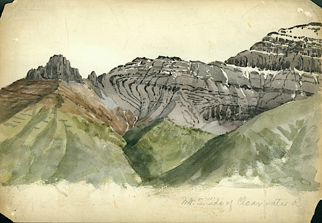
CLYDE PEAK PAINTED BY ARTHUR P. COLEMAN


ARTHUR P. COLEMAN (1852-1939), Clyde Peak (2,624 m - 8,610 f) United States of America (Montana)  In Mountain South Clide, watercolor on paper, 1895 A.P Coleman Funds.


ARTHUR P. COLEMAN (1852-1939)
Clyde Peak (2,624 m - 8,610 ft)
United States of America (Montana)

In Mountain South Clide, watercolor on paper, 1895 A.P Coleman Funds.


The mountain
Clyde Peak 2,624 m- is an 8,610 ft) is  located in Glacier National Park in the U.S. state of Montana. The mountain straddles the border shared by Flathead County and Glacier County. It is situated on the Continental Divide so precipitation runoff from the west side of the mountain drains into Thompson Creek which is part of the Middle Fork Flathead Riverwatershed, and the east side drains into headwaters of Red Eagle Creek, which flows to Red Eagle Lake, thence Saint Mary Lake. It is set in the Lewis Range, and the nearest higher neighbor is Mount Logan 1.44 mile to the northwest. Topographic relief is significant as the southwest aspect rises approximately 4,000 feet (1,220 meters) in one mile.
The mountain's name commemorates Norman Clyde (1885–1972), who made the first ascent of this peak on July 23, 1923.  Clyde is credited with 130 first ascents, most of which were in the Sierra Nevada of California.[ In 1923 he spent 36 days in Glacier National Park, Montana, where he climbed 36 mountains, including 11 first ascents.


The painter
Arthur Philemon Coleman was a Canadian a geologist, professor, minerals prospector, artist, Rockies explorer, backwoods canoeist, world traveller, scientist, popular lecturer, museum administrator, memoirist and... one of Canada’s most beloved scientist.
Arthur Coleman is a fine example of that rare bird, a polished amateur artist whose drawings and paintings stand comfortably beside those of many professionals. He was active during the time when sketching and painting was ceding to photography the task of recording the visible world. Although he was also a photographer, painting was, for him, both a poetic and a descriptive pursuit, a way of wrapping an artistic expression around a phenomenon he was interested in or moved by. Thus motivated, Coleman's paintings give much joy and command a good deal of respect. The more surprising, perhaps given that he used to introduced himself more as a geologist than a painter.
Coleman travelled throughout the United States for professional conferences as well as geological field work. He visited many of the major American mountain ranges including: the American Cordillera Mountains (Washington, Oregon and California); the Sierra Nevada Mountains (California and Nevada); Yellowstone National Park (Wyoming, Montana and Idaho); and the Appalachian Mountains (eastern United States). Pleistocene glaciation had extended in Northern Europe as far south as Berlin and London and covered an area of two million square miles. Coleman also visited such countries as India, Australia, Brazil, Argentina, Scandinavia, Bolivia, New Zealand, South Africa and Uruguay. In his final years he made two expeditions to the Andes in Colombia, to mountains in Southern Mexico and to two mountains in Central America. He achieved the first ascent of Castle Mountain in 1884, and in 1907, he was the first white man to attempt to climb Mount Robson. He made a total of eight exploratory trips to the Canadian Rockies, wholly four of them looking for the mythical giants of Hooker and Brown.
From 1901 to 1922, he was a Professor of Geology at the University of Toronto and was Dean of the Faculty of Arts from 1919 to 1922. From 1931 to 1934, he was a geologist with the Department of Mines of the Government of Ontario. He was elected a Fellow of the Royal Society of Canada in 1900 and was its President in 1921. In 1929, he was appointed Honorary Vice-President of the Royal Canadian Geographical Society.
"Mount Coleman" and "Coleman Glacier" in Banff National Park is named in his honor. He was awarded the Penrose Medal in 1936.
He planned to climb "his" mountain, "Mount Coleman"'in the Albertan Rockies, and had also prepared a trip to British Guiana, but death intervened.
He was author of:
- Reports on the Economic Geology of Ontario (1903)
- Lake Ojibway; Last of the Great Glacial Lakes (1909)
- The Canadian Rockies: New and Old Trails (1911)
- Ice Ages, Recent and Ancient (1926), and was co-author of Elementary Geology (1922).
- The Last Million Years (1941) edited by George F. Kay

 
___________________________________________
2021 - Wandering Vertexes...
by Francis Rousseau

Saturday, September 25, 2021

MONTE ROTONDO (CORSICA) SKETCHED BY JOHN MINTON

John Minton (1917-1957) Monte Rotondo (2,622 m -8,602 ft) France (Corse)  In Corte, Corsica, ink on paper,  1947, 40 x 24,3cm, Tate 
 
John Minton (1917-1957)
Monte Rotondo (2,622 m -8,602 ft)
France (Corse)

In Corte, Corsica, ink on paper,  1947, 40 x 24,3cm, Tate


About this work 
Minton visited Corsica in the late summer of 1947 with Alan Ross in connexion with their book Time was away, published by John Lehmann the following year; Minton did the illustrations, Ross the text. A group of Minton's drawings of views in Corsica was exhibited at the Lefevre Gallery in February 1949.

The mountain
Monte Rotondo (2,622 m - 8, 602 ft) visible from the town of Corte , Corsica (France) is the highest point of the second highest massif in the island ahead of those of Monte Renoso and Monte Incudine. It is located in the center of the island between the pits of Talcini, Venaco, Rogna and Sorroinsù. The summit overlooks, among others, Lake Bettaniella (on the south face), Lake Oriente and Lake Galiera (on the north face). Its main peaks are Monte Rotondo, Maniccia, Monte Cardo, Monte d'Oro, Punta Artica and Punta alle Porte.
l has long been considered the highest point on the island and was assigned an altitude of 2,746 meters. It has only been dethroned on the shelves by Monte Cinto for about a century. In 1802, André François Miot, Councilor of State appointed in Corsica by Bonaparte was the first to make the “tourist” ascent to the summit. With two other Corsican peaks, Monte Cinto and Monte Stello, Monte Rotondo served at the geodesic junction between Corsica and mainland France made by Paul Helbronner in 1925. The establishment of facilities such as the shelter have allowed the summit to be occupied for 14 days.

The artist
Francis John Minton was an English painter, illustrator, stage designer and teacher. After studying in France, he became a teacher in London, and at the same time maintained a consistently large output of works. In addition to landscapes, portraits and other paintings, some of them on an unusually large scale, he built up a reputation as an illustrator of books. In the mid-1950s, Minton found himself out of sympathy with the abstract trend that was then becoming fashionable, and felt increasingly sidelined. He suffered psychological problems, self-medicated with alcohol, and in 1957 died by suicide. In the Oxford Dictionary of National Biography's entry on Minton, Michael Middleton writes:
"Minton is often seen as an illustrator rather than a painter. He certainly extended and enriched the English graphic tradition. In all his varied output, however, may be sensed an elegiac awareness of the evanescence of physical beauty that is entirely personal. His work is to be found in the Tate collection, and many public and private collections at home and abroad. A retrospective exhibition of 1994, curated by his biographer, Frances Spalding, provided a convincing reminder of the range of his gifts. For the historian he must remain a potent symbol of his period."

 
___________________________________________
2021 - Wandering Vertexes...
by Francis Rousseau


Wednesday, September 22, 2021

THE CERVIN / MATTERHORN PAINTED BY GABRIEL LOPPÉ

GABRIEL LOPPÉ (1825-1913) Le Cervin or Matterhorn (4,478m -14,691ft) Switzerland - Italy border  In "Le Mont Cervin par temps nuageux, l'après midi", étude, huile sur toile 29x 18, 5cm, 1884.

GABRIEL LOPPÉ (1825-1913)
Le Cervin or Matterhorn (4,478m -14,691ft)
Switzerland - Italy border

In "Le Mont Cervin par temps nuageux, l'après midi", étude, huile sur toile 29x 18, 5cm, 1884.

The mountain
The Mont Cervin (4,478m -14,691ft) also known as the Matterhorn is an alpine summit located on the Swiss-Italian border between the canton of Valais and the Aosta Valley in Switzerland. It has several other names: Cervino in Italian, Grand'Bèca in Arpitan, Matterhorn in German. The Cervin / Matterhorn is the most famous mountain in Switzerland, including the pyramidal shape that it offers from the village of Zermatt, in the German-speaking part of the canton of Valais.
Its four sides are joined about 400 meters below the summit in a summit pyramid, called "roof." Its summit is a broad ridge about two meters, on which stand actually two summits: one called "Swiss summit," the farther east, and the "Italian summit" slightly lower (4,476 meters), on the west side of the ridge. The two are separated by a notch in the hollow of which a cross was laid in September 1901.
Its north face is one of the three great north faces of the Alps with the Eiger and the Grandes Jorasses.
The most famous faces of the Matterhorn are the faces east and north, seen from Zermatt. The first
1, 000 meters high, has great risk of falling rocks, which makes it dangerous climb. The north face high of 1100 meters, is one of the most dangerous sides of the Alps, particularly because of the risks of landslides and storms. The south side, overlooking the Breuil (Valtournenche above) is high, it, 1 350 meters. This is the face that offers the most channels. And finally, the west face the highest with its 1400 meters, is the one that is the subject of fewer climbs attempts. Between the west side and the north side there is also the north-northwest side, which does not stretch to the summit but stopped Zmutt Nose, on the bridge of the same name. This is the most dangerous route for climbing the Matterhorn. There is also a south-facing southeast, deemed to be the most difficult of the south face route, which leads to the Pic Muzio, on Furggen Shoulder.
Due to its pyramidal form, the Matterhorn has four main ridges, through which pass most of climbing routes. The easiest ridge, that borrows the normal route, is the Hörnli ridge (Hörnligrat in German): it is between the faces east and north, facing the Zermatt valley. Further west lies the Zmutt ridge (Zmuttgrat), between the north and west sides. Between the western and southern sides is the Lion ridge (Liongrat), also known as Italian ridge, which passes through the Tyndall peak, summit of the southern part of the west side, at which begins the upper face. Finally, the south side is separated from the face is Furggen
Swiss normal route from the cabin of the Hörnli, located at 3260 meters. Since Zermatt is accessed by gondola Schwarzsee; there are 700 vertical meters to the hut and 1200 vertical meters to the summit.
Difficulty (Hörnli ridge): AD (fairly difficult), 3 climbing passage; fixed ropes were installed near the top for easy ascension.
The Italian normal route, taking his departure in Breuil, follows almost entirely the southwest ridge, called the Lion ridge. It was inaugurated by the guide valtournain Jean-Antoine Carrel 17 July 1865.
The climb from the Italian side includes three steps:
- du Breuil (2012 meters) at the shelter Duke of Abruzzi in Oriondé (2802 meters)
- the refuge Duca degli Abruzzi refuge to Jean-Antoine Carrel (3830 meters)
- Jean-Antoine Carrel refuge at the summit (4478 meters).
The ascent by Hörnli ridge, July 14, 1865, was considered the last of the great feats of mountaineering in the Alps. But this ascent error ended at the beginning of the descent, in the death of 4 of the 7 members of the roped Victorieuse.

The painter
Toussaint Gabriel Loppé was a French painter, photographer and mountaineer. He became the first foreigner to be made a member of the Alpine Club in London. His father was a captain in the French Engineers and Loppé's childhood was spent in many different towns in south-eastern France. Aged twenty-one Loppé climbed a small mountain in the Languedoc and found a group of painters sketching on the summit. He had found his calling and subsequently went off to Geneva where he met the reputed leading Swiss landscapist, Alexandre Calame (1810 -1864). Loppé took up mountaineering in Grindelwald in the 1850s and made friends easily with the many English climbers in France and Switzerland. Although he was frequently labelled as a pupil of Calame and his rival François Diday, Loppé was almost an entirely self-taught artist. He became the first painter to work at higher altitudes during climbing expeditions earning the right to be considered the founder of the peintres-alpinistes school, which became established in the Savoie at the turn of the nineteenth century.
Notable followers of Loppé include, Charles Henri Contencin (1875-1955) and Jacques Fourcy (1906-1990). Together with the first ascent of Mt Mallet in Chamonix’s Grandes Jorasses range, Loppé made over 40 ascents of Mont Blanc during his climbing career, which lasted until the late 1890s. He frequently made oil sketches from alpine summits, including a panorama of the view from the summit of Mont Blanc.
His paintings became celebrated for their atmosphere and spontaneity and he soon found himself taking part in many exhibitions in London and in Paris.
By 1896 Loppé had spent over fifty seasons climbing and painting in Chamonix. As the valley’s unrivalled ‘Court painter’ his work was in constant demand with the majority of his pictures going to English climbers and summer tourists.
In his later years, Loppé became fascinated with photography and was quite an innovator in this field too. His long exposure photograph of the Eiffel Tower struck by lightning, now in the Musée d'Orsay in Paris remains one of his iconic images.

___________________________________________

2021 - Wandering Vertexes...
by Francis Rousseau


Sunday, September 19, 2021

COBB MOUNTAIN PAINTED BY GIDEON JACQUES DENNY


GIDEON JACQUES DENNY (1830-1886),  Cobb Mountain 1440 m - 4723ft United States of America (California)   In City of Lake Port on Clear Lake, 1876. Oil on canvas, Crocker Art Museum

GIDEON JACQUES DENNY (1830-1886)
Cobb Mountain (14,40 m - 4,723 ft)
United States of America (California) 


In City of Lake Port on Clear Lake, 1876. Oil on canvas. Crocker Art Museum, Sacramento 


The painter
Gideon Jacques Denny (1830–1886) was a landscape artist speciailized in marine artist. So the mountains painted in his works are always more or less "accidental" ! Born in Wilmington, Delaware on July 15, 1830, he worked on ships in the Chesapeake Bay. He traveled to California in 1849 with the Gold Rush. He worked as a teamster on the San Francisco docks and was a member of the San Francisco Committee of Vigilance. After two years in California, he moved to Milwaukee, where he studied painting with Samuel Marsden Brookes. After six years of study in Milwaukee, Denny returned to San Francisco and established a studio on Bush Street. In 1862, Brookes moved to San Francisco and shared a studio with Denny. In 1868, Denny spent two months in Hawaii visiting several islands. He is also known to have visited Canada and South America. Denny died of malaria in Cambria. The Berkeley Art Museum and Pacific Film Archive, the Bishop Museum (Honolulu), the Crocker Art Museum (Sacramento, California), the Fine Arts Museums of San Francisco, Monterey Peninsula Museum of Art, and the Oakland Museum of California are among the public collections holding works by Gideon Jacques Denny.

The mountain
The Lakeport area is located on a sediment-filled valley adjacent to Clear Lake. The majority of faults in the County are located in the Cobb Mountain area. Cobb Mountain (1,440 m- 4,720 feet ) is the tallest mountain in the Mayacamas Mountains of California. The mountain also has a sub-peak named Cobb Mountain – Southwest Peak (1367 m- 4483 ft). Southwest Peak lies on the Sonoma-Lake county line and is the highest point in Sonoma County. Nearby tall peaks like Mount Saint Helena and Snow Mountain can be seen from this summit. Cobb Mountain is one of the mountains in the Cobb Mountain Area, many of which have volcanic origin. Others are Boggs Mountain, Mount Hannah and Seigler Mountain. There are isolated small valleys and basins between the mountain peaks. The east end of Cobb Mountain drains into the headwaters of Putah Creek, then into the Sacramento River, the San Francisco Bay, and the Pacific Ocean. The south slopes of Cobb Mountain drain into Anderson Creek, and thence into Putah Creek. The southwest slopes of Cobb Mountain drain into Cobb Creek, thence into Big Sulphur Creek, the Russian River, and into the Pacific. The northwest slopes of Cobb Mountain drain into Alder Creek, thence into Kelsey Creek, Clear Lake, Cache Creek, and the Sacramento River. The northeast slopes of Cobb Mountain drain into Kelsey Creek. Much of Cobb Mountain lies within The Geysers Geothermal Field, and several geothermal plants are located on the mountain. Other areas on the mountain are owned by Cobb Mountain Spring Water (now sold as Mayacamas Mountain Spring Water) or are privately held timberlands. Because much of Cobb Mountain is privately owned, it is largely not accessible to the general public. The mountain is named after John Cobb, the first pioneer to settle in the area. In 1853 he arrived in California and homesteaded in Cobb Valley and went on to become the county assessor and the road overseer for the Clearlake District in 1855. He built a combined saw and gristmill in 1859, which was later destroyed by fire. He sold his interests and moved to Napa County around 1860. The Cobb Mountain area was devastated in 2015 by the Valley Fire, including much of the town of Cobb, as well as several geothermal facilities.

___________________________________________

2021 - Wandering Vertexes...
by Francis Rousseau


Thursday, September 16, 2021

THE EIGER SKETCHED BY JOHN SINGER SARGENT

JOHN SINGER SARGENT (1856-1925) The Eiger (3,970 m -13,020 ft) Switzerland  In Eiger from Mürren (from “Splendid Mountain Watercolours” Sketchbook), 40.6 x 27.6 cm, Watercolor and graphite, The MET (Gift of Mrs. Francis Ormond, 1950. Public Domain.

JOHN SINGER SARGENT (1856-1925)
The Eiger (3,970 m -13,020 ft)
Switzerland


In Eiger from Mürren (from Splendid Mountain Watercolours Sketchbook),
Watercolor and graphite, 40.6 x 27.6 cm,
The MET (Gift of Mrs. Francis Ormond, 1950. Public Domain.


The painter
John Singer Sargent was an American artist who created roughly 900 oil paintings and more than 2,000 watercolors, as well as countless sketches and charcoal drawings. His oeuvre documents worldwide travel, from Venice to the Tyrol, Switzerland, Corfu, the Middle East, Montana, Maine, and Florida.
He was trained in Paris prior to moving to London. Sargent enjoyed international acclaim as a portrait painter, but in later life he expressed ambivalence about the restrictions of formal portrait work, and devoted much of his energy to mural painting and working en plein air. He lived most of his life in Europe. Each destination offered pictorial stimulation and treasure. Even at his leisure, in escaping the pressures of the portrait studio, he painted with restless intensity, often painting from morning until night. His hundreds of watercolors of Venice are especially notable, many done from the perspective of a gondola. His colors were sometimes extremely vivid and as one reviewer noted, "Everything is given with the intensity of a dream." In the Middle East and North Africa Sargent painted Bedouins, goatherds, and fisherman. In the last decade of his life, he produced many watercolors in Maine, Florida, and in the American West, of fauna, flora, and native peoples.
With his watercolors, Sargent was able to indulge his earliest artistic inclinations for nature, architecture, exotic peoples, and noble mountain landscapes. And it is in some of his late works where one senses Sargent painting most purely for himself. His watercolors were executed with a joyful fluidness. His first major solo exhibit of watercolor works was at the Carfax Gallery in London in 1905. In 1909, he exhibited eighty-six watercolors in New York City, eighty-three of which were bought by the Brooklyn Museum. Evan Charteris wrote in 1927: 'To live with Sargent's water-colours is to live with sunshine captured and held, with the luster of a bright and legible world, 'the refluent shade' and 'the Ambient ardours of the noon.'
Although not generally accorded the critical respect given Winslow Homer, perhaps America's greatest watercolorist, scholarship has revealed that Sargent was fluent in the entire range of opaque and transparent watercolor technique, including the methods used by Homer.


The mountain
The Eiger (3,970m- 13,020 ft) is located in the Bernese Alps, overlooking Grindelwald and Lauterbrunnen in the Bernese Oberland, just north of the main watershed and border with Valais. It is the easternmost peak of a ridge crest that extends across the Mönch to the Jungfrau at (4,158 m-13,642 ft), constituting one of the most emblematic sights of the Swiss Alps. While the northern side of the mountain rises more than 3,000m -10,000 ft above the two valleys of Grindelwald and Lauterbrunnen, the southern side faces the large glaciers of the Jungfrau-Aletsch area, the most glaciated region in the Alps. The most notable feature of the Eiger is its 1,800-metre-high - 5,900 ft north face of rock and ice, named Eigerwand or Nordwand, which is the biggest north face in the Alps. This huge face towers over the resort of Kleine Scheidegg at its base, on the homonymous pass connecting the two valleys.
The first ascent of the Eiger was made by Swiss guides Christian Almer and Peter Bohren and Irishman Charles Barrington, who climbed the west flank on August 11, 1858.
The north face, considered amongst the most challenging and dangerous ascents, was first climbed in 1938 by an Austrian-German expedition with Anderl Heckmair, Ludwig Vцrg, Heinrich Harrer and Fritz Kasparek. The Eiger has been highly-publicized for the many tragedies involving climbing expeditions.
In 1973 : first all female ascent of the face by Wanda Rutkiewicz, Danuta Gellner-Wach and Stefania Egierszdorff. All Polish.
In June 2006, François Bon and Antoine Montant make the first speedflying descent of the Eiger
Since 1935, at least sixty-four climbers have died attempting the north face, earning it the German nickname Mordwand, literally "murder(ous) wall"—a pun on its correct title of Nordwand (North Wall).
Although the summit of the Eiger can be reached by experienced climbers only, a railway tunnel runs inside the mountain, and two internal stations provide easy access to viewing-windows carved into the rock face. They are both part of the Jungfrau Railway line, running from Kleine Scheidegg to the Jungfraujoch, between the Mцnch and the Jungfrau, at the highest railway station in Europe. The two stations within the Eiger are Eigerwand (behind the north face) and Eismeer (behind the south face), at around 3,000 metres.
The Eiger is mentioned in records dating back to the 13th century, but there is no clear indication of how exactly the peak gained its name. The three mountains of the ridge are commonly referred to as the Virgin (German: Jungfrau – translates to "virgin" or "maiden"), the Monk (Mцnch), and the Ogre (Eiger; the standard German word for ogre is Oger). The name has been linked to the Latin term acer, meaning "sharp" or "pointed", but more commonly to the German eigen, meaning "own".

___________________________________________

2021 - Wandering Vertexes...
by Francis Rousseau


Tuesday, September 14, 2021

MOUNT HERDUBREID PAINTED BY SVEINN THÓRARINSSON

SVEINN THÓRARINSSON (1899 -1977),  Herðubreið  / Mount Herdubreid (1,682 m - 5518ft),  Iceland,  In Herðubreið, oil on canvas, 1926,

 
SVEINN THÓRARINSSON (1899 -1977) 
Herðubreið  / Mount Herdubreid (1,682 m - 5518ft) 
Iceland

 In Herðubreið, oil on canvas, 1926


Biography of the painter  
Sveinn Thórarinsson (in our alphabet Thorarinsson) and his wife Karen Agnete thórarinsson were both painters. Sveinn's parents were farmers in Kílakot (Iceland) but the family has maintained a strong tradition of artistic activities for several generations. Born in this very small and sparsely populated island that is Iceland, Sveinn Thórarinsson grew up, without knowing it, in a family that had a strong artistic reputation among its neighbors! His parents therefore brought him up naturally as an artist and in particular by making him play the violin like his father. Child, very puny, unable to compete with other adolescents in the work in the fields, he was sent to study music in the city. The music could therefore have occupied his mind completely, but it was not.
After successful studies in Reykjavik, he returned home and decided to paint while continuing to make music. He was suddently so active as a painter that people came to see his works from all the farms around! As his paintings were popular, he quickly became a renowned painter in Iceland, which was hardly surprising given the family he came from. For a long time he continued to play the violin and paint, at the same time, including frescoes in chapels drowned in snow. For several years, he painted and sold his works regularly, thus amassing a certain amount of money, which allowed him to face the wide world.
In the fall of 1925, he left to study at the Academy of Fine Arts.
Then his career as a painter, carried out mainly within his island, will carry him peacefully until his death.
Since then his price in the auction rooms has continued to rise and he appears as one of the great Icelandic painters of the twentieth century painting in a style which is very much inspired by that of Cezanne and the French impressions, which he knew mainly from books ...

 
The mountain
Herðubreið (1,682 m - 5,518 ft) meaning broad-shouldered is a tuya in northern part of Vatnajökull National Park, Iceland. It is situated in the Highlands of Iceland at the east side of the Ódáðahraun desert and close to Askja volcano. The desert is a large lava field originating from eruptions of Trölladyngja and other shield volcanoes in the area. Herðubreið was formed beneath the icesheet that covered Iceland during the last glacial period. The mountain is often referred to as "The Queen of Icelandic Mountains" by Icelanders due to its beautiful shape. Near the mountain lies an oasis called Herðubreiðarlindir with a campground and hiking trails. In former times, outcasts who had been excluded from Icelandic society because of crimes they had committed lived at the oasis. One such outlaw was Fjalla-Eyvindur, who lived there during the winter of 1774–1775. In 2019 Herðubreið became a part of Vatnajökull National Park.


___________________________________________
2021 - Wandering Vertexes...
by Francis Rousseau

Sunday, September 12, 2021

MOUNT GILES PAINTED BY ALBERT NAMATJIRA


ALBERT NAMATJIRA (1902-1959) Mount Giles (1, 389 m - 4, 557 ft) Australia (Northern territory),  In Yuendumu, watercolor, 1948


ALBERT NAMATJIRA (1902-1959)
Mount Giles (1, 389 m - 4, 557 ft)
Australia (Northern territory) 

In Yuendumu, watercolor, 1948

The mountain
Mount Giles (1, 389 m - 4, 557 ft) is one of the highest mountains in the Northern Territory, Australia. It lies along the MacDonnell Ranges, dominating Ormiston Pound, in the West MacDonnell National Park, approximately 80 kilometres (50 mi) west of Alice Springs. It can be visited via the celebrated Larapinta Trail and has views of Mount Sonder, Ormiston Gorge and Pound, and the surrounding range. Climbing the mountain requires a hard two- or three-day hike. The MacDonnell Ranges is located in the Northern Territory, comprising 3,929,444 hectares (9,709,870 acres). The range is a 644 km (400 mi) long series of mountains located in the centre of Australia, and consist of parallel ridges running to the east and west of Alice Springs. The mountain range contains many spectacular gaps and gorges as well as areas of Aboriginal significance.
The ranges were named after Sir Richard MacDonnell (the Governor of South Australia at the time) by John McDouall Stuart, whose 1860 expedition reached them in April of that year. The Horn Expedition investigated the ranges as part of the scientific expedition into central Australia. Other explorers of the range included David Lindsay and John Ross.
The MacDonnell Ranges are famous to have been often depicted in the paintings by Albert Namatjira.

The painter
Albert Namatjira born Elea Namatjira, was a Western Arrernte-speaking Aboriginal artist from the MacDonnell Ranges in Central Australia. As a pioneer of contemporary Indigenous Australian art, he was the most famous Indigenous Australian of his generation.
Born and raised at the Hermannsburg Lutheran Mission outside Alice Springs, Namatjira showed interest in art from an early age, but it was not until 1934 (aged 32), under the tutelage of Rex Battarbee, that he began to paint seriously. Namatjira's richly detailed, Western art-influenced watercolours of the outback departed significantly from the abstract designs and symbols of traditional Aboriginal art, and inspired the Hermannsburg School of painting. He became a household name in Australia—indeed, reproductions of his works hung in many homes throughout the nation—and he was publicly regarded as a model Aborigine who had succeeded in mainstream society.
Although not the first Aboriginal artist to work in a European style, Albert Namatjira is certainly the most famous. Ghost gums with luminous white trunks, palm-filled gorges and red mountain ranges turning purple at dusk are the hallmarks of the Hermannsburg school. Hermannsburg Mission was established by Lutheran missionaries in 1877 on the banks of the Finke River, west of Mparntwe (Alice Springs). Namatjira learnt watercolour technique from the artist, Rex Battarbee.
Initially thought of as having succumbed to European pictorial idioms – and for that reason, to ideas of European privilege over the land – Namatjira’s landscapes have since been re-evaluated as coded expressions on traditional sites and sacred knowledge. Ownership of country is hereditary, but detailed knowledge of what it ‘contains’ is learnt in successive stages through ceremony, song, anecdote and contact. Namatjira’s father’s country lay towards Mount Sonder and Glen Helen Gorge, in the MacDonnell Ranges, and his mother’s country was in the region of Palm Valley in Central Australia. In Namatjira’s paintings, the totemic connections to his country are so indelible that, for example, Palm Valley the place and Palm Valley, c.1940s, the painting seem to intersect, detailing Namatjira’s artistic, cultural and proprietorial claim on the land.
One of his first landscapes from 1936, Central Australian Landscape, shows a land of rolling green hills. Another early work, Ajantzi Waterhole (1937), shows a close up view of a small waterhole, with Namatjira capturing the reflection in the water. The landscape becomes one of contrasting colours, a device that is often used by Western painters, with red hills and green trees in Red Bluff (1938). Central Australian Gorge (1940) shows detailed rendering of rocks and reflections in the water. In Flowering Shrubs Namatjira contrasts the blossoming flowers in the foreground with the more barren desert and cliffs in the background. Namatjira's love of trees was often described so that his paintings of trees were more portraits than landscapes, which is shown in the portrait of the often depicted ghost gum in Ghost Gum Glen Helen (c.1945-49). Namatjira's skills at colouring trees can be clearly seen in this portrait. Namatjira was fully aware of his own talent, as was shown when he was describing another landscape painter to William Dargie: "He does not know how to make the side of a tree which is in the light look the same colour as the side of the tree in shadow...I know how to do better."
Namatjira's skills kept increasing with experience as is shown in the highly photographic quality of Mt Hermannsburg (1957), painted only two years before he died.
In 1957, Namatjira became the first Aboriginal person to be granted conditional Australian citizenship. This entitled him to limited social freedoms and to live in Mparntwe, although he was prohibited from purchasing land. His relations, including his children, were not permitted the same privileges.
After an incident in 1958 that didn’t directly involve the artist, Namatjira was charged with supplying alcohol to members of the Aboriginal community – at the time, it was illegal for all Aboriginal people, except Namatjira, to possess and consume alcohol. Namatjira was sentenced to six months labour at Papunya and this, exacerbated by the authorities’ refusal to allow him to purchase the land of his ancestors, caused him profound despair. He served only two months, and died shortly after.
The more recent, dramatic success of the nearby Papunya Tula movement must be read against the history of its predecessor, the Hermannsburg school, which has endured for over half a century. In 2002, the centenary of Namatjira’s birth was celebrated with a major retrospective at the National Gallery of Australia, Canberra.

___________________________________________
2021 - Wandering Vertexes...
by Francis Rousseau
Friday, September 10, 2021

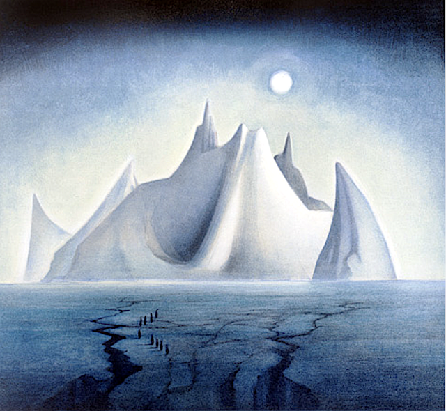
TROLLSLOTTET MOUNTAIN PAINTED BY VEJBJØRN SAND


VEJBJØRN SAND (bn. 1966), Trollslottet mountain (2,737 m- 8,930 ft) Antarctica,   In  Trollslottet, 1997, Antarctica


VEJBJØRN SAND (bn. 1966)
Trollslottet mountain (2,737 m- 8,930 ft)
Antarctica

In Trollslottet, 1997, Antarctica  


About this Painting
After an expedition to Antarctica, Queen Maud Land (Independent Norwegian territory in Antarctica) , Vebjørn completed his first public work, The Troll Castle (Trollslottet) which was inspired by the voyage. In collaboration with the team who arranged the opening of the Winter Olympics at Lillehammer in 1994, Vebjørn constructed a “Mini Antarctica” formed by 10 towers surrounding a circle, all reminiscent of Arnesteinen, a mountain shooting out of the ice in the shape of a cathedral. Inside the castle Vebjørn included paintings (as the one above) conceived and executed in Antarctica, stored inside glass boxes to resemble ice. The castle was designed so that visitors could walk inside the space and experience a frigid atmosphere similar to the one Vebjørn did when he painted them. During the first 3 months of its opening in the winter of 1997/98, 180,000 people visited the Troll Castle.


The mountain
Trollslottet Mountain (2,737m - 8,930ft) situated at 71°56′S 7°14′E, is a high ridgelike mountain with several prominent peaks  forming the northwest limit of the Filchner Mountains in Queen Maud Land (Independant Norwegian territory in Antarctica). Plotted from surveys and air photos by Norwegian Antarctic Expedition (1956–60) and named Trollslottet (the troll castle). The Filchner Mountains are a group of mountains 11 km (7 mi) southwest of the Drygalski Mountains, at the western end of the Orvin Mountains of Queen Maud Land, Antarctica. They were discovered by the Third German Antarctic Expedition (1938–1939), led by Capt. Alfred Ritscher, and named for Wilhelm Filchner, leader of the German expedition to the Weddell Sea area in 1911–12. They were remapped from air photos taken by the Sixth Norwegian Antarctic Expedition, 1958–59

The Painter
Vebjørn Sand (born March 11, 1966) is a Norwegian painter and artist. He is known for his paintings as well as his public arts projects, such as the Da Vinci Project, and the Kepler Star monument (Norwegian Peace Star) at Oslo Airport, Gardermoen.
Building off the original Da Vinci bridge in Norway, Vebjørn used Leonardo's philosophy of encompassing all fields of research to use the project to discuss global warming. First he used ice to reinterpret and construct a new bridge during his expedition to Queen Maud Land in Antarctica. After that, in December of 2007, Vebjørn erected a temporary ice bridge to dramatize the melting glaciers of Antarctica due to climate change outside of the United Nations Plaza in New York. During the unveiling at the U.N. Headquarters, Vebjørn said of the bridge in Antarctica,
“Our future lays underneath that ice glacier. So to erect it on that glacier, and that part of Antarctica, (it) must never melt. The one outside the United Nations is intended to melt to show that Antarctica is melting.”
The bridge was unveiled earlier that year two days after nearly 200 nations agreed at the U.N.-led talks in Bali to launch negotiations on a new pact to fight global warming.
In 2009, Vebjørn built another ice bridge in Ilulissat, Greenland (where most icebergs are borne into the sea). Later that year in Copenhagen, as part of the United Nations Climate Change Conference, also known as COP15, Vebjørn constructed yet another ice bridge in front of the Danish Parliament to raise global awareness of climate change.


___________________________________________


2021 - Wandering Vertexes...

by Francis Rousseau 


Wednesday, September 8, 2021

MOUNT KILIMANDJARO PAINTED BY PILLY TURNER

PILLY TURNER (active 1955-1970)
 Kilimandjaro (5,885m - 19,340ft)n 
Tanzania,  In Kilimandjaro from Tanzania's Lake Chala, oil on canvas, 1961, Private Collection

PILLY TURNER (active 1955-1970)

Kilimandjaro (5,885m - 19,340ft)

Tanzania

In Kilimandjaro from Tanzania's Lake Chala, oil on canvas, 1961, Private Collection 


The mountain

Mount Kilimanjaro (5,885m - 19, 340ft) is a dormant volcano in Tanzania composed of three volcanic cones, "Kibo", "Mawenzi", and "Shira. The Kilimandjaro is the highest mountain in Africa. The first recorded ascent to the summit was by Hans Meyer and Ludwig Purtscheller in 1889.
The mountain is part of the Kilimanjaro National Park and is a major climbing destination. The mountain has been the subject of many scientific studies because of its shrinking glaciers, especially since 200.
The origin of the name "Kilimanjaro" is not precisely known, but a number of theories exist. European explorers had adopted the name by 1860 and reported that "Kilimanjaro" was the mountain's Kiswahili name. The 1907 edition of The Nuttall Encyclopædia also records the name of the mountain as "Kilima-Njaro", as well as the title of the watercolor above. Johann Ludwig Krapf wrote in 1860 that Swahilis along the coast called the mountain Kilimanjaro. Although he did not support his claim, he claimed that "Kilimanjaro" meant either "mountain of greatness" or "mountain of caravans". Under the latter meaning, "Kilima" meant "mountain" and "Jaro" possibly meant "caravans". Jim Thompson claimed in 1885, although he also did not support his claim, that the term Kilima-Njaro "has generally been understood to mean" the Mountain (Kilima) of Greatness (Njaro). Though not improbably it may mean the "White" mountain. "Njaro" is an ancient Kiswahili word for "shining". Others have assumed that "Kilima" is Kiswahili for "mountain".
In the 1880s, the mountain became a part of German East Africa and was called "Kilima-Ndscharo" in German following the Kiswahili name components.
On 6 October 1889, Hans Meyer reached the highest summit on the crater ridge of Kibo. He named it "Kaiser-Wilhelm-Spitze" ("Kaiser Wilhelm peak").
That name apparently was used until Tanzania was formed in 1964, when the summit was renamed "Uhuru", meaning "Freedom Peak" in Kiswahili.The mountain Mount Kilimanjaro (5,885m - 19, 340ft) is a dormant volcano in Tanzania composed of three volcanic cones, "Kibo", "Mawenzi", and "Shira. The Kilimandjaro is the highest mountain in Africa. The first recorded ascent to the summit was by Hans Meyer and Ludwig Purtscheller in 1889.
The mountain is part of the Kilimanjaro National Park and is a major climbing destination. The mountain has been the subject of many scientific studies because of its shrinking glaciers, especially since 2000....


The artist

Pilly Turner is a kenyan watercolourist, active during the 1955-1970 's. The watercolor she painted are always very realistic, and with exemples of wild life animals and animals of the country. There are no other information available about this artist and only a few amount of paintings on the art market (more than 10).


___________________________________________


2021 - Wandering Vertexes...

by Francis Rousseau 


Saturday, September 4, 2021

GIEWONT MASSIF PAINTED BY LEON JAN WYCZÓLKOWSKI


LEON JAN WYCZÓLKOWSKI (1852-1936) Giewont Massif (1, 895 m- 6, 217 ft) Poland  In Giewont w śniegu (Giewont in the snow), pastel, 1905, Katowice Museum/Muzeum Śląskie w Katowicach, Poland

LEON JAN WYCZÓLKOWSKI (1852-1936)
Giewont Massif (1, 895 m- 6, 217 ft)
Poland

In Giewont w śniegu (Giewont in the snow), pastel, 1905, 
Katowice Museum/Muzeum Śląskie w Katowicach, Poland

The painter 
Leon Jan Wyczółkowski (1852-1936) was one of the leading painters of the Young Poland movement, as well as the principal representative of Polish Realism in art of the Interbellum. From 1895 to 1911 he served as professor of the Jan Matejko Academy of Fine Arts (ASP) in Kraków, and from 1934, ASP in Warsaw. He was a founding member of the Society of Polish Artists "Sztuka" (Art, 1897). Wyczółkowski was born in Huta Miastowska near Garwolin in Congress Poland. At first, in his artistic experience he aimed at devoting himself to the genre of historical painting with documentary realism in the detail. After his trip to Paris though, he changed his focus and began implementing solutions typical of the French Impressionists. He painted dramatic landscapes, nudes and pastoral scenes with impasto and impressionist lighting effects . For a short while he came under the influence of Symbolism, and around 1900 darkened his palette. His work is characterized by a richness of form and complex technical means. Thanks to a friendship with Feliks Manggha Jasieński, he expanded his interests to include oriental scenes as well. Wyczółkowski was a master of flower arrangements and still life. He portrayed almost the entire art world of Kraków.  Wyczółkowski died 1936 in Warsaw. After the war, on the anniversary of his birthday (11 April 1946), the District Museum in Bydgoszcz took up his name in recognition of his outstanding achievements. His widow donated to the Museum many of his paintings, drawings and a lot of personal memorabilia, including studio equipment. The collection, organized into a new department, consists of over 700 works of Leon Wyczółkowski. His most representative impressionist paintings can be found at the National Museum, Kraków and at the National Museum, Warsaw.
 
The mountain
Giewont is a mountain massif in the Tatra Mountains of Poland. It  is 1,895 m - at its highest.
The massif has three peaks (all m/metres in AMSL):
- Great Giewont - Wielki Giewont (1,895 m- 6, 217 ft)
- Long Giewont - Długi Giewont (1,867 m- 6, 125 ft)
- Small Giewont - Polish Mały Giewont (1,728 m - 5,669 ft)
There is a mountain pass located between Great and Long Giewont, known as Szczerba (1,823 m- 5, 980 ft). Long Giewont and Great Giewont are situated at a higher altitude than the nearby town of Zakopane, making them clearly visible from that city.
On Great Giewont, there is a 15 m steel cross (erected in 1901) - the site of religious pilgrimages. The area is notorious for its hazardous nature during thunderstorms, so this should be taken into consideration when approaching the summit.
The first recorded ascent to Giewont's summit was undertaken in 1830 by Franciszek Herbich and Aleksander Zawadzki (a19th century explorer). The first winter ascent of Giewont occurred in 1904 by a group of five mountaineers led by Mariusz Zaruski. Nowadays the climbing on Giewont is strictly banned. On the other hand, hiking on the hiking trails is allowed and the access (except the winter) is not difficult hence Giewont is a very popular destination among amblers and Sunday tourists. In the summer up to few thousands tourists a day ascend the top.

_______________________________

2021 - Wandering Vertexes...
by Francis Rousseau

Wednesday, September 1, 2021

MOUNT SNOWDON PAINTED BY J.M.W. TURNER


J.M.W. Turner (1775-1851), Mount Snowdon (1, 085 m -3,560 ft), United Kingdom (Wales),  In  "Mount Snowdon, Afterglow ", oil on canvas, 1800, Tate 
 
J.M.W. Turner (1775-1851)
Mount Snowdon (1, 085 m -3,560 ft)
United Kingdom (Wales)

In Mount Snowdon, Afterglow, oil on canvas, 1800, Tate

The mountain
Mount Snowdon (1, 085 m -3,560 ft),Yr Wyddfa in welsh, is the highest mountain in Wales and the highest point in the British Isles south of the Scottish Highlands. A 1682 survey estimated that the summit of Snowdon was at a height of 1,130 m - 3,720 feet ; in 1773, Thomas Pennant quoted a later estimate of 1,088 m- 3,568 ft above sea level at Caernarfon. Recent surveys give the height of the summit as 1,085 m -3,560 ft. The name Snowdon is from the Old English for "snow hill", while the Welsh name – Yr Wyddfa – means "the tumulus" or "the barrow", which may refer to the cairn thrown over the legendary giant Rhitta Gawr after his defeat by King Arthur. As well as other figures from Arthurian legend, the mountain is linked to a legendary Afanc (water monster) and the Tylwyth Teg (fairies). Mount Snowdon is located in Snowdonia National Park (Parc Cenedlaethol Eryri) in Gwynedd. It has been described as "probably the busiest mountain in Britain", with approximately 444,000 people having walked up the mountain in 2016. It is designated as a national nature reserve for its rare flora and fauna. The rocks that form Snowdon were produced by volcanoes in the Ordovician period, and the massif has been extensively sculpted by glaciation, forming the pyramidal peak of Snowdon and the Arêtes of Crib Goch and Y Lliwedd. The cliff faces on Snowdon, including Clogwyn Du'r Arddu, are significant for rock climbing, and the mountain was used by Edmund Hillary in training for the 1953 ascent of Mount Everest.
The summit can be reached by a number of well-known paths, and by the Snowdon Mountain Railway, a rack and pinion railway opened in 1896 which carries passengers the 4.7 miles (7.6 km) from Llanberis to the summit station.

The painter
The english painter Joseph Mallord William Turner was considered a controversial figure in his day, but is now regarded as the artist who elevated landscape painting to an eminence in the history of painting. Although renowned for his oil paintings, Turner is also one of the greatest masters of British watercolour landscape painting.  He is commonly known as "the painter of light" and his work is regarded as a Romantic preface to Impressionism.
In his thirties, Turner travelled widely in Europe, starting with France and Switzerland in 1802 and studying in the Louvre in Paris in the same year. He made many visits to Venice.  Turner's talent was recognized early in his life. Financial independence allowed Turner to innovate freely; his mature work is characterized by a chromatic palette and broadly applied atmospheric washes of paint. According to David Piper's The Illustrated History of Art, his later pictures were called "fantastic puzzles:" Turner was recognized as an artistic genius: influential English art critic John Ruskin described him as the artist who could most "stirringly and truthfully measure the moods of Nature."
Turner's major venture into printmaking was the Liber Studiorum (Book of Studies), seventy prints that he worked on from 1806 to 1819. The Liber Studiorum was an expression of his intentions for landscape art. The idea was loosely based on Claude Lorrain's Liber Veritatis (Book of Truth), where Lorrain had recorded his completed paintings; a series of print copies of these drawings, by then at Devonshire House, had been a huge publishing success. Turner's plates were meant to be widely disseminated, and categorized the genre into six types: Marine, Mountainous, Pastoral, Historical, Architectural, and Elevated or Epic Pastoral. His printmaking was a major part of his output, and a museum is devoted to it, the Turner Museum in Sarasota, Florida, founded in 1974 by Douglass Montrose-Graem to house his collection of Turner prints.
Turner placed human beings in many of his paintings to indicate his affection for humanity on the one hand (note the frequent scenes of people drinking or working or walking in the foreground), but its vulnerability and vulgarity amid the 'sublime' nature of the world on the other. 'Sublime' here means awe-inspiring, savage grandeur, a natural world unmastered by man, evidence of the power of God – a theme that romanticist artists and poets were exploring in this period. Although these late paintings appear to be 'impressionistic' and therefore a forerunner of the French school, Turner was striving for expression of spirituality in the world, rather than responding primarily to optical phenomena.
Turner used pigments like carmine in his paintings, knowing that they were not long-lasting, despite the advice of contemporary experts to use more durable pigments. As a result, many of his colours have now faded greatly.
John Ruskin says in his "Notes" on Turner in March 1878 : "His true master was Dr Monro; to the practical teaching of that first patron and the wise simplicity of method of watercolour study, in which he was disciplined by him and companioned by Girtin, the healthy and constant development of the greater power is primarily to be attributed; the greatness of the power itself, it is impossible to over-estimate. "

_______________________________
2021 - Wandering Vertexes...
by Francis Rousseau