Wednesday, April 28, 2021

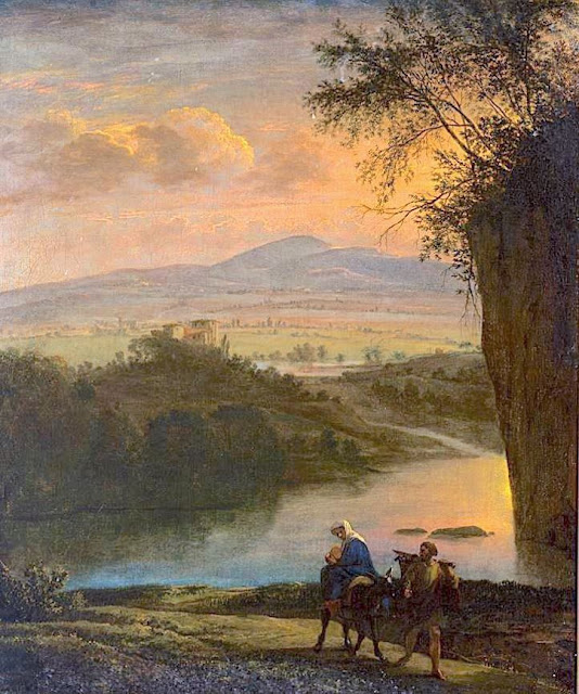
MOUNT SINAI / JABAL MUSA PAINTED BY JAN ASSELIJN

Jan Asselijn (c.1610 – October 1, 1652) Mount Sinaï / Jabal Musa (2,285 m - 7,496ft) Egypt In Flight into Egypt, c. 1640, oil on canvas, Rijksmuseum, Amsterdam


Jan Asselijn (c.1610 – October 1, 1652)
Mount Sinaï / Jabal Musa (2,285 m - 7,496ft)
Egypt

In Flight into Egypt, c. 1640, oil on canvas, Rijksmuseum, Amsterdam

 
About the painting 
Flight into Egypt used to be a very popular subject. Hundreds of canvas were painted on this subject between the 14th and 19th centuries, showing Mary with the baby on a donkey, led by Joseph, borrowing older iconography from the rare Byzantine journey to Bethlehem. Nevertheless, Joseph sometimes holds the child on his shoulders. Prior to about 1525, it was generally part of a larger cycle, whether it was the Nativity, the Life of Christ, or the Life of the Virgin. The background of these scenes generally (until the Council of Trent tightened up on such additions to the Scriptures) included a number of apocryphal miracles and provided an opportunity for the emerging genre of landscape painting.  The mountain deputed is supposed to be Mount Sinaï,  each painter giving his own vision of the sacred mountain or taking inspiration from what had already been painted in the past. The painted mountain  has generally very little to do with what Mount Sinaï really is.

The mountain
Mount Sinaï (2,285 m - 7,496 ft) or Jabal Mūsā or Gabal Mūsā (in arab : "Moses' Mountain" or "Mount Moses"), also known as Mount Horeb or Jebel Musa (a similarly named mountain in Morocco), is a mountain in the Sinai Peninsula of Egypt that is a possible location of the biblical Mount Sinai. The latter is mentioned many times in the Book of Exodus (and other books of the Bible) and the Quran. According to Jewish, Christian, and Islamic tradition, the biblical Mount Sinai was the place where Moses received the Ten Commandments.
Mount Sinai is a moderately high mountain near the city of Saint Katherine in the Sinai region.
It is next to Mount Katherine (2,629 m - 8,625 ft), the highest peak in Egypt.
Mount Sinai's rocks were formed in the late stage of the Arabian-Nubian Shield's (ANS) evolution. Mount Sinai displays a ring complex that consists of alkaline granites intruded into diverse rock types, including volcanics. The granites range in composition from syenogranite to alkali feldspar granite. The volcanic rocks are alkaline to peralkaline and they are represented by subaerial flows and eruptions and subvolcanic porphyry. Generally, the nature of the exposed rocks in Mount Sinai indicates that they originated from differing depths.
There are two principal routes to the summit. The longer and shallower route, Siket El Bashait, takes about 2.5 hours on foot, though camels can be used. The steeper, more direct route (Siket Sayidna Musa) is up the 3,750 "steps of penitence" in the ravine behind the monastery.
The summit of the mountain has a mosque that is still used by Muslims. It also has a Greek Orthodox chapel, constructed in 1934 on the ruins of a 16th-century church, that is not open to the public. The chapel encloses the rock which is considered to be the source for the biblical Tablets of Stone. At the summit also is "Moses' cave", where Moses was said to have waited to receive the Ten Commandments.

The painter
Asselijn was born at Dieppe from a French Huguenot family as Jean Asselin. He received instruction from Esaias van de Velde (1587–1630), and distinguished himself particularly in landscape and animal painting, though his historical works and battle pieces are also admired. He traveled in France and Italy, and modeled his style after Bamboccio (Pieter van Laer), also a member of the Bentvueghels. Nicolaes de Helt Stockade and Asselijn married two sisters in Lyons in 1645, both daughters of Houwaart Koorman of Antwerp. According to Houbraken, he heard this story from Abraham Genoels, who in turn heard it from Laurens Frank, an artist who was staying in the Koorman household with Artus Quellinus in Lyons at the time. Their marriages brought both Asselijn and Helt-Stockade back to the Netherlands after their travels. Asselijn had a withered hand and was small of stature, which gave him the nickname in France of petit Jean Hollandois, and which gave him the nickname Krabbetje (little claw) in the Bentvueghels. He seems to have befriended Rembrandt. In the etching that Rembrandt made of him, Asselijn appears in some states to be standing before an easel. His hands are not shown. Frederick de Moucheron, another Italianate landscape painter, was his pupil. He was one of the first Dutch painters who introduced a fresh and clear manner of painting landscapes in the style of Claude Lorrain, and his example was speedily followed byer artists. Asselijn's pictures were in high estimation at Amsterdam, and several of them are in the museums of that city. Twenty-four, painted in Italy, were engraved. One of his paintings, The Threatened Swan, which portrays a swan aggressively defending its nest, became a symbol of Dutch national resistance, although it is unknown if Asselijn intended it to be so.  The painting has been dated to the 1640s. It is considered to be Asselijn's most famous work  and was the Rijksmuseum's first acquisition.

__________________________________________
2021 - Wandering Vertexes...
by Francis Rousseau


Saturday, April 24, 2021

ANAMUNDI & WESTERN GHATS BY HENRY SALT

HENRY SALT (1780-1827) Anamundi (2,479 m - 8,133 ft) India   In The Baramahal, Poonah,1809, hand colored aquatints, Western Ghats

HENRY SALT (1780-1827)
Anamundi (2,479 m - 8,133 ft)
India

In The Baramahal, Poonah,1809, hand colored aquatints, private collection


The mountain
Anamudi is a mountain located in the Indian state of Kerala. It is the highest peak in the Western Ghats and South India.  It lies on the border of Devikulam Taluk, Idukki district and Kothamangalam Taluk, Ernakulam district. The name Anamudi literally translates to "elephant's head" a reference to the resemblance of the mountain to an elephant's head. Anamudi Shola National Park (ASNP) was declared as National Park in December 2003. Anamudi is the highest mountain in peninsular India as well as the largest mountain in Kerala. 
The first recorded ascent of Anamudi was by General Douglas Hamilton of the Madras Army on 4 May 1862, but it is likely that there had been earlier ascents by local people. Anamudi peak is one of only three ultra prominent peaks in South India. It is also the peak with the greatest topographic isolation within India. It is the highest point in India south of Himalayas. Thus it is known as "Everest of South India".

 
The artist
Henry Salt was an English artist, traveller, collector of antiquities, diplomat, and Egyptologist.
After a time as a portrait painter, Salt was permitted to travel with the English nobleman George Annesley, Viscount Valentia as his secretary and draughtsman after being recommended by Thomas Simon Butt. They started on an eastern tour in June 1802, traveling on the British East India Company's extra (chartered) ship Minerva to India via the Cape Colony. In 1805, Valentia sent Salt on a journey into the Abyssinian area (now Ethiopia) to meet with the ras of Tigré to open up trade relations on behalf of the English. While visiting there, Salt gained the respect of the ras. He returned to England on 26 October 1806. His journey home took him through Egypt where he met the pasha Mehmet Ali. Salt's paintings from the trip were used in Valentia's Voyages and Travels to India, published in 1809. The originals of all the drawings were kept by Valentia, as also the copper plates after Salt's death. The format and style of the plates is similar to Thomas and William Daniell's work, "Oriental Scenery" (1795-1808).
Salt returned to Ethiopia in 1809 on a government mission to explore trade and diplomatic links with the Tigrayan warlord Ras Wolde Selassie. Upon arrival, he was unable to meet with the king due to unrest in the country, so instead he went to stay with his friend the ras of Tigré. During this venture, Salt took on the side mission of verifying and correcting the information about the region reported by the Scottish traveler, James Bruce many years earlier. Salt came back to England in 1811 with numerous specimens of both plants and animals.

___________________________________________
2021 - Wandering Vertexes...
by Francis Rousseau


Wednesday, April 21, 2021

HUANGSHAN / 黄山 (3) BY HONG REN / 弘仁


HONG REN / 弘仁 (1610-1663) Huangshan / 黄山 (1,864m - 6,115ft) China  In Painting with shitang, ink on paper, 60.2 x 46.8 cm, Qing dynasty, ca. 1657–58, Yale University Art Gallery - Mary Griggs Burke Collection

HONG REN / 弘仁 (1610-1663)
Huangshan / 黄山 (1,864m - 6,115ft)
China

In Painting with shitang, ink on paper, 60.2 x 46.8 cm, Qing dynasty, ca. 1657–58,
Yale University Art Gallery - Mary Griggs Burke Collection

The mountain 
Huangshan  /  黄山, sometimes called Yellow Mountains, is a mountain range in southern Anhui province in eastern China. Vegetation on the range is thickest below 1,100 meters (3,600 ft), with trees growing up to the treeline at 1,800 meters (5,900 ft). The Huangshan mountain range has many peaks, some more than 1,000 meters (3,250 feet) high. The three tallest and best-known peaks are Lotus Peak (Lian Hua Feng, 1,864 m), Bright Summit Peak (Guang Ming Ding, 1,840 m), and Celestial Peak (Tian Du Feng, literally Capital of Heaven Peak, 1,829 m).
The area is well known for its scenery, sunsets, peculiarly-shaped granite peaks, Huangshan pine trees, hot springs, winter snow, and views of the clouds from above. Much of Huangshan's reputation derives from its significance in Chinese arts and literature.  In addition to inspiring poets such as Li Bai, Huangshan and the scenery therein has been the frequent subject of poetry and artwork, especially Chinese ink painting and, more recently, photography.  Overall, from the Tang Dynasty to the end of the Qing Dynasty, more than 20,000 poems were written about Huangshan, and a school of painting named after it.  The mountains also have appeared in modern works.  James Cameron, director of the 2009 film Avatar, cited Huangshan as one of his influences in designing the fictional world of that film.  The area also has been a location for scientific research because of its diversity of flora and wildlife. In the early part of the twentieth century, the geology and vegetation of Huangshan were the subjects of multiple studies by both Chinese and foreign scientists. The mountain is still a subject of research.  For example, in the late twentieth century a team of researchers used the area for a field study of Tibetan macaques, a local species of monkey.
Huangshan is a UNESCO World Heritage Site, and one of China's major tourist destinations.  The World Heritage Site covers a core area of 154 square kilometres and a buffer zone of 142 square kilometres. In 2002, Huangshan was named the "sister mountain" of Jungfrau in the Swiss Alps.

The painter 
Hong Ren  / 弘仁 who is also known as Hongren, was an early Qing dynasty painter and a member of the Anhui (or Xin'an) school of painting. His birth name was Jiang Fang. After the fall of the Ming dynasty he became a monk, as did Zhu Da, Shitao, and Kun Can. They protested the fall of the Ming dynasty by becoming monks. Hong Ren's style has been said to "represent the world in a dematerialized, cleansed version ... revealing his personal peace through the liberating form of geometric abstraction."


___________________________________________
2021 - Wandering Vertexes...
by Francis Rousseau

Sunday, April 18, 2021

THE MOUNT STANLEY BY VITTORIO SELLA


VITTORIO SELLA (1859-1943)
Margherita Peak / Mont Stanley (5,109 m-16,763 ft)
Congo - Uganda border

In Mt Stanley from the Esward Peak of Mt Baker - Photographed in 1906 during the Duke of Abruzzi expedition


The Mountain
Mount Stanley (5,109 m -16,762 ft) is located in the Rwenzori range and is the highest mountain of both the Democratic Republic of the Congo and Uganda, and the third highest in Africa, after Mount Kilimanjaro (5,895 m -19,340ft) and Mount Kenya (5,199 m - 17,057ft). The peak and several other surrounding peaks are high enough to support glaciers. Mount Stanley is named for the journalist and explorer, Sir Henry Morton Stanley. It is part of the Rwenzori Mountains National Park, a UNESCO world Heritage Site.
Mt. Stanley consists of two twin summits and several lower peaks which are :
Margherita Peak (5,109m - 16,763ft), Alexandra Peak (5,091m - 16,703ft), Albert Peak (5,087m - 16,690ft), Savoia Peak (4,977m - 16,330ft), Ellena Peak (4,968m -16,300ft), Elizabeth Peak (4,929m - 16,170 ft), Phillip Peak (4,920m - 16,140ft), Moebius Peak (4,916m - 16,130 ft) and Great Tooth (4,603m - 15,100ft).
Mt. Stanley was first climbed in 1906 by the Prince Luigi Amedeo di Savoia , Duke of the Abruzzi, (1873-1933), J. Petigax, C. Ollier, and J. Brocherel. He is known as well for his Arctic explorations and for his mountaineering expeditions, particularly to Mount Saint Elias (Alaska–Yukon) and K2 (Pakistan–China). Margherita Peak is named after Queen Margherita of Italy the prince's cousin.
The Rwenzori Mountains National Park is considered a model for integration of cultural values into the Protected Area Management framework as an innovative approach to resource management, the first of its kind in Africa. As a result the local communities have embraced collaborative resource management initiatives. Given its significance as one of the biodiversity hotspots in the Albertine Rift, various local and international NGOs have supported the management and conservation of the property. A General Management Plan guides management operations on-site. Key challenges to address include illegal felling of trees, snow recession due to global warming, human population pressure adjacent to the property and management of waste generated through tourism operations. UWA is addressing the above threats through resource protection, community conservation education, research and ranger-based monitoring, ecotourism and transboundary initiatives with the DRC. The long-term maintenance of the integrity of the property will be achieved through sustainable financing, ecological monitoring, continued collaboration with key stakeholders andregional cooperation.

The photographer
Vittorio Sella is a mountain italian climber and photographer who took his passion for mountains from his uncle, Quintino Sella, founder of the Italian Alpine Club. He accomplished many remarkable climbs in the Alps, the first wintering in the Matterhorn and Mount Rose (1882) and the first winter crossing of Mont Blanc (1888).
He took part in various expeditions outside Italy:
- Three in the Caucasus in 1889, 1890 and 1896 where a summit still bears his name;
- The ascent of Mount Saint Elias in Alaska in 1897
- Sikkim and Nepal in 1899
- Possibly climb Mount Stanley in Uganda in 1906 during an expedition to the Rwenzori
- Recognition at K2 and Mustagh Tower in 1909
- In Morocco in 1925.
During expeditions in Alaska, Uganda and Karakoram (K2-Chogolisa), he accompanied the Duke of Abruzzi, Prince Luigi Amedeo di Savoia.
Sella continues the practice of climbing into his old age, completing his final attempt in the Matterhorn at the age of 76; a climb he had to interrupt the rise following an accident in which one of his guides injured. He died in his hometown during World War II. His photographic collection is now managed by the Sella Foundation.
His photos mountain are still considered today to be among the finest ever made.
Jim Curran believes that "Sella remains probably the greatest photographer of the mountain. His name is synonymous with technical perfection and aesthetic refinement. "
The quality of the pictures of Vittorio Sella is partly explained by the use of a view camera 30 × 40 cm, despite the difficulty of the transportation of such a device, both heavy and fragile in places inaccessible; to be able to transport it safely, he had to make special pieces that can be stored in saddle bags. His photographs have been widely distributed, either through the press or in the galleries, and were unanimously celebrated; Ansel Adams, who was able to admire thirty-one in an exhibition that was organized at Sella American Sierra Club, said they inspired him "a religious kind of sense of wonder." Many of his pictures were taken in the mountains for the very first time in the History, which give them a much artistic, historical but also scientific value ; for example, one could measure the decline in the Rwenzori glaciers in Central Africa.

___________________________________________
2021 - Wandering Vertexes...
by Francis Rousseau
Wednesday, April 14, 2021

AIGUILLE NOIRE DE PEUTEREY PAINTED BY CHARLES-HENRI CONTENCIN

EUROPE,- 3000 - 4000 metres d'altitude, ,Italy, Aiguille Noire de Peuterey,Mont-Blanc,ALPS,EARTH,PEAKS,GLACIERS,CHARLES-HENRI CONTENCIN (1898-1955),

CHARLES-HENRI CONTENCIN (1898 - 1955)
Aiguille Noire de Peuterey (3,773 m - 12,379 ft)
Italy

 In The Aiguille Noire de Peuterey, Mont Blanc, France Huile sur toile 54x73, John Mitchell Gallery London


The mountain  

The Aiguille Noire de Peuterey (3,773 m - 12,379 ft) is a mountain of the Mont Blanc massif in Italy, forming part of the Peuterey ridge to the summit of Mont Blanc with its higher neighbour, the Aiguille Blanche de Peuterey. The best-known route on the mountain is the south ridge (TD), first climbed by Karl Brendelet and Hermann Schaller, on 26 and 27 August 1930; it remains one of the great classic rock routes in the massif. The first ascent of the complete Peuterey ridge including the Aiguille Noire de Peuterey (the Intégrale) was on 28–31 July 1934 by Adolf Göttner, Ludwig Schmaderer and Ferdinand Krobath. On 21 August 2010 23-year-old Chloé Graftiaux, a leading Belgian sport climber, fell to her death on the mountain.


The painter
Charles-Henri Contencin (1898-1955) is a French painter who painted many landscapes of mountains and high mountains of the great Alpine peaks (mainly Mont Blanc and Massif and the Écrins). His palette is very characteristic. He particularly used the effects of sunrise or sunset over snow or glaciers. Raised in the Bernese Oberland to the age of 10-12 years, it was a lifelong mountain lover. Good climber, he was a member of the French Alpine Club, where he made the connection with the Mountain Painters Society (SPM). He made the First World War in the infantry and he received the War Cross. He then worked in an architectural office and at the Compagnie des chemins de Fer du Nord before joining the french national railways company, the SNCF, where he was responsible for engineering structures.
In addition to his professional designs it is also author of posters and handbills for the railways under the pseudonym "Charles-Henri." He is best known for its mountain paintings and left an important work. After many years of contempt coming mainly from parisian critics and intelligentsia, Contencin is now recognized worldwide as one of the major mountain painters of the 20th century.

__________________________________________________
2021 -  Wandering Vertexes...
by Francis Rousseau

Saturday, April 10, 2021

THE JUNGFRAU PAINTED BY GIORGIO AVANTI

GIORGIO AVANTI (c.1946), Jungfrau (4,158 m - 13, 642 ft) Switzerland, John Mitchell Gallery, Swiss painters, 
 
GIORGIO AVANTI (c.1946)
Jungfrau (4,158 m - 13, 642 ft) 
Switzerland
 
In Jungfrau 2019, oil on acrylic on canvas, 100 x 120 cm. Courtesy John Mitchell Gallery, London

The artist
A recognized Swiss author, poet and painter, Peter Studer uses ‘Giorgio Avanti’ as a pseudonym. He lives and works from a studio in Walchwil on the eastern shore of Lake Zug, in the heart of Switzerland.
Avanti’s use of intense colour has earned him the epithet as the colourist of the Alps and a lengthy article published about his life and work that came out in the October and November 2020 edition of Munich’s art magazine, Mundus, was subtitled The Kolorist der Alpen. Drawing parallels with the Polish colourists of the 1930s and 1940s, the closest living counterpart to Avanti is the recently deceased American painter, Wolf Kahn.
Studer was born in Luzern and studied for a career in law before taking up abstract painting in the 1980s. Moving to portraiture and genre scenes a decade later, Studer has spent the latter half of his career concentrating on the Swiss Alps. Mundus’s journalist, Lena Naumann, characterizes Avanti as a twenty-first century disciple of Giovanni Segantini in his interpretation of the Alps whereas the painter would align himself just as closely with the work of Ferdinand Hodler, the leading Swiss painter of the late nineteenth century and Willy Guggenheim, known as Varlin.
Peter Studer refers to his gift for poetry and short stories as ‘painting with words’. His vibrant canvases display their own poetry, one derived entirely from colour.

The mountain
The Jungfrau (4,158 m - 13,642 ft)
("The virgin" in german) is one of the main summits of the Bernese Alps, located between the northern canton of Bern and the southern canton of Valais, halfway between Interlaken and Fiesch. Together with the Eiger and Mönch, the Jungfrau forms a massive wall overlooking the Bernese Oberland and the Swiss Plateau, one of the most distinctive sights of the Swiss Alps. It is one of the most represented by artists summits with the Matterhorn and the Mont Blanc. The summit was first reached on August 3, 1811 by the Meyer brothers of Aarau and two chamois hunters from Valais. The ascent followed a long expedition over the glaciers and high passes of the Bernese Alps. It was not until 1865 that a more direct route on the northern side was opened. The construction of the Jungfrau railway in the early 20th century, which connects Kleine Scheidegg to the Jungfraujoch, the saddle between the Mönch and the Jungfrau, made the area one of the most-visited places in the Alps. Along with the Aletsch Glacier to the south, the Jungfrau is part of the Jungfrau-Aletsch area, which was declared a World Heritage Site in 2001.
Politically, the Jungfrau is split between the municipalities of Lauterbrunnen (Bern) and Fieschertal (Valais). It is the third-highest mountain of the Bernese Alps after the nearby Finsteraarhorn and Aletschhorn, respectively 12 and 8 km away. But from Lake Thun, and the greater part of the canton of Bern, it is the most conspicuous and the nearest of the Bernese Oberland peaks; with a height difference of 3,600 m between the summit and the town of Interlaken. This, and the extreme steepness of the north face, secured for it an early reputation for inaccessibility.
The landscapes around the Jungfrau are extremely contrasted. Instead of the vertiginous precipices of the north-west, the south-east side emerges from the upper snows of the Aletsch Glacier at around 3,500 metres. The 20 km long valley of Aletsch on the south-east is completely uninhabited and also surrounded by other similar glacier valleys. The whole area constitutes the largest glaciated area in the Alps as well as in Europe.
___________________________________________
2021 - Wandering Vertexes...
by Francis Rousseau

Wednesday, April 7, 2021

FUJIYAMA / 富士山 BY SHIRO KASAMATSU / 笠松 紫浪


SHIRO  KASAMATSU, 笠松 紫浪, biography,  FujiYama,  富士山,  Japan, Fuji from Yoshida Yamanashi, 1958,  Woodblock Print

SHIRO  KASAMATSU / 笠松 紫浪) (1898-1991)
FujiYama / 富士山 (3,776 m - 12,389 ft)
Japan


In Fuji from Yoshida Yamanashi, 1958,  Woodblock Print Ink and color on paper, Private collection

 
The artist
Shiro Kasamatsu (笠松 紫浪) was a Japanese engraver and print maker trained in the Shin-Hanga and Sōsaku-Hanga styles of woodblock printing. Kasamatsu was born in Tokyo in 1898 and apprenticed at the age of 13 to Kaburagi Kiyokata (1878-1973), a traditional master of Bijin-ga, pictures of beautiful women. Kasamatsu however took an interest in landscape and was given the pseudonym Shiro by his teacher, which he used as a signature mark in his prints.  Kasamatsu made woodblock prints for the publisher Shōzaburō Watanabe from 1919.  Almost all the woodblocks were destroyed in a fire in Watanabe's print shop following the Great Kanto Earthquake of 1923. Around 50 prints were published by Watanabe by the late 1940s. Kasamatsu began to partner with Unsodo in Kyoto from the 1950s and produced nearly 102 prints by 1960. He also began to print and publish on his own in the Sōsaku-Hanga style. He produced nearly 80 Sōsaku-Hanga prints between 1955 and 1965.


The mountain

Mount Fuji or Fujiyama (富士山) is located on Honshu Island and is the highest mountain peak in Japan at 3,776.24 m (12,389 ft). Several names are attributed to it: "Fuji-san", "Fujiyama" or, redundantly, "Mt. Fujiyama". Usually Japanese speakers refer to the mountain as "Fuji-san". The other Japanese names for Mount Fuji, have become obsolete or poetic like: Fuji-no-Yama (ふじの山 - The Mountain of Fuji), Fuji-no-Takane (The High Peak of Fuji), Fuyō-hō (The Lotus Peak), and Fugaku , created by combining the first character of 富士, Fuji, and 岳, mountain.
Mount Fuji is an active stratovolcano that last erupted in 1707–08. Mount Fuji lies about 100 kilometres (60 mi) south-west of Tokyo, and can be seen from there on a clear day.
Mount Fuji's exceptionally symmetrical cone, which is snow-capped several months a year, is a well-known symbol of Japan and it is frequently depicted in art and photographs, as well as visited by sightseers and climbers.
Mount Fuji is one of Japan's Three Holy Mountains along with Mount Tate and Mount Haku. It is also a Special Place of Scenic Beauty and one of Japan's Historic Sites.
It was added to the World Heritage List as a Cultural Site on June 22, 2013. As per UNESCO, Mount Fuji has “inspired artists and poets and been the object of pilgrimage for centuries”. UNESCO recognizes 25 sites of cultural interest within the Mt. Fuji locality. These 25 locations include the mountain itself, Fujisan Hongū Sengen Shrine and six other Sengen shrines, two lodging houses, Lake Yamanaka, Lake Kawaguchi, the eight Oshino Hakkai hot springs, two lava tree molds, the remains of the Fuji-kō cult in the Hitoana cave, Shiraito Falls, and Miho no Matsubara pine tree grove; while on the low alps of Mount Fuji lies the Taisekiji temple complex, where the central base headquarters of Nichiren Shoshu Buddhism is located....

___________________________________________
2021 - Wandering Vertexes...
by Francis Rousseau

Sunday, April 4, 2021

LES ROCHERS DU PARQUET (VERCORS) PAINTED BY JEAN-BAPTISTE NÉE


JEAN-BAPTISTE NÉE (b.1986), Les Rochers du Parquet, gouache, french painters,


JEAN-BAPTISTE NÉE (b.1986)
Les Rochers du Parquet  2, 004 m - 6, 574 ft)
France

In "Vercors, hiver, plateau, vent",gouache sur papier  2019, 32, 5  x 50cm,
©Jean-Baptiste Née @jeanbaptiste.nee


The artist
Jean-Baptiste Née, born in 1986. is a french painter, scenographer and visual artist, graduated from Arts-Décoratifs of Paris in 2012. Jean-Baptiste Née works in the mountains and high mountains, always in situ, in direct confrontation with the movements of the earth and water and wind. He gives a growing place for the action of the elements on the work in progress (rain, snow, frost, etc.). He established his "large workshop" in the Swiss Alps or in the Vercors massif - especially in winter -, as well as during long hikes in the Italian Alps. In the winter of 2018, he worked in the massifs of Wudangshan and Lushan, in China, and became interested in the Taoist notion of "Sky" (t’ien.
Since 2016, Jean-Baptiste Née exhibits regularly in galleries in France and Switzerland. His workshop is in Montreuil, France. Next exhibition th 8th April  in Galeria Obsucra in Paris. A book was recently published about his work  "Le monde nu" Éditions Hartpon. Contact @jeanbaptiste.nee


The mountain  
The Rochers du Parquet (2,004 m-) make the eastern edge of the Vercors to the west of Mont Aiguille. They take the form of a long cliff  facing Mont Aiguille. They support the highlands of Vercors and its nature reserve. A few climbing routes have been traced there. They are separated from the more northerly steep slopes of the Grand Veymont by the deep notch of the Pas des Bachassons. The deep indentation of the cliff separates the towers of Rochers du Parquet from the rest of the long cliff which runs towards the Pas de l'Aiguille. 
The crossing of the Rochers du Parquet is a superb hike typical of the Hauts Plateaux du Vercors. 
The course takes place in a landscape where Mont Aiguille is constantly visible.
The Vercors presents the characteristic of presenting numerous possible passages, talwegs, ridges, valleys and basins, without any obvious particularity to facilitate the description of a route - no cairns either at the beginning of the crossing.

___________________________________________
2021- Wandering Vertexes...
by Francis Rousseau