Friday, March 30, 2018

MOUNT CONNER BY ALBERT NAMATJIRA


ALBERT NAMATJIRA (1902-1959) 
Mount Conner  (859 m - 2,818 ft)
Australia  (Northern Territory)

In Mount Connor, watercolor on paper, 1950

The mountain 
Mount Conner (859 m - 2,818 ft) also known as Attila and Artilla, and occasionally found as Mount Connor, is an Australian mountain located in the southwest corner of the Northern Territory, 75 kilometres (47 mi) southeast of Lake Amadeus at the border of the vast Curtin Springs cattle station in Pitjantjatjara country.
Mount Conner is a flat-topped and horseshoe-shaped inselberg/mesa, part of the same vast rocky substrate thought to be beneath Uluru/Ayers Rock and Kata Tjuta/Olgas. It can easily be confused with Uluru, since it can be seen from the road to Uluru and Kata Tjuta, when approaching from Alice Springs. It was named Mount Conner by William Gosse in 1873 after South Australian politician M. L. Conner.
Attila is close to the site of Kungkarangkalpa, the Seven Sisters Dreaming.
The summit of Mt Conner, along with the summits of low domes in the Kata Tjuta complex and summit levels of Uluru, is an erosional remnant of a Cretaceous geomorphic surface. It is considered to a classic example of an inselberg created by erosion of surrounding strata.

The  painter 
Albert Namatjira  born Elea Namatjira, was a Western Arrernte-speaking Aboriginal artist from the MacDonnell Ranges in Central Australia. As a pioneer of contemporary Indigenous Australian art, he was the most famous Indigenous Australian of his generation.
Born and raised at the Hermannsburg Lutheran Mission outside Alice Springs, Namatjira showed interest in art from an early age, but it was not until 1934 (aged 32), under the tutelage of Rex Battarbee, that he began to paint seriously. Namatjira's richly detailed, Western art-influenced watercolours of the outback departed significantly from the abstract designs and symbols of traditional Aboriginal art, and inspired the Hermannsburg School of painting. He became a household name in Australia—indeed, reproductions of his works hung in many homes throughout the nation—and he was publicly regarded as a model Aborigine who had succeeded in mainstream society.
Although not the first Aboriginal artist to work in a European style, Albert Namatjira is certainly the most famous. Ghost gums with luminous white trunks, palm-filled gorges and red mountain ranges turning purple at dusk are the hallmarks of the Hermannsburg school. Hermannsburg Mission was established by Lutheran missionaries in 1877 on the banks of the Finke River, west of Mparntwe (Alice Springs). Namatjira learnt watercolour technique from the artist, Rex Battarbee.
Initially thought of as having succumbed to European pictorial idioms – and for that reason, to ideas of European privilege over the land – Namatjira’s landscapes have since been re-evaluated as coded expressions on traditional sites and sacred knowledge. Ownership of country is hereditary, but detailed knowledge of what it ‘contains’ is learnt in successive stages through ceremony, song, anecdote and contact. Namatjira’s father’s country lay towards Mount Sonder and Glen Helen Gorge, in the MacDonnell Ranges, and his mother’s country was in the region of Palm Valley in Central Australia. In Namatjira’s paintings, the totemic connections to his country are so indelible that, for example, Palm Valley the place and Palm Valley, c.1940s, the painting seem to intersect, detailing Namatjira’s artistic, cultural and proprietorial claim on the land.
 One of his first landscapes from 1936, Central Australian Landscape, shows a land of rolling green hills. Another early work, Ajantzi Waterhole (1937), shows a close up view of a small waterhole, with Namatjira capturing the reflection in the water. The landscape becomes one of contrasting colours, a device that is often used by Western painters, with red hills and green trees in Red Bluff (1938). Central Australian Gorge (1940) shows detailed rendering of rocks and reflections in the water. In Flowering Shrubs Namatjira contrasts the blossoming flowers in the foreground with the more barren desert and cliffs in the background. Namatjira's love of trees was often described so that his paintings of trees were more portraits than landscapes, which is shown in the portrait of the often depicted ghost gum in Ghost Gum Glen Helen (c.1945-49). Namatjira's skills at colouring trees can be clearly seen in this portrait. Namatjira was fully aware of his own talent, as was shown when he was describing another landscape painter to William Dargie: "He does not know how to make the side of a tree which is in the light look the same colour as the side of the tree in shadow...I know how to do better."
Namatjira's skills kept increasing with experience as is shown in the highly photographic quality of Mt Hermannsburg (1957), painted only two years before he died.
 In 1957, Namatjira became the first Aboriginal person to be granted conditional Australian citizenship. This entitled him to limited social freedoms and to live in Mparntwe, although he was prohibited from purchasing land. His relations, including his children, were not permitted the same privileges.
After an incident in 1958 that didn’t directly involve the artist, Namatjira was charged with supplying alcohol to members of the Aboriginal community – at the time, it was illegal for all Aboriginal people, except Namatjira, to possess and consume alcohol. Namatjira was sentenced to six months labour at Papunya and this, exacerbated by the authorities’ refusal to allow him to purchase the land of his ancestors, caused him profound despair. He served only two months, and died shortly after.
The more recent, dramatic success of the nearby Papunya Tula movement must be read against the history of its predecessor, the Hermannsburg school, which has endured for over half a century. In 2002, the centenary of Namatjira’s birth was celebrated with a major retrospective at the National Gallery of Australia, Canberra.

Thursday, March 29, 2018

MONT BLANC BY CLEMENT CASTELLI


CLEMENT CASTELLI (1870-1959) 
The Mont Blanc (4,808.13 m - 15,776.7 ft)
  France - Italy  border

In La Chaine du Mont Blanc vue de Courmayeur, oil on canvas, 1950

Anout this painting
A stamp, affixed to the back of his paintings, indicates that at least for a time, his studio was located in Paris, rue du Faubourg-du-Temple. Clement Castelli has exhibited his works for many years at the Salon des Artistes Indépendants and at the Salon des Artistes Français.

The painter 
Clement (or Clemente) Castelli was born in Premia, Italy.  He moved to Paris in 1880, and studied painting with  Jules Adler and Léon Bellemont before to be a member of the  " Société des peintres de Montagnes (Mountain Painters Society). Clement Castelli spent most of his career painting mountains in the French Alps (Chamonix Valley, La Meije and Oisans) but also the Swiss Alps (many paintings representing the Matterhorn in particular and the Junfgfrau) and Italian Alps. It painted as  mountain landscapes as well as valley bottoms or views from the peaks that its qualities of mountaineer allows it to frequent. He also painted some paintings on the Pyrenean sites (the Cirque de Gavarnie, the lake of Gaube or the valley of Ossau) which he exhibited in Tarbes. It was a prolific artist who  often paints on small panels, easier to carry with him in  mountains, but also on canvas. He paints with a brush, quite classically; its palette, made of rather "cold" colors is characteristic.

The mountain 
Mont Blanc (in French) or Monte Bianco (in Italian), both meaning "White Mountain", is the highest mountain in the Alps and the highest in Europe after the Caucasus peaks. It rises 4,808.73 m (15,777 ft) above sea level and is ranked 11th in the world in topographic prominence.  The Mont Blanc is one of the Seven Summit, which includes the highest mountains of each of the seven continents. Summiting all of them is regarded as a mountaineering challenge, first achieved on April 30, 1985 by Richard Bass.  The 7 highest summit, (which are obviously 8 with 2 in Europe !) are :  
Mount Everest (8,848m), Aconcagua (6,961m), Mt Denali or Mc Kinley (6,194m),  Kilimandjaro (5,895m), Mt Elbrus (5,642m), Mount Vinson (4,892m) and Mount Kosciuszko  (2,228m) in Australia.
The mountain lies in a range called the Graian Alps, between the regions of Aosta Valley, Italy, and Savoie and Haute-Savoie, France. The location of the summit is on the watershed line between the valleys of Ferret and Veny in Italy and the valleys of Montjoie, and Arve in France. The Mont Blanc massif is popular for mountaineering, hiking, skiing, and snowboarding.
The three towns and their communes which surround Mont Blanc are Courmayeur in Aosta Valley, Italy, and Saint-Gervais-les-Bains and Chamonix in Haute-Savoie, France.  A cable car ascends and crosses the mountain range from Courmayeur to Chamonix, through the Col du Géant. Constructed beginning in 1957 and completed in 1965, the 11.6 km (7¼ mi) Mont Blanc Tunnel runs beneath the mountain between these two countries and is one of the major trans-Alpine transport routes.
Since the French Revolution, the issue of the ownership of the summit has been debated. 
From 1416 to 1792, the entire mountain was within the Duchy of Savoy. In 1723 the Duke of Savoy, Victor Amadeus II, acquired the Kingdom of Sardinia. The resulting state of Sardinia was to become preeminent in the Italian unification.[ In September 1792, the French revolutionary Army of the Alps under Anne-Pierre de Montesquiou-Fézensac seized Savoy without much resistance and created a department of the Mont-Blanc. In a treaty of 15 May 1796, Victor Amadeus III of Sardinia was forced to cede Savoy and Nice to France. In article 4 of this treaty it says: "The border between the Sardinian kingdom and the departments of the French Republic will be established on a line determined by the most advanced points on the Piedmont side, of the summits, peaks of mountains and other locations subsequently mentioned, as well as the intermediary peaks, knowing: starting from the point where the borders of Faucigny, the Duchy of Aoust and the Valais, to the extremity of the glaciers or Monts-Maudits: first the peaks or plateaus of the Alps, to the rising edge of the Col-Mayor". This act further states that the border should be visible from the town of Chamonix and Courmayeur. However, neither the peak of the Mont Blanc is visible from Courmayeur nor the peak of the Mont Blanc de Courmayeur is visible from Chamonix because part of the mountains lower down obscure them. A Sardinian Atlas map of 1869 showing the summit lying two thirds in Italy and one third in France.
After the Napoleonic Wars, the Congress of Vienna restored the King of Sardinia in Savoy, Nice and Piedmont, his traditional territories, overruling the 1796 Treaty of Paris. Forty-five years later, after the Second Italian War of Independence, it was replaced by a new legal act. This act was signed in Turin on 24 March 1860 by Napoleon III and Victor Emmanuel II of Savoy, and deals with the annexation of Savoy (following the French neutrality for the plebiscites held in Tuscany and Emilia-Romagna to join the Kingdom of Sardinia, against the Pope's will). A demarcation agreement, signed on 7 March 1861, defines the new border. With the formation of Italy, for the first time Mont Blanc is located on the border of France and Italy.
The 1860 act and attached maps are still legally valid for both the French and Italian governments. One of the prints from the 1823 Sarde Atlas  positions the border exactly on the summit edge of the mountain (and measures it to be 4,804 m (15,761 ft) high). The convention of 7 March 1861 recognises this through an attached map, taking into consideration the limits of the massif, and drawing the border on the icecap of Mont Blanc, making it both French and Italian.Watershed analysis of modern topographic mapping not only places the main summit on the border, but also suggests that the border should follow a line northwards from the main summit towards Mont Maudit, leaving the southeast ridge to Mont Blanc de Courmayeur wholly within Italy.
Although the Franco-Italian border was redefined in both 1947 and 1963, the commission made up of both Italians and French ignored the Mont Blanc issue. In the early 21st century, administration of the mountain is shared between the Italian town of Courmayeur and the French town of Saint-Gervais-les-Bains, although the larger part of the mountain lies within the commune of the latter.

Wednesday, March 28, 2018

XIAO MOUNTAINS / 崤山 PAINTED BY XIA GUI / 夏圭


XIA GUI / 夏圭  (active ca. 1195-1230),
Xiao mountains  / 崤山 (1, 903m - 6, 243ft) 
China

 In  Mountain Market, Clearing Mist, Album leaf, ink on silk, The MET  

About the painting
According to the MET notice : 
 "This album leaf presents a poetic evocation of one of the Eight Views of the Xiao and Xiang Rivers. The Eight Views became a popular subject for painters beginning in the late eleventh century after the Chan (Japanese: Zen) Buddhist monk Huihong (1071–1128) composed eight poems on these themes. His poem Mountain Market, Clear with Rising Mist offers vivid images for painters to interpret:
Last night's rain is letting up, mountain air is heavy,
Steam rising, sun and shadow, shifting light
amid trees;
The silkworm market comes to a close, the crowd
thins out,
Roadside willows by the market bridge: golden
threads play;
Whose house with flower-filled plot is across
the valley?
A smooth-tongued yellow bird calls in spring breeze;
Wine flag in hazy distance-look and you can see:
It's the one west of the road to Zhe Tree Reidge
Valley.
(Alfreda Murck, trans., in Images of the Mind - Princeton: The Art Museum, Princeton University, 1984, p. 226)
In Xia Gui's interpretation, boldly executed brushstrokes and ink dots create an abstract language of visual signs rather than merely descriptive forms: the kinesthetic brushstrokes, which change effortlessly from outlines and foliage dots to wedge-shaped modeling strokes and ink wash, at once simplify and unify the landscape and human forms, breathing life into the moisture-drenched landscape. It was this brilliantly simplified idiom of ink wash and ax-cut brush that infused gesture with meaning, preparing the way for the expressive calligraphic revolution of the ensuing Yuan dynasty."

The painter 
Xia Gui (Chinese: 夏圭 or 夏珪), courtesy name Yuyu (禹玉), was a Chinese landscape painter of the Song dynasty. Very little is known about his life, and only a few of his works survive, but he is generally considered one of China's greatest artists. He continued the tradition of Li Tang, further simplifying the earlier Song style to achieve a more immediate, striking effect. Together with Ma Yuan, he founded the so-called Ma-Xia (馬夏) school, one of the most important of the period.
Although Xia was popular during his lifetime, his reputation suffered after his death, together with that of all Southern Song academy painters. Nevertheless, a few artists, including the Japanese master Sesshū, continued Xia's tradition for hundreds of years, until the early 17th century.
Contemporary accounts describe Xia as a painter who worked very fast, and with great ease. Pure and Remote View of Streams and Mountains is a work on paper, which absorbs ink quickly, and so must be an example of such spontaneous creation. Xia was also praised for his technical skill in drawing architecture and similar objects freehand, rather than using a ruler. Some sources mention the painter's preference for brushes with worn tips, used to avoid excessive smoothness, and "split" brushes, which allowed making two or more strokes at the same time.

The mountain 
Mount Xiao or Mount Yao (崤山) is a range of mountains in western Henan, China north of the Luo River and south of Sanmenxia. Major peaks include Qīnggǎngfēng (1, 903m - 6, 243ft)  and Guānyúnshān (1,666 m - 5,465 ft). The range is part of the Xiáo  historical region on the border of Hénán and Shānxī provinces in China. The area between Yáo and the strategic Hángǔ Pass was called Xiáohán.


Tuesday, March 27, 2018

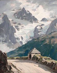
LA MEIJE BY CHARLES-HENRI CONTENCIN

http://wanderingvertexes.blogspot.com

CHARLES-HENRI CONTENCIN (1898-1955)
La Meije (3,984m - 13, 071ft)
France (Isère)

  In La Meije et  l'Oratoire du Chazelet, oil on canvas,  1946

The mountain 
La Meije (3,984m- 13, 071ft) is a mountain in the Massif des Écrins range, located at the border of the Hautes-Alpes and Isère départements. It overlooks the nearby village of La Grave, a mountaineering centre and ski resort, well known for its off-piste and extreme skiing possibilities, and also dominates the view west of the Col du Lautaret. It is the second highest mountain of the Écrins after Barre des Écrins. The central and second highest summit has five teeth, the highest of which is known as Le Doigt de Dieu (The Finger of God). This summit was reached from the northeast on June 28, 1870, by Christian and Ulrich Almer and Christian Gertsch, guiding Meta Brevoort and W.A.B. Coolidge. The ridge from the central to the main, Western peak, which is 13 meters higher, was considered an insurmountable obstacle for the next 15 years.
The Western true summit of La Meije, the Grand Pic, is notorious in that there is no "easy" path to its top and it was the last major peak in the Alps to be summited. The first ascent was eventually made from the southwest on 16 August 1877 by father and son Pierre Gaspard and their client Emmanuel Boileau de Castelnau. Their approach, over the south buttress Arête du Promontoire and further over the Glacier Carré and the southwest face of the Grand Pic is now the normal route.
On July 26, 1885, Ludwig Purtscheller and the brothers Otto and Emil Zsigmondy made the first traverse from the central to the main summit, via the "insurmountable" gap that is now known as the Brèche Zsigmondy, in what is still considered a classic route though thoroughly modified by a may 1964 rockfall. The traverse in the opposite direction was accomplished 6 years later by Ulrich Almer, Fritz Boss and J.H. Gibson.
The south face is widely considered to be the most difficult of La Meije. Within two weeks after their successful traverse, the Zsigmondy brothers, together with Karl Schulz, tried to reach the Brèche Zsigmondy over the south face, but Emil died in the attempt. The first successful attempt was not until twenty-seven years later, in 1912 by Angelo Dibona, Luigi Rizzi, and the brothers Guido and Max Mayer, while a direct route over the south face to the Grand Pic was only climbed in 1935 and that to the Central Pic in 1951.
For mountaineering, La Meije can be approached from two mountain refuges:
- The refuge du Promontoire at 3,082 metres, situated at the bottom of the steep south buttress of the peak, and allows access to routes on the south face of the mountain.
- The refuge de l'Aigle at 3,450 metres, situated at the top of the Tabuchet glacier, and allows access to the north face.

The painter 
Charles-Henri Contencin (1898-1955), is a French painter who painted many landscapes of mountain and high mountain of the great Alpine peaks, Mont Blanc and Massif and the Écrins mainly. His palette is characteristic. He particularly used the effects of sunrise or sunset over snow or glaciers.
Raised in the Bernese Oberland to the age of 10-12 years, it was a lifelong mountain lover. Good climber, he was a member of the French Alpine Club, where he made the connection with the Mountain Painters Society (SPM). He made the First World War in the infantry and he received the War Cross. He then worked in an architectural office and at the Compagnie des chemins de Fer du Nord before joining the french national railways company, the SNCF, where he was responsible for engineering structures.
In addition to his professional designs it is also author of posters and handbills for the railways under the pseudonym "Charles-Henri." He is best known for its mountain paintings and leaves an important work.

2018 - Wandering Vertexes...
by Francis Rousseau 

Monday, March 26, 2018

GROSSGLOCKNER BY HEINRICH. C. BERANN


HEINRICH C. BERANN  (1915-1999) 
Grossglockner or Glokner (3,798 m - 12,460ft)
Austria 

 In  Grossglockner poster, 1932

The mountain  
The Grossglockner (or just Glockner) (3,798 m - 12,460 ft) is above the Adriatic, the highest mountain of Austria and the highest mountain in the Alps east of the Brenner Pass. It is part of the larger Glockner Group of the Hohe Tauern range, situated along the main ridge of the Central Eastern Alps and the Alpine divide. The Pasterze, Austria's most extended glacier, lies on the Grossglockner's eastern slope. The characteristically pyramid-shaped peak actually consists of two pinnacles, the Grossglockner and the Kleinglockner (3,770 m -12,370 ft), from German: klein, "small"), separated by a saddle-like formation known as the Glocknerscharte.
The history of the climbs started with French-born natural scientist Belsazar Hacquet, from 1773 professor of anatomy at the Academy of Ljubljana. He travelled the Eastern Alps from 1779 to 1781 and published an itinerary in 1783, describing the Glokner mountain and stating that it had not been climbed yet. He estimated the mountain's height with converted (3,793 m -12,444 ft) and left an engraving illustrating Grossglockner and Pasterze, the first known depiction of the mountain.
Inspired by Hacquet's book and the first ascent of the Mont Blanc in 1786, the Gurk prince-bishop Count Franz Xaver of Salm (1749–1822) together with his vicar general Sigismund Ernst Hohenwart  (1745–1825) and Baron Franz Xaver von Wulfen (1728–1805) started efforts for a Grossglockner expedition. They engaged two peasants from Heiligenblut as mountain guides to do the first explorations for an ascent through the Leitertal valley, which is the side of Grossglockner with the least ice (people feared glaciers in these times). These valiant men, called "Glockners" in the records, did more than they were ordered to do - and probably reached the Kleinglockner summit on 23 July 1799.
One month later the bishop's expedition started: a mountain hut (the first Salm Hut) had been built and the path in the Leitertal valley was prepared so that the bishop could use a horse to reach it. 30 people, among them Salm, Hohenwart and Wulfen, were part of the expedition. They suffered with bad weather and a first effort failed, but on 25 August 1799 Hohenwart and at least four other people, including the two "Glockners", reached - again - the Kleinglockner, where they installed one of the first summit crosses (one of the main goals of the church expedition). Hohenwart's reports did not tell clearly that they had not touched the highest point but Bishop Salm (who had reached the Adlersruhe rock at 3,454 m (11,332 ft)) was informed. Dissatisfied, he invited another, even bigger expedition the next year.
On 28 July 1800, 62 people, among them the pedagogue Franz Michael Vierthaler and the botanist David Heinrich Hoppe, started again into the Leitertal valley. Four peasants and carpenters (the "Glockners" and two others who are not known) did a track in the snow, had installed fixed ropes at some steeper sections up to the end of the Glocknerleitl, and even built a second refuge, called Hohenwarte Hut. The vanguard reached the Kleinglockner peak, however, according to the expedition records by the Dellach priest Franz Joseph Horasch (Orasch), only the four guides and Mathias Hautzendorfer, the local priest of the Rangersdorf parish, were able to cross the Obere Glocknerscharte and climb the Grossglockner summit. Hautzendorfer had to be persuaded to venture the step and administered the last rites in advance.
The two "Glockners" are usually identified as the brothers Joseph (Sepp) and Martin Klotz, however, this surname is not listed in the Heiligenblut parish register. A local peasant named Sepp Hoysen is documented as a member of the second Grossglockner expedition in 1802, and the surveyor Ulrich Schiegg mentioned one Martin Reicher as "Glockner" guide. The peasants and several other members of the expedition (among them Schiegg and his young apprentice Valentin Stanič, who climbed Mt. Watzmann for the first time some weeks later) did the ascent again the next day and finally installed the summit cross and a barometer on the Grossglockner summit.
Bishop Salm undertook two more ascents in 1802 (with Hohenwart reaching the summit) and in 1806, however, he himself never climbed beyond the Adlersruhe rock. The climbing of the Grossglockner was also described by the botanist Josef August Schultes, who explored the massif together with Count Apponyi in 1802. No further ascents were made during the Napoleonic Wars, the huts decayed and were plundered by locals. In the following Vormärz era, however, the mountain became a popular venue for Alpinists like Hermann and Adolf Schlagintweit, who all followed the route of the first ascent.
By the mid 19th century, the developing Alpine tourism began to alter the traditional agriculture economy in the Heiligenblut area. Therefore, the people of Kals tried to lay out a straight ascent from the western side, which however was not reached until Julius von Payer explored the ridge between Glöcknerleitl and Ködnitzkees in 1863. Johann Stüdl had a via ferrata erected along the southwestern ridge the next year and the Stüdlhütte erected at its foot in 1868. Already in 1869, most expeditions to the summit started in Kals. The first winter ascent of the Grossglockner was made on January 2, 1875 by William Adolf Baillie Grohman, a member of the Alpine Club. In 1876 Count Pallavicini and his guide Hans Tribusser undertook the first expedition up the steep glaciated Northeast Face, chopping 2,500 steps into the Pallavicinirinne in an ice climbing master stroke not repeated for 23 years.
In 1879, Count Pallavicini dedicated a new iron summit cross on the occasion of the silver wedding of Emperor Franz Joseph of Austria and Empress Elisabeth; both had visited Heiligenblut and walked to the present-day Franz-Josefs-Höhe viewpoint in 1865. The cross was installed on 2 October 1880. Pallavicini also had the Archduke John Hut erected at the former Adlersruhe resting place of Bishop Salm, today the highest situated mountain hut in Austria. The Austrian Alpine Club built the new Salmhütte and the Glocknerhaus along the alpine route from Heiligenblut.
A first ascent by skiing was made in 1909 and the circumnavigation of the massif soon became a popular ski mountaineering tour. The Grossglockner became Austria's highest mountain, when the South Tyrolean Ortler region had to be ceded to the Kingdom of Italy according to the 1919 Treaty of Saint-Germain, which promoted its reputation as a tourist attraction.

The artist
Heinrich C. Berann, (1915–1999) the father of the modern panorama map, was born into a family of painters and sculptors in Innsbruck, Austria. He taught himself by trial and error. In the years 1930-1933 he attended the arts and design school "Bundeslehranstalt für Malerei" in Innsbruck.
Winning of first prize at a competition for a panorama map created great enthusiasm in him. Using his artistic heritage and new self-discovered techniques he invented a new way of painting landscapes for tourist purposes. The further development of both these panorama maps and his artistic style was influenced by lasting impressions he received during his military service in German Army in Norway and Northern Finland in 1942.
In 1962 he painted Mount Everest for the National Geographic Society, one of his most famous panoramic maps. He worked with Marie Tharp and Bruce C. Heezen to produce maps of the entire ocean floor in 1977.
He later created four panoramas for the United States National Park Service: Yellowstone National Park, North Cascades National Park, Yosemite National Park and finally Mt. McKinley National Park (now Denali). He was very sick when he painted Denali (above) - but he finished it in the age of 81.
In 2000, Tom Patterson of the National Park Service explored ways of digitally creating panoramas like Berann did for the Park Service.

Sunday, March 25, 2018

MOUNT DENALI MAP BY HEINRICH. C. BERANN


HEINRICH  C. BERANN (1915 - 1999) 
Mount Denali, ex Mount Mc Kinley (6,190 m - 20,310 ft)
United States of America (Alaska)

 In Denali map for US National Park Service, 1995.

The mountain 
Denali (also known as Mount McKinley, see the Naming paragraph below)) is the highest mountain peak in North America, with a summit elevation of  6,190 m - 20,310 feet above sea level. Denali is the third most prominent and third most isolated peak after Mount Everest and Aconcagua.  Denali  is one of the Seven Summit, which includes the highest mountains of each of the seven  continents. Summiting all of them is regarded as a mountaineering  challenge, first achieved on April 30, 1985 by Richard Bass.  The seven summit are :
Mount Everest (8,848m), Aconcagua (6,961m), Mt Denali or Mc Kinley (6,194m),  Kilimandjaro (5,895m), Mt Elbrus (5,642m), Vinson  Massif (4,892m), Mt Blanc (4,807m) and Mount Kosciuszko (2,228m) in Australia.
Located in the Alaska Range in the interior of the U.S. state of Alaska, Denali is the centerpiece of Denali National Park and Preserve.
Denali has two significant summits: the South Summit is the higher one, while the North Summit has an elevation of 19,470 ft (5,934 m) and a prominence of approximately 1,270 ft (387 m).  The North Summit is sometimes counted as a separate peak (see e.g., fourteener) and sometimes not; it is rarely climbed, except by those doing routes on the north side of the massif.
Five large glaciers flow off the slopes of the mountain. The Peters Glacier lies on the northwest side of the massif, while the Muldrow Glacier falls from its northeast slopes. Just to the east of the Muldrow, and abutting the eastern side of the massif, is the Traleika Glacier. The Ruth Glacier lies to the southeast of the mountain, and the Kahiltna Glacier leads up to the southwest side of the mountain.  With a length of 44 mi (71 km), the Kahiltna Glacier is the longest glacier in the Alaska Range.
The Koyukon Athabaskans who inhabit the area around the mountain have for centuries referred to the peak as Dinale or Denali. The name is based on a Koyukon word for "high" or "tall".  During the Russian ownership of Alaska, the common name for the mountain was Bolshaya Gora (Russian: Большая Гора, meaning Russian "big mountain)" which is the Russian translation of Denali.  It was briefly called Densmore's Mountain in the late 1880s and early 1890s after Frank Densmore, an Alaskan prospector who was the first European to reach the base of the mountain.
In 1896, a gold prospector named it McKinley as political support for then-presidential candidate William McKinley, who became president the following year. The United States formally recognized the name Mount McKinley after President Wilson signed the Mount McKinley National Park Act of February 26, 1917.  
In 1965, Lyndon B. Johnson declared the north and south peaks of the mountain the "Churchill Peaks", in honor of British statesman Winston Churchill.  The Alaska Board of Geographic Names changed the name of the mountain to Denali in 1975, which was how it is called locally.  However, a request in 1975 from the Alaska state legislature to the United States Board on Geographic Names to do the same at the federal level was blocked by Ohio congressman Ralph Regula, whose district included McKinley's hometown of Canton.
On August 30, 2015, just ahead of a presidential visit to Alaska, the Barack Obama administration announced the name Denali would be restored in line with the Alaska Geographic Board's designation. 

The artist
Heinrich C. Berann, (1915–1999) the father of the modern panorama map, was born into a family of painters and sculptors in Innsbruck, Austria. He taught himself by trial and error. In the years 1930-1933 he attended the arts and design school "Bundeslehranstalt für Malerei" in Innsbruck.
Winning of first prize at a competition for a panorama map created great enthusiasm in him. Using his artistic heritage and new self-discovered techniques he invented a new way of painting landscapes for tourist purposes. The further development of both these panorama maps and his artistic style was influenced by lasting impressions he received during his military service in German Army in Norway and Northern Finland in 1942.
In 1962 he painted Mount Everest for the National Geographic Society, one of his most famous panoramic maps. He worked with Marie Tharp and Bruce C. Heezen to produce maps of the entire ocean floor in 1977.
He later created four panoramas for the United States National Park Service: Yellowstone National Park, North Cascades National Park, Yosemite National Park and finally Mt. McKinley National Park (now Denali). He was very sick when he painted Denali (above) - but he finished it in the age of 81.
In 2000, Tom Patterson of the National Park Service explored ways of digitally creating panoramas like Berann did for the Park Service.

Saturday, March 24, 2018

BLUE FUJIYAMA / 富士山 BY KATSUSHIKA HOKUSAI


KATSUSHIKA HOKUSAI (1760–1849) 
Fujiyama / 富士山 (3, 776 m -12,389 ft) 
Japan

 In Blue Fuji, Musée Guimet, Paris 

About the 36 Views of Mt Fuji 
Thirty-six Views of Mount Fuji (富嶽三十六景 Fugaku Sanjūrokkei) is a series of landscape prints created by the Japanese ukiyo-e artist Hokusai (1760? - 1849).
The series depicts Mount Fuji from different locations and in various seasons and weather conditions. The original thirty-six prints were so popular that Hokusai expanded the series by ten.
The earliest impressions appear faded when compared to the versions usually seen, but are closer to Hokusai's original conception. The original prints have a deliberately uneven blue sky, which increases the sky's brightness and gives movement to the clouds. The peak is brought forward with a halo of Prussian blue. Subsequent prints have a strong, even blue tone and the printer added a new block, overprinting the white clouds on the horizon with light blue. Later prints also typically employ a strong benigara (Bengal red) pigment, which lent the painting its common name of Red Fuji. The green block colour was recut, lowering the meeting point between forest and mountain slope.

About the blue 
This intense blue that immediately strikes the visitor is the "Berlin blue" (also called Prussian blue), a pigment newly imported from Europe to Japan at the beginning of the 19th century and which has been used by Hokusai as well as  by Hiroshige.


The artist
Katsushika Hokusai (葛飾 北斎)  was a Japanese artist, ukiyo-e painter and printmaker of the Edo period. He was influenced by such painters as Sesshu, and other styles of Chinese painting. Born in Edo (now Tokyo), Hokusai is best known as author of the woodblock print series Thirty-six Views of Mount Fuji (富嶽三十六景 c. 1831) which includes the internationally recognized print, The Great Wave off Kanagawa, created during the 1820s.
Hokusai created the "Thirty-Six Views of Mt Fuji " both as a response to a domestic travel boom and as part of a personal obsession with Mount Fuji. In this series, Mt Fuji is painted on different meteorological conditions, in different hours of the days, in different seasons and from different places.

The mountain 
This is the legendary Mount Fuji or Fujiyama (富士山).
It is located on Honshu Island and is the highest mountain peak in Japan at 3,776.24 m (12,389 ft). Several names are attributed to it:  "Fuji-san", "Fujiyama" or, redundantly, "Mt. Fujiyama". Usually Japanese speakers refer to the mountain as "Fuji-san".  The other Japanese names for Mount Fuji,  have become obsolete or poetic like: Fuji-no-Yama (ふじの山 - The Mountain of Fuji), Fuji-no-Takane (ふじの高嶺- The High Peak of Fuji), Fuyō-hō (芙蓉峰 - The Lotus Peak), and Fugaku (富岳/富嶽), created by combining the first character of 富士, Fuji, and 岳, mountain.
Mount Fuji is an active stratovolcano that last erupted in 1707–08. Mount Fuji lies about 100 kilometres (60 mi) south-west of Tokyo, and can be seen from there on a clear day.
Mount Fuji's exceptionally symmetrical cone, which is snow-capped several months a year, is a well-known symbol of Japan and it is frequently depicted in art and photographs, as well as visited by sightseers and climbers.
Mount Fuji is one of Japan's Three Holy Mountains (三霊山) along with Mount Tate and Mount Haku. It is also a Special Place of Scenic Beauty and one of Japan's Historic Sites.
It was added to the World Heritage List as a Cultural Site on June 22, 2013. As per UNESCO, Mount Fuji has “inspired artists and poets and been the object of pilgrimage for centuries”. UNESCO recognizes 25 sites of cultural interest within the Mt. Fuji locality. These 25 locations include the mountain itself, Fujisan Hongū Sengen Shrine and six other Sengen shrines, two lodging houses, Lake Yamanaka, Lake Kawaguchi, the eight Oshino Hakkai hot springs, two lava tree molds, the remains of the Fuji-kō cult in the Hitoana cave, Shiraito Falls, and Miho no Matsubara pine tree grove; while on the low alps of Mount Fuji lies the Taisekiji temple complex, where the central base headquarters of Nichiren Shoshu Buddhism is located.

Friday, March 23, 2018

GUNUNG KRAKATOA 1883 ERUPTION BY PARKER & COWARD LITH.


PARKER & COWARD  LITHOGRAPH (1888)
Gunung Krakatoa (813 m - 2,667 ft) 
Indonesia (Java- Sumatra)  

 In  The eruption of Krakatoa, and subsequent phenomena.  27 May 1883, litho on paper, 
Report of the Krakatoa Committee of the Royal Society 

The volcano
Krakatoa, or Krakatau  (813 m - 2,667 ft) is a volcanic island situated in the Sunda Strait between the islands of Java and Sumatra in the Indonesian province of Lampung. The name is also used for the surrounding island group comprising the remnants of a much larger island of three volcanic peaks which was obliterated in a cataclysmic 1883 eruption. 
The most notable eruptions of Krakatoa culminated in a series of massive explosions over August 26–27, 1883, which were among the most violent volcanic events in recorded historyWith an estimated Volcanic Explosivity Index (VEI) of 6, the eruption was equivalent to 200 megatons of TNT (840 PJ)—about 13,000 times the nuclear yield of the Little Boy bomb (13 to 16 kt) that devastated Hiroshima, Japan, during World War II, and four times the yield of Tsar Bomba (50 Mt), the most powerful nuclear device ever detonated.
The 1883 eruption ejected approximately 25 km3 (6 cubic miles) of rock.  The cataclysmic explosion was heard 4,800 km (3,000 mi) away in Alice Springs, as well as on the island of Rodrigues near Mauritius, 4,653 km (2,891 mi) to the west.
According to the official records of the Dutch East Indies colony, 165 villages and towns were destroyed near Krakatoa, and 132 were seriously damaged. At least 36,417 people died, and many more thousands were injured, mostly from the tsunamis that followed the explosion. The eruption destroyed two-thirds of the island of Krakatoa.

Eruptions in the area since 1927 have built a new island at the same location, named Anak Krakatau (which is Indonesian for "Child of Krakatoa"). Periodic eruptions have continued since, with recent eruptions in 2009, 2010, 2011, and 2012. In late 2011, this island had a radius of roughly 2 kilometres (1.2 mi), and a highest point of about 324 metres (1,063 ft) above sea level,[5] growing 5 metres (16 ft) each year.[6] In 2017 the height of Anak Krakatau was reported as over 400 metres above sea level.
The previous recorded and documented eruptions were in 1680-81, 535AD, 416AD.   

Thursday, March 22, 2018

LES DENTS DU MIDI BY FERDINAND HODLER


FERDINAND HODLER (1853-1916) 
 Les Dents du Midi (3,114 m to 3,257 m -10,216 ft to10,685 ft) 
Switzerland
Painted in 1912, 1916 and 1917 

1.  In The Dents du Midi from Chesieres, 1912, oil on canvas,
2. The Dents du midi, 1916, oil on canvas  
3. Dents du Midi in clouds, 1917, Oil on canvas 

The mountain 
The Dents du Midi (Teeth of the south) (3,114 m to 3,257 m -10,216 ft to10,685 ft) are a mountain range, 3 kilometers long, located in the Chablais Alps in the canton of Valais in Switzerland. Overlooking the valley of Illiez and Rhône Valley on south, they face the lake Salanfe, an artificial reservoir, and are part of the geological whole massif Giffre.
The name "Dents du Midi" is recent. The people formerly called them "Dents Tsallen". It was only towards the end of the19e century that the name "Dents du Midi" came officially.
Each « tooth » had several names over the centuries and according to its geological evolution.
- The "Cime de l'Est" (3178 meters) called "Mont Novierre" before the mid-17th century, and "Mont Saint-Michel "after landslides in 1635 and 1636 and finally "Dent Noire" (until the 19th century).
- The "Dent Jaune" (3186 m) was called the "Dent Rouge" until 1879.
- The "Doigt de Champéry" (in 1882) and then the Doigt Salanfe (in 1886) turned just into "Les Doigts" (Fingers) (3205 m and 3210 m).
- The  "Haute Cime" (3257 m) also had many names : "Dent de l’Ouest" (until 1784)an then "Dent du Midi", "Dent de Tsallen" and "Dent de Challent."
- As for l’Eperon (3114 m) (The Spur), it is assumed that there were two peaks but a landslide in the Middle Ages significantly changed its crest.
- The Forteresse (3164 m) and the Cathedral (3160 m) have not changed names.
The evolution of this massif continues nowadays. So on the morning of 30 October 2006, a volume of 1 million m3 of rock broke away from the edge of the Haute Cime and slid down the slope to an altitude of about 3000 m. The event did not present danger to the nearby village of Val-d'Illiez but roads and trails were closed for security reasons. According to the cantonal geologist, the landslide was caused by the thawing of rocks, helped by warm summers of recent years.

The painter 
Ferdinand Hodler was one of the best-known Swiss painters of the 19th century. His early works were portraits, landscapes, and genre paintings in a realistic style. Later, he adopted a personal form of symbolism he called Parallelism.
In the last decade of the nineteenth century his work evolved to combine influences from several genres including Symbolism and Art Nouveau. In 1890 he completed Night, a work that marked Hodler's turn toward symbolist imagery. It depicts several recumbent figures, all of them relaxed in sleep except for an agitated man who is menaced by a figure shrouded in black, which Hodler intended as a symbol of death. Hodler developed a style he called "Parallelism" that emphasized the symmetry and rhythm he believed formed the basis of human society. In paintings such as The Chosen One, groupings of figures are symmetrically arranged in poses suggestive of ritual or dance.
Hodler painted number of large-scale historical paintings, often with patriotic themes. In 1897 he accepted a commission to paint a series of large frescoes for the Weapons Room of the Schweizerisches Landesmuseum in Zurich. The compositions he proposed, including The Battle of Marignan which depicted a battle that the Swiss lost, were controversial for their imagery and style, and Hodler was not permitted to execute the frescoes until 1900.
Hodler's work in his final phase took on an expressionist aspect with strongly coloured and geometrical figures. Landscapes were pared down to essentials, sometimes consisting of a jagged wedge of land between water and sky.


Wednesday, March 21, 2018

THE CATSKILLS PAINTED BY MYCHAJLO MOROZ


MYCHAJLO MOROZ  (1904-1992) 
 Catskill Mountains (1,279 m - 4,180 ft) 
 United States of America  (New York State)

 In  Catskill Mountains, 1961, oil on canvas 

The mountains 
The Catskill Mountains (1,279 m - 4,180 ft)  also known as the Catskills, are a physiographic province of the larger Appalachian Mountains, located in southeastern New York. As a cultural and geographic region, the Catskills are generally defined as those areas close to or within the borders of the Catskill Park, a 700,000-acre (2,800 km2) forest preserve forever protected from many forms of development under New York state law.
Geologically, the Catskills are a mature dissected plateau, a once-flat region subsequently uplifted and eroded into sharp relief by watercourses. The Catskills form the northeastern end of the Allegheny Plateau (also known as the Appalachian Plateau).
The Catskills are well known in American culture, both as the setting for many 19th-century Hudson River School paintings and as the favored destination for vacationers from New York City in the mid-20th century. The region's many large resorts gave countless young stand-up comedians an opportunity to hone their craft. In addition, the Catskills have long been a haven for artists, musicians, and writers, especially in and around the towns of Phoenicia and Woodstock.

The painter 
Mychajlo Moroz  is a prominent Ukrainian artist, best remembered for his landscapes painted with turbulent strokes and vivid colors.  In 1923 he became a student in the newly established Novakivskyi School of Art, where he studied until 1927. The next two years were spent studying art in Paris on a scholarship from Metropolitan Andrey Sheptytsky. In Paris, Moroz studied at the Académie Julian.
While in Paris, Moroz met such renowned Ukrainian artists as Oleksa Hryshchenko (Alexis Gritchenko), Mykola Hlushchenko and Vasyl Khmeliuk, who were also working  in variations of the expressionist style. In Paris Moroz met the famous French artist and father of the fauvist movement, Henri Matisse. The direct encounter with the Ecole de Paris, particularly the experience of French expressionists, had a strong impact on Moroz.
In 1931 Moroz traveled to Italy accompanied by his former teacher, and in 1932 he became Novakivskyi's assistant. Together they made trips to the picturesque Carpathian Mountains and were inspired to paint numerous works of the land and its people. The events of World War II and the occupation of western Ukraine by the Soviet Union interrupted Moroz's work and forced him to seek asylum for his young wife, Irena, and infant son, Ihor, in Germany.
In 1949 Moroz and his family settled in New York, where he continued to make a living as an artist. In January, 1959 he had his first of five solo exhibitions at the Panoras Gallery in New York. The journal Art News noted: "Mychajlo Moroz, a Ukrainian, is only a newcomer to New York. The unity of the show as a whole, the fluency, the fast play of brush and color, reveal an experienced painter, a man who sees his scene all of a piece, grasps its details instinctively and with a quick technique lays it out flatly and distinctly." (January 1959).
As a result of the 1962 exhibition, The New York Times wrote: "Mychajlo Moroz is showing lively interpretations of picturesque scenes, some of which tend to go beyond the picturesque to the expressionistic." (January 23, 1962).
An entire room in the Ukrainian Museum in Rome is dedicated to Moroz's work. In 1990 a retrospective exhibition of his work was held at The Ukrainian Museum in New York. The artist died in 1992 on Staten Island, N.Y.


Tuesday, March 20, 2018

MUGI HILL BY AKSELI GALLEN-KALLELA


AKSELI GALLEN-KALLELA  (1865-1931)
Mugi Hill (3,541 m - 11,617 ft)
Kenya 

In  Wakamba Plain, Mugi Hill, 1909, oil on canvas

The spot 
Mugi Hill (3,541 m - 11,617 ft ) and the Giant's Billiards Table offers some of the best hillwalking in Kenya. It  is part of the Mount Kenya National Park, established in 1949, protects the region surrounding the volcano itself.  Currently the national park is within the forest reserve which encircles it.  In April 1978 the area was designated a UNESCO Biosphere Reserve.The national park and the forest reserve, combined, became a UNESCO World Heritage Site in 1997.
The Government of Kenya had four reasons for creating a national park on and around Mount Kenya. These were the importance of tourism for the local and national economies, preserve an area of great scenic beauty, conserve the biodiversity within the park and to preserve the water catchment for the surrounding area.
Kenya’s government has announced a project to discourage animals from straying into small holdings surrounding the Park and devastating crops.  Since 2014,  the Park  is enclosed by an electric fence with five electrified strands.

The painter 
Akseli Gallen-Kallela was a Swedish-speaking Finnish painter who is best known for his illustrations of the Kalevala, the Finnish national epic. His work was considered very important for the Finnish national identity. He changed his name from Gallen to Gallen-Kallela in 1907. In 1884 he moved to Paris, to study at the Académie Julian and became friends with the Finnish painter Albert Edelfelt, the Norwegian painter Adam Dörnberger, and the Swedish writer August Strindberg.
In December 1894, Gallen-Kallela moved to Berlin to oversee the joint exhibition of his works with the works of Norwegian painter Edvard Munch. Here he became acquainted with the Symbolists.
On his return from Germany, Gallen studied print-making and visited London to deepen his knowledge, and in 1898 studied fresco-painting in Italy.
For the Paris World Fair in 1900, Gallen-Kallela painted frescoes for the Finnish Pavilion. In these frescoes, his political ideas became most apparent.Gallen-Kallela officially finnicized his name to the more Finnish-sounding Akseli Gallen-Kallela in 1907.
In 1909, Gallen-Kallela moved to Nairobi in Kenya with his family, and there he painted over 150 expressionist oil paintings and bought many east African artefacts. But he returned to Finland after a couple of years, because he realized Finland was his main inspiration. Between 1911 and 1913 he designed and built a studio and house at Tarvaspää, about 10 km northwest of the centre of Helsinki.
From December 1923 to May 1926, Gallen-Kallela lived in the United States, where an exhibition of his work toured several cities, and where he visited the Taos art-colony in New Mexico to study indigenous American art. In 1925 he began the illustrations for his "Great Kalevala". This was still unfinished when he died of pneumonia in Stockholm on 7 March 1931, while returning from a lecture in Copenhagen, Denmark
His studio and house at Tarvaspää was opened as the Gallen-Kallela Museum in 1961

Monday, March 19, 2018

THE GRINDELWALD GLACIER BY JOSEPH ANTON KOCH


JOSEPH ANTON KOCH  (1768-1839)
Grindelwald (1,034 m 3,392 ft) 
Switzerland

 In Grindelwald Glacier, 1823, oil on canvas, National Museum in Wroclaw

The spot 
Grindelwald (1,034 m 3,392 ft) designates a valley, a village and a municipality in the Interlaken-Oberhasli administrative district in the canton of Berne in Switzerland. In addition to the village of Grindelwald, the municipality also includes the settlements of Alpiglen, Burglauenen, Grund, Itramen, Mühlebach, Schwendi, Tschingelberg and Wargistal. Three major swiss peaks overlooking Grindelwald: the Eiger (3,970 m - 13, 020ft), the Mettenberg (3,104m -10,184ft), the Wetterhorn (3,692m - 12, 133ft).

The painter 
Joseph Anton Koch was an Austrian (Tyrol) painter of Neoclassicism and later the German Romantic movement; he is perhaps the most significant neoclassical landscape painter.
He   received academic training in the Karlsschule Stuttgart, a strict military academy. In 1791, he ran away, and traveled through France and Switzerland. He arrived in Rome in 1795. Koch was close to the painter Asmus Jacob Carstens and carried on Carstens' "heroic" art, at first in a literal manner. 
After 1800, Koch developed as a landscape painter.  In Rome, he espoused a new type of "heroic" landscape, revising the classical compositions of Poussin and Lorrain with a more rugged, mountainous scenery. In 1812, forced through inadequate income from his work, or in protest of the French invasion, he went to Vienna, where he worked prolifically. He stayed in Vienna until 1815. During this period, he incorporated more non-classical themes in his work.  In Vienna, he was influenced by Friedrich Schlegel and enthusiasts of old German art.  In response, his style became harsher. When returning to Rome, Koch became a conspicuous figure in the German artists' colony there.  He painted, among other works, the four frescoes in the Dante Room of the Villa Massimi (1824–29).  He wrote Moderne Kunstchronik oder die rumfordische Suppe gekocht und geschrieben von J. A. Koch (Stuttgart, 1834) which was directed humorously against unjustifiable criticism and false connoisseurship.  Koch's last years were spent in great poverty. He died in Rome,where he was buried in the Teutonic Cemetery, located next to St. Peter's Basilica within Vatican City.  He etched 20 Italian landscapes and a large sheet representing The Oath of the French at Millesimo; 14 pages after Dante, adding later another 30 pages (published Vicenza, 1904), and 36 pages after Ossian.  
He contributed American landscape scenes to the works of Alexander von Humboldt (1805).

Sunday, March 18, 2018

MOUNT SCHAFFER PAINTED BY LAWREN HARRIS


LAWREN S. HARRIS (1885-1970)
Mount Schaffer (2,962 m - 9,711 ft)
 Canada

In Mount Schaffer, Yoho national park, oil on canvas, 1926


The mountain 
Mount Schaffer (2,962 m- 9,711ft) was named in 1909 after Mary Schaffer.
Schaffer, a native of Pennsylvania, accompanied the Philadelphia Academy of Natural Sciences on a trip to the Canadian Rockies with Mary Vaux in 1889. The Rockies made an obvious impression on Mary, who was an accomplished artist, writer and photographer and she returned annually to explore until finally moving to Banff in 1912. Although Mount Schaffer overlooks one of Yoho National Park’s scenic gems: Lake O’Hara, Mary Schaffer is more well-known for her exploration of Maligne Lake in Jasper National Park. In addition to being the first tourist in Jasper National Park, in 1908, she was likely the first non-native person to see Maligne Lake since it was discovered 32 years earlier. Mount Schaffer was first climbed in 1909 by M. Goddard and W. S. Richardson.

The painter 
Lawren Stewart Harris was a leading landscape canadian painter. An inspirer of other artists, he was a key figure in the Group of Seven and gave new vision to representations of the northern Canadian landscape. During the 1920s, Harris's works became more abstract and simplified, especially his stark landscapes of the Canadian north and Arctic.  He also stopped signing and dating his works so that people would judge his works on their own merit and not by the artist or when they were painted.
In 1924, a sketching trip with A.Y. Jackson to Jasper National Park in the Canadian Rockies marked the beginning of Harris' mountain subjects, which he continued to explore with annual sketching trips until 1929, exploring areas around Banff National Park, Yoho National Park and Mount Robson Provincial Park. In 1930, Harris went on his last extended sketching trip, travelling to the Arctic aboard the supply ship SS. Beothic for two months, during which time he completed over 50 sketches.  "We are on the fringe of the great North and its living whiteness, its loneliness and replenishment, its resignations and release, tis call and answer, its cleansing rhythms. It seems that the top of the continent is a source of spiritual flow that will ever shed clarity into the growing race of America."
(Lawren S. Harris, 1926)
For Harris, art was to express spiritual values as well as to represent the visible world. North Shore, Lake Superior (1926), an image of a solitary weathered tree stump surrounded by an expanse of dramatically lit sky, effectively evokes the tension between the terrestrial and spiritual.
The resulting Arctic canvases that he developed from the oil panels marked the end of his landscape period, and from 1935 on, Harris enthusiastically embraced abstract painting. Several members of the Group of Seven later became members of the Canadian Group of Painters including Harris, A. J. Casson, Arthur Lismer, A. Y. Jackson, and Franklin Carmichael.
From 1934 to 1937, Harris lived in Hanover, New Hampshire, where he painted his first abstract works, a direction he would continue for the rest of his life. In 1938 he moved to Sante Fe, New Mexico, and helped found the Transcendental Painting Group, an organization of artists who advocated a spiritual form of abstraction.
In 1969, he was made a Companion of the Order of Canada.
Harris died in Vancouver in 1970, at the age of 84, as a well-known artist. He was buried on the grounds of the McMichael Canadian Art Collection, where his work is now held.
On November 26, 2015 his painting Mountain and Glacier was auctioned for $3.9 million at a Heffel Fine Art Auction House auction in Toronto, breaking the previous record for the sale of one of Harris's works.
In 2016 a film about Harris's life, Where the Universe Sings, was produced by TV Ontario. It was created by filmmaker Peter Raymont and directed by Nancy Lang.

Saturday, March 17, 2018

GUNUNG MERAPI BY ARTHUR ELAND


ARTHUR ELAND (1884-1948)
 Gunung Merapi or Mount Merapi (2,914m - 9,500 ft)
Indonesia (Java) 
The mountain 
Gunung Merapi (2,914m - 9,500 ft)  is an active stratovolcano located on the border between Central Java and Yogyakarta, Indonesia. It is the most active volcano in Indonesia and has erupted regularly since 1548. It is located approximately 28 kilometres (17 mi) north of Yogyakarta city which has a population of 2.4 million, and thousands of people live on the flanks of the volcano, with villages as high as 1,700 metres (5,600 ft) above sea level.
Smoke can often be seen emerging from the mountaintop, and several eruptions have caused fatalities. Pyroclastic flow from a large explosion killed 27 people on 22 November 1994, mostly in the town of Muntilan, west of the volcano.Another large eruption occurred in 2006, shortly before the Yogyakarta earthquake. In light of the hazards that Merapi poses to populated areas, it has been designated as one of the Decade Volcanoes.
On 25 October 2010 the Indonesian government raised the alert for Mount Merapi to its highest level and warned villagers in threatened areas to move to safer ground. People living within a 20 km (12 mi) zone were told to evacuate. Officials said about 500 volcanic earthquakes had been recorded on the mountain over the weekend of 23–24 October, and that the magma had risen to about 1 kilometre (3,300 ft) below the surface due to the seismic activity. On the afternoon of 25 October 2010 Mount Merapi erupted lava from its southern and southeastern slopes.
The mountain was still erupting on 30 November 2010, but due to lowered eruptive activity on 3 December 2010 the official alert status was reduced to level 3. The volcano is now 2930 metres high, 38 metres lower than before the 2010 eruptions.
After a large eruption in 2010 the characteristic of Mount Merapi was changed. On 18 November 2013 Mount Merapi burst smoke up to 2,000 meters high, one of its first major phreatic eruptions after the 2010 eruption. Researchers said that this eruption occurred due to combined effect of hot volcanic gases and abundant rainfall.
In 2004 an area of 6,410 hectares around Mount Merapi was established as a national park. The decision of the Ministry of Forestry to declare the park has been subsequently challenged in court by The Indonesian Forum for Environment, on grounds of lack of consultation with local residents. During the 2006 eruption of the volcano it was reported that many residents were reluctant to leave because they feared their residences would be confiscated for expansion of the national park, meaning they wouldn't have a house.
Mythology
Merapi is very important to Javanese, especially those living around its crater. As such, there are many myths and beliefs attached to Merapi. It is believed that when the gods had just created the Earth, Java was unbalanced because of the placement of Mount Jamurdipo on the west end of the island. In order to assure balance, the gods (generally represented by Batara Guru) ordered the mountain to be moved to the centre of Java. However, two armourers, Empu Rama and Empu Permadi, were already forging a sacred keris at the site where Mount Jamurdipo was to be moved. The gods warned them that they would be moving a mountain there, and that they should leave; Empu Rama and Empu Permadi ignored that warning. In anger, the gods buried Empu Rama and Empu Permadi under Mount Jamurdipo; their spirits later became the rulers of all mystical beings in the area. In memory of them, Mount Jamurdipo was later renamed Mount Merapi, which means "fire of Rama and Permadi.
The Javanese believe that the Earth is not only populated by human beings, but also by spirits (makhluk halus). Villages near Merapi believe that one of the palaces (in Javanese kraton) used by the rulers of the spirit kingdom lies inside Merapi, ruled by Empu Rama and Empu Permadi. This palace is said to be a spiritual counterpart to the Yogyakarta Sultanate, complete with roads, soldiers, princes, vehicles, and domesticated animals. Besides the rulers, the palace is said to also be populated by the spirits of ancestors who died as righteous people. The spirits of these ancestors are said to live in the palace as royal servants (abdi dalem), occasionally visiting their descendants in dreams to give prophecies or warnings. "
Spirits of Merapi
To keep the volcano quiet and to appease the spirits of the mountain, the Javanese regularly bring offerings on the anniversary of the sultan of Yogyakarta's coronation. For Yogyakarta Sultanate, Merapi holds significant cosmological symbolism, because it is forming a sacred north-south axis line between Merapi peak and Southern Ocean (Indian Ocean). The sacred axis is signified by Merapi peak in the north, the Tugu Yogyakarta (id) monument near Yogyakarta main train station, the axis runs along Malioboro street to Northern Alun-alun (square) across Keraton Yogyakarta (sultan palace), Southern Alun-alun, all the way to Bantul and finally reach Samas and Parangkusumo beach on the estuary of Opak river and Southern Ocean. This sacred axis connected the hyangs or spirits of mountain revered since ancient times—often identified as "Mbah Petruk" by Javanese people—The Sultan of Yogyakarta as the leader of the Javanese kingdom, and Nyi Roro Kidul as the queen of the Southern Ocean, the female ocean deity revered by Javanese people and also mythical consort of Javanese kings.

The painter 
There is not much biographical information about Arthur Eland, except that he was Leo Eland's twin brother. These two Dutch  brothers were born in 1884 in the Dutch East Indies on Java in Salatiga. After the death of Arthur and since the 1970s many of his canvases and watercolors representing large Indonesian volcanic landscapes have gone into auctions especially at Christie's and have acquired unmistakable market value. Christie's classified him after the colonial impressionist painters

Friday, March 16, 2018

Y LLIWEDD BY SIR KYFFIN WILLIAMS


SIR KYFFIN WILLIAMS (1918-2006) 
Y Lliwedd  (898m- 2, 946ft)
 United Kingdom (Wales)

In Sun and Cloud on Lliwedd, oil on canvas, 1973  
Aberystwyth University School of Art Museum and Galleries 

The mountain 
Y Lliwedd  (898m- 2, 946ft) is a mountain, connected to Mount Snowdon  in the Snowdonia National Park, North Wales. The eastern flanks are steep cliffs rising above Glaslyn and Llyn Llydaw. Y Lliwedd is the most conspicuous of the peaks for those who approach Snowdon via the Miners' and Pyg tracks. Few that summit Snowdon continue over to Y Lliwedd as the challenge of Wales' highest peak is enough, leaving Y Lliwedd quiet and peaceful even when queues are forming at the summit of Snowdon.
Hikers and mountaineers often pass over Y Lliwedd when walking the Snowdon Horseshoe. The noted British climber George Mallory undertook many of his early climbs here. It was also the site of considerable training activity for the 1953 British Everest Expedition.
The north face of Y Lliwedd was explored in the late 19th century and in 1909 was the subject of the first British climbing guide, The climbs on Lliwedd by J. M. A. Thomson and A. W. Andrews.
Two subsidiary peaks of Y Lliwedd are listed as Nuttalls: Lliwedd Bach (818m - 2,699 ft)  and Y Lliwedd East Peak  (893m- 2,947ft)

The Painter 
Sir John "Kyffin" Williams, KBE, RA was a Welsh landscape painter who lived at Pwllfanogl, Llanfairpwll, on the Island of Anglesey. Williams is widely regarded as the defining artist of Wales during the 20th century.
His works typically drew inspiration from the Welsh landscape and farmlands. His works may be seen in a permanent exhibition in the Oriel Kyffin Williams Gallery which opened in 2008 at Oriel Ynys Môn in Llangefni, Anglesey, as well as at many other galleries elsewhere in Britain. He was president of the Royal Cambrian Academy and was appointed a member of the Royal Academy in 1974.
In 1995 Williams received the Glyndŵr Award for an Outstanding Contribution to the Arts in Wales during the Machynlleth Festival. He was awarded the OBE for his services to the arts in 1982 and a KBE in 1999.
The Kyffin Williams Drawing Prize was established in 2009. The winning works from the 2018 prize are due to be exhibited at the Oriel Kyffin Williams Gallery.
In February 2011 it was announced that Williams' paintings of Patagonia would be shown for the first time.  His last passport, on show in the Oriel Ynys Môn gallery at Llangefni, 2004–2014, has the name Sir John Williams. Kyffin was his grandmother's maiden name.
Williams' works are held in many public collections, including the Government Art Collection, the Arts Council Collection and the National Museum of Wales.

Thursday, March 15, 2018

SIF MONS BY NASA MAGELLAN MISSION


NASA MAGELLAN MISSION (1989-1994)
Sif Mons (2,000m / 2kms- 6561ft / 1, 24mi) 
Venus 

The volcano 
Sif Mons is a shield volcano located on the planet Venus at 22 ° N and 352.4 ° E, in the west of Eistla Regio. It is south of Sedna Planitia, west of Bereghinya Planitia and east of Guinevere Planitia. It is near Gula Mons, a little bigger and located further east in the extension of Eistla. Its lava flows are clearly visible even from Earth using the Arecibo radio telescope. The volcano is named after Sif, the northern goddess.

The photo
Sif Mons is displayed in this computer-simulated view of the surface of Venus. The viewpoint is located 360 kilometers (223 miles) north of Sif Mons at a height of 7.5 kilometers (4.7 miles) above the lava flows. Lave flows extend for hundreds of kilometers across the fractured plains shown in the foreground to the base of Sif Mons. The view is to the south. Sif Mons, a volcano with a diameter of 300 kilometers (186 miles) and a height of 2 kilometers (1.2 miles), appears in the upper half of the image. Magellan synthetic aperture radar data is combined with radar altimetry to produce a three-dimensional map of the surface. Rays, cast in a computer, intersect the surface to create a three-dimensional perspective view. Simulated color and a digital elevation map developed by the U.S. Geological Survey are used to enhance small-scale structure. The simulated hues are based on color images recorded by the Soviet Venera 13 and 14 spacecraft. The image was produced at the JPL Multimission Image Processing Laboratory and is a single frame from a video released at the March 5, 1991, JPL news conference.

Wednesday, March 14, 2018

BEN NEVIS BY CECIL ARTHUR HUNT


CECIL ARTHUR HUNT (1873-1965)
Ben Nevis (1,344 m - 4, 118 ft)
Great Britain - Scotland
The mountain 
Ben Nevis  (1,344 m - 4, 118 ft)  in Scottish Gaelic: Beinn Nibheis is the highest mountain in the British Isles, located in Scotland, at the western end of the Grampian Mountains in the Lochaber area of the Scottish Highlands, close to the town of Fort William.
The mountain is a popular destination, attracting an estimated 100,000 ascents a year, around three-quarters of which use the Pony Track from Glen Nevis. The 700m  (2,300 ft) cliffs of the north face are among the highest in Scotland, providing classic scrambles and rock climbs of all difficulties for climbers and mountaineers. They are also the principal locations in Scotland for ice climbing.
The summit, which is the collapsed dome of an ancient volcano, features the ruins of an observatory which was continuously staffed between 1883 and 1904. The meteorological data collected during this period are still important for understanding Scottish mountain weather. C. T. R. Wilson was inspired to invent the cloud chamber after a period spent working at the observatory.
The first recorded ascent of Ben Nevis was made on 17 August 1771 by James Robertson, an Edinburgh botanist, who was in the region to collect botanical specimens. Another early ascent was in 1774 by John Williams, who provided the first account of the mountain's geological structure. John Keats climbed the mountain in 1818, comparing the ascent to "mounting ten St. Pauls without the convenience of a staircase".  The following year William MacGillivray, who was later to become a distinguished naturalist, reached the summit only to find "fragments of earthen and glass ware, chicken bones, corks, and bits of paper"
It was not until 1847 that Ben Nevis was confirmed by the Ordnance Survey as the highest mountain in Britain and Ireland, ahead of its rival Ben Macdhui.
In 2000, the Ben Nevis Estate, comprising all of the south side of the mountain including the summit, was bought by the Scottish conservation charity the John Muir Trust.

The painter 
Cecil Arthur Hunt was educated at Winchester and Trinity College, Cambridge, studying Classics and Law, and being called to the Bar in 1899. He treated painting and writing as serious pastimes until 1925, when he was elected to the full membership of the Royal Society of Painters in Water-Colours. He then relinquished his legal career to become a professional painter.
Hunt had first exhibited in 1900, at the Alpine Club Galleries, and had held his first major show a year later, alongside E Home Bruce at the Ryder Gallery. From the first, he established himself as an atmospheric painter of mountains, especially of the Alps and Dolomites. However, he was soon accepted as a master of a great variety of topographies, for he exhibited the products of his wide travels frequently and extensively. Favourite destinations included the West Country, the West Coast of Scotland, the Rhone Valley, Northern Italy, Rome and Taormina. From 1911, until his death, Hunt lived at Mallord House in Chelsea, especially designed for him by Sir Ralph Knott to include a large studio on the ground floor. During the summer months he and his family retreated to the farm estate of Foxworthy, on the edge of Dartmoor.
Hunt showed work regularly at the Royal Academy (from 1912), the Royal Society of British Artists (from 1914) and the Royal Society of Painters in Water-Colours (from 1918). He was elected a member of the RBA in 1914, an associate of the RWS in 1919, and a full member six years later. He acted as the Vice-President of the RWS for a three-year period from 1930. His many substantial solo shows included six at the Fine Art Society (1919-34) and one at Colnaghi’s (1945). Following his death, in 1965,  he was the subject of a large memorial show at the Royal Society of Painters in Water-Colours.
Chris Beetles has done much to revive interest in the work of Cecil Arthur Hunt. He mounted a large scale retrospective exhibition in 1996 at his London gallery, on the exact site of the artist’s first substantial show in 1901. The retrospective was accompanied by a definitive catalogue.