google.com, pub-0288379932320714, DIRECT, f08c47fec0942fa0 GRAVIR LES MONTAGNES... EN PEINTURE: Mount Tarawera
Showing posts with label Mount Tarawera. Show all posts

Sunday, January 9, 2022

MOUNT TARAWERA (2) PAINTED BY CHARLES BLOMFIELD


CHARLES BLOMFIELD (1848-1926) Mount Tarawera (1, 111m - 3,645ft)  New Zealand (North Island)    In  White Terraces, oil on canvas, 1882, Museum of New Zeland Te Papa Tongarewa

CHARLES BLOMFIELD (1848-1926)
Mount Tarawera (1, 111m - 3,645ft) 
New Zealand (North Island)

  In  White Terraces, oil on canvas, 1882, Museum of New Zeland Te Papa Tongarewa 

The full extraordinsary story  of this unbelievable volcano  in paintings is HERE


The mountain 
Mount Tarawera (1, 111m - 3,645ft) is the volcano responsible for one of New Zealand's largest historic eruptions. Located 24 kilometres southeast of Rotorua in the North Island, it consists of a series of rhyolitic lava domes that were fissured down the middle by an explosive basaltic eruption in 1886, which killed an estimated 120 people. These fissures run for about 17 kilometres northeast-southwest.
The volcano's component domes include Ruawahia Dome, Tarawera Dome and Wahanga Dome. It is surrounded by several lakes, most of which were created or drastically altered by the 1886 eruption. These lakes include Lakes Tarawera, Rotomahana, Rerewhakaaitu, Okataina, Okareka, Tikitapu (Blue Lake) and Rotokakahi (Green Lake). The Tarawera River runs northeastwards across the northern flank of the mountain from Lake Tarawera.
Main eruptions 
- 1315 : Mount Tarawera erupted for the fist time on modern history. The ash thrown from this event may have affected temperatures around the globe and precipitated the Great Famine of 1315–17 in Europe.
- 1886 : Shortly after midnight on the morning of 10 June 1886, a series of more than 30 increasingly strong earthquakes were felt in the Rotorua area and an unusual sheet lightning display was observed from the direction of Tarawera. At around 2:00 am a larger earthquake was felt and followed by the sound of an explosion. By 2:30 am Mount Tarawera's three peaks had erupted, blasting three distinct columns of smoke and ash thousands of metres into the sky (see painting above). At around 3.30 am, the largest phase of the eruption commenced; vents at Rotomahana produced a pyroclastic surge that destroyed several villages within a 6 kilometre radius, and the Pink and White Terraces appeared to be obliterated.
The eruption was heard clearly as far away as Blenheim and the effects of the ash in the air were observed as far south as Christchurch, over 800 km away. In Auckland the sound of the eruption and the flashing sky was thought by some to be an attack by Russian warships.
Although the official contemporary death toll was 153, exhaustive research by physicist Ron Keam only identified 108 people killed by the eruption. Much of the discrepancy was due to misspelled names and other duplications. Allowing for some unnamed and unknown victims, he estimated that the true death toll was 120 at most.  Some people claim that many more people died.
The eruption also buried many Māori villages, including Te Wairoa which has now become a tourist attraction (Buried Village of Te Wairoa) and the world-famous Pink and White Terraces were lost. A small portion of the Pink Terraces was rediscovered under Lake Rotomahana 125 years later. Approximately 2 cubic kilometres of tephra was erupted, more than Mount St. Helens ejected in 1980. Many of the lakes surrounding the mountain had their shapes and areas dramatically altered, especially the eventual enlargement of Lake Rotomahana, the largest crater involved in the eruption, as it re-filled with water.
Legend
One legend surrounding the 1886 eruption is that of the phantom canoe. Eleven days before the eruption, a boat full of tourists returning from the Terraces saw what appeared to be a war canoe approach their boat, only to disappear in the mist half a mile from them. One of the witnesses was a clergyman, a local Maori man from the Te Arawa iwi. Nobody around the lake owned such a war canoe, and nothing like it had been seen on the lake for many years. It is possible that the rise and fall of the lake level caused by pre eruption fissures had freed a burial waka (canoe) from its resting place. Traditionally dead chiefs were tied in an upright position. A number of letters have been published from the tourists who experienced the event.
Though skeptics maintained that it was a freak reflection seen on the mist, tribal elders at Te Wairoa claimed that it was a waka wairua (spirit canoe) and was a portent of doom. It has been suggested that the waka was actually a freak wave on the water, caused by seismic activity below the lake, but locals believe that a future eruption will be signaled by the reappearance of the canoe.


The painter 
 Charles Blomfield  was a New Zealand decorator, artist and music teacher born in London, England.
A widow, Blomfield's mother brought her family to New Zealand in the 1860's intending to settle in Northland as part of a settlement called Albertland. On arrival in Auckland they decided not to proceed on Northland to become farmers but to pursue urban trades in Auckland. The family remained in Auckland after that and many of the descendants of the various children still reside in the Auckland area.
Charles Blomfield lived in Freeman's Bay - 40 Wood Street, in a house built by his brother and allegedly made out of the timber from one large Kauri tree. As well as an exhibiting easel painter Blomfield worked as a sign-writer and interior decorator; for this trade he maintained studios in shops at various times. These were usually on Karangahape Road, one of these was shared with his daughter who made a living painting floral pieces which she also exhibited at the Auckland Society of Arts.
Blomfield travelled throughout the centre of the North Island on several occasions in the 1870s and 80s creating many landscape paintings of the New Zealand countryside, often for sale to visitors to New Zealand. He was fortunate to view the famed Pink and White Terraces several times and paint them before they were destroyed by the eruption of Tarawera in 1886. His meticulous sketches and finished paintings are some of the main records of them (see above).  For the remainder of his life he was probably able to rely on new versions of his classic views of them to supplement his income.
His paintings are widely regarded as the epitome of 19th century New Zealand landscape art, although his work, like many of his contemporaries, fell out of fashion during the 20th century, only to be re-evaluated in the 1970s. He was unable to come to terms with developments in art and remained staunchly conservative and hostile to 'modern art'. In his later years he found himself increasingly sidelined by the artistic circles in Auckland which he had previously shone in and was probably embittered by this.
Blomfield died at his residence in Wood Street in 1926. He was survived by several children. One of his brothers, William, was a noted newspaper cartoonist.
 Source : 
 
 _____________________________________
2022 - Wandering Vertexes...
Un blog de Francis Rousseau 

Wednesday, August 4, 2021

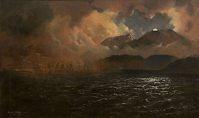
MOUNT TARAWERA AND LAKE PAINTED BY KENNETT WATKINS

KENNETT WATKINS (1847-1933), Mount Tarawera (1, 111m - 3,645ft), New Zealand (North Island),  In  "The Phantom Canoe - A Legend of Lake Tarawera  ", oil on canvas, Auckland Art Gallery


KENNETT WATKINS (1847-1933)
Mount Tarawera (1, 111m - 3,645ft)
New Zealand (North Island)

In The Phantom Canoe - A Legend of Lake Tarawera , oil on canvas Auckland Art Gallery


The Legend
One legend surrounding the 1886 eruption  of Mount Tarawera is that of the phantom canoe. Eleven days before the eruption, a boat full of tourists returning from the Terraces saw what appeared to be a war canoe approach their boat, only to disappear in the mist half a mile from them. One of the witnesses was a clergyman, a local Maori man from the Te Arawa iwi. Nobody around the lake owned such a war canoe, and nothing like it had been seen on the lake for many years. It is possible that the rise and fall of the lake level caused by pre eruption fissures had freed a burial waka (canoe) from its resting place. Traditionally dead chiefs were tied in an upright position. A number of letters have been published from the tourists who experienced the event.
Though skeptics maintained that it was a freak reflection seen on the mist, tribal elders at Te Wairoa claimed that it was a waka wairua (spirit canoe) and was a portent of doom. It has been suggested that the waka was actually a freak wave on the water, caused by seismic activity below the lake, but locals believe that a future eruption will be signaled by the reappearance of the canoe.

 
The mountain  and the lake
Mount Tarawera (1, 111m - 3,645ft) is the volcano responsible for one of New Zealand's largest historic eruptions. Located 24 kilometres southeast of Rotorua in the North Island, it consists of a series of rhyolitic lava domes that were fissured down the middle by an explosive basaltic eruption in 1886, which killed an estimated 120 people. These fissures run for about 17 kilometres northeast-southwest.
The volcano's component domes include Ruawahia Dome, Tarawera Dome and Wahanga Dome. It is surrounded by several lakes, most of which were created or drastically altered by the 1886 eruption. These lakes include Lakes Tarawera, Rotomahana, Rerewhakaaitu, Okataina, Okareka, Tikitapu (Blue Lake) and Rotokakahi (Green Lake). The Tarawera River runs northeastwards across the northern flank of the mountain from Lake Tarawera.
Main eruptions
- 1315 : Mount Tarawera erupted for the fist time on modern history. The ash thrown from this event may have affected temperatures around the globe and precipitated the Great Famine of 1315–17 in Europe.
- 1886 : Shortly after midnight on the morning of 10 June 1886, a series of more than 30 increasingly strong earthquakes were felt in the Rotorua area and an unusual sheet lightning display was observed from the direction of Tarawera. At around 2:00 am a larger earthquake was felt and followed by the sound of an explosion. By 2:30 am Mount Tarawera's three peaks had erupted, blasting three distinct columns of smoke and ash thousands of metres into the sky (see painting above). At around 3.30 am, the largest phase of the eruption commenced; vents at Rotomahana produced a pyroclastic surge that destroyed several villages within a 6 kilometre radius, and the Pink and White Terraces appeared to be obliterated.
The eruption was heard clearly as far away as Blenheim and the effects of the ash in the air were observed as far south as Christchurch, over 800 km away. In Auckland the sound of the eruption and the flashing sky was thought by some to be an attack by Russian warships.
Although the official contemporary death toll was 153, exhaustive research by physicist Ron Keam only identified 108 people killed by the eruption. Much of the discrepancy was due to misspelled names and other duplications. Allowing for some unnamed and unknown victims, he estimated that the true death toll was 120 at most. Some people claim that many more people died.
The eruption also buried many Māori villages, including Te Wairoa which has now become a tourist attraction (Buried Village of Te Wairoa) and the world-famous Pink and White Terraces were lost. A small portion of the Pink Terraces was rediscovered under Lake Rotomahana 125 years later. Approximately 2 cubic kilometres of tephra was erupted, more than Mount St. Helens ejected in 1980. Many of the lakes surrounding the mountain had their shapes and areas dramatically altered, especially the eventual enlargement of Lake Rotomahana, the largest crater involved in the eruption, as it re-filled with water. 

The painter
Kennett Watkins was born in India in 1847, the son of Major John Watkins and Martha Jane Simons; he was Christened on 21 July 1847 in Ootacamund, Madras, India. His father died some time before 1861. In the UK Census of 1861 he was recorded in the household of his widowed grandmother Sarah Simons at 59 Marine Parade, Brighton, Sussex, England. Aged 13 and a scholar. Also in the household was his widowed mother Martha, his three siblings Lydia, Edward and John, 23 year old cousin Lieut. William Ker and two servants. He was educated in England and, as an artist, in France and Switzerland.
Kennett Watkins migrated from England to New Zealand. He emigrated from England to New Zealand in 1873, where he married Clara Eliza Alice Davis in 1876.
He was a photographer, painter of lndscapes (oil and waterolors) and teacher in Auckland.
He passed away in 1933 at age 86 and was buried in the Mercury Bay Cemetery in Thames-Coromandel District, Waikato, New Zealand.
The earliest auction registered for Kenneth Watkins pianitngs is in1992 for a toal 57 worksoffered for sale of which 29 ( 51%) weresold. The highest price recorded wis $ 136,450 for Maro family Canoeing on the Waokato River.

Sunday, January 19, 2020

MOUNT TARAWERA / PINK TERRACES PHOTOGRAPHED BY CHARLES SPENCER


CHARLES SPENCER (1854-1933)
Mount Tarawera / Pink and White Terraces  (1, 111m - 3,645ft) 
 New Zealand

 In Pink Terraces- c.1900, black and white phototgraphs hand colored, 
Museum of New Zealand / Te Papa Tongarewa


The volcano and the terraces
On 10 June 1886, Mount Tarawera  (1, 111m - 3,645ft) erupted. The eruption spread from west of Wahanga dome, 5 kilometres (3.1 mi) to the north, down to Lake Rotomahana. The volcano belched out hot mud, red hot boulders, and immense clouds of black ash from a 17 kilometres (11 mi) rift that crossed the mountain, passed through the lake, and extended beyond into the Waimangu valley.
After the eruption, a crater over 100 metres (330 ft) in depth encompassed the former site of the terraces.  After some years this filled with water to form a new Lake Rotomahana, 30–40 metres (98–131 ft) higher, ten times larger and deeper than the old lake.  This  explosive basaltic eruption  killed an estimated 120 people.
Alfred Patchet Warbrick, a boat builder at Te Wairoa, witnessed the eruption of Mount Tarawera from Maunga Makatiti to the north of Lake Tarawera. Warbrick soon had whaleboats on Lake Tarawera investigating the new landscape; he in time became the chief guide to the post-eruption attractions. Warbrick never accepted that the Pink and White Terraces had been destroyed

The photographer
When Tarawera erupted only a few weeks later, Geological Survey director James Hector and assistant geologist James Park disembarked at Tauranga on 12 June, en route to the Rotorua lakes district to report on the disturbance. He immediately engaged Charles Spencer who was already a famous photograph in new Zealand, to accompany the party and record the effects of the eruption.
By the time Spencer returned to Tauranga a week later he had accumulated an initial set of plates which he developed and printed. He then returned to Te Wairoa on 8 July and took several more views during a brief spell of decent weather. At the end of the month he made a third visit, accompanying Percy Smith’s surveying party for almost a week, and taking a number of views between the Ruawahia Dome on Tarawera and the craters to the south-west near Rotomahana.
Although no definitive lists exist, it is likely that Spencer produced several dozen views of the Rotorua hot lakes district before and after the eruption, and as a result his are some of the better known images, in collections throughout the world.

__________________________________

2020 - Wandering Vertexes...
by Francis Rousseau


Tuesday, August 20, 2019

MOUNT TARAWERA / PINK TERRACES BY JOHN BARR CLARK HOYTE

https://wanderingvertexes.blogspot.com/2019/08/john-barr-clark-hoyte-1835-1913-mount.html


JOHN BARR CLARK HOYTE (1835-1913)
Mount Tarawera (1, 111m - 3,645ft) 
New Zealand

In Mount Tarawera with Maori Figures Camping in the Foreground, oil on canvas

The mountain
Mount Tarawera (1, 111m - 3,645ft) is the volcano responsible for one of New Zealand's largest historic eruptions. Located 24 kilometres southeast of Rotorua in the North Island, it consists of a series of rhyolitic lava domes that were fissured down the middle by an explosive basaltic eruption in 1886, which killed an estimated 120 people. These fissures run for about 17 kilometres northeast-southwest.
The volcano's component domes include Ruawahia Dome, Tarawera Dome and Wahanga Dome. It is surrounded by several lakes, most of which were created or drastically altered by the 1886 eruption. These lakes include Lakes Tarawera, Rotomahana, Rerewhakaaitu, Okataina, Okareka, Tikitapu (Blue Lake) and Rotokakahi (Green Lake). The Tarawera River runs northeastwards across the northern flank of the mountain from Lake Tarawera.
One legend surrounding the 1886 eruption is that of the phantom canoe. Eleven days before the eruption, a boat full of tourists returning from the Terraces saw what appeared to be a war canoe approach their boat, only to disappear in the mist half a mile from them. One of the witnesses was a clergyman, a local Maori man from the Te Arawa iwi. Nobody around the lake owned such a war canoe, and nothing like it had been seen on the lake for many years. It is possible that the rise and fall of the lake level caused by pre eruption fissures had freed a burial waka (canoe) from its resting place. Traditionally dead chiefs were tied in an upright position. A number of letters have been published from the tourists who experienced the event.
Though skeptics maintained that it was a freak reflection seen on the mist, tribal elders at Te Wairoa claimed that it was a waka wairua (spirit canoe) and was a portent of doom. It has been suggested that the waka was actually a freak wave on the water, caused by seismic activity below the lake, but locals believe that a future eruption will be signaled by the reappearance of the canoe.

The Painter
John Barr Clark Hoyte was born in England, probably in London, Nothing is known of Hoyte's education and artistic training and we are reduced to the obvious deduction that he was heir to the English tradition of topographic draughtsmanship and watercolour painting. Firm drawing underlies his landscapes, making it appropriate to group him with colonial surveyor–architect artists such as Edward Ashworth, Edmund Norman and George O'Brien.
During his years in New Zealand John Hoyte travelled assiduously in search of new scenes to exploit. His pictorial exploration of the colony's principal dramatic landscapes was completed when he took a cruise circumnavigating the South Island in early 1877, exploring the coast of Fiordland with particular attention. New Zealand subjects would continue to inspire his production long after he had settled in Australia, where they shared his attention with coastal and mountain views drawn chiefly from the neighbourhood of Sydney.
Despite his apparent commercial success, however, Hoyte's standing, like that of George O'Brien, waned in the 1870s: a decade which marked a major shift in New Zealand colonial taste as the Turnerian Romantics such as Gully, J. C. Richmond and W. M. Hodgkins moved into greater prominence. They and their style were to dominate the following decades.
__________________________________________

2019 - Wandering Vertexes...
by Francis Rousseau

Saturday, February 2, 2019

MOUNT TARAWERA / PINK TERRACES BY JOHN BARR CLARK HOYTE


JOHN BARR CLARK HOYTE (1835-1913)
Mount Tarawera (1, 111m - 3,645ft) 
 New Zealand

In The pink terraces, Mount Tarawera, oil on canvas


The mountain 
Mount Tarawera (1, 111m - 3,645ft) is the volcano responsible for one of New Zealand's largest historic eruptions. Located 24 kilometres southeast of Rotorua in the North Island, it consists of a series of rhyolitic lava domes that were fissured down the middle by an explosive basaltic eruption in 1886, which killed an estimated 120 people. These fissures run for about 17 kilometres northeast-southwest.
The volcano's component domes include Ruawahia Dome, Tarawera Dome and Wahanga Dome. It is surrounded by several lakes, most of which were created or drastically altered by the 1886 eruption. These lakes include Lakes Tarawera, Rotomahana, Rerewhakaaitu, Okataina, Okareka, Tikitapu (Blue Lake) and Rotokakahi (Green Lake). The Tarawera River runs northeastwards across the northern flank of the mountain from Lake Tarawera.
Main eruptions 
- 1315 : Mount Tarawera erupted for the fist time on modern history. The ash thrown from this event may have affected temperatures around the globe and precipitated the Great Famine of 1315–17 in Europe.
- 1886 : Shortly after midnight on the morning of 10 June 1886, a series of more than 30 increasingly strong earthquakes were felt in the Rotorua area and an unusual sheet lightning display was observed from the direction of Tarawera. At around 2:00 am a larger earthquake was felt and followed by the sound of an explosion. By 2:30 am Mount Tarawera's three peaks had erupted, blasting three distinct columns of smoke and ash thousands of metres into the sky (see painting above). At around 3.30 am, the largest phase of the eruption commenced; vents at Rotomahana produced a pyroclastic surge that destroyed several villages within a 6 kilometre radius, and the Pink and White Terraces appeared to be obliterated.
The eruption was heard clearly as far away as Blenheim and the effects of the ash in the air were observed as far south as Christchurch, over 800 km away. In Auckland the sound of the eruption and the flashing sky was thought by some to be an attack by Russian warships.
Although the official contemporary death toll was 153, exhaustive research by physicist Ron Keam only identified 108 people killed by the eruption. Much of the discrepancy was due to misspelled names and other duplications. Allowing for some unnamed and unknown victims, he estimated that the true death toll was 120 at most.  Some people claim that many more people died.
The eruption also buried many Māori villages, including Te Wairoa which has now become a tourist attraction (Buried Village of Te Wairoa) and the world-famous Pink and White Terraces were lost. A small portion of the Pink Terraces was rediscovered under Lake Rotomahana 125 years later. Approximately 2 cubic kilometres of tephra was erupted, more than Mount St. Helens ejected in 1980. Many of the lakes surrounding the mountain had their shapes and areas dramatically altered, especially the eventual enlargement of Lake Rotomahana, the largest crater involved in the eruption, as it re-filled with water.
Legend
One legend surrounding the 1886 eruption is that of the phantom canoe. Eleven days before the eruption, a boat full of tourists returning from the Terraces saw what appeared to be a war canoe approach their boat, only to disappear in the mist half a mile from them. One of the witnesses was a clergyman, a local Maori man from the Te Arawa iwi. Nobody around the lake owned such a war canoe, and nothing like it had been seen on the lake for many years. It is possible that the rise and fall of the lake level caused by pre eruption fissures had freed a burial waka (canoe) from its resting place. Traditionally dead chiefs were tied in an upright position. A number of letters have been published from the tourists who experienced the event.
Though skeptics maintained that it was a freak reflection seen on the mist, tribal elders at Te Wairoa claimed that it was a waka wairua (spirit canoe) and was a portent of doom. It has been suggested that the waka was actually a freak wave on the water, caused by seismic activity below the lake, but locals believe that a future eruption will be signaled by the reappearance of the canoe.

The Painter 
John Barr Clark Hoyte was born in England, probably in London,  Nothing is known of Hoyte's education and artistic training and we are reduced to the obvious deduction that he was heir to the English tradition of topographic draughtsmanship and watercolour painting. Firm drawing underlies his landscapes, making it appropriate to group him with colonial surveyor–architect artists such as Edward Ashworth, Edmund Norman and George O'Brien.
During his years in New Zealand John Hoyte travelled assiduously in search of new scenes to exploit.   His pictorial exploration of the colony's principal dramatic landscapes was completed when he took a cruise circumnavigating the South Island in early 1877, exploring the coast of Fiordland with particular attention. New Zealand subjects would continue to inspire his production long after he had settled in Australia, where they shared his attention with coastal and mountain views drawn chiefly from the neighbourhood of Sydney.
Despite his apparent commercial success, however, Hoyte's standing, like that of George O'Brien, waned in the 1870s: a decade which marked a major shift in New Zealand colonial taste as the Turnerian Romantics such as Gully, J. C. Richmond and W. M. Hodgkins moved into greater prominence. They and their style were to dominate the following decades.

2019 - Wandering Vertexes...


by Francis Rousseau 


Wednesday, November 1, 2017

MOUNT TARAWERA AND TERRACES BY JOHN HOYTE


JOHN HOYTE (1835-1913) 
Mount Tarawera (1, 111m - 3,645ft)
New Zealand

1.  In  White Terraces, Tepapa, oil on canvas, 1875,

The mountain 
Mount Tarawera (1, 111m - 3,645ft) is the volcano responsible for one of New Zealand's largest historic eruptions. Located 24 kilometres southeast of Rotorua in the North Island, it consists of a series of rhyolitic lava domes that were fissured down the middle by an explosive basaltic eruption in 1886, which killed an estimated 120 people. These fissures run for about 17 kilometres northeast-southwest.
The volcano's component domes include Ruawahia Dome, Tarawera Dome and Wahanga Dome. It is surrounded by several lakes, most of which were created or drastically altered by the 1886 eruption. These lakes include Lakes Tarawera, Rotomahana, Rerewhakaaitu, Okataina, Okareka, Tikitapu (Blue Lake) and Rotokakahi (Green Lake). The Tarawera River runs northeastwards across the northern flank of the mountain from Lake Tarawera.
Main eruptions 
- 1315 : Mount Tarawera erupted for the fist time on modern history. The ash thrown from this event may have affected temperatures around the globe and precipitated the Great Famine of 1315–17 in Europe.
- 1886 : Shortly after midnight on the morning of 10 June 1886, a series of more than 30 increasingly strong earthquakes were felt in the Rotorua area and an unusual sheet lightning display was observed from the direction of Tarawera. At around 2:00 am a larger earthquake was felt and followed by the sound of an explosion. By 2:30 am Mount Tarawera's three peaks had erupted, blasting three distinct columns of smoke and ash thousands of metres into the sky (see painting above). At around 3.30 am, the largest phase of the eruption commenced; vents at Rotomahana produced a pyroclastic surge that destroyed several villages within a 6 kilometre radius, and the Pink and White Terraces appeared to be obliterated.
The eruption was heard clearly as far away as Blenheim and the effects of the ash in the air were observed as far south as Christchurch, over 800 km away. In Auckland the sound of the eruption and the flashing sky was thought by some to be an attack by Russian warships.
Although the official contemporary death toll was 153, exhaustive research by physicist Ron Keam only identified 108 people killed by the eruption. Much of the discrepancy was due to misspelled names and other duplications. Allowing for some unnamed and unknown victims, he estimated that the true death toll was 120 at most.  Some people claim that many more people died.
The eruption also buried many Māori villages, including Te Wairoa which has now become a tourist attraction (Buried Village of Te Wairoa) and the world-famous Pink and White Terraces were lost. A small portion of the Pink Terraces was rediscovered under Lake Rotomahana 125 years later. Approximately 2 cubic kilometres of tephra was erupted, more than Mount St. Helens ejected in 1980. Many of the lakes surrounding the mountain had their shapes and areas dramatically altered, especially the eventual enlargement of Lake Rotomahana, the largest crater involved in the eruption, as it re-filled with water.
Legend
One legend surrounding the 1886 eruption is that of the phantom canoe. Eleven days before the eruption, a boat full of tourists returning from the Terraces saw what appeared to be a war canoe approach their boat, only to disappear in the mist half a mile from them. One of the witnesses was a clergyman, a local Maori man from the Te Arawa iwi. Nobody around the lake owned such a war canoe, and nothing like it had been seen on the lake for many years. It is possible that the rise and fall of the lake level caused by pre eruption fissures had freed a burial waka (canoe) from its resting place. Traditionally dead chiefs were tied in an upright position. A number of letters have been published from the tourists who experienced the event.
Though skeptics maintained that it was a freak reflection seen on the mist, tribal elders at Te Wairoa claimed that it was a waka wairua (spirit canoe) and was a portent of doom. It has been suggested that the waka was actually a freak wave on the water, caused by seismic activity below the lake, but locals believe that a future eruption will be signaled by the reappearance of the canoe.

 The artist 
John Barr Clark Hoyte (1835 –1913) was a New Zealand artist and teacher. He was born in London, England. During his years in New Zealand John Hoyte travelled assiduously in search of new scenes to exploit. In January 1866 he exhibited views from Whangarei, Coromandel, Auckland, Waikato, the Wellington region and Nelson, although some of these pictures were not painted from the subject. In the 1870s he travelled each summer, progressively adding the thermal region, Taranaki, Nelson, Christchurch, Arthur's Pass, Banks Peninsula and Otago to his repertoire between 1872 and 1876. His pictorial exploration of the colony's principal dramatic landscapes was completed when he took a cruise circumnavigating the South Island in early 1877, exploring the coast of Fiordland with particular attention. New Zealand subjects would continue to inspire his production long after he had settled in Australia, where they shared his attention with coastal and mountain views drawn chiefly from the neighbourhood of Sydney.
Hoyte brought a professional determination to his career. He exhibited paintings whenever and wherever he could, in his home and studio, at fêtes and fairs and in many formal art exhibitions in both New Zealand and Australia. He was tireless in his support of formal structures for the embryonic antipodean art world.

Wednesday, June 21, 2017

MOUNT TARAWERA AND THE TERRACES BY CHARLES BLOMFIELD


CHARLES BLOMFIELD (1848-1926)
Mount Tarawera (1, 111m - 3,645ft) 
New Zealand (North Island)


1. In White Terraces,  Lake Rotomahana, 1885, oil on canvas,  Auckland Art Gallery Toi O Tamaki 
2. In  The Terraces, 1886, oil on canvas, Museum of New Zeland Te Papa Tongarewa
3. In Mount Tarawera in eruption on June 1886,  Museum of New Zeland Te Papa Tongarewa
4. In Mount Tarawera after eruption,1900 oil on canvas, Private collection 

The mountain 
Mount Tarawera (1, 111m - 3,645ft) is the volcano responsible for one of New Zealand's largest historic eruptions. Located 24 kilometres southeast of Rotorua in the North Island, it consists of a series of rhyolitic lava domes that were fissured down the middle by an explosive basaltic eruption in 1886, which killed an estimated 120 people. These fissures run for about 17 kilometres northeast-southwest.
The volcano's component domes include Ruawahia Dome, Tarawera Dome and Wahanga Dome. It is surrounded by several lakes, most of which were created or drastically altered by the 1886 eruption. These lakes include Lakes Tarawera, Rotomahana, Rerewhakaaitu, Okataina, Okareka, Tikitapu (Blue Lake) and Rotokakahi (Green Lake). The Tarawera River runs northeastwards across the northern flank of the mountain from Lake Tarawera.
Main eruptions 
- 1315 : Mount Tarawera erupted for the fist time on modern history. The ash thrown from this event may have affected temperatures around the globe and precipitated the Great Famine of 1315–17 in Europe.
- 1886 : Shortly after midnight on the morning of 10 June 1886, a series of more than 30 increasingly strong earthquakes were felt in the Rotorua area and an unusual sheet lightning display was observed from the direction of Tarawera. At around 2:00 am a larger earthquake was felt and followed by the sound of an explosion. By 2:30 am Mount Tarawera's three peaks had erupted, blasting three distinct columns of smoke and ash thousands of metres into the sky (see painting above). At around 3.30 am, the largest phase of the eruption commenced; vents at Rotomahana produced a pyroclastic surge that destroyed several villages within a 6 kilometre radius, and the Pink and White Terraces appeared to be obliterated.
The eruption was heard clearly as far away as Blenheim and the effects of the ash in the air were observed as far south as Christchurch, over 800 km away. In Auckland the sound of the eruption and the flashing sky was thought by some to be an attack by Russian warships.
Although the official contemporary death toll was 153, exhaustive research by physicist Ron Keam only identified 108 people killed by the eruption. Much of the discrepancy was due to misspelled names and other duplications. Allowing for some unnamed and unknown victims, he estimated that the true death toll was 120 at most.  Some people claim that many more people died.
The eruption also buried many Māori villages, including Te Wairoa which has now become a tourist attraction (Buried Village of Te Wairoa) and the world-famous Pink and White Terraces were lost. A small portion of the Pink Terraces was rediscovered under Lake Rotomahana 125 years later. Approximately 2 cubic kilometres of tephra was erupted, more than Mount St. Helens ejected in 1980. Many of the lakes surrounding the mountain had their shapes and areas dramatically altered, especially the eventual enlargement of Lake Rotomahana, the largest crater involved in the eruption, as it re-filled with water.
Legend
One legend surrounding the 1886 eruption is that of the phantom canoe. Eleven days before the eruption, a boat full of tourists returning from the Terraces saw what appeared to be a war canoe approach their boat, only to disappear in the mist half a mile from them. One of the witnesses was a clergyman, a local Maori man from the Te Arawa iwi. Nobody around the lake owned such a war canoe, and nothing like it had been seen on the lake for many years. It is possible that the rise and fall of the lake level caused by pre eruption fissures had freed a burial waka (canoe) from its resting place. Traditionally dead chiefs were tied in an upright position. A number of letters have been published from the tourists who experienced the event.
Though skeptics maintained that it was a freak reflection seen on the mist, tribal elders at Te Wairoa claimed that it was a waka wairua (spirit canoe) and was a portent of doom. It has been suggested that the waka was actually a freak wave on the water, caused by seismic activity below the lake, but locals believe that a future eruption will be signaled by the reappearance of the canoe.
Source: 
 - National Museum of Natural History

The painter 
 Charles Blomfield  was a New Zealand decorator, artist and music teacher born in London, England.
A widow, Blomfield's mother brought her family to New Zealand in the 1860's intending to settle in Northland as part of a settlement called Albertland. On arrival in Auckland they decided not to proceed on Northland to become farmers but to pursue urban trades in Auckland. The family remained in Auckland after that and many of the descendants of the various children still reside in the Auckland area.
Charles Blomfield lived in Freeman's Bay - 40 Wood Street, in a house built by his brother and allegedly made out of the timber from one large Kauri tree. As well as an exhibiting easel painter Blomfield worked as a sign-writer and interior decorator; for this trade he maintained studios in shops at various times. These were usually on Karangahape Road, one of these was shared with his daughter who made a living painting floral pieces which she also exhibited at the Auckland Society of Arts.
Blomfield travelled throughout the centre of the North Island on several occasions in the 1870s and 80s creating many landscape paintings of the New Zealand countryside, often for sale to visitors to New Zealand. He was fortunate to view the famed Pink and White Terraces several times and paint them before they were destroyed by the eruption of Tarawera in 1886. His meticulous sketches and finished paintings are some of the main records of them (see above).  For the remainder of his life he was probably able to rely on new versions of his classic views of them to supplement his income.
His paintings are widely regarded as the epitome of 19th century New Zealand landscape art, although his work, like many of his contemporaries, fell out of fashion during the 20th century, only to be re-evaluated in the 1970s. He was unable to come to terms with developments in art and remained staunchly conservative and hostile to 'modern art'. In his later years he found himself increasingly sidelined by the artistic circles in Auckland which he had previously shone in and was probably embittered by this.
Blomfield died at his residence in Wood Street in 1926. He was survived by several children. One of his brothers, William, was a noted newspaper cartoonist.
 Source :