google.com, pub-0288379932320714, DIRECT, f08c47fec0942fa0 GRAVIR LES MONTAGNES... EN PEINTURE: India
Showing posts with label India. Show all posts

Friday, January 14, 2022

KANGCHENJUNGA PHOTOGRAPHED IN 1891 BY KURT BOECK

KURT BOECK (1855-1933) Kangchenjunga (8, 538m - 28,169 ft) India, Népal   In Kinchinjunga aus Südosten,  photo, 1891, Privtate coillection


KURT BOECK (1855-1933)
Kangchenjunga (8, 538m - 28,169 ft)
India, Népal 

In Kinchinjunga aus Südosten,  photo, 1891, Private coillection 


The artist
Kurt Karl Alexander Oskar Boeck was a German theater actor, climber, travel writer ans eventually early photographer. He began as an actor but in 1887when he had the opportunity to accompany a research expedition to Asia, especially to Persia and the Caucasus, he could not resist the temptation.
Researching and traveling in lesser-known, far-off lands told him so much that when he returned home from Asia he did not find a commitment that suited his wishes, he turned completely to this interesting profession. First, Boeck undertook in 1890 at his own expense an expedition to the Himalayas, where he took the glacier leader Hans Kerner from Tyrol and drove in the years 1893, 1895 and 1898-1899 again to India to thoroughly get to know the country in all parts. Boeck's lectures in numerous national and international associations on these and his other travels in Burma, China, America, Japan, Siberia, etc., have made him, as well as his articles in magazines, known to the general public.

The mountain
Kangchenjunga (8,586 m (28,169 ft) is the third highest mountain in the world. It lies partly in Nepal and partly in Sikkim, India. Kangchenjunga is the second highest mountain of the Himalayas after Mount Everest. Three of the five peaks – Main, Central and South – are on the border between North Sikkim and Nepal. Two peaks are in the Taplejung District, Nepal.
Kangchenjunga Main is the highest mountain in India, and the easternmost of the mountains higher than 8,000 m (26,000 ft). Until 1852, Kangchenjunga was assumed to be the highest mountain in the world, but calculations based on various readings and measurements made by the Great Trigonometrical Survey of India in 1849 came to the conclusion that Mount Everest, known as Peak XV at the time, was the highest. It is listed int the Eight Thousanders and as Seven Third Summits
Kangchenjunga is the official spelling adopted by Douglas Freshfield, A. M. Kellas, and the Royal Geographical Society that gives the best indication of the Tibetan pronunciation. Freshfield referred to the spelling used by the Indian Government since the late 19th century. There are a number of alternative spellings including Kangchendzцnga, Khangchendzonga, and Kanchenjunga. Local Lhopo people believe that the treasures are hidden but reveal to the devout when the world is in peril; the treasures comprise salt, gold, turquoise and precious stones, sacred scriptures, invincible armor or ammunition, grain and medicine. Kangchenjunga's name in the Limbu language is Senjelungma or Seseylungma, and is believed to be an abode of the omnipotent goddess Yuma Sammang.
It rises in a section of the Himalayas called Kangchenjunga Himal that is limited in the west by the Tamur River, in the north by the Lhonak Chu and Jongsang La, and in the east by the Teesta River. It lies about 128 km (80 mi) east of Mount Everest.
Allowing for further verification of all calculations, it was officially announced in 1856 that
Kangchenjunga was first climbed on 25 May 1955 by Joe Brown and George Band, who were part of a British expedition. They stopped short of the summit as per the promise given to the Chogyal that the top of the mountain would remain inviolate. Every climber or climbing group that has reached the summit has followed this tradition. Other members of this expedition included John Angelo Jackson and Tom Mackinon. In May 1979, Doug Scott, Peter Boardman and Joe Tasker established a new route on the North Ridge their third ascent which was the first one ever made without oxygen.
In 1983, Pierre Beghin made the first solo ascent accomplished without the use of supplemental oxygen. In 1992, Wanda Rutkiewicz was the first woman in the world to ascend and descend K2 and a world-renowned Polish climber, died after she insisted on waiting for an incoming storm to pass, which she did not survive. In 1998, Ginette Harrison was the first woman who climbed Kangchenjunga North face ; Gerlinde Kaltenbrunner, an Austrian mountaineer, was the second woman to reach the summit in 2006. In May 2014, the Bulgarian diabetic climber Boyan Petrov reached the peak without the use of supplemental oxygen

_______________________________
2022 - Wandering Vertexes...
by Francis Rousseau
Sunday, August 22, 2021

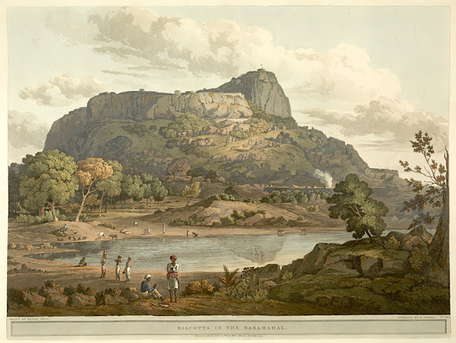
RAYAKOTTAI BY HENRY SALT


HENRY SALT (1780-1827) Rayakottai (No elevation data) India (Tamil Nadu)  In " Riacotta in the Baramahal,' aquatint, from

HENRY SALT (1780-1827)
Rayakottai (No elevation data)
India (Tamil Nadu)

In " Riacotta in the Baramahal,' aquatint, 1806, from  
Twenty Four Views in St. Helena, the Cape, India, Ceylon, the Red Sea, Abyssinia and Egypt, 
 The British Library


About the plate
This aquatint was taken from plate 12 of Henry Salt's Twenty Four Views in St. Helena, the Cape, India, Ceylon, the Red Sea, Abyssinia and Egypt. Salt visited Rayakottai in Tamil Nadu on his way to the Cauvery Falls. Viscount Valentia George Annesley wrote of its importance as a point of communication between Mysore and the Carnatic: "[Governor General] Lord Cornwallis ... had the fortifications strengthened. At present they consist of the hill, whose top is only approachable by a narrow flight of steps, and a fort at the bottom where are very comfortable houses for the officers. The scenery is wild and abrupt, consisting of rocky hills, with woods and jungle between ... the climate is so moderate, that every kind of fruit and vegetable may be reared in a degree of perfection that is unknown on the sultry plains around Madras.". For some reason, this impressed the british  by the fact it was " as high as a mountain". So.... do I year mountain ?

The place
Rayakottai, also spelled Rayakotta is not not really what we can alled a mountain, but a hill or a ridge like there are many others in this blog.  In reality it is a fort ! But it is designed quite like a mountain !!! It is located neat a town in Denkanikottai taluk, Krishnagiri District, Tamil Nadu, India. It is 73 kilometres (45 mi) from Bangalore.  The fort was built by King Krishna deverayar and situated within the town of Rayakottai which is one of the ancient fortress in the Krishnagiri district. It is now one of the protected monument by the Archaeological Survey of India. In the 18th century Hyder Ali and Tipu sultan captured this fort. The fort was captured by Major Gowdie during the third Anglo-Mysore War in 1791. According to the Treaty of Srirangapatna, this fort came into the hands of the British. 

The artist
Henry Salt was an English artist, traveller, collector of antiquities, diplomat, and Egyptologist.
After a time as a portrait painter, Salt was permitted to travel with the English nobleman George Annesley, Viscount Valentia as his secretary and draughtsman after being recommended by Thomas Simon Butt. They started on an eastern tour in June 1802, traveling on the British East India Company's extra (chartered) ship Minerva to India via the Cape Colony. In 1805, Valentia sent Salt on a journey into the Abyssinian area (now Ethiopia) to meet with the ras of Tigré to open up trade relations on behalf of the English. While visiting there, Salt gained the respect of the ras. He returned to England on 26 October 1806. His journey home took him through Egypt where he met the pasha Mehmet Ali. Salt's paintings from the trip were used in Valentia's Voyages and Travels to India, published in 1809. The originals of all the drawings were kept by Valentia, as also the copper plates after Salt's death. The format and style of the plates is similar to Thomas and William Daniell's work, "Oriental Scenery" (1795-1808).
Salt returned to Ethiopia in 1809 on a government mission to explore trade and diplomatic links with the Tigrayan warlord Ras Wolde Selassie. Upon arrival, he was unable to meet with the king due to unrest in the country, so instead he went to stay with his friend the ras of Tigré. During this venture, Salt took on the side mission of verifying and correcting the information about the region reported by the Scottish traveler, James Bruce many years earlier. Salt came back to England in 1811 with numerous specimens of both plants and animals.

___________________________________________
2021 - Wandering Vertexes...
by Francis Rousseau


Saturday, April 24, 2021

ANAMUNDI & WESTERN GHATS BY HENRY SALT

HENRY SALT (1780-1827) Anamundi (2,479 m - 8,133 ft) India   In The Baramahal, Poonah,1809, hand colored aquatints, Western Ghats

HENRY SALT (1780-1827)
Anamundi (2,479 m - 8,133 ft)
India

In The Baramahal, Poonah,1809, hand colored aquatints, private collection


The mountain
Anamudi is a mountain located in the Indian state of Kerala. It is the highest peak in the Western Ghats and South India.  It lies on the border of Devikulam Taluk, Idukki district and Kothamangalam Taluk, Ernakulam district. The name Anamudi literally translates to "elephant's head" a reference to the resemblance of the mountain to an elephant's head. Anamudi Shola National Park (ASNP) was declared as National Park in December 2003. Anamudi is the highest mountain in peninsular India as well as the largest mountain in Kerala. 
The first recorded ascent of Anamudi was by General Douglas Hamilton of the Madras Army on 4 May 1862, but it is likely that there had been earlier ascents by local people. Anamudi peak is one of only three ultra prominent peaks in South India. It is also the peak with the greatest topographic isolation within India. It is the highest point in India south of Himalayas. Thus it is known as "Everest of South India".

 
The artist
Henry Salt was an English artist, traveller, collector of antiquities, diplomat, and Egyptologist.
After a time as a portrait painter, Salt was permitted to travel with the English nobleman George Annesley, Viscount Valentia as his secretary and draughtsman after being recommended by Thomas Simon Butt. They started on an eastern tour in June 1802, traveling on the British East India Company's extra (chartered) ship Minerva to India via the Cape Colony. In 1805, Valentia sent Salt on a journey into the Abyssinian area (now Ethiopia) to meet with the ras of Tigré to open up trade relations on behalf of the English. While visiting there, Salt gained the respect of the ras. He returned to England on 26 October 1806. His journey home took him through Egypt where he met the pasha Mehmet Ali. Salt's paintings from the trip were used in Valentia's Voyages and Travels to India, published in 1809. The originals of all the drawings were kept by Valentia, as also the copper plates after Salt's death. The format and style of the plates is similar to Thomas and William Daniell's work, "Oriental Scenery" (1795-1808).
Salt returned to Ethiopia in 1809 on a government mission to explore trade and diplomatic links with the Tigrayan warlord Ras Wolde Selassie. Upon arrival, he was unable to meet with the king due to unrest in the country, so instead he went to stay with his friend the ras of Tigré. During this venture, Salt took on the side mission of verifying and correcting the information about the region reported by the Scottish traveler, James Bruce many years earlier. Salt came back to England in 1811 with numerous specimens of both plants and animals.

___________________________________________
2021 - Wandering Vertexes...
by Francis Rousseau

Wednesday, February 10, 2021

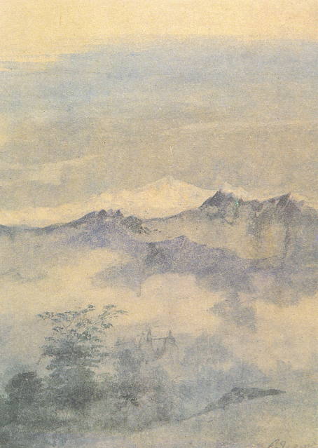
KANGCHENJUNGA PAINTED BY GAGANENDRANATH TAGORE


https://wanderingvertexes.blogspot.com/2021/02/kangchenjunga-painted-by-gaganendranath.html

GAGANENDRANATH  TAGORE  (1867-1938)
Kangchenjunga (8, 538m - 28,169 ft)
India, Népal

In Kangchenjunga, watercolor,  National Gallery of Modern Art, New Delhi


The painter
Gaganendranath Tagore was an Indian painter and cartoonist of the Bengal school. Along with his brother Abanindranath Tagore, he was counted as one of the earliest modern artists in India. Gaganendranath Tagore was born at Jorasanko into a family whose creativity defined Bengal's cultural life. Gaganendranath was the eldest son of Gunendranath Tagore, grandson of Girindranath Tagore and a great-grandson of Prince Dwarkanath Tagore. His brother Abanindranath was a pioneer and leading exponent of the Bengal School of Art. He was a nephew of the poet Rabindranath Tagore and the paternal great-grandfather of actress Sharmila Tagore. Gaganendranath received no formal education but trained under the watercolourist Harinarayan Bandopadhyay. In 1907, along with his brother Abanindranath, he founded the Indian Society of Oriental Art which later published the influential journal Rupam. Between 1906 and 1910, the artist studied and assimilated Japanese brush techniques and the influence of Far Eastern art into his own work, as demonstrated by his illustrations for Rabindranath Tagore's autobiography Jeevansmriti (1912). He went on to develop his own approach in his Chaitanya and Pilgrim series. Gaganendranath eventually abandoned the revivalism of the Bengal School and took up caricature. The Modern Review published many of his cartoons in 1917. From 1917 onwards, his satirical lithographs appeared in a series of books, including Play of Opposites, Realm of the Absurd and Reform Screams.
Between 1920 and 1925, Gaganendranath pioneered experiments in modernist painting.  Partha Mitter describes him as "the only Indian painter before the 1940s who made use of the language and syntax of Cubism in his painting". From 1925 onwards, the artist developed a complex post-cubist style.

The mountain
Kangchenjunga (8,586 m - 28,169 ft) is the third highest mountain in the world. It lies partly in Nepal and partly in Sikkim, India. Kangchenjunga is the second highest mountain of the Himalayas after Mount Everest. Three of the five peaks – Main, Central and South – are on the border between North Sikkim and Nepal. Two peaks are in the Taplejung District, Nepal.
Kangchenjunga Main is the highest mountain in India, and the easternmost of the mountains higher than 8,000 m (26,000 ft).
Until 1852, Kangchenjunga was assumed to be the highest mountain in the world, but calculations based on various readings and measurements made by the Great Trigonometrical Survey of India in 1849 came to the conclusion that Mount Everest., known as Peak XV at the time, was the highest.
It is listed int the Eight Thousanders and as Seven Third Summits
Kangchenjunga is the official spelling adopted by Douglas Freshfield, A. M. Kellas, and the Royal Geographical Society that gives the best indication of the Tibetan pronunciation. Freshfield referred to the spelling used by the Indian Government since the late 19th century. There are a number of alternative spellings including Kangchendzцnga, Khangchendzonga, and Kanchenjunga.
Local Lhopo people believe that the treasures are hidden but reveal to the devout when the world is in peril; the treasures comprise salt, gold, turquoise and precious stones, sacred scriptures, invincible armor or ammunition, grain and medicine. Kangchenjunga's name in the Limbu language is Senjelungma or Seseylungma, and is believed to be an abode of the omnipotent goddess Yuma Sammang.
It rises in a section of the Himalayas called Kangchenjunga Himal that is limited in the west by the Tamur River, in the north by the Lhonak Chu and Jongsang La, and in the east by the Teesta River. It lies about 128 km (80 mi) east of Mount Everest.
Allowing for further verification of all calculations, it was officially announced in 1856 that
Kangchenjunga was first climbed on 25 May 1955 by Joe Brown and George Band, who were part of a British expedition. They stopped short of the summit as per the promise given to the Chogyal that the top of the mountain would remain inviolate. Every climber or climbing group that has reached the summit has followed this tradition...

____________________________

2021 - Wandering Vertexes...
by Francis Rousseau

Thursday, October 29, 2020

INDRASAN PAINTED BY VASILY VERESHCHAGIN


VASILY VERESHCHAGIN (1842-1904)
Mount Idrasan (6,621m - 21, 722ft)
India, Pakistan

In Glacier on the Road from Kashmir to Ladakh, 1875,  Tretyakov Gallery Moscow.

The mountain
Mount Indrasan (6,621m - 21, 722ft) is located in Kullu district, Himachal Pradesh. Mt. Indrasan is considered as the most difficult mountain to climb in the Pir Panjal range of the Himalayas because of the challenges involved in scaling it. It was first climbed on October 13, 1962 by an expedition organized by Kyoto University Alpine Club, Kyoto, Japan. It is also believed that whenever Lord Indra arrives on earth he resides here. Indrasan i.e. the royal seat of the Lord Indra. The Pir Panjal Range also Panchaladeva in Hindu scriptures, is a group of mountains in the Lesser Himalayan region, running from east-southeast (ESE) to west-northwest (WNW) across the Indian state of Himachal Pradesh, the Indian administrated Union Territory of Jammu and Kashmir and the Pakistani administered territory of Azad Kashmir, where the average elevation varies from 1,400 m (4,600 ft) to 4,100 m (13,500 ft). The Himalayas show a gradual elevation towards the Dhauladhar and Pir Panjal ranges. Pir Panjal is the largest range of the Lesser Himalayas. The region is connected to the Valley of Kashmir via Mughal Road and used to be the historical connection of Kashmir with India.

 
The painter
Vasily Vasilyevich Vereshchagin (Васи́лий Васи́льевич Вереща́гин) transcribed in English as "Basil Verestchagin", was one of the most famous Russian war artists and one of the first Russian artists to be widely recognized abroad. The graphic nature of his realist scenes led many of them to never be printed or exhibited. In 1864 he proceeded to Paris, where he studied under Jean-Léon Gérôme, though he dissented widely from his master's methods. In the Paris Salon of 1866 he exhibited a drawing of Dukhobors chanting their Psalms. In the next year he was invited to accompany General Konstantin Kaufman's expedition to Turkestan. He was an indefatigable traveler, returning to St. Petersburg in late 1868, to Paris in 1869, back to St. Petersburg later in the year, and then back to Turkestan at the end 1869 via Siberia. In 1871, he established an atelier in Munich, and made a solo exhibition of his works at the Crystal Palace in London in 1873.
More about the painter

____________________________________

Wandering Vertexes 2020
A blog by Francis Rousseau

Tuesday, March 10, 2020

KANGCHENJUNGA (3) PAINTED BY NICHOLAS ROERICH


NICHOLAS ROERICH (1874-1947),
Kangchenjunga (8, 538m - 28,169 ft)
India, Népal

In Kangchenjunga mountains lakes 1931, tempera on canvas, Private collection

The mountain
Kangchenjunga (8,586 m - 28,169 ft) is the third highest mountain in the world. It lies partly in Nepal and partly in Sikkim, India. Kangchenjunga is the second highest mountain of the Himalayas after Mount Everest. Three of the five peaks – Main, Central and South – are on the border between North Sikkim and Nepal. Two peaks are in the Taplejung District, Nepal.
Kangchenjunga Main is the highest mountain in India, and the easternmost of the mountains higher than 8,000 m (26,000 ft).
Until 1852, Kangchenjunga was assumed to be the highest mountain in the world, but calculations based on various readings and measurements made by the Great Trigonometrical Survey of India in 1849 came to the conclusion that Mount Everest., known as Peak XV at the time, was the highest.
It is listed int the Eight Thousanders and as Seven Third Summits
Kangchenjunga is the official spelling adopted by Douglas Freshfield, A. M. Kellas, and the Royal Geographical Society that gives the best indication of the Tibetan pronunciation. Freshfield referred to the spelling used by the Indian Government since the late 19th century. There are a number of alternative spellings including Kangchendzцnga, Khangchendzonga, and Kanchenjunga.
Local Lhopo people believe that the treasures are hidden but reveal to the devout when the world is in peril; the treasures comprise salt, gold, turquoise and precious stones, sacred scriptures, invincible armor or ammunition, grain and medicine. Kangchenjunga's name in the Limbu language is Senjelungma or Seseylungma, and is believed to be an abode of the omnipotent goddess Yuma Sammang.
It rises in a section of the Himalayas called Kangchenjunga Himal that is limited in the west by the Tamur River, in the north by the Lhonak Chu and Jongsang La, and in the east by the Teesta River. It lies about 128 km (80 mi) east of Mount Everest.
Allowing for further verification of all calculations, it was officially announced in 1856 that
Kangchenjunga was first climbed on 25 May 1955 by Joe Brown and George Band, who were part of a British expedition. They stopped short of the summit as per the promise given to the Chogyal that the top of the mountain would remain inviolate. Every climber or climbing group that has reached the summit has followed this tradition...

The painter
Nicholas Roerich known also as Nikolai Konstantinovich Rerikh (Никола́й Константи́нович Ре́рих) is quite an important figure of mountain paintings in the early 20th century. He was a Russian painter, writer, archaeologist, theosophist, perceived by some in Russia as an enlightener, philosopher, and public figure. In his youth was he was quite influenced by a movement in Russian society around the occult and was interested in hypnosis and other spiritual practices. His paintings are said to have hypnotic expression.
More about the painter = >

_______________________________ 

2020 - Wandering Vertexes...
by Francis Rousseau

Saturday, January 25, 2020

KANGCHENJUNGA (2) PAINTED BY NICHOLAS ROERICH


NICHOLAS ROERICH (1874-1947),
Kangchenjunga (8, 538m - 28,169 ft)
India, Népal

In Kangchenjunga at sunset  1944, tempera on canvas, Private collection

The mountain
Kangchenjunga (8,586 m - 28,169 ft) is the third highest mountain in the world. It lies partly in Nepal and partly in Sikkim, India. Kangchenjunga is the second highest mountain of the Himalayas after Mount Everest. Three of the five peaks – Main, Central and South – are on the border between North Sikkim and Nepal. Two peaks are in the Taplejung District, Nepal.
Kangchenjunga Main is the highest mountain in India, and the easternmost of the mountains higher than 8,000 m (26,000 ft).
Until 1852, Kangchenjunga was assumed to be the highest mountain in the world, but calculations based on various readings and measurements made by the Great Trigonometrical Survey of India in 1849 came to the conclusion that Mount Everest., known as Peak XV at the time, was the highest.
It is listed int the Eight Thousanders and as Seven Third Summits
Kangchenjunga is the official spelling adopted by Douglas Freshfield, A. M. Kellas, and the Royal Geographical Society that gives the best indication of the Tibetan pronunciation. Freshfield referred to the spelling used by the Indian Government since the late 19th century. There are a number of alternative spellings including Kangchendzцnga, Khangchendzonga, and Kanchenjunga.
Local Lhopo people believe that the treasures are hidden but reveal to the devout when the world is in peril; the treasures comprise salt, gold, turquoise and precious stones, sacred scriptures, invincible armor or ammunition, grain and medicine. Kangchenjunga's name in the Limbu language is Senjelungma or Seseylungma, and is believed to be an abode of the omnipotent goddess Yuma Sammang.
It rises in a section of the Himalayas called Kangchenjunga Himal that is limited in the west by the Tamur River, in the north by the Lhonak Chu and Jongsang La, and in the east by the Teesta River. It lies about 128 km (80 mi) east of Mount Everest.
Allowing for further verification of all calculations, it was officially announced in 1856 that
Kangchenjunga was first climbed on 25 May 1955 by Joe Brown and George Band, who were part of a British expedition. They stopped short of the summit as per the promise given to the Chogyal that the top of the mountain would remain inviolate. Every climber or climbing group that has reached the summit has followed this tradition...

The painter
Nicholas Roerich known also as Nikolai Konstantinovich Rerikh (Никола́й Константи́нович Ре́рих) is quite an important figure of mountain paintings in the early 20th century. He was a Russian painter, writer, archaeologist, theosophist, perceived by some in Russia as an enlightener, philosopher, and public figure. In his youth was he was quite influenced by a movement in Russian society around the occult and was interested in hypnosis and other spiritual practices. His paintings are said to have hypnotic expression.
More about the painter = >

_______________________________ 

2020 - Wandering Vertexes...
by Francis Rousseau

Thursday, December 26, 2019

KANGJENCHUNGA & PANDIM BY VASILY VERESHCHAGIN


VASILY VERESHCHAGIN (1842-1904)
Kangchenjunga (8, 538m - 28,169 ft) 
 Mount Pandim (6, 691 m - 21, 952 ft)
India, Népal

In Kanchinjinga, Pandim and other Mountains in the Clouds, oil on canvas, 46.3 x 64.7 cm, 1879, Private collection, Christie's


About this painting,
Very sumilar to the   Sunset in the Himalayas painted  by  Vereshchagin  the same year in 1879, that painting is  often confused with. If the impressionist technic of painting,  the frame (vegetation in the foreground) and  the colours are the same,  the view is not the same. 

About the mountains
 Kangchenjunga   (8,586 m - 28,169 ft) is the third highest mountain in the world. It lies partly in Nepal and partly in Sikkim, India. Kangchenjunga is the second highest mountain of the Himalayas after Mount Everest. Three of the five peaks – Main, Central and South – are on the border between North Sikkim and Nepal. Two peaks are in the Taplejung District, Nepal.
Kangchenjunga Main is the highest mountain in India, and the easternmost of the mountains higher than 8,000 m (26,000 ft).
Until 1852, Kangchenjunga was assumed to be the highest mountain in the world, but calculations based on various readings and measurements made by the Great Trigonometrical Survey of India in 1849 came to the conclusion that Mount Everest., known as Peak XV at the time, was the highest. It is listed int the Eight Thousanders and as Seven Third Summits...
Mount Pandim (6,691 m - 21,952 ft) is a Himalayan mountain located in the Sikkim province, India. It is considered often as a part of the Kangchenjunga mountains. Kangchenjunga (sometimes spelled Kanchenjunga), is the third highest mountain in the world, and lies partly in Nepal and partly in Sikkim (India).  It lies about 128 km east of Mount Everest.


The painter
Vasily Vasilyevich Vereshchagin (Васи́лий Васи́льевич Вереща́гин) transcribed in English as "Basil Verestchagin", was one of the most famous Russian war artists and one of the first Russian artists to be widely recognized abroad. The graphic nature of his realist scenes led many of them to never be printed or exhibited. In 1864 he proceeded to Paris, where he studied under Jean-Léon Gérôme, though he dissented widely from his master's methods. In the Paris Salon of 1866 he exhibited a drawing of Dukhobors chanting their Psalms. In the next year he was invited to accompany General Konstantin Kaufman's expedition to Turkestan. He was an indefatigable traveler, returning to St. Petersburg in late 1868, to Paris in 1869, back to St. Petersburg later in the year, and then back to Turkestan at the end 1869 via Siberia. In 1871, he established an atelier in Munich, and made a solo exhibition of his works at the Crystal Palace in London in 1873.
In late 1874, he departed for an extensive tour of the Himalayas, India and Tibet, spending over two years in travel. He returned to Paris in late 1876
After the war, Vereshchagin settled at Munich, where he produced his war pictures so rapidly that he was freely accused of employing assistants. The sensational subjects of his pictures, and their didactic aim, the promotion of peace by a representation of the horrors of war, attracted a large section of the public not usually interested in art to the series of exhibitions of his pictures in Paris in 1881 and subsequently in London, Berlin, Dresden, Vienna and other cities.
By the late 19th century, Vereshchagin had gained popularity not only in Russia, but also abroad and his name never left the pages of the European and American press. From his earliest works, unlike most contemporary battle pieces depicting war as a kind of parade, Vereshchagin graphically depicted the horrors of war. "I loved the sun all my life, and wanted to paint sunshine. When I happened to see warfare and say what I thought about it, I rejoiced that I would be able to devote myself to the sun once again. But the fury of war continued to pursue me," Vereshchagin wrote. One day, in 1882, Vereshchagin’s exhibition in Berlin was visited by German Field Marshal Helmuth von Moltke the Elder. Vereshchagin brought Moltke to his painting The Apotheosis of War. The picture evoked a sort of confusion in the Field Marshal. After his visit to the exhibition, Moltke issued an order forbidding German soldiers to visit it. The Austrian war minister did the same. He also declined the artist's offer to let Austrian officers see his pictures at the 1881 exhibition in Vienna free of charge.

___________________________________
Wandering Vertexes 2019
A blog by Francis Rousseau

Wednesday, November 13, 2019

MOUNT INDRASAN BY NICHOLAS ROERICH


NICHOLAS ROERICH (1874-1947)
Mount Indrasan  (6,221m - 20,410 ft)
India - Pakistan border 

In Ladakh,  oil on canvas, 1929

The mountain
Mount Indrasan  (6221m - 20,410 ft) is located  in Kullu district, Himachal Pradesh.  Mt. Indrasan is one of the difficult peaks in the Himalayas because of the challenges involved in scaling it. It is also believed that whenever Lord Indra arrives on earth he resides here. Indrasan (composed of two words: Indra and Aasana) i.e. the royal seat of the Lord Indra.  With Deo Tibba (6,001 m- 19,688 ft))  Indrasan is one of the  two important peaks at the eastern end of the Pir Panjal Range. They can be approached from both the Parvati-Beas Valley (Kulu District), Upper Belt of Chamba Himachal Pradesh and the Chandra (Upper Chenab) Valley (Lahaul and Spiti District) in Himachal Pradesh. The hill station of Gulmarg in Kashmir lies in this range.

The painter
Nicholas Roerich known also as Nikolai Konstantinovich Rerikh (Никола́й Константи́нович Ре́рих) is quite an important figure of mountain paintings in the early 20th century. He was a Russian painter, writer, archaeologist, theosophist, perceived by some in Russia as an enlightener, philosopher, and public figure. In his youth was he was quite influenced by a movement in Russian society around the occult and was interested in hypnosis and other spiritual practices. His paintings are said to have hypnotic expression.
More about the painter = >

___________________________

2019 - Wandering Vertexes...
by Francis Rousseau

Saturday, October 19, 2019

KANGCHENJUNGA AT NIGHT BY NICHOLAS ROERICH


https://wanderingvertexes.blogspot.com/2019/10/kangchenjunga-at-night-by-nicholas.html 

NICHOLAS ROERICH (1874-1947), 
Kangchenjunga (8, 538m - 28,169 ft) 
India, Népal

 In  Himalayas at night, Sikkim, 1928-29, tempera on canvas, Private collection

The mountain 
 Kangchenjunga (8,586 m - 28,169 ft) is the  third highest mountain in the world. It  lies partly in Nepal and partly in Sikkim, India.  Kangchenjunga is the second highest mountain of the Himalayas after Mount Everest. Three of the five peaks – Main, Central and South – are on the border between North Sikkim and Nepal. Two peaks are in the Taplejung District, Nepal.
Kangchenjunga Main is the highest mountain in India, and the easternmost of the mountains higher than 8,000 m (26,000 ft).  
Until 1852, Kangchenjunga was assumed to be the highest mountain in the world, but calculations based on various readings and measurements made by the Great Trigonometrical Survey of India in 1849 came to the conclusion that Mount Everest., known as Peak XV at the time, was the highest.  
It is listed int the  Eight Thousanders and as Seven Third Summits
Kangchenjunga is the official spelling adopted by Douglas Freshfield, A. M. Kellas, and the Royal Geographical Society that gives the best indication of the Tibetan pronunciation. Freshfield referred to the spelling used by the Indian Government since the late 19th century. There are a number of alternative spellings including Kangchendzцnga, Khangchendzonga, and Kanchenjunga.  
Local Lhopo people believe that the treasures are hidden but reveal to the devout when the world is in peril; the treasures comprise salt, gold, turquoise and precious stones, sacred scriptures, invincible armor or ammunition, grain and medicine. Kangchenjunga's name in the Limbu language is Senjelungma or Seseylungma, and is believed to be an abode of the omnipotent goddess Yuma Sammang.
It rises in a section of the Himalayas called Kangchenjunga Himal that is limited in the west by the Tamur River, in the north by the Lhonak Chu and Jongsang La, and in the east by the Teesta River. It lies about 128 km (80 mi) east of Mount Everest.
Allowing for further verification of all calculations, it was officially announced in 1856 that
Kangchenjunga was first climbed on 25 May 1955 by Joe Brown and George Band, who were part of a British expedition. They stopped short of the summit as per the promise given to the Chogyal that the top of the mountain would remain inviolate. Every climber or climbing group that has reached the summit has followed this tradition...

The painter 
Nicholas Roerich known also as Nikolai Konstantinovich Rerikh (Никола́й Константи́нович Ре́рих) is quite an important figure of mountain paintings in the early 20th century. He was a Russian painter, writer, archaeologist, theosophist, perceived by some in Russia as an enlightener, philosopher, and public figure. In his youth was he was quite influenced by a movement in Russian society around the occult and was interested in hypnosis and other spiritual practices. His paintings are said to have hypnotic expression.

_______________________________
2019 - Wandering Vertexes...

by Francis Rousseau 

Saturday, May 25, 2019

KANGCHENJUGA (2) BY JOSEPH DALTON HOOKER


JOSEPH DALTON HOOKER (1817-1911)
Kangchenjunga (8, 538m-28,169 ft) 
India, Népal

In Campsite in the Himalayas, watercolor on sketchbook 

The mountain
Kangchenjunga (8,586 m (28,169 ft) is the third highest mountain in the world. It lies partly in Nepal and partly in Sikkim, India. Kangchenjunga is the second highest mountain of the Himalayas after Mount Everest. Three of the five peaks – Main, Central and South – are on the border between North Sikkim and Nepal. Two peaks are in the Taplejung District, Nepal.
Kangchenjunga Main is the highest mountain in India, and the easternmost of the mountains higher than 8,000 m (26,000 ft). Until 1852, Kangchenjunga was assumed to be the highest mountain in the world, but calculations based on various readings and measurements made by the Great Trigonometrical Survey of India in 1849 came to the conclusion that Mount Everest, known as Peak XV at the time, was the highest. It is listed int the Eight Thousanders and as Seven Third Summits
Kangchenjunga is the official spelling adopted by Douglas Freshfield, A. M. Kellas, and the Royal Geographical Society that gives the best indication of the Tibetan pronunciation. Freshfield referred to the spelling used by the Indian Government since the late 19th century. There are a number of alternative spellings including Kangchendzцnga, Khangchendzonga, and Kanchenjunga. Local Lhopo people believe that the treasures are hidden but reveal to the devout when the world is in peril; the treasures comprise salt, gold, turquoise and precious stones, sacred scriptures, invincible armor or ammunition, grain and medicine. Kangchenjunga's name in the Limbu language is Senjelungma or Seseylungma, and is believed to be an abode of the omnipotent goddess Yuma Sammang.
It rises in a section of the Himalayas called Kangchenjunga Himal that is limited in the west by the Tamur River, in the north by the Lhonak Chu and Jongsang La, and in the east by the Teesta River. It lies about 128 km (80 mi) east of Mount Everest.
Allowing for further verification of all calculations, it was officially announced in 1856 that
Kangchenjunga was first climbed on 25 May 1955 by Joe Brown and George Band, who were part of a British expedition. They stopped short of the summit as per the promise given to the Chogyal that the top of the mountain would remain inviolate. Every climber or climbing group that has reached the summit has followed this tradition. Other members of this expedition included John Angelo Jackson and Tom Mackinon. In May 1979, Doug Scott, Peter Boardman and Joe Tasker established a new route on the North Ridge their third ascent which was the first one ever made without oxygen.
In 1983, Pierre Beghin made the first solo ascent accomplished without the use of supplemental oxygen. In 1992, Wanda Rutkiewicz was the first woman in the world to ascend and descend K2 and a world-renowned Polish climber, died after she insisted on waiting for an incoming storm to pass, which she did not survive. In 1998, Ginette Harrison was the first woman who climbed Kangchenjunga North face ; Gerlinde Kaltenbrunner, an Austrian mountaineer, was the second woman to reach the summit in 2006.
In May 2014, the Bulgarian diabetic climber Boyan Petrov reached the peak without the use of supplemental oxygen.

The artist
Sir Joseph Dalton Hooker OM GCSI CB PRS was one of the greatest British botanists and explorers of the 19th century. He was a founder of geographical botany and Charles Darwin's closest friend. For twenty years he served as director of the Royal Botanical Gardens, Kew, succeeding his father, William Jackson Hooker, and was awarded the highest honours of British science. He reminded famous for his Voyages to Antarctic (1839-1843), Himalayas and India (1847-1851), Palestine (1860), Morocco (1871), and Western United Statesof America (1877). He is the first European to have sketched Mount Everest and Himalayas (see above) as well as Mount Erebus and Mont Terror in Antarctic.
On 11 November 1847 Hooker left England for his three-year-long Himalayan expedition; he would be the first European to collect plants in the Himalaya. He arrived in Calcutta on 12 January 1848, leaving on 28th to begin his travels with a geological survey party under 'Mr Williams', who he left on 3 March to continue travelling by elephant to Mirzapur, up the Ganges by boat to Siliguri and overland by pony to Darjeeling, arriving on 16 April 1848.
Hooker and a sizeable party of local assistants departed for eastern Nepal on 27 October 1848. They travelled to Zongri, west over the spurs of Kangchenjunga, and north west along Nepal's passes into Tibet. In April 1849 he planned a longer expedition into Sikkim. Leaving on 3 May, he travelled north west up the Lachen Valley to the Kongra Lama Pass and then to the Lachoong Pass. Campbell and Hooker were imprisoned by the Dewan of Sikkim as they travelled towards the Cho La in Tibet. A British team was sent to negotiate with the king of Sikkim. However, they were released without any bloodshed and Hooker returned to Darjeeling, where he spent January and February 1850 writing his journals, replacing specimens lost during his detention and planning a journey for his last year in India.
In an article of the Alpine Journal, it was demonstrated by Stephen Goodwin how the sketch above is the very first known drawing in situ of Mount Everest. "Is this 1848 sketch by Joseph Dalton Hooker the first recorded view of Mount Everest by a European? Drawn in situ on the ‘Choonjerma pass’ – now generally referred to as the Mirgin la – in eastern Nepal, it has, for many years, lain unidentified in the archives at the Royal Botanic Gardens, Kew. Its ‘discovery’ adds one more facet to the remarkable accomplishments of Hooker during his three years of exploration and research in the eastern Himalaya."

___________________________________________
2019 - Wandering Vertexes...
by Francis Rousseau 

Monday, April 8, 2019

SINIOLCHU PHOTOGRAPHED IN 1899 BY VITTORIO SELLA


VITTORIO SELLA (1859-1943)
Siniolchu  (6,888 m -22,598 ft)
India (Sikkim) 

In Siniolchu  seen from  the Zemu  Glacier, silver gelatine print, 
396 x 297 mm, from an 18 x 24 plate), 1899. 
Fondazione Sella, Biella

The mountain 
Siniolchu  (6,888 m -22,598 ft) is one of the tallest mountains of the Indian state of Sikkim. Siniolchu is considered to be particularly aesthetically attractive, having been described by Douglas Freshfield as "the most superb triumph of mountain architecture and the most beautiful snow mountain in the world". It is situated near the green lake adjacent to Kangchenjunga, the highest peak in the state and third highest in the world. Siniolchu’s summit was first scaled in 1936 by the German climbers Karl Wien and Adi Gцttner.  Later Sikkimese Everest climber, Sonam Gyatso, also scaled the top.

The photographer

Vittorio Sella is a mountain italian climber and photographer who took his passion for mountains from his uncle, Quintino Sella, founder of the Italian Alpine Club.  He accomplished many remarkable climbs in the Alps, the first wintering in the Matterhorn and Mount Rose (1882) and the first winter crossing of Mont Blanc (1888).
He took part in various expeditions outside Italy:
- Three in the Caucasus in 1889, 1890 and 1896 where a summit still bears his name;
- The ascent of Mount Saint Elias in Alaska in 1897
- Sikkim and Nepal in 1899 (photo above)
- Possibly climb Mount Stanley in Uganda in 1906 during an expedition to the Rwenzori
- Recognition at K2  and Mustagh Tower in 1909
- In Morocco in 1925.
During expeditions in Alaska, Uganda and Karakoram (K2-Chogolisa), he accompanied the Duke of Abruzzi, Prince Luigi Amedeo di Savoia.
Full Wandering Vertexes entry  =>

___________________________________________
2019 - Wandering Vertexes...
by Francis Rousseau 

Wednesday, March 27, 2019

BAZGO GOMPA BY NICHOLAS ROERICH


NICHOLAS ROERICH (1874-1947)
Basgo or Bazgo Gompa (3,292 m - 10 800 ft))
India

In Himalayas (Bazgo. Ladakh), oil on canvas, 1940

The site
Basgo or Bazgo Gompa (3,292 m - 10 800 ft  refers to a Buddhist monastery located in the city of Basgo or Bazgo, 40 km east of Leh, the capital of Ladakh, in the state of Jammu and Kashmir in India. The monastery is strategically located at the top of a hill at 3,292 m above sea level. It overlooks the remains of the ancient city.
It was built by the rulers of Namgyal in 1680. The sovereign Delegs Namgyal (1675-1705) having undertaken an expansion of the territory and the dissemination of his lineage, intended to protect his country Mongolian armies of Tibet.
Bazgo is deeply rooted in the origins of Ladakh.
It was once an important cultural and political center, which is frequently mentioned in the Ladakhi Chronicles. The monastery is also famous for the Buddha statue which stands in a precarious position on the cliffs 300 meters above the village.
Since 1993, the Basgo Welfare Committee has made great efforts to save the three sanctuaries of Chamchung, Chamba Lakhang and Serzang temples dedicated to the Maitreya Buddhas, which are kept in spectacular enclosures. Maitreya is a Mahābodhisattva who would be the next Buddha to come when the Dharma, the teaching of Shakyamuni Buddha, will have disappeared.
Since UNESCO has listed Basgo among the top 100 most endangered sites in the world in 2001, the Basgo Welfare Committee has taken steps to safeguard the monument by housing it in a richly decorated structure. The complex also includes murals.

The painter 
Nicholas Roerich known also as Nikolai Konstantinovich Rerikh (Никола́й Константи́нович Ре́рих) is quite an important figure of mountain paintings in the early 20th century.  He was a Russian painter, writer, archaeologist, theosophist, perceived by some in Russia as an enlightener, philosopher, and public figure. In his youth was he was quite influenced by a movement in Russian society around the occult and was interested in hypnosis and other spiritual practices. His paintings are said to have hypnotic expression.
Born in Saint Petersburg, Russia, he lived in various places around the world until his death in Naggar, Himachal Pradesh, India. Trained as an artist and a lawyer, his main interests were literature, philosophy, archaeology, and especially art. After the February Revolution of 1917 and the end of the czarist regime, Roerich, a political moderate who valued Russia's cultural heritage more than ideology and party politics, had an active part in artistic politics. With Maxim Gorky and Aleksandr Benois, he participated with the so-called "Gorky Commission" and its successor organization, the Arts Union (SDI).
Full Wandering Vertexes entry  =>
______________________________
2019 - Wandering Vertexes...
by Francis Rousseau 

Friday, January 11, 2019

STOK KANGRI / KANGLACHAN PEAK BY SIR JOSEPH DALTON HOOKER


SIR JOSEPH DALTON HOOKER (1817-1911), 
Stok Kangri / Kanglachan Peak (6,154 m -20,190 ft)
India 

In Moraines - Kanglachan, watercoulour on paper, 1850 

The mountain 
Stok Kangri  also known as Kanglachan Peak (6,154 m -20,190 ft)) is the highest mountain in the Stok Range of the Himalayas in the Ladakh region of north-west India. The peak is located in Hemis National Park, 12 km southwest of the trailhead in the village of Stok and around 15 km southwest of the city of Leh, the capital of Ladakh.
Despite its high altitude, Stok Kangri is a popular trekking peak and is often climbed as an initial non-technical foray into high altitude mountaineering. However, the difficulty of Stok Kangri is often underestimated and the need to acclimatise before and during the ascent makes Stok Kangri an enduring challenge.
In late July and August, all but the top of the peak may be snow-free. The elevation data was verified by GPS readings from 11 satellites at the Summit during a late July 2007 joint Nepalese-US expedition which encountered snow cover for 85% of the final four-hour, four km, 900 metre climb. Another GPS reading provided a 6136-meter elevation. The shortest route to the peak is along the Stok valley, following the Stok Chu to Stok village. This valley's grazing landscape, especially near the village, was devastated by the 2010 Ladakh floods, the most severe in decades.


The artist 
Sir Joseph Dalton Hooker OM GCSI CB PRS was one of the greatest British botanists and explorers of the 19th century. He was a founder of geographical botany and Charles Darwin's closest friend. For twenty years he served as director of the Royal Botanical Gardens, Kew, succeeding his father, William Jackson Hooker, and was awarded the highest honours of British science. He reminded famous for his Voyages to Antarctic (1839-1843), Himalayas and India (1847-1851), Palestine (1860), Morocco (1871), and Western United Statesof America (1877).  He is the first European to have sketched Mount Everest and Himalayas (see above) as well as Mount Erebus and Mont Terror in Antarctic.
Voyage to the Himalayas and India 1847–1851
On 11 November 1847 Hooker left England for his three-year-long Himalayan expedition; he would be the first European to collect plants in the Himalaya.  He arrived in Calcutta on 12 January 1848, leaving on 28th to begin his travels with a geological survey party under 'Mr Williams', who he left on 3 March to continue travelling by elephant to Mirzapur, up the Ganges by boat to Siliguri and overland by pony to Darjeeling, arriving on 16 April 1848.
Hooker and a sizeable party of local assistants departed for eastern Nepal on 27 October 1848. They travelled to Zongri, west over the spurs of Kangchenjunga, and north west along Nepal's passes into Tibet. In April 1849 he planned a longer expedition into Sikkim. Leaving on 3 May, he travelled north west up the Lachen Valley to the Kongra Lama Pass and then to the Lachoong Pass. Campbell and Hooker were imprisoned by the Dewan of Sikkim as they travelled towards the Cho La in Tibet. A British team was sent to negotiate with the king of Sikkim. However, they were released without any bloodshed and Hooker returned to Darjeeling, where he spent January and February 1850 writing his journals, replacing specimens lost during his detention and planning a journey for his last year in India.
In an article of the Alpine Journal, it was demonstrated by Stephen Goodwin how the sketch above is the very first known drawing in situ of Mount Everest.  "Is this 1848 sketch by Joseph Dalton Hooker the first recorded view of Mount Everest by a European? Drawn in situ on the ‘Choonjerma pass’ – now generally referred to as the Mirgin la – in eastern Nepal, it has, for many years, lain unidentified in the archives at the Royal Botanic Gardens, Kew. Its ‘discovery’ adds one more facet to the remarkable accomplishments of Hooker during his three years of exploration and research in the eastern Himalaya."

_______________________________

2019 - Wandering Vertexes...
by Francis Rousseau 

Monday, December 10, 2018

BHAGIRATHI I, II & III BY SAMUEL BOURNE


SAMUEL BOURNE  (1834–1912)
Bhagirathi II  (6,512 m - 21,365 ft)
Bhagirathi III  6,454 m  -21,175 ft)
Bhagirathi  I (6,856 m-  22,493 ft)  
India 

 In Gangotri Glacier and the Bhagirathi Peaks, gelatine on glass, 1866, The British Libray

About the photo 
'Samuel Bourne, the bank clerk and amateur photographer, arrived in India in 1863 during the early years of commercial photography. Photographs taken during three expeditions to Kashmir and the Himalayas between 1863 and 1866 demonstrate his ability to combine technical skill and artistic vision. These views display a compositional elegance which appealed to Victorian notions of the ‘picturesque’; strategically framed landscapes of rugged mountain scenery, forests, rivers, lakes and rural dwellings. 
Copies of this spectacular and very early photograph of the Himalayas by pioneer photographer Samuel Bourne are held in the collections of the Fogg Museum, Harvard University (2.2002.112), Duke University Library (as part of RL.00130), and the British Library (94/4 25).

The photographer 
Samuel Bourne  was a British photographer known for his prolific seven years' work in India, from 1863 to 1870. Together with Charles Shepherd, he set up Bourne & Shepherd first in Shimla in 1863 and later in Kolkata (Calcutta). The company closed only two years ago, in June 2016 ! 
Bourne spent six extremely productive years in India, and by the time he returned to England in January 1871, he had made approximately 2,200 fine images of the landscape and architecture of India and the Himalayas. Working primarily with a 10x12 inch plate camera, and using the complicated and laborious Wet Plate Collodion process, the impressive body of work he produced was always of superb technical quality and often of artistic brilliance.  His ability to create superb photographs whilst travelling in the remotest areas of the Himalayas and working under the most exacting physical conditions, places him firmly amongst the very finest of nineteenth century travel photographers.
On 29 July 1863, he left Simla on the first of his three major Himalayan photographic expeditions. With a retinue of some 30 porters to carry his equipment, he travelled across the Simla Hills to Chini, in the Valley of the Sutlej River, 160 miles north-east of Simla, and spent some time photographing in the Chini-Sutlej River area, before heading up to the borders of Spiti, and returning to Simla on 12 October 1863, with 147 fine negatives.
In 1867, Bourne journeyed on up to the  Gangotri Glacier (see  photo above). There he went on to photograph one of the prime sources of the Ganges, as it issued from the mouth of the glacial ice cave at Gaumukh. His return journey took in Agra, Mussoorie, Roorkee, Meerut and Naini Tal, and he arrived back in Simla, again in time for Christmas! He wrote extensively about his travels in the Himalayas (one of the very few photographers in India to do so), in a long series of letters, which appeared in The British Journal of Photography, between 1863 and 1870.


The mountains 
Bhagirathi I ( 6,856 - 22,493 ft),  Bhagirathi II (6,512 - 21,365 ft),  Bhagirathi III (6,454 m-21,175 ft), are peaks with moderate routes on the back sides, but huge steep-to-overhanging cliffs on the side facing the glacier. Bhagirathi III, in particular, has seen some of the most extreme rock climbing in the Himalaya. They  are part of The Gangotri Group of mountains, a subdivision of the Garhwal Himalaya in the northern Indian state of Uttarakhand. It rings the Gangotri Glacier, and contains peaks that are notable either for their religious significance to Hindus, for their difficult climbing routes, or both. Climbs on three of the peaks (Thalay Sagar, Shivling, and Meru) have resulted in the awarding of the prestigious (but controversial) climbing award, the Piolet d'Or.
Notable mountains include:
- Chaukhamba (I-IV). A four-summitted massif; Chaukhamba I (7,138 m -23,419 ft), is the highest peak in the group.
- Kedarnath (6,940 m -22,769 ft), the highest peak on the southwest side of the glacier
- Thalay Sagar ( 6,904 m -22,651 ft), a steep rock spire, and perhaps the most difficult summit to attain in the entire group.
- Shivling (6,543 m -21,467 ft), another steep rock peak, with two summits, and the most striking as viewed from Gaumukh, the pilgrimage site at the mouth of the glacier. A symbol of the god Shiva, it is the most revered peak in the group.
- Meru (6,660 m -21,850 ft), lies between Thalay Sagar and Shivling, and has some highly challenging routes, only recently ascended despite multiple attempts by the world's best climbers.

_______________________________
2018 - Wandering Vertexes...
by Francis Rousseau 
.

Wednesday, November 28, 2018

SHRIKHAND MAHADEV PEAK PAINTED BY NICHOLAS ROERICH


NICHOLAS ROERICH (1874-1947) 
Shrikhand Mahadev peak (5,227 m - 17,149 ft) 
India  (Himachal Pradesh)

 In Kuluta, India., 1931. Tempera on canvas (30.7 x 48,5 cm.) The Tretyakov Gallery, Moscow


The mountain 
Shrikhand Mahadev (5,227 m - 17,149 ft)  is one of the abodes of Lord Shiva and is considered as a pilgrimage place for Hindus. Shrikhand Mahadev is located in Kullu district, Himachal Pradesh, India. Every Year the Shrikhand
A 75 feet Shivalingam  is situated at the top of the Sacred Mountain. Every year the route to the top of the Mountain opens for 15–20 days  (in  July) due to the critical conditions of weather and the accessibility of the Mountain top.
Legend has it that there was a demon named Bhasmasur and he preached to please Lord Shiva through hard penance. Lord Shiva was pleased and accorded him with the power called Bhasma Kangan which allowed him to turn every living being into ashes he would touch their head.
Bhasmasur, soaked in his pride after gaining the powers wanted to turn Lord Shiva into ash and tried to touch him. Lord Shiva had to get help from Lord Vishnu and vanished into the caves on the top of the Mountain which is now called Shrikhand Mountain.
Lord Vishnu then transformed himself into a female enchanter named Mohini and then tricked Bhasmasur into touching his own head which turned him into ash
The trek starts from the Jaon Village in the Nirmand region of Kullu District. The trek could take up to 3–4 days to complete depending on the weather conditions. To reach the Shrikhand Peak Summit one needs to start early from the last camp and be back at the same camp by the evening. It is believed that the pilgrims first need to pay their respects at the Holy lake called Nain Sarovar before they head towards the Shrikhand Peak. It is considered one of the toughest treks in the Kullu District.

The painter 
Nicholas Roerich known also as Nikolai Konstantinovich Rerikh (Никола́й Константи́нович Ре́рих) is quite an important figure of mountain paintings in the early 20th century.  He was a Russian painter, writer, archaeologist, theosophist, perceived by some in Russia as an enlightener, philosopher, and public figure. In his youth was he was quite influenced by a movement in Russian society around the occult and was interested in hypnosis and other spiritual practices. His paintings are said to have hypnotic expression.
Born in Saint Petersburg, Russia, he lived in various places around the world until his death in Naggar, Himachal Pradesh, India. Trained as an artist and a lawyer, his main interests were literature, philosophy, archaeology, and especially art. After the February Revolution of 1917 and the end of the czarist regime, Roerich, a political moderate who valued Russia's cultural heritage more than ideology and party politics, had an active part in artistic politics. With Maxim Gorky and Aleksandr Benois, he participated with the so-called "Gorky Commission" and its successor organization, the Arts Union (SDI).
After the October Revolution and the acquisition of power of Lenin's Bolshevik Party, Roerich became increasingly discouraged about Russia's political future. During early 1918, he, Helena, and their two sons George and Sviatoslav emigrated to Finland. After some months in Finland and Scandinavia, the Roerichs relocated to London, arriving in mid-1919. Later, a successful exhibition resulted in an invitation from a director at the Art Institute of Chicago, offering to arrange for Roerich's art to tour the United States. During the autumn of 1920, the Roerichs traveled to America by sea.  The Roerichs remained in the United States from October 1920 until May 1923.
After leaving New York, the Roerichs – together with their son George and six friends – began the five-year-long 'Roerich Asian Expedition' that, in Roerich's own words: "started from Sikkim through Punjab, Kashmir, Ladakh, the Karakoram Mountains, Khotan, Kashgar, Qara Shar, Urumchi, Irtysh, the Altai Mountains, the Oyrot region of Mongolia, the Central Gobi, Kansu, Tsaidam, and Tibet" with a detour through Siberia to Moscow in 1926.
In 1929 Nicholas Roerich was nominated for the Nobel Peace Prize by the University of Paris. He received two more nominations in 1932 and 1935. His concern for peace resulted in his creation of the Pax Cultura, the "Red Cross" of art and culture. His work for this cause also resulted in the United States and the twenty other nations of the Pan-American Union signing the Roerich Pact on April 15, 1935 at the White House. The Roerich Pact is an early international instrument protecting cultural property.
In 1934–1935, the U.S. Department of Agriculture (then headed by Roerich admirer Henry A. Wallace) sponsored an expedition by Roerich and USDA scientists H. G. MacMillan and James F. Stephens to Inner Mongolia, Manchuria, and China.
Roerich was in India during the Second World War, where he painted Russian epic heroic and saintly themes, including: Alexander Nevsky, The Fight of Mstislav...
In 1942, Roerich received Jawaharlal Nehru at his house in Kullu. Together they discussed the fate of the new world: "We spoke about Indian-Russian cultural association, it is time to think about useful and creative cooperation ...”.
Gandhi would later recall about several days spent together with Roerich's family: "That was a memorable visit to a surprising and gifted family where each member was a remarkable figure in himself, with a well-defined range of interests." ..."Roerich himself stays in my memory. He was a man with extensive knowledge and enormous experience, a man with a big heart, deeply influenced by all that he observed". During the visit, "ideas and thoughts about closer cooperation between India and USSR were expressed. Now, after India wins independence, they have got its own real implementation[clarification needed]. And as you know, there are friendly and mutually-understanding relationships today between both our countries".
In 1942, the American-Russian cultural Association (ARCA) was created in New York.
Its active participants were Ernest Hemingway, Rockwell Kent, Charlie Chaplin, Emil Cooper, Serge Koussevitzky, and Valeriy Ivanovich Tereshchenko. The Association's activity was welcomed by scientists like Robert Millikan and Arthur Compton.
Roerich died on December 13, 1947.

_______________________________

2018 - Wandering Vertexes...
by Francis Rousseau


Saturday, September 29, 2018

SHIVLING / GANGOTRI GROUP BY SAMUEL BOURNE

https://wanderingvertexes.blogspot.com/2018/09/shivling-gangotri-group-by-samuel-bourne.html

SAMUEL BOURNE ( 1834-1912) 
Shivling / Gangotri Group (6, 543m- 21, 4671ft) 
India

 In  Moira, South of the Gangootri GlacierIndia, albumen silver print from a glass negative, 1867,
Fogg Museum / Harvard Museums 

About the photo 
The view is taken from the remote Gangotri Glacier in Uttarakhand, near the present-day border of India and China. 'Samuel Bourne, the bank clerk and amateur photographer, arrived in India in 1863 during the early years of commercial photography. Photographs taken during three expeditions to Kashmir and the Himalayas between 1863 and 1866 demonstrate his ability to combine technical skill and artistic vision. These views display a compositional elegance which appealed to Victorian notions of the ‘picturesque’; strategically framed landscapes of rugged mountain scenery, forests, rivers, lakes and rural dwellings. 
Copies of this spectacular and very early photograph of the Himalayas by pioneer photographer Samuel Bourne are held in the collections of the Fogg Museum, Harvard University (2.2002.112), Duke University Library (as part of RL.00130), and the British Library (94/4 25).

The photographer 
Samuel Bourne  was a British photographer known for his prolific seven years' work in India, from 1863 to 1870. Together with Charles Shepherd, he set up Bourne & Shepherd first in Shimla in 1863 and later in Kolkata (Calcutta). The company closed only two years ago, in June 2016 ! 
Bourne spent six extremely productive years in India, and by the time he returned to England in January 1871, he had made approximately 2,200 fine images of the landscape and architecture of India and the Himalayas. Working primarily with a 10x12 inch plate camera, and using the complicated and laborious Wet Plate Collodion process, the impressive body of work he produced was always of superb technical quality and often of artistic brilliance.  His ability to create superb photographs whilst travelling in the remotest areas of the Himalayas and working under the most exacting physical conditions, places him firmly amongst the very finest of nineteenth century travel photographers.
On 29 July 1863, he left Simla on the first of his three major Himalayan photographic expeditions. With a retinue of some 30 porters to carry his equipment, he travelled across the Simla Hills to Chini, in the Valley of the Sutlej River, 160 miles north-east of Simla, and spent some time photographing in the Chini-Sutlej River area, before heading up to the borders of Spiti, and returning to Simla on 12 October 1863, with 147 fine negatives.
In 1867, Bourne journeyed on up to the  Gangotri Glacier (see  photo above). There he went on to photograph one of the prime sources of the Ganges, as it issued from the mouth of the glacial ice cave at Gaumukh. His return journey took in Agra, Mussoorie, Roorkee, Meerut and Naini Tal, and he arrived back in Simla, again in time for Christmas! He wrote extensively about his travels in the Himalayas (one of the very few photographers in India to do so), in a long series of letters, which appeared in The British Journal of Photography, between 1863 and 1870.

The mountain 
Shivling ( 6, 543m- 21, 4671ft) is a mountain in the Gangotri Group of peaks in the western Garhwal Himalaya, near the snout of the Gangotri Glacier. It lies in the northern Indian state of Uttarakhand, 6 kilometres (4 mi) south of the Hindu holy site of Gaumukh (the source of the Bhagirathi River). Its name refers to its status as a sacred symbol -Shiva Linga. While not of locally great elevation, it is a dramatic rock peak.
Shivling forms the western gateway for the lower Gangotri Glacier, opposite the triple-peaked Bhagirathi massif. It lies on a spur projecting out from the main ridge that forms the southwest side of the Gangotri Glacier basin; this ridge contains other well-known peaks such as Bhagirathi, Thalay Sagar and Meru. It was also called Mahadeo Ka Linga or (Mahadev Ka Linga) and  "Matterhorn Peak" by early European visitors because of its similarity in appearance to that Alpine peak. 
Appearing as a single pyramid when seen from Gaumukh, Shivling is actually a twin-summitted mountain, with the northeast summit being slightly higher than the southwest summit. Between Gaumukh and Shivling lies the Tapovan meadow, a popular pilgrimage site due to its inspiring view of the mountain.
Shivling is well-defended on all sides by steep rock faces; only the west flank has a moderate enough slope for snow accumulation.
After British exploration of the Gangotri Glacier in 1933, a German expedition led by R. Schwarzgruber climbed nearby peaks and did a reconnaissance of Shivling in 1938. They reported "no feasible route" on the mountain due to its steepness and the threat of falling seracs.
Shivling was first climbed on 3 June 1974 via the west ridge, by a team from the Indo-Tibetan Border Police, led by Hukam Singh. 

2018 - Wandering Vertexes...
Un blog de Francis Rousseau 


Thursday, September 13, 2018

KANGCHENJUNGA BY HIROSHI YOSHIDA / 吉田 博

https://wanderingvertexes.blogspot.com/2018/09/kangchenjunga-by-hiroshi-yoshida.html

HIROSHI YOSHIDA / 吉田 博 (1876-1950)
Kangchenjunga (8, 538m - 28,169 ft) 
India, Népal

 In Kangchenjunga, 1937- Woodblock Print.

The mountain 
 Kangchenjunga (8,586 m (28,169 ft) is the  third highest mountain in the world. It  lies partly in Nepal and partly in Sikkim, India.  Kangchenjunga is the second highest mountain of the Himalayas after Mount Everest. Three of the five peaks – Main, Central and South – are on the border between North Sikkim and Nepal. Two peaks are in the Taplejung District, Nepal.
Kangchenjunga Main is the highest mountain in India, and the easternmost of the mountains higher than 8,000 m (26,000 ft).  Until 1852, Kangchenjunga was assumed to be the highest mountain in the world, but calculations based on various readings and measurements made by the Great Trigonometrical Survey of India in 1849 came to the conclusion that Mount Everest, known as Peak XV at the time, was the highest.  It is listed int the  Eight Thousanders and as Seven Third Summits
Kangchenjunga is the official spelling adopted by Douglas Freshfield, A. M. Kellas, and the Royal Geographical Society that gives the best indication of the Tibetan pronunciation. Freshfield referred to the spelling used by the Indian Government since the late 19th century. There are a number of alternative spellings including Kangchendzцnga, Khangchendzonga, and Kanchenjunga.  Local Lhopo people believe that the treasures are hidden but reveal to the devout when the world is in peril; the treasures comprise salt, gold, turquoise and precious stones, sacred scriptures, invincible armor or ammunition, grain and medicine. Kangchenjunga's name in the Limbu language is Senjelungma or Seseylungma, and is believed to be an abode of the omnipotent goddess Yuma Sammang.
It rises in a section of the Himalayas called Kangchenjunga Himal that is limited in the west by the Tamur River, in the north by the Lhonak Chu and Jongsang La, and in the east by the Teesta River. It lies about 128 km (80 mi) east of Mount Everest.
Allowing for further verification of all calculations, it was officially announced in 1856 that
Kangchenjunga was first climbed on 25 May 1955 by Joe Brown and George Band, who were part of a British expedition. They stopped short of the summit as per the promise given to the Chogyal that the top of the mountain would remain inviolate. Every climber or climbing group that has reached the summit has followed this tradition...


The painter 
Hiroshi Yoshida  (not to be confused with Toshi Yoshida) was born in 1876. He began his artistic training with his adoptive father in Kurume, Fukuoka prefecture. Around the age of twenty, he left Kurume to study with Soritsu Tamura in Kyoto, subsequently moving to Tokyo and the tutelage of Shotaro Koyama. Yoshida studied Western-style painting, winning many exhibition prizes and making several trips to the United States, Europe and North Africa selling his watercolors and oil paintings. In 1902, he played a leading role in the organization of the Meiji Fine Arts Society into the Pacific Painting Association. His work was featured in the exhibitions of the state-sponsored Bunten and Teiten. While highly successful as an oil painter and watercolor artist, Yoshida turned to printmaking upon learning of the Western world’s infatuation with ukiyo-e.
Following the Great Kanto Earthquake of 1923, Yoshida embarked on a tour of the United States and Europe, painting and selling his work. When he returned to Japan in 1925, he started his own workshop, specializing in landscapes inspired both by his native country and his travels abroad. Yoshida often worked through the entire process himself: designing the print, carving his own blocks, and printing his work. His career was temporarily interrupted by his sojourn as a war correspondent in Manchuria during the Pacific War. Although he designed his last print in 1946, Yoshida continued to paint with oils and watercolors up until his death in 1950.
Yoshida was widely traveled and knowledgeable of Western aesthetics, yet maintained an allegiance to traditional Japanese techniques and traditions. Attracted by the calmer moments of nature, his prints breathe coolness, invite meditation, and set a soft, peaceful mood. All of his lifetime prints are signed “Hiroshi Yoshida” in pencil and marked with a jizuri (self-printed) seal outside of the margin. Within the image, most prints are signed “Yoshida” with brush and ink beside a red “Hiroshi” seal.